2021 Indicators: SST's / SAL / MSLP / Shear / Steering / Instability / Sat Images
Moderator: S2k Moderators
Forum rules

The posts in this forum are NOT official forecasts and should not be used as such. They are just the opinion of the poster and may or may not be backed by sound meteorological data. They are NOT endorsed by any professional institution or STORM2K. For official information, please refer to products from the National Hurricane Center and National Weather Service.
-
tolakram
- Admin

- Posts: 20186
- Age: 62
- Joined: Sun Aug 27, 2006 8:23 pm
- Location: Florence, KY (name is Mark)
Re: 2021 Indicators: SST's / SAL / MSLP / Shear / Steering / Instability / Sat Images
Please stay on topic everyone. This is not a thread or a forum to share your personal opinions about individuals, it's a place to discuss weather. If you have a problem with a post REPORT IT. I had to remove a bunch of off topic posts. Let's continue to discuss indicators.
10 likes
M a r k
- - - - -
Join us in chat: Storm2K Chatroom Invite. Android and IOS apps also available.
The posts in this forum are NOT official forecasts and should not be used as such. Posts are NOT endorsed by any professional institution or STORM2K.org. For official information and forecasts, please refer to NHC and NWS products.
-
captainbarbossa19

- Professional-Met

- Posts: 1094
- Age: 27
- Joined: Wed Aug 21, 2019 11:09 pm
- Location: Beaumont, TX
Re: 2021 Indicators: SST's / SAL / MSLP / Shear / Steering / Instability / Sat Images

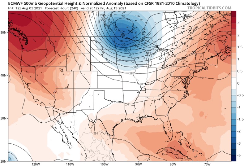
Looks like the climate models might be right about the SE Canada/NE ridge.
5 likes
-
AlphaToOmega
- Category 5

- Posts: 1448
- Joined: Sat Jun 26, 2021 10:51 am
- Location: Somewhere in Massachusetts
Re: 2021 Indicators: SST's / SAL / MSLP / Shear / Steering / Instability / Sat Images
Invest 91L has a 10% chance of developing within 5 days. The new disturbance has a 20% chance of developing within 5 days. Doing some quick mathematics, there is a 28% chance of seeing development within 5 days.
1 likes
-
Category5Kaiju

- Category 5
- Posts: 4335
- Joined: Thu Dec 24, 2020 12:45 pm
- Location: Seattle during the summer, Phoenix during the winter
Re: 2021 Indicators: SST's / SAL / MSLP / Shear / Steering / Instability / Sat Images
captainbarbossa19 wrote:https://i.imgur.com/m3ONOKU.png
Looks like the climate models might be right about the SE Canada/NE ridge.
Yeah that’s a pretty sinister looking steering pattern. Hopefully it does not stick around because that could really increase land risks later this season.
0 likes
Unless explicitly stated, all information in my posts is based on my own opinions and observations. Tropical storms and hurricanes can be extremely dangerous. Refer to an accredited weather research agency or meteorologist if you need to make serious decisions regarding an approaching storm.
-
SFLcane

- S2K Supporter

- Posts: 10281
- Age: 48
- Joined: Sat Jun 05, 2010 1:44 pm
- Location: Lake Worth Florida
Re: 2021 Indicators: SST's / SAL / MSLP / Shear / Steering / Instability / Sat Images
captainbarbossa19 wrote:https://i.imgur.com/m3ONOKU.png
Looks like the climate models might be right about the SE Canada/NE ridge.
Except for the diving trough Day 10.
0 likes
-
captainbarbossa19
- Professional-Met
- Posts: 1094
- Age: 27
- Joined: Wed Aug 21, 2019 11:09 pm
- Location: Beaumont, TX
Re: 2021 Indicators: SST's / SAL / MSLP / Shear / Steering / Instability / Sat Images
SFLcane wrote:captainbarbossa19 wrote:https://i.imgur.com/m3ONOKU.png
Looks like the climate models might be right about the SE Canada/NE ridge.
Except for the diving trough Day 10.
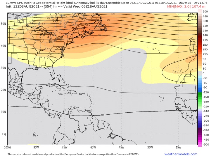
https://i.postimg.cc/xTGsPZn4/BC841-B71-2-B99-4-AB7-9-A1-C-47159062852-B.jpg
True, but how likely is a trough going to verify that far out? Yes, we have been having troughs already this month, but it is way too early I think to presume that this pattern will verify.
0 likes
-
SFLcane
- S2K Supporter
- Posts: 10281
- Age: 48
- Joined: Sat Jun 05, 2010 1:44 pm
- Location: Lake Worth Florida
Re: 2021 Indicators: SST's / SAL / MSLP / Shear / Steering / Instability / Sat Images
captainbarbossa19 wrote:SFLcane wrote:captainbarbossa19 wrote:https://i.imgur.com/m3ONOKU.png
Looks like the climate models might be right about the SE Canada/NE ridge.
Except for the diving trough Day 10.
https://i.postimg.cc/xTGsPZn4/BC841-B71-2-B99-4-AB7-9-A1-C-47159062852-B.jpg
True, but how likely is a trough going to verify that far out? Yes, we have been having troughs already this month, but it is way too early I think to presume that this pattern will verify.
I'm sure it will look different but a ridge at Day 7 doesn't mean a ridge at peak season necessarily.
4 likes
-
captainbarbossa19
- Professional-Met
- Posts: 1094
- Age: 27
- Joined: Wed Aug 21, 2019 11:09 pm
- Location: Beaumont, TX
Re: 2021 Indicators: SST's / SAL / MSLP / Shear / Steering / Instability / Sat Images
SFLcane wrote:captainbarbossa19 wrote:SFLcane wrote:
Except for the diving trough Day 10.
https://i.postimg.cc/xTGsPZn4/BC841-B71-2-B99-4-AB7-9-A1-C-47159062852-B.jpg
True, but how likely is a trough going to verify that far out? Yes, we have been having troughs already this month, but it is way too early I think to presume that this pattern will verify.
I'm sure it will look different but a ridge at Day 7 doesn't mean a ridge at peak season necessarily.
True. Hopefully that trough will be there if anything is heading towards the CONUS and if there is anything, it will not impact any land areas.
0 likes
-
Category5Kaiju
- Category 5
- Posts: 4335
- Joined: Thu Dec 24, 2020 12:45 pm
- Location: Seattle during the summer, Phoenix during the winter
Re: 2021 Indicators: SST's / SAL / MSLP / Shear / Steering / Instability / Sat Images
Wouldn't that sort of trough position pull any low latitude system more northward but also more toward the Gulf Coast or Florida?
0 likes
Unless explicitly stated, all information in my posts is based on my own opinions and observations. Tropical storms and hurricanes can be extremely dangerous. Refer to an accredited weather research agency or meteorologist if you need to make serious decisions regarding an approaching storm.
-
SFLcane
- S2K Supporter
- Posts: 10281
- Age: 48
- Joined: Sat Jun 05, 2010 1:44 pm
- Location: Lake Worth Florida
Re: 2021 Indicators: SST's / SAL / MSLP / Shear / Steering / Instability / Sat Images
This keeps showing up… 
1 likes
-
captainbarbossa19
- Professional-Met
- Posts: 1094
- Age: 27
- Joined: Wed Aug 21, 2019 11:09 pm
- Location: Beaumont, TX
Re: 2021 Indicators: SST's / SAL / MSLP / Shear / Steering / Instability / Sat Images
SFLcane wrote:This keeps showing up…
https://i.postimg.cc/W4jLpZSd/0-BD164-F4-7455-4983-8425-9-F7-C9-A411891.jpg
The GFS is showing something similar in its long-range guidance.
1 likes
-
Kingarabian

- S2K Supporter
- Posts: 16366
- Joined: Sat Aug 08, 2009 3:06 am
- Location: Honolulu, Hawaii
Re: 2021 Indicators: SST's / SAL / MSLP / Shear / Steering / Instability / Sat Images
wxman57 wrote:Euro is forecasting an additional 13 named storms in the Atlantic, with 7 hurricanes. Below-normal in the East Pac with an additional 9 named storms with 4 hurricanes there. Sounds about right. Activity should pick up the last half of August with quite a bit of activity in September and October. Building La Nina through the fall/winter may make for a late ending season. Hurricane to threaten the FL Peninsula in mid-October, I guarantee it. Right before my trip to Disney...
I still think the MDR will NOT be a very hospitable place for strong storms again this season. Too much dry, sinking air again (like the last couple of years).
A forecast for an additional 9 named storms and another 4 hurricanes in the EPAC would yield a more active season than thought.
1 likes
RIP Kobe Bryant

Re: 2021 Indicators: SST's / SAL / MSLP / Shear / Steering / Instability / Sat Images
SFLcane wrote:NDG wrote:Another look at the sypnotic pattern so far this hurricane season, a definite threat for the whole eastern US even into the eastern GOM.
https://i.imgur.com/tMuZBVS.gif
Honestly it Depends on where stuff forms. What's that composite look like over the last month?
Overall very similar.

0 likes
Re: 2021 Indicators: SST's / SAL / MSLP / Shear / Steering / Instability / Sat Images
Shell Mound wrote:Category5Kaiju wrote:aspen wrote:Phew, 18 total NS and 8 total hurricanes from the Euro. That’s quite aggressive from a model that has continuously underestimated all of the seasons in this recent active streak.
Even if the MDR remains similarly stable as 2018-2020, I still think we’ll see at least one significant storm come from there. 2018 had Florence, 2019 had Lorenzo (and I guess maybe Dorian since it did form in the western MDR), and 2020 had Teddy. Hopefully if one does form, it stays out to sea and becomes a harmless but interesting ACE generator.
Don't forget 2017's Jose and Ophelia; they stayed off to sea and did little damage
wxman57 is referring to storms that become strong while in the MDR. Since 2017 only Lorenzo (2019) became a major hurricane in the MDR. Anyway, roughly two-thirds (67%) of the approximately thirty Category-4+ hurricanes to strike the CONUS since 1851 originated in the MDR, of which about a third (33%) first attained hurricane status while in the MDR, so an inactive MDR would certainly decrease the risk of a Category-4+ landfall on the CONUS, especially of a strong TUTT as well as sinking air is present, given that a middling TS or marginal hurricane would likely struggle to survive the combination of enhanced VWS and marginal thermodynamics, particularly if it is a small system, as is favoured during -AMO cycles and years with high background pressures. Additionally, of the approximately fifteen storms to have made landfall on the CONUS with MSW ≥ 125 kt, roughly one-third (33%) first attained hurricane status while in the MDR.
https://i.ibb.co/V93P6Sw/Ska-rmavbild-2021-08-03-kl-16-38-01.png
Regardless, the upcoming pattern during September looks similar to that which accompanied Hurricane Dean in 2007, keeping most systems south of the CONUS:
https://i.ibb.co/K0Rx6XD/Trough-1.png
https://i.ibb.co/S7dCJtX/2007-Dean-1.gif
https://twitter.com/cyclonicwx/status/1422543516341780497
https://twitter.com/AndyHazelton/status/1422544345480192005
https://twitter.com/AndyHazelton/status/1422544722418090028
https://twitter.com/TorenWX/status/1422545567331270667
https://twitter.com/AndyHazelton/status/1422564836865712130
https://twitter.com/WxPatel/status/1422567842206072834
https://twitter.com/all4hurricanes1/status/1422566575375323141
https://twitter.com/all4hurricanes1/status/1422568524925440005
https://twitter.com/AndyHazelton/status/1422569350360408064
Two things: Do you really look at the CFSv2 for Height forecast across the Tropics? I don't know of anyone that does.
Secondly, the MDR covers all the way west to at least the central Caribbean, per NOAA.
Don't forget that Hurricane Teddy last year became a MH while still over the MDR.
Last edited by NDG on Tue Aug 03, 2021 4:35 pm, edited 1 time in total.
3 likes
-
SFLcane
- S2K Supporter
- Posts: 10281
- Age: 48
- Joined: Sat Jun 05, 2010 1:44 pm
- Location: Lake Worth Florida
Re: 2021 Indicators: SST's / SAL / MSLP / Shear / Steering / Instability / Sat Images
NDG wrote:SFLcane wrote:NDG wrote:Another look at the sypnotic pattern so far this hurricane season, a definite threat for the whole eastern US even into the eastern GOM.
https://i.imgur.com/tMuZBVS.gif
Honestly it Depends on where stuff forms. What's that composite look like over the last month?
Overall very similar.
https://i.imgur.com/ZatZ7Xo.gif
East coast trough though.
0 likes
Re: 2021 Indicators: SST's / SAL / MSLP / Shear / Steering / Instability / Sat Images
SFLcane wrote:NDG wrote:SFLcane wrote:
Honestly it Depends on where stuff forms. What's that composite look like over the last month?
Overall very similar.
https://i.imgur.com/ZatZ7Xo.gif
East coast trough though.
The troughiness over the NE US has only been during the second half of July, but what has been persistent is the ridging over SE Newfoundland and its Atlantic waters, that's why I say that a threat for the whole eastern US could be eminent depending where the troughiness is located at a particular time because of the persistent ridging near Newfoundland we shouldn't see too many OTS storms like in 2010-2012.
7 likes
-
CyclonicFury

- Category 5
- Posts: 2035
- Age: 27
- Joined: Sun Jul 02, 2017 12:32 pm
- Location: NC
- Contact:
Re: 2021 Indicators: SST's / SAL / MSLP / Shear / Steering / Instability / Sat Images
Based on this graphic Phil Klotzbach posted on Twitter, it appears MDR SSTs have caught up very close to the mean of hyperactive seasons - and are above normal overall. With Elsa forming in the MDR earlier this year and becoming a hurricane, as well as Africa remaining wet, I do not think the MDR will be quite as hostile as some expect it will be.

13 likes
NCSU B.S. in Meteorology Class of 2021. Tropical weather blogger at http://www.cyclonicfury.com. My forecasts and thoughts are NOT official, for official forecasts please consult the National Hurricane Center.
-
SFLcane
- S2K Supporter
- Posts: 10281
- Age: 48
- Joined: Sat Jun 05, 2010 1:44 pm
- Location: Lake Worth Florida
Re: 2021 Indicators: SST's / SAL / MSLP / Shear / Steering / Instability / Sat Images
CyclonicFury wrote:Based on this graphic Phil Klotzbach posted on Twitter, it appears MDR SSTs have caught up very close to the mean of hyperactive seasons - and are above normal overall. With Elsa forming in the MDR earlier this year and becoming a hurricane, as well as Africa remaining wet, I do not think the MDR will be quite as hostile as some expect it will be.
https://i.imgur.com/4aJ32GP_d.webp?maxwidth=640&shape=thumb&fidelity=medium
Great post!
1 likes
-
AlphaToOmega
- Category 5
- Posts: 1448
- Joined: Sat Jun 26, 2021 10:51 am
- Location: Somewhere in Massachusetts
Re: 2021 Indicators: SST's / SAL / MSLP / Shear / Steering / Instability / Sat Images
CyclonicFury wrote:Based on this graphic Phil Klotzbach posted on Twitter, it appears MDR SSTs have caught up very close to the mean of hyperactive seasons - and are above normal overall. With Elsa forming in the MDR earlier this year and becoming a hurricane, as well as Africa remaining wet, I do not think the MDR will be quite as hostile as some expect it will be.
https://i.imgur.com/4aJ32GP_d.webp?maxwidth=640&shape=thumb&fidelity=medium
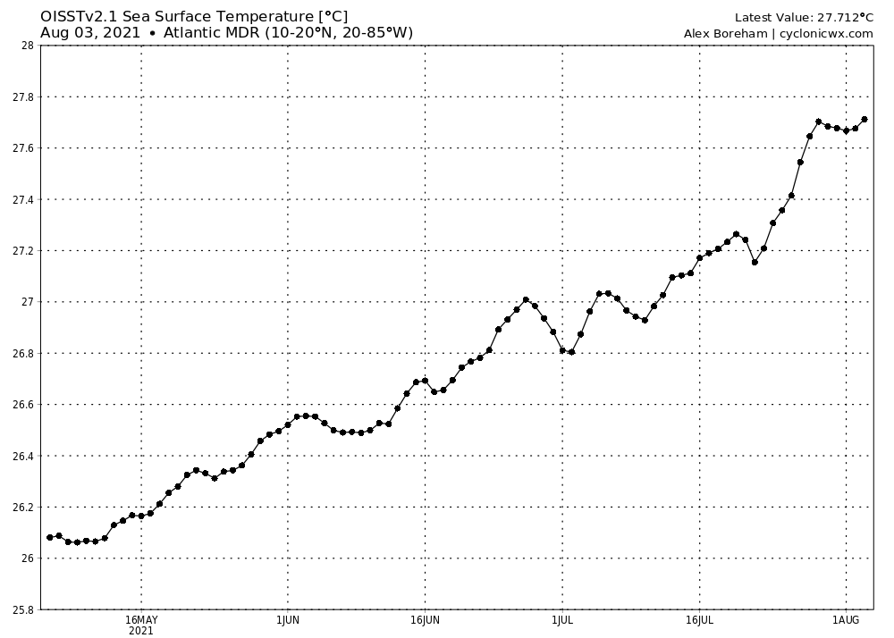
We are actually above the hyperactive average in terms of MDR SSTs. Over the last 14 days, the MDR has been consistently above 27 C. I believe the graph is underestimating MDR temperatures.
0 likes
-
Category5Kaiju
- Category 5
- Posts: 4335
- Joined: Thu Dec 24, 2020 12:45 pm
- Location: Seattle during the summer, Phoenix during the winter
Re: 2021 Indicators: SST's / SAL / MSLP / Shear / Steering / Instability / Sat Images
We literally got one of the earliest hurricanes in the MDR ever recorded, so the MDR now warming up to what would typically be seen in hyperactive years really does not surprise me one bit. It was only a matter of time that the MDR warmed up, contrary to what some people were saying about it remaining cool and being a big - factor in peak season activity.
2 likes
Unless explicitly stated, all information in my posts is based on my own opinions and observations. Tropical storms and hurricanes can be extremely dangerous. Refer to an accredited weather research agency or meteorologist if you need to make serious decisions regarding an approaching storm.
Who is online
Users browsing this forum: dexterlabio, gib and 421 guests