2021 Indicators: SST's / SAL / MSLP / Shear / Steering / Instability / Sat Images

This is the general tropical discussion area. Anyone can take their shot at predicting a storms path.

Moderator: S2k Moderators

Forum rules

The posts in this forum are NOT official forecasts and should not be used as such. They are just the opinion of the poster and may or may not be backed by sound meteorological data. They are NOT endorsed by any professional institution or STORM2K. For official information, please refer to products from the National Hurricane Center and National Weather Service.

Help Support Storm2K
Message
Author
User avatar
SFLcane
S2K Supporter
S2K Supporter
Posts: 10163
Age: 47
Joined: Sat Jun 05, 2010 1:44 pm
Location: Lake Worth Florida

Re: 2021 Indicators: SST's / SAL / MSLP / Shear / Steering / Instability / Sat Images

#2181 Postby SFLcane » Tue Aug 03, 2021 5:52 pm

AlphaToOmega wrote:
CyclonicFury wrote:Based on this graphic Phil Klotzbach posted on Twitter, it appears MDR SSTs have caught up very close to the mean of hyperactive seasons - and are above normal overall. With Elsa forming in the MDR earlier this year and becoming a hurricane, as well as Africa remaining wet, I do not think the MDR will be quite as hostile as some expect it will be.

https://i.imgur.com/4aJ32GP_d.webp?maxwidth=640&shape=thumb&fidelity=medium


We are actually above the hyperactive average in terms of MDR SSTs. Over the last 14 days, the MDR has been consistently above 27 C. I believe the graph is underestimating MDR temperatures.

https://i.postimg.cc/Nf3crBLF/sst-graph-atlmdr.png


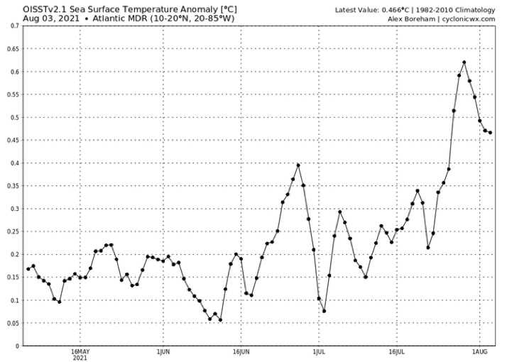
You have to plot the anomaly trend. Otherwise it's just climo. Actually cooling still relative to average

Image
0 likes   

USTropics
Professional-Met
Professional-Met
Posts: 2651
Joined: Sun Aug 12, 2007 3:45 am
Location: Florida State University

Re: 2021 Indicators: SST's / SAL / MSLP / Shear / Steering / Instability / Sat Images

#2182 Postby USTropics » Tue Aug 03, 2021 11:15 pm

SFLcane wrote:
AlphaToOmega wrote:
CyclonicFury wrote:Based on this graphic Phil Klotzbach posted on Twitter, it appears MDR SSTs have caught up very close to the mean of hyperactive seasons - and are above normal overall. With Elsa forming in the MDR earlier this year and becoming a hurricane, as well as Africa remaining wet, I do not think the MDR will be quite as hostile as some expect it will be.

https://i.imgur.com/4aJ32GP_d.webp?maxwidth=640&shape=thumb&fidelity=medium


We are actually above the hyperactive average in terms of MDR SSTs. Over the last 14 days, the MDR has been consistently above 27 C. I believe the graph is underestimating MDR temperatures.

https://i.postimg.cc/Nf3crBLF/sst-graph-atlmdr.png


You have to plot the anomaly trend. Otherwise it's just climo. Actually cooling still relative to average

https://i.postimg.cc/TY6003Q0/F6001-F03-C494-42-B4-943-E-221485-CAFA7-F.jpg


Cooling is concentrated in the eastern MDR currently, here is a trend of the last 7 days:
Image

This in part due to the persistent monsoonal trough that has extended off the coast, here are precipitation anomalies from the past 7 days (quite and active WAM):
Image

We can see a slight rising branch has been established in this region for the past week as well:
Image
11 likes   

User avatar
captainbarbossa19
Professional-Met
Professional-Met
Posts: 1092
Age: 27
Joined: Wed Aug 21, 2019 11:09 pm
Location: Beaumont, TX

Re: 2021 Indicators: SST's / SAL / MSLP / Shear / Steering / Instability / Sat Images

#2183 Postby captainbarbossa19 » Wed Aug 04, 2021 12:05 am

USTropics wrote:
SFLcane wrote:
AlphaToOmega wrote:
We are actually above the hyperactive average in terms of MDR SSTs. Over the last 14 days, the MDR has been consistently above 27 C. I believe the graph is underestimating MDR temperatures.

https://i.postimg.cc/Nf3crBLF/sst-graph-atlmdr.png


You have to plot the anomaly trend. Otherwise it's just climo. Actually cooling still relative to average

https://i.postimg.cc/TY6003Q0/F6001-F03-C494-42-B4-943-E-221485-CAFA7-F.jpg


Cooling is concentrated in the eastern MDR currently, here is a trend of the last 7 days:
https://i.imgur.com/1Mx2mVQ.png

This in part due to the persistent monsoonal trough that has extended off the coast, here are precipitation anomalies from the past 7 days (quite and active WAM):
https://i.imgur.com/rx38jNY.png

We can see a slight rising branch has been established in this region for the past week as well:
https://i.imgur.com/M9Nu5N8.png


Looks like the Gulf and Bahamas region are still warming too. :eek:
0 likes   

Shell Mound
Category 5
Category 5
Posts: 2434
Age: 32
Joined: Thu Sep 07, 2017 3:39 pm
Location: St. Petersburg, FL → Scandinavia

Re: 2021 Indicators: SST's / SAL / MSLP / Shear / Steering / Instability / Sat Images

#2184 Postby Shell Mound » Wed Aug 04, 2021 3:47 am


...except nothing is likely to be out there before the last few days of August. August 18 is still too early. By early September that ridge is likely to be gone. According to the CFSv2’s weeklies, ridging over southeastern Canada is likely to be strongest during 18–25 August, so if a TC were present near the islands during that timeframe, it would be in a prime position to affect the CONUS. Afterward, however, the CFSv2 shows ridging gradually shifting northward and leaving a trough underneath in time for the peak of the season. So maybe the CONUS will escape serious impacts this season, given that most Category-4+ landfalls tend to be associated with storms that develop in the MDR.

Image

 https://twitter.com/AndyHazelton/status/1422658917344108554


0 likes   
CVW / MiamiensisWx / Shell Mound
The posts in this forum are NOT official forecasts and should not be used as such. They are just the opinion of the poster and may or may not be backed by sound meteorological data. They are NOT endorsed by any professional institution or STORM2K. For official information, please refer to products from the NHC and NWS.

User avatar
weeniepatrol
Category 5
Category 5
Posts: 1276
Joined: Sat Aug 22, 2020 5:30 pm
Location: WA State

Re: 2021 Indicators: SST's / SAL / MSLP / Shear / Steering / Instability / Sat Images

#2185 Postby weeniepatrol » Wed Aug 04, 2021 4:19 am

I know shear maps are extremely transient, but honestly, if this is how insignificant the TUTT is before the MJO is even close to being in a favorable position for the Atlantic and we have weeks and weeks of gradually improving conditions consistent with climatology then i'm terrified for later this month. :eek:

Low shear and deep-layered easterlies already dominate from Africa to the Caribbean Sea..

Image
6 likes   

AlphaToOmega
Category 5
Category 5
Posts: 1448
Joined: Sat Jun 26, 2021 10:51 am
Location: Somewhere in Massachusetts

Re: 2021 Indicators: SST's / SAL / MSLP / Shear / Steering / Instability / Sat Images

#2186 Postby AlphaToOmega » Wed Aug 04, 2021 7:24 am

There are three disturbances in the Atlantic as of now.
ZCZC MIATWOAT ALL
TTAA00 KNHC DDHHMM CCA

Tropical Weather Outlook...Corrected
NWS National Hurricane Center Miami FL
800 AM EDT Wed Aug 4 2021

Corrected order of disturbances

For the North Atlantic...Caribbean Sea and the Gulf of Mexico:

1. A small and weak area of low pressure, with limited shower and
thunderstorm activity, is passing near the Cabo Verde Islands.
Significant development of this system is not expected during the
next day or so due to unfavorable environmental conditions.
Thereafter, this system is forecast to move northward or
north-northwestward over cooler waters, ending its development
chances. Locally heavy rainfall and gusty winds are possible over
portions of the Cabo Verde Islands through today.
* Formation chance through 48 hours...low...near 0 percent.
* Formation chance through 5 days...low...near 0 percent.

2. A tropical wave located over the central tropical Atlantic is
producing a broad area of disorganized showers and thunderstorms.
Environmental conditions are expected to be marginally conducive
for some slow development east of the Lesser Antilles by Sunday and
into early next week while the disturbance moves west-northwestward
at 10 to 15 mph.
* Formation chance through 48 hours...low...near 0 percent.
* Formation chance through 5 days...low...20 percent.

3. A tropical wave is forecast to move off the west coast of Africa by
late Thursday. Environmental conditions appear somewhat conducive
for some slow development over the far eastern Atlantic through the
weekend into early next week while the system moves generally
westward at about 15 mph.
* Formation chance through 48 hours...low...near 0 percent.
* Formation chance through 5 days...low...30 percent.
Forecaster Stewart

If these numbers are to be trusted, the chance of Disturbance II developing is 20%; the chance of Disturbance III developing is 30%. Therefore, the chance of Disturbance II not developing is 80%; Disturbance III, 70%. Therefore, the chance of neither disturbance developing is 0.8 * 0.7 = 56%. There is a 42% chance of a disturbance developing within 5 days.
0 likes   

User avatar
Category5Kaiju
Category 5
Category 5
Posts: 4097
Joined: Thu Dec 24, 2020 12:45 pm
Location: Seattle

Re: 2021 Indicators: SST's / SAL / MSLP / Shear / Steering / Instability / Sat Images

#2187 Postby Category5Kaiju » Wed Aug 04, 2021 8:12 am

weeniepatrol wrote:I know shear maps are extremely transient, but honestly, if this is how insignificant the TUTT is before the MJO is even close to being in a favorable position for the Atlantic and we have weeks and weeks of gradually improving conditions consistent with climatology then i'm terrified for later this month. :eek:

Low shear and deep-layered easterlies already dominate from Africa to the Caribbean Sea..

https://i.imgur.com/HebEnbA.gif


Hmm, well I guess the ECAR may not be as much as a graveyard as it has been in previous years :double: we’ll see though.
0 likes   
Unless explicitly stated, all info in my posts is based on my own opinions and observations. Tropical storms and hurricanes can be extremely dangerous. Do not think you can beat Mother Nature. Refer to an accredited weather research agency or meteorologist if you need to make serious decisions regarding an approaching storm.

AutoPenalti
Category 5
Category 5
Posts: 4030
Age: 29
Joined: Mon Aug 17, 2015 4:16 pm
Location: Ft. Lauderdale, Florida

Re: 2021 Indicators: SST's / SAL / MSLP / Shear / Steering / Instability / Sat Images

#2188 Postby AutoPenalti » Wed Aug 04, 2021 8:20 am

AlphaToOmega wrote:There are three disturbances in the Atlantic as of now.
ZCZC MIATWOAT ALL
TTAA00 KNHC DDHHMM CCA

Tropical Weather Outlook...Corrected
NWS National Hurricane Center Miami FL
800 AM EDT Wed Aug 4 2021

Corrected order of disturbances

For the North Atlantic...Caribbean Sea and the Gulf of Mexico:

1. A small and weak area of low pressure, with limited shower and
thunderstorm activity, is passing near the Cabo Verde Islands.
Significant development of this system is not expected during the
next day or so due to unfavorable environmental conditions.
Thereafter, this system is forecast to move northward or
north-northwestward over cooler waters, ending its development
chances. Locally heavy rainfall and gusty winds are possible over
portions of the Cabo Verde Islands through today.
* Formation chance through 48 hours...low...near 0 percent.
* Formation chance through 5 days...low...near 0 percent.

2. A tropical wave located over the central tropical Atlantic is
producing a broad area of disorganized showers and thunderstorms.
Environmental conditions are expected to be marginally conducive
for some slow development east of the Lesser Antilles by Sunday and
into early next week while the disturbance moves west-northwestward
at 10 to 15 mph.
* Formation chance through 48 hours...low...near 0 percent.
* Formation chance through 5 days...low...20 percent.

3. A tropical wave is forecast to move off the west coast of Africa by
late Thursday. Environmental conditions appear somewhat conducive
for some slow development over the far eastern Atlantic through the
weekend into early next week while the system moves generally
westward at about 15 mph.
* Formation chance through 48 hours...low...near 0 percent.
* Formation chance through 5 days...low...30 percent.
Forecaster Stewart

If these numbers are to be trusted, the chance of Disturbance II developing is 20%; the chance of Disturbance III developing is 30%. Therefore, the chance of Disturbance II not developing is 80%; Disturbance III, 70%. Therefore, the chance of neither disturbance developing is 0.8 * 0.7 = 56%. There is a 42% chance of a disturbance developing within 5 days.

4 days into August and we are at 3 disturbances.
2 likes   
The posts in this forum are NOT official forecasts and should not be used as such. They are just the opinion of the poster and may or may not be backed by sound meteorological data. They are NOT endorsed by any professional institution or STORM2K. For official information, please refer to products from the NHC and NWS.


Model Runs Cheat Sheet:
GFS (5:30 AM/PM, 11:30 AM/PM)
HWRF, GFDL, UKMET, NAVGEM (6:30-8:00 AM/PM, 12:30-2:00 AM/PM)
ECMWF (1:45 AM/PM)

TCVN
is a weighted averaged

User avatar
SFLcane
S2K Supporter
S2K Supporter
Posts: 10163
Age: 47
Joined: Sat Jun 05, 2010 1:44 pm
Location: Lake Worth Florida

Re: 2021 Indicators: SST's / SAL / MSLP / Shear / Steering / Instability / Sat Images

#2189 Postby SFLcane » Wed Aug 04, 2021 8:43 am

:crazyeyes:

Image
7 likes   

User avatar
aspen
Category 5
Category 5
Posts: 8818
Joined: Sat Oct 12, 2019 7:10 pm
Location: Connecticut, USA

Re: 2021 Indicators: SST's / SAL / MSLP / Shear / Steering / Instability / Sat Images

#2190 Postby aspen » Wed Aug 04, 2021 8:49 am

The Atlantic is finally starting to wake up…

With so many active waves and many more to come, we really need to watch out for anything that makes it into the Gulf. The entire region is at least 30C, with half of the Gulf having 31-32C SSTs, along with the broiling Loop Current. It’s a powder keg waiting to be lit. I don’t know how much the EPac -VP cell will suppress activity there, however.
0 likes   
Irene '11 Sandy '12 Hermine '16 5/15/2018 Derecho Fay '20 Isaias '20 Elsa '21 Henri '21 Ida '21

I am only a meteorology enthusiast who knows a decent amount about tropical cyclones. Look to the professional mets, the NHC, or your local weather office for the best information.

SconnieCane
Category 4
Category 4
Posts: 998
Joined: Thu Aug 02, 2018 5:29 pm
Location: Madison, WI

Re: 2021 Indicators: SST's / SAL / MSLP / Shear / Steering / Instability / Sat Images

#2191 Postby SconnieCane » Wed Aug 04, 2021 8:50 am

Shell Mound wrote:

...except nothing is likely to be out there before the last few days of August. August 18 is still too early. By early September that ridge is likely to be gone. According to the CFSv2’s weeklies, ridging over southeastern Canada is likely to be strongest during 18–25 August, so if a TC were present near the islands during that timeframe, it would be in a prime position to affect the CONUS. Afterward, however, the CFSv2 shows ridging gradually shifting northward and leaving a trough underneath in time for the peak of the season. So maybe the CONUS will escape serious impacts this season, given that most Category-4+ landfalls tend to be associated with storms that develop in the MDR.

https://i.ibb.co/xf29FNH/Weekly-1.png

https://twitter.com/AndyHazelton/status/1422658917344108554


I think you're putting way too much stock in the CFS at a month out.
5 likes   

User avatar
Category5Kaiju
Category 5
Category 5
Posts: 4097
Joined: Thu Dec 24, 2020 12:45 pm
Location: Seattle

Re: 2021 Indicators: SST's / SAL / MSLP / Shear / Steering / Instability / Sat Images

#2192 Postby Category5Kaiju » Wed Aug 04, 2021 8:57 am

aspen wrote:The Atlantic is finally starting to wake up…

With so many active waves and many more to come, we really need to watch out for anything that makes it into the Gulf. The entire region is at least 30C, with half of the Gulf having 31-32C SSTs, along with the broiling Loop Current. It’s a powder keg waiting to be lit. I don’t know how much the EPac -VP cell will suppress activity there, however.


For real, let's hope we don't get any storm that is able to take full advantage of those conditions and blow up into a monster stronger than the most powerful Gulf storm recorded, Rita. :ggreen: If in recent years RI Gulf storms have been the norm, then I can only imagine what those really warm waters and highly pronounced Loop Current would be capable of supporting; it ain't pretty one bit.
0 likes   
Unless explicitly stated, all info in my posts is based on my own opinions and observations. Tropical storms and hurricanes can be extremely dangerous. Do not think you can beat Mother Nature. Refer to an accredited weather research agency or meteorologist if you need to make serious decisions regarding an approaching storm.

AlphaToOmega
Category 5
Category 5
Posts: 1448
Joined: Sat Jun 26, 2021 10:51 am
Location: Somewhere in Massachusetts

Re: 2021 Indicators: SST's / SAL / MSLP / Shear / Steering / Instability / Sat Images

#2193 Postby AlphaToOmega » Wed Aug 04, 2021 9:05 am

aspen wrote:The Atlantic is finally starting to wake up…

With so many active waves and many more to come, we really need to watch out for anything that makes it into the Gulf. The entire region is at least 30C, with half of the Gulf having 31-32C SSTs, along with the broiling Loop Current. It’s a powder keg waiting to be lit. I don’t know how much the EPac -VP cell will suppress activity there, however.


An EPAC -VP cell will not hinder West Atlantic tropical activity. Remember 2005: there was an EPac -VP cell; yet there was Dennis, Emily, Katrina, Rita, Wilma, and Beta, all powerful Western Atlantic hurricanes. The warm Gulf of Mexico will likely be enough to support a major hurricane.
0 likes   

psyclone
S2K Supporter
S2K Supporter
Posts: 4762
Joined: Wed Aug 24, 2005 9:04 pm
Location: palm harbor fl

Re: 2021 Indicators: SST's / SAL / MSLP / Shear / Steering / Instability / Sat Images

#2194 Postby psyclone » Wed Aug 04, 2021 9:10 am

aspen wrote:The Atlantic is finally starting to wake up…

With so many active waves and many more to come, we really need to watch out for anything that makes it into the Gulf. The entire region is at least 30C, with half of the Gulf having 31-32C SSTs, along with the broiling Loop Current. It’s a powder keg waiting to be lit. I don’t know how much the EPac -VP cell will suppress activity there, however.


Speaking on a hyperlocal basis...the shelf waters over much of the gulf are at very warm levels that would permit a storm to strengthen right up until landfall. We've had quite a bit of onshore flow here lately and it has been just obnoxious at night as that marine layer advects landward. temps in the mid 80's at night with upper 70's dewpoints have been common...true "head in the dishwasher" conditions. If a storm is able to take advantage of that...it's going to be problematic.
0 likes   

User avatar
Category5Kaiju
Category 5
Category 5
Posts: 4097
Joined: Thu Dec 24, 2020 12:45 pm
Location: Seattle

Re: 2021 Indicators: SST's / SAL / MSLP / Shear / Steering / Instability / Sat Images

#2195 Postby Category5Kaiju » Wed Aug 04, 2021 9:20 am

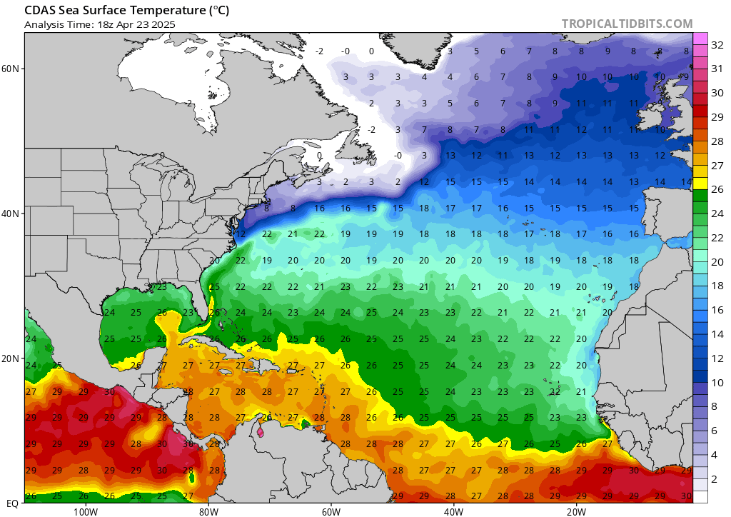
Image

If you looks closely at the Gulf, you can definitely see patches of water near the dreaded 32 C mark (especially off of Key West and the South Florida tip). Nice to swim in, until you realize that that is just sitting rocket fuel for any hurricanes that go over it.
2 likes   
Unless explicitly stated, all info in my posts is based on my own opinions and observations. Tropical storms and hurricanes can be extremely dangerous. Do not think you can beat Mother Nature. Refer to an accredited weather research agency or meteorologist if you need to make serious decisions regarding an approaching storm.

User avatar
aspen
Category 5
Category 5
Posts: 8818
Joined: Sat Oct 12, 2019 7:10 pm
Location: Connecticut, USA

Re: 2021 Indicators: SST's / SAL / MSLP / Shear / Steering / Instability / Sat Images

#2196 Postby aspen » Wed Aug 04, 2021 9:23 am

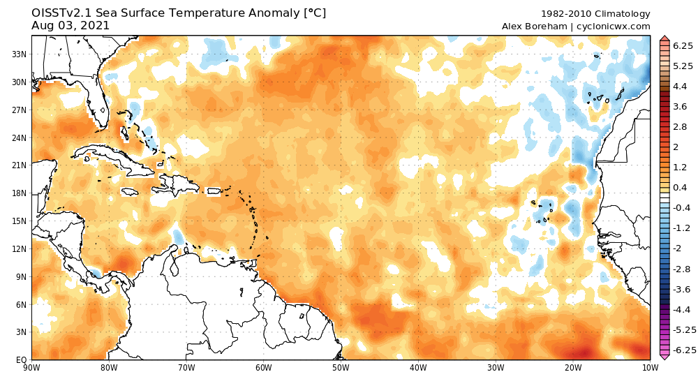
What’s up with that persistent stream of -SST anomalies coming from the ABC islands? It’s been there for weeks, and in SST maps from 2020 that have been posted, it is either very weak or non-existent.
0 likes   
Irene '11 Sandy '12 Hermine '16 5/15/2018 Derecho Fay '20 Isaias '20 Elsa '21 Henri '21 Ida '21

I am only a meteorology enthusiast who knows a decent amount about tropical cyclones. Look to the professional mets, the NHC, or your local weather office for the best information.

Shell Mound
Category 5
Category 5
Posts: 2434
Age: 32
Joined: Thu Sep 07, 2017 3:39 pm
Location: St. Petersburg, FL → Scandinavia

Re: 2021 Indicators: SST's / SAL / MSLP / Shear / Steering / Instability / Sat Images

#2197 Postby Shell Mound » Wed Aug 04, 2021 9:26 am

Category5Kaiju wrote:
aspen wrote:...we really need to watch out for anything that makes it into the Gulf. The entire region is at least... It’s a powder keg waiting to be lit.

For real, let's hope we don't get any storm that is able to take full advantage of those conditions and blow up into a monster

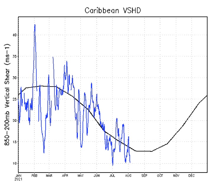
Regarding the Gulf: we say the same thing every year. :wink: It’s a broken record. The Gulf is always sufficiently warm to support Category-5 cyclones, even during -AMO cycles. “Record-high” SST and/or THC in the Gulf are irrelevant, whereas shear and dry air are relevant. Anyway, vertical wind shear was above average in the Caribbean during July 2021, which would actually correlate with lower seasonal ACE. Combined with the -VP over the EPAC, this could indicate more hostile conditions over the Gulf, Caribbean, and western MDR during the peak period of ASO.
1 likes   
CVW / MiamiensisWx / Shell Mound
The posts in this forum are NOT official forecasts and should not be used as such. They are just the opinion of the poster and may or may not be backed by sound meteorological data. They are NOT endorsed by any professional institution or STORM2K. For official information, please refer to products from the NHC and NWS.

AlphaToOmega
Category 5
Category 5
Posts: 1448
Joined: Sat Jun 26, 2021 10:51 am
Location: Somewhere in Massachusetts

Re: 2021 Indicators: SST's / SAL / MSLP / Shear / Steering / Instability / Sat Images

#2198 Postby AlphaToOmega » Wed Aug 04, 2021 9:27 am

aspen wrote:What’s up with that persistent stream of -SST anomalies coming from the ABC islands? It’s been there for weeks, and in SST maps from 2020 that have been posted, it is either very weak or non-existent.

Image
1 likes   

AlphaToOmega
Category 5
Category 5
Posts: 1448
Joined: Sat Jun 26, 2021 10:51 am
Location: Somewhere in Massachusetts

Re: 2021 Indicators: SST's / SAL / MSLP / Shear / Steering / Instability / Sat Images

#2199 Postby AlphaToOmega » Wed Aug 04, 2021 9:28 am

Shell Mound wrote:
Category5Kaiju wrote:
aspen wrote:...we really need to watch out for anything that makes it into the Gulf. The entire region is at least... It’s a powder keg waiting to be lit.

For real, let's hope we don't get any storm that is able to take full advantage of those conditions and blow up into a monster

Regarding the Gulf: we say the same thing every year. :wink: It’s a broken record. The Gulf is always sufficiently warm to support Category-5 cyclones, even during -AMO cycles. “Record-high” SST and/or THC in the Gulf are irrelevant, whereas shear and dry air are relevant. Anyway, vertical wind shear was above average in the Caribbean during July 2021, which would actually correlate with lower seasonal ACE. Combined with the -VP over the EPAC, this could indicate more hostile conditions over the Gulf, Caribbean, and western MDR during the peak period of ASO.

A -VP cell in the EPac is irrelevant. 2005 had a -VP cell in the EPAC; yet Hurricanes Dennis, Emily, Katrina, Rita, Wilma, and Beta formed, all of which were Western Atlantic major hurricanes. :spam:
1 likes   

AlphaToOmega
Category 5
Category 5
Posts: 1448
Joined: Sat Jun 26, 2021 10:51 am
Location: Somewhere in Massachusetts

Re: 2021 Indicators: SST's / SAL / MSLP / Shear / Steering / Instability / Sat Images

#2200 Postby AlphaToOmega » Wed Aug 04, 2021 9:32 am

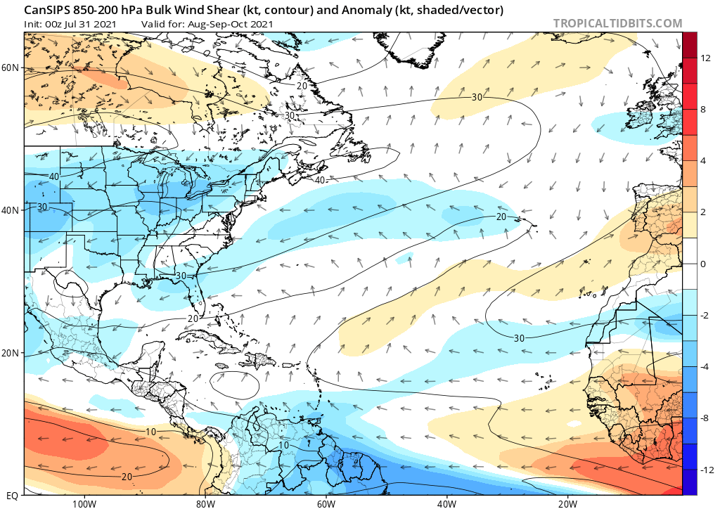
Notice the below-average wind shear in the Caribbean Sea and the Gulf of Mexico
Image
It is nothing but wishful thinking to assume the Caribbean Sea and/or the Gulf of Mexico will be hostile for tropical development.
8 likes   


Return to “Talkin' Tropics”

Who is online

Users browsing this forum: Google [Bot], lilbump3000, Sps123, TampaWxLurker and 42 guests