I know the models are not showing anything but
there is a lot thunderstorm activity in the Gulf. It is from
the front that just moved offshore.
Old front in Gulf
Moderator: S2k Moderators
Forum rules

The posts in this forum are NOT official forecasts and should not be used as such. They are just the opinion of the poster and may or may not be backed by sound meteorological data. They are NOT endorsed by any professional institution or STORM2K. For official information, please refer to products from the National Hurricane Center and National Weather Service.
-
Stormcenter
- S2K Supporter

- Posts: 6689
- Joined: Wed Sep 03, 2003 11:27 am
- Location: Houston, TX
Old front in Gulf
0 likes

Re: Old front in Gulf
Were you thinking of something developing off the East or West coast of Florida?
Edit to add: This is a somewhat rare cold front for August digging this far south, so even the mid gulf buoy might be worth monitoring.
Edit to add: This is a somewhat rare cold front for August digging this far south, so even the mid gulf buoy might be worth monitoring.
Last edited by Nimbus on Wed Aug 04, 2021 2:46 pm, edited 1 time in total.
0 likes
-
Category5Kaiju

- Category 5

- Posts: 4346
- Joined: Thu Dec 24, 2020 12:45 pm
- Location: Seattle during the summer, Phoenix during the winter
Re: Old front in Gulf
I was thinking this front would have spawned a TC easily, but then I keep reminding myself that this year has not really been acting like 2020 in that sense, when every front literally spawned like 2 TCs 
4 likes
Unless explicitly stated, all information in my posts is based on my own opinions and observations. Tropical storms and hurricanes can be extremely dangerous. Refer to an accredited weather research agency or meteorologist if you need to make serious decisions regarding an approaching storm.
-
AlphaToOmega
- Category 5
- Posts: 1448
- Joined: Sat Jun 26, 2021 10:51 am
- Location: Somewhere in Massachusetts
Re: Old front in Gulf
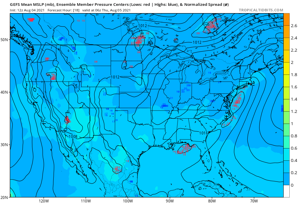
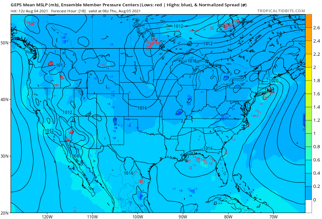
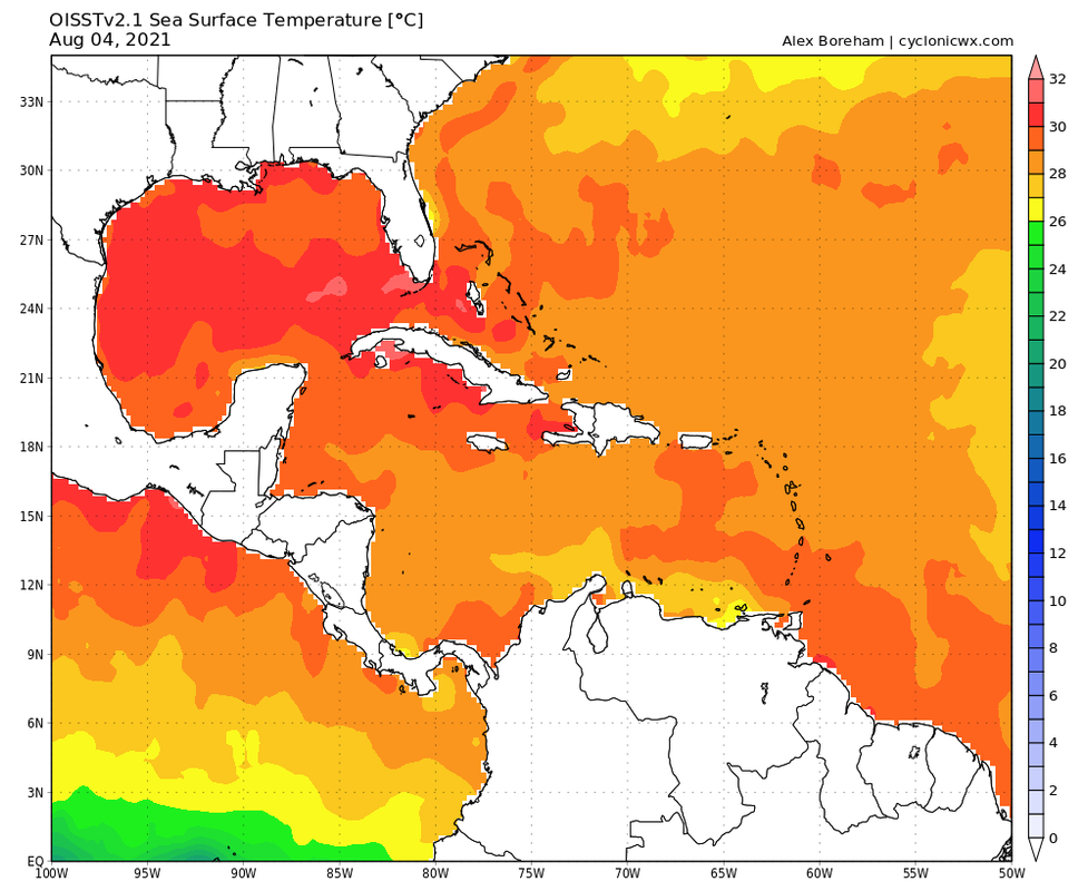
Conditions seem conducive enough for tropical development, and the system has ensemble support. SSTs are warm enough to support a tropical storm.
0 likes
Re: Old front in Gulf
Lowest surface pressure I could find is near Pilots station south of NOLA.
Slow steady drop in pressure from 30.06 to 29.89 as the front reached the gulf.
No centered convective burst yet but chances are increasing.
https://www.ndbc.noaa.gov/station_page. ... tion=PSTL1
Slow steady drop in pressure from 30.06 to 29.89 as the front reached the gulf.
No centered convective burst yet but chances are increasing.
https://www.ndbc.noaa.gov/station_page. ... tion=PSTL1
1 likes
-
AlphaToOmega
- Category 5
- Posts: 1448
- Joined: Sat Jun 26, 2021 10:51 am
- Location: Somewhere in Massachusetts
Re: Old front in Gulf
...GULF OF MEXICO...
A slow-moving cold front stretches westward from the Florida
Big Bend to Corpus Christi, Texas. Numerous showers and
scattered thunderstorms are evident across the Gulf north of 25N.
Moderate to locally fresh winds and seas up to 6 ft are near
these thunderstorms.
A surface ridge extends west-southwestward from the Straits of
Florida across the central Gulf to central Mexico. Convergent SE
winds near the ridge axis are coupling with divergent winds aloft
to trigger scattered showers and thunderstorms over the east-central
Gulf and Florida Peninsula. An upper-level low near the eastern
coast of Mexico at 28N98W is supporting isolated showers and
isolated thunderstorms across the western Gulf. The surface ridge
continues to support gentle to moderate winds and seas of 2 to 4
ft across the central and S Gulf.
For the forecast, a slow-moving cold front from the Florida Big
Bend to Corpus Christi, Texas will become stationary tonight over
the northern Gulf of Mexico. On the Fri, the front will weaken as
it lifts northward. Scattered showers and thunderstorms will
continue over the northern half of the Gulf of Mexico through Fri.
Moderate SW to W winds will prevail south of the front in the
northeastern Gulf through this evening. Moderate to fresh E winds
will pulse off the NW Yucatan Peninsula into the Bay of Campeche
every night through Mon night in association with a diurnal
trough. Elsewhere south of the front, a surface ridge will
dominate the Gulf waters over the next several days producing
gentle to moderate anticyclonic winds.
1 likes
-
tropicwatch

- Category 5
- Posts: 3427
- Age: 62
- Joined: Sat Jun 02, 2007 10:01 am
- Location: The Villages, Florida
- Contact:
Re: Old front in Gulf
There is some decent 925 and 850mb vorticity in the Gulf of Mexico south of Apalachicola.
925mb
http://tropic.ssec.wisc.edu/real-time/windmain.php?&basin=atlantic&sat=wg8&prod=vor5&zoom=&time=
850mb
http://tropic.ssec.wisc.edu/real-time/windmain.php?&basin=atlantic&sat=wg8&prod=vor&zoom=&time=
925mb
http://tropic.ssec.wisc.edu/real-time/windmain.php?&basin=atlantic&sat=wg8&prod=vor5&zoom=&time=
850mb
http://tropic.ssec.wisc.edu/real-time/windmain.php?&basin=atlantic&sat=wg8&prod=vor&zoom=&time=
0 likes
Tropicwatch
Agnes 72', Eloise 75, Elena 85', Kate 85', Charley 86', Florence 88', Beryl 94', Dean 95', Erin 95', Opal 95', Earl 98', Georges 98', Ivan 2004', Arlene 2005', Dennis 2005', Ida 2009' Debby 2012' Irma 2017' Michael 2018'
Agnes 72', Eloise 75, Elena 85', Kate 85', Charley 86', Florence 88', Beryl 94', Dean 95', Erin 95', Opal 95', Earl 98', Georges 98', Ivan 2004', Arlene 2005', Dennis 2005', Ida 2009' Debby 2012' Irma 2017' Michael 2018'
Re: Old front in Gulf
panamatropicwatch wrote:There is some decent 925 and 850mb vorticity in the Gulf of Mexico south of Apalachicola.
925mb
http://tropic.ssec.wisc.edu/real-time/windmain.php?&basin=atlantic&sat=wg8&prod=vor5&zoom=&time=
850mb
http://tropic.ssec.wisc.edu/real-time/windmain.php?&basin=atlantic&sat=wg8&prod=vor&zoom=&time=
The upper level high centered mid gulf is providing shear, but convection is waxing mid gulf as well.
0 likes
Who is online
Users browsing this forum: pepecool20 and 209 guests