https://twitter.com/AndyHazelton/status/1422588610029703170
2021 Global Model Runs Discussion (Out thru day 16)
Moderator: S2k Moderators
Forum rules

The posts in this forum are NOT official forecasts and should not be used as such. They are just the opinion of the poster and may or may not be backed by sound meteorological data. They are NOT endorsed by any professional institution or STORM2K. For official information, please refer to products from the National Hurricane Center and National Weather Service.
-
cycloneye

- Admin

- Posts: 149505
- Age: 69
- Joined: Thu Oct 10, 2002 10:54 am
- Location: San Juan, Puerto Rico
Re: 2021 Global Model Runs Discussion (Out thru day 16)
0 likes
Visit the Caribbean-Central America Weather Thread where you can find at first post web cams,radars
and observations from Caribbean basin members Click Here
and observations from Caribbean basin members Click Here

Re: 2021 Global Model Runs Discussion (Out thru day 16)
cycloneye wrote:https://twitter.com/AndyHazelton/status/1422588610029703170
I was about to post how the wave quickly developed but got a little too north and weakened. However, if it continues westward after that and doesn’t completely die, it would run into warmer SSTs and perhaps have a chance there.
1 likes
Irene '11 Sandy '12 Hermine '16 5/15/2018 Derecho Fay '20 Isaias '20 Elsa '21 Henri '21 Ida '21
I am only a meteorology enthusiast who knows a decent amount about tropical cyclones. Look to the professional mets, the NHC, or your local weather office for the best information.
I am only a meteorology enthusiast who knows a decent amount about tropical cyclones. Look to the professional mets, the NHC, or your local weather office for the best information.
-
captainbarbossa19

- Professional-Met

- Posts: 1094
- Age: 27
- Joined: Wed Aug 21, 2019 11:09 pm
- Location: Beaumont, TX
Re: 2021 Global Model Runs Discussion (Out thru day 16)
aspen wrote:cycloneye wrote:https://twitter.com/AndyHazelton/status/1422588610029703170
I was about to post how the wave quickly developed but got a little too north and weakened. However, if it continues westward after that and doesn’t completely die, it would run into warmer SSTs and perhaps have a chance there.
Every day is trending towards stronger development. Often times, storms do not develop much until they get closer to the Caribbean. The cooler SSTs may help with this. Also, some models earlier this year were often underestimating the strength of the storms.
0 likes
-
Category5Kaiju

- Category 5

- Posts: 4334
- Joined: Thu Dec 24, 2020 12:45 pm
- Location: Seattle and Phoenix
Re: 2021 Global Model Runs Discussion (Out thru day 16)
captainbarbossa19 wrote:aspen wrote:cycloneye wrote:https://twitter.com/AndyHazelton/status/1422588610029703170
I was about to post how the wave quickly developed but got a little too north and weakened. However, if it continues westward after that and doesn’t completely die, it would run into warmer SSTs and perhaps have a chance there.
Every day is trending towards stronger development. Often times, storms do not develop much until they get closer to the Caribbean. The cooler SSTs may help with this. Also, some models earlier this year were often underestimating the strength of the storms.
Exactly; you don't need to have a long-track storm that immediately gets strong in the MDR. We saw this with storms like 2010 Earl and the 1900 Galveston hurricane that remained a TS throughout the MDR but became strong when in the WAtl
3 likes
Unless explicitly stated, all info in my posts is based on my own opinions and observations. Tropical storms and hurricanes can be extremely dangerous. Refer to an accredited weather research agency or meteorologist if you need to make serious decisions regarding an approaching storm.
-
captainbarbossa19
- Professional-Met
- Posts: 1094
- Age: 27
- Joined: Wed Aug 21, 2019 11:09 pm
- Location: Beaumont, TX
Re: 2021 Global Model Runs Discussion (Out thru day 16)
Category5Kaiju wrote:captainbarbossa19 wrote:aspen wrote:I was about to post how the wave quickly developed but got a little too north and weakened. However, if it continues westward after that and doesn’t completely die, it would run into warmer SSTs and perhaps have a chance there.
Every day is trending towards stronger development. Often times, storms do not develop much until they get closer to the Caribbean. The cooler SSTs may help with this. Also, some models earlier this year were often underestimating the strength of the storms.
Exactly; you don't need to have a long-track storm that immediately gets strong in the MDR. We saw this with storms like 2010 Earl and the 1900 Galveston hurricane that remained a TS throughout the MDR but became strong when in the WAtl
At hour 264 on the 12z GFS, the vorticity from the system, while weak, is still there and moving west. Also, there is a strong ridge to its north blocking it from an OTS track.

0 likes
-
AlphaToOmega
- Category 5
- Posts: 1448
- Joined: Sat Jun 26, 2021 10:51 am
- Location: Somewhere in Massachusetts
Re: 2021 Global Model Runs Discussion (Out thru day 16)
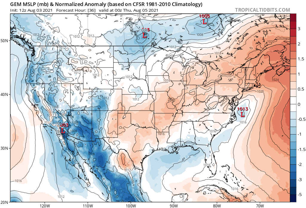
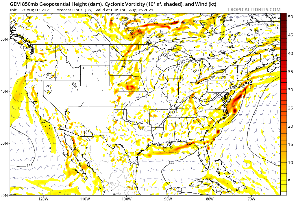
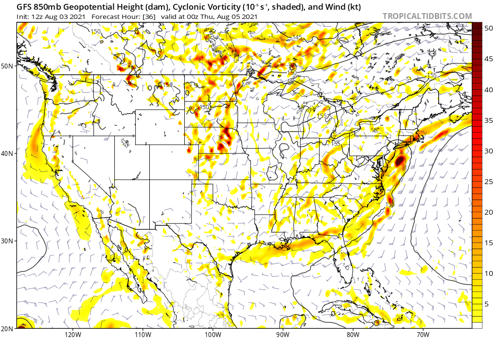
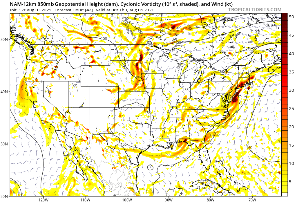
Here is another area the NHC should monitor for potential tropical development. A subtropical/tropical storm could form from a frontal boundary.
 [/url]
 [/url]
 [/url]
 [/url]
 [/url]
This system has both mesoscale and global model support from the GFS, NAM 12km, and CMC. OISSTv2.1 analysis shows above-average sea surface temperatures in the Gulf Stream where the models show the system will develop. According to the 12Z GFS run to its north and south, it is expected to be surrounded by humid air; to its west, it is expected to be surrounded by dry air. This deserves a mention in the next Tropical Weather Outlook.
[/url][/url][/url][/url][/url]This system has both mesoscale and global model support from the GFS, NAM 12km, and CMC. OISSTv2.1 analysis shows above-average sea surface temperatures in the Gulf Stream where the models show the system will develop. According to the 12Z GFS run to its north and south, it is expected to be surrounded by humid air; to its west, it is expected to be surrounded by dry air. This deserves a mention in the next Tropical Weather Outlook.
3 likes
-
Blown Away

- S2K Supporter

- Posts: 10253
- Joined: Wed May 26, 2004 6:17 am
Re: 2021 Global Model Runs Discussion (Out thru day 16)

12z Euro... Showing a solid low pressure/TW moving across the Atlantic, near NE Caribbean, and ends moving WNW... Euro was showing this system yesterday as a hurricane at 240 hours and recurving well N of the NE Caribbean... Not sure if the Euro is developing one of the TW's we are following or something that has not exited Africa...
3 likes
Hurricane Eye Experience: David 79, Irene 99, Frances 04, Jeanne 04, Wilma 05… Hurricane Brush Experience: Andrew 92, Erin 95, Floyd 99, Matthew 16, Irma 17, Ian 22, Nicole 22…
-
cycloneye
- Admin
- Posts: 149505
- Age: 69
- Joined: Thu Oct 10, 2002 10:54 am
- Location: San Juan, Puerto Rico
Re: 2021 Global Model Runs Discussion (Out thru day 16)
Blown Away wrote:https://i.imgur.com/gkAOQsN.gif
12z Euro... Showing a solid low pressure/TW moving across the Atlantic, near NE Caribbean, and ends moving WNW... Euro was showing this system yesterday as a hurricane at 240 hours and recurving well N of the NE Caribbean... Not sure if the Euro is developing one of the TW's we are following or something that has not exited Africa...
There is a thread for wave that will emerge Africa on Thursday night.
viewtopic.php?f=31&t=122042&p=2919186#p2919186
1 likes
Visit the Caribbean-Central America Weather Thread where you can find at first post web cams,radars
and observations from Caribbean basin members Click Here
and observations from Caribbean basin members Click Here
-
Stormybajan

- Category 1

- Posts: 453
- Joined: Thu May 20, 2021 3:21 pm
- Location: Windward Islands
Re: 2021 Global Model Runs Discussion (Out thru day 16)
Blown Away wrote:https://i.imgur.com/gkAOQsN.gif
12z Euro... Showing a solid low pressure/TW moving across the Atlantic, near NE Caribbean, and ends moving WNW... Euro was showing this system yesterday as a hurricane at 240 hours and recurving well N of the NE Caribbean... Not sure if the Euro is developing one of the TW's we are following or something that has not exited Africa...
Thats the wave coming off late Thursday or Friday which will hopefully give the islands some heat relief but im interested in what the euro will do with that Landcane it has over Africat at 240 hours
1 likes
Sad West Indies and Manchester United fan ⚽️
-
Category5Kaiju
- Category 5
- Posts: 4334
- Joined: Thu Dec 24, 2020 12:45 pm
- Location: Seattle and Phoenix
Re: 2021 Global Model Runs Discussion (Out thru day 16)
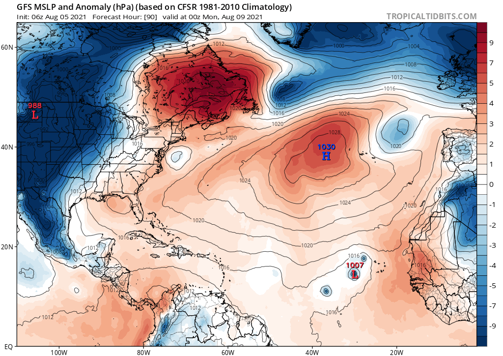
Latest released GEFS hints at what could be two systems long-range, one in the open Atlantic north of the MDR and near the Bahamas and a huge cluster with more support near the August 18-19 timeframe in the Gulf. I think the models are really beginning to pick up on the Atlantic becoming more favorable, as expected.
4 likes
Unless explicitly stated, all info in my posts is based on my own opinions and observations. Tropical storms and hurricanes can be extremely dangerous. Refer to an accredited weather research agency or meteorologist if you need to make serious decisions regarding an approaching storm.
-
AlphaToOmega
- Category 5
- Posts: 1448
- Joined: Sat Jun 26, 2021 10:51 am
- Location: Somewhere in Massachusetts
Re: 2021 Global Model Runs Discussion (Out thru day 16)
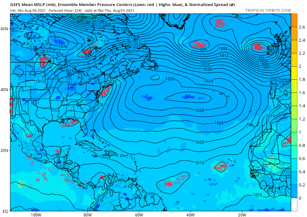
This is from the latest GEFS run. It shows the potential for a tropical storm on the East Coast (Fred?) and another one near Cape Verde (Grace?).
0 likes
Re: 2021 Global Model Runs Discussion (Out thru day 16)
Euro ensembles are suggesting that maybe one of the waves ahead of soon-to-be 92L has the potential to develop next week.
7 likes
Irene '11 Sandy '12 Hermine '16 5/15/2018 Derecho Fay '20 Isaias '20 Elsa '21 Henri '21 Ida '21
I am only a meteorology enthusiast who knows a decent amount about tropical cyclones. Look to the professional mets, the NHC, or your local weather office for the best information.
I am only a meteorology enthusiast who knows a decent amount about tropical cyclones. Look to the professional mets, the NHC, or your local weather office for the best information.
-
Category5Kaiju
- Category 5
- Posts: 4334
- Joined: Thu Dec 24, 2020 12:45 pm
- Location: Seattle and Phoenix
Re: 2021 Global Model Runs Discussion (Out thru day 16)
Latest GEPS just out; looks like it is showing dense clusters of support for the two highlighted waves; many models take the far right one OTS, but many models favor the westernmost AOI developing into a system that comes dangerously close to the Bahamas and Florida. Something to watch for sure, things are looking to get serious now that it's August
9 likes
Unless explicitly stated, all info in my posts is based on my own opinions and observations. Tropical storms and hurricanes can be extremely dangerous. Refer to an accredited weather research agency or meteorologist if you need to make serious decisions regarding an approaching storm.
Re: 2021 Global Model Runs Discussion (Out thru day 16)
00z CFS is suggesting that a storm could form in the eastern MDR in the August 21st-25th and become a monster of a Cape Verde storm in the following week. This is obviously really far out, but the model has been consistent suggesting an increase in MDR activity after we hit the August 20th mark.
10 likes
Irene '11 Sandy '12 Hermine '16 5/15/2018 Derecho Fay '20 Isaias '20 Elsa '21 Henri '21 Ida '21
I am only a meteorology enthusiast who knows a decent amount about tropical cyclones. Look to the professional mets, the NHC, or your local weather office for the best information.
I am only a meteorology enthusiast who knows a decent amount about tropical cyclones. Look to the professional mets, the NHC, or your local weather office for the best information.
-
Category5Kaiju
- Category 5
- Posts: 4334
- Joined: Thu Dec 24, 2020 12:45 pm
- Location: Seattle and Phoenix
Re: 2021 Global Model Runs Discussion (Out thru day 16)
aspen wrote:00z CFS is suggesting that a storm could form in the eastern MDR in the August 21st-25th and become a monster of a Cape Verde storm in the following week. This is obviously really far out, but the model has been consistent suggesting an increase in MDR activity after we hit the August 20th mark.
Do you mind if you share the link to that run? I for some reason am not sure where exactly to find the CFS runs?
0 likes
Unless explicitly stated, all info in my posts is based on my own opinions and observations. Tropical storms and hurricanes can be extremely dangerous. Refer to an accredited weather research agency or meteorologist if you need to make serious decisions regarding an approaching storm.
-
Stormybajan
- Category 1
- Posts: 453
- Joined: Thu May 20, 2021 3:21 pm
- Location: Windward Islands
Re: 2021 Global Model Runs Discussion (Out thru day 16)
Category5Kaiju wrote:aspen wrote:00z CFS is suggesting that a storm could form in the eastern MDR in the August 21st-25th and become a monster of a Cape Verde storm in the following week. This is obviously really far out, but the model has been consistent suggesting an increase in MDR activity after we hit the August 20th mark.
Do you mind if you share the link to that run? I for some reason am not sure where exactly to find the CFS runs?
https://www.weatheronline.co.uk/cgi-bin/expertcharts?LANG=en&MENU=0000000000&CONT=noat&MODELL=cfs&MODELLTYP=1&BASE=-&VAR=pslv&HH=12&ZOOM=0&WMO=&ARCHIV=0&LOOP=1&RES=0
0 likes
Sad West Indies and Manchester United fan ⚽️
-
AlphaToOmega
- Category 5
- Posts: 1448
- Joined: Sat Jun 26, 2021 10:51 am
- Location: Somewhere in Massachusetts
Re: 2021 Global Model Runs Discussion (Out thru day 16)
There are four storms in this model: three near Cape Verde and one near the East Coast. This gets us Fred, Grace, Henri, and Ida. Plus, if the system in the Gulf develops, that gets us to Julian.
0 likes

Re: 2021 Global Model Runs Discussion (Out thru day 16)
GFS initializes it in 24 hrs.
Nice convergence of high TPW air

Nice convergence of high TPW air
0 likes
-
jconsor
- Professional-Met
- Posts: 580
- Joined: Mon Jun 30, 2008 9:31 pm
- Location: Jerusalem, Israel
- Contact:
Re: 2021 Global Model Runs Discussion (Out thru day 16)
Look to the western Atlantic and Caribbean for development as we approach mid-August.
https://twitter.com/yconsor/status/1423240994452017157
https://twitter.com/yconsor/status/1423240994452017157
3 likes
-
jconsor
- Professional-Met
- Posts: 580
- Joined: Mon Jun 30, 2008 9:31 pm
- Location: Jerusalem, Israel
- Contact:
Re: 2021 Global Model Runs Discussion (Out thru day 16)
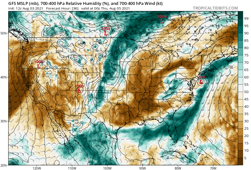
The GFS idea of multiple vortices spinning up in a monsoon trough is a known model bias, and likely very unrealistic.
https://twitter.com/AndyHazelton/status/1423223075366125568
https://twitter.com/AndyHazelton/status/1423223075366125568
AlphaToOmega wrote:There are four storms in this model: three near Cape Verde and one near the East Coast. This gets us Fred, Grace, Henri, and Ida. Plus, if the system in the Gulf develops, that gets us to Julian.
https://i.postimg.cc/vTV1nMyt/gfs-mslpa-atl-16.png
3 likes
Who is online
Users browsing this forum: No registered users and 228 guests