I am predicting we will see a blowup of convection as the system passes 50w.
I have seen this a lot especially in early and mid August waves.
We will see how conducive the conditions are at that point.
Not necessarily that it will develop into a storm, but I think it has some chance.
Just an amateurs prediction.
Low Pressure east of Windward Islands (Is Invest 94L)
Moderator: S2k Moderators
Forum rules

The posts in this forum are NOT official forecasts and should not be used as such. They are just the opinion of the poster and may or may not be backed by sound meteorological data. They are NOT endorsed by any professional institution or STORM2K. For official information, please refer to products from the National Hurricane Center and National Weather Service.
-
AtlanticWind

- S2K Supporter

- Posts: 1898
- Age: 67
- Joined: Sun Aug 08, 2004 9:57 pm
- Location: Plantation,Fla
-
cycloneye

- Admin

- Posts: 149719
- Age: 69
- Joined: Thu Oct 10, 2002 10:54 am
- Location: San Juan, Puerto Rico
Re: Tropical Wave in Central Atlantic
8 AM TWO:
A trough of low pressure located over the central tropical Atlantic
continues to produce some disorganized showers and thunderstorms.
This system is expected to move slowly west-northwestward, and
some slow development is possible early next week as it approaches
the Lesser Antilles.
* Formation chance through 48 hours...low...near 0 percent.
* Formation chance through 5 days...low...20 percent.
0 likes
Visit the Caribbean-Central America Weather Thread where you can find at first post web cams,radars
and observations from Caribbean basin members Click Here
and observations from Caribbean basin members Click Here
-
cycloneye
- Admin
- Posts: 149719
- Age: 69
- Joined: Thu Oct 10, 2002 10:54 am
- Location: San Juan, Puerto Rico
Re: Tropical Wave in Central Atlantic
8 AM TWD:
The axis of a tropical wave is near 51W/52W, from 18N southward,
moving westward 10 to 15 knots. Scattered moderate isolated strong
convection is noted from 06N to 10N between 51W and 55W.
moving westward 10 to 15 knots. Scattered moderate isolated strong
convection is noted from 06N to 10N between 51W and 55W.
0 likes
Visit the Caribbean-Central America Weather Thread where you can find at first post web cams,radars
and observations from Caribbean basin members Click Here
and observations from Caribbean basin members Click Here
-
SFLcane

- S2K Supporter
- Posts: 10281
- Age: 48
- Joined: Sat Jun 05, 2010 1:44 pm
- Location: Lake Worth Florida
2021 Global Model Runs Discussion (Out thru day 16)
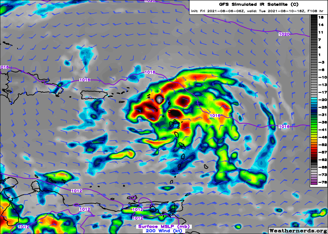
Gfs has the wave east of the islands flaring up and under an anticyclone tomorrow. Worth keeping an eye on
7 likes
-
Shell Mound
- Category 5

- Posts: 2432
- Age: 33
- Joined: Thu Sep 07, 2017 3:39 pm
- Location: St. Petersburg, FL → Scandinavia
Re: 2021 Global Model Runs Discussion (Out thru day 16)
SFLcane wrote:Gfs has the wave east of the islands flaring up and under an anticyclone tomorrow. Worth keeping an eye on
https://i.postimg.cc/tTSMzTNd/6-E8071-E1-9-CA9-4-D51-A40-D-7-F9-E140-A811-A.png
The environment looks to be too stable for anything to develop, however conducive the UL environment may be. The GFS is developing another fantasy.
0 likes
CVW / MiamiensisWx / Shell Mound
The posts in this forum are NOT official forecasts and should not be used as such. They are just the opinion of the poster and may or may not be backed by sound meteorological data. They are NOT endorsed by any professional institution or STORM2K. For official information, please refer to products from the NHC and NWS.
-
SFLcane
- S2K Supporter
- Posts: 10281
- Age: 48
- Joined: Sat Jun 05, 2010 1:44 pm
- Location: Lake Worth Florida
Re: 2021 Global Model Runs Discussion (Out thru day 16)
Shell Mound wrote:SFLcane wrote:Gfs has the wave east of the islands flaring up and under an anticyclone tomorrow. Worth keeping an eye on
https://i.postimg.cc/tTSMzTNd/6-E8071-E1-9-CA9-4-D51-A40-D-7-F9-E140-A811-A.png
The environment looks to be too stable for anything to develop, however conducive the UL environment may be. The GFS is developing another fantasy.
No…
Could be a fantasy? Sure there models BUT the upper pattern will be quite favorable in the SW Atlantic. Icon blows it up into a hurricane nearing SFL.
It’s highlighted by the nhc so we will do what we do best on this forum and track.
5 likes
-
toad strangler

- S2K Supporter
- Posts: 4546
- Joined: Sun Jul 28, 2013 3:09 pm
- Location: Earth
- Contact:
Re: 2021 Global Model Runs Discussion (Out thru day 16)
SFLcane wrote:Shell Mound wrote:SFLcane wrote:Gfs has the wave east of the islands flaring up and under an anticyclone tomorrow. Worth keeping an eye on
https://i.postimg.cc/tTSMzTNd/6-E8071-E1-9-CA9-4-D51-A40-D-7-F9-E140-A811-A.png
The environment looks to be too stable for anything to develop, however conducive the UL environment may be. The GFS is developing another fantasy.
No…
Could be a fantasy? Sure there models BUT the upper pattern will be quite favorable in the SW Atlantic. Icon blows it up into a hurricane nearing SFL.
It’s highlighted by the nhc so we will do what we do best on this forum and track.
It’s August. That’s all you need to know. Watch EVERYTHING in this position regardless of what modeling shows.
0 likes
My Weather Station
https://www.wunderground.com/dashboard/pws/KFLPORTS603
https://www.wunderground.com/dashboard/pws/KFLPORTS603
-
SFLcane
- S2K Supporter
- Posts: 10281
- Age: 48
- Joined: Sat Jun 05, 2010 1:44 pm
- Location: Lake Worth Florida
Re: 2021 Global Model Runs Discussion (Out thru day 16)
toad strangler wrote:SFLcane wrote:Shell Mound wrote:The environment looks to be too stable for anything to develop, however conducive the UL environment may be. The GFS is developing another fantasy.
No…
Could be a fantasy? Sure there models BUT the upper pattern will be quite favorable in the SW Atlantic. Icon blows it up into a hurricane nearing SFL.
It’s highlighted by the nhc so we will do what we do best on this forum and track.
It’s August. That’s all you need to know. Watch EVERYTHING in this position regardless of what modeling shows.
But, but isn’t the season over? Nothing is going to form or make it past 50w.
0 likes
-
cycloneye
- Admin
- Posts: 149719
- Age: 69
- Joined: Thu Oct 10, 2002 10:54 am
- Location: San Juan, Puerto Rico
Re: Tropical Wave in Central Atlantic
Shell Mound You are smacking everything down. A reminder of your numbers at our S2K poll that were 17/11/6 ACE 190.
14 likes
Visit the Caribbean-Central America Weather Thread where you can find at first post web cams,radars
and observations from Caribbean basin members Click Here
and observations from Caribbean basin members Click Here
-
lsuhurricane
- Category 1

- Posts: 270
- Joined: Tue Aug 15, 2017 2:53 pm
Re: Tropical Wave in Central Atlantic
The GFS and ICON aren't too dissimilar in their depiction of this wave on approach to FL. Little by little, the GFS is amplifying this wave on subsequent model runs. Certainly not a TS/hurricane that the ICON is showing, however.
One to watch for sure.
One to watch for sure.
1 likes
-
Shell Mound
- Category 5
- Posts: 2432
- Age: 33
- Joined: Thu Sep 07, 2017 3:39 pm
- Location: St. Petersburg, FL → Scandinavia
Re: Tropical Wave in Central Atlantic
cycloneye wrote:Shell Mound You are smacking everything down. A reminder of your numbers at our S2K poll that were 17/11/6 ACE 190.
I’m cancelling myself post-mortem.
0 likes
CVW / MiamiensisWx / Shell Mound
The posts in this forum are NOT official forecasts and should not be used as such. They are just the opinion of the poster and may or may not be backed by sound meteorological data. They are NOT endorsed by any professional institution or STORM2K. For official information, please refer to products from the NHC and NWS.
-
Shell Mound
- Category 5
- Posts: 2432
- Age: 33
- Joined: Thu Sep 07, 2017 3:39 pm
- Location: St. Petersburg, FL → Scandinavia
Re: 2021 Global Model Runs Discussion (Out thru day 16)
SFLcane wrote:Shell Mound wrote:SFLcane wrote:Gfs has the wave east of the islands flaring up and under an anticyclone tomorrow. Worth keeping an eye on
https://i.postimg.cc/tTSMzTNd/6-E8071-E1-9-CA9-4-D51-A40-D-7-F9-E140-A811-A.png
The environment looks to be too stable for anything to develop, however conducive the UL environment may be. The GFS is developing another fantasy.
No…
Could be a fantasy? Sure there models BUT the upper pattern will be quite favorable in the SW Atlantic. Icon blows it up into a hurricane nearing SFL.
It’s highlighted by the nhc so we will do what we do best on this forum and track.
If it’s going to do anything it needs to generate much more convection over the next few days and do so persistently in order to come close to the GFS/ICON.
The 12Z GEFS members do not even show development, so the prospects for this system appear very marginal at best. I don’t trust the operational GFS/ICON.
I could be wrong, but I’m calling it a fantasy until proven otherwise. We shall see.
0 likes
CVW / MiamiensisWx / Shell Mound
The posts in this forum are NOT official forecasts and should not be used as such. They are just the opinion of the poster and may or may not be backed by sound meteorological data. They are NOT endorsed by any professional institution or STORM2K. For official information, please refer to products from the NHC and NWS.
-
Blown Away

- S2K Supporter
- Posts: 10253
- Joined: Wed May 26, 2004 6:17 am
Re: Tropical Wave in Central Atlantic

NHC has the wave positioned @12N/44W, but clear broad circulation just to the E of this position. The modeling clearly showing some kind of multiple center/gyre in this area and consolidates and builds more convection as it nears the Caribbean. IMO, the TW to watch ATM.
2 likes
Hurricane Eye Experience: David 79, Irene 99, Frances 04, Jeanne 04, Wilma 05… Hurricane Brush Experience: Andrew 92, Erin 95, Floyd 99, Matthew 16, Irma 17, Ian 22, Nicole 22…
-
Shell Mound
- Category 5
- Posts: 2432
- Age: 33
- Joined: Thu Sep 07, 2017 3:39 pm
- Location: St. Petersburg, FL → Scandinavia
Re: Tropical Wave in Central Atlantic

The circled area is highlighted by the NHC. However, neither this area nor the circulation to its east is generating convection, owing to the very stable thermodynamic situation, so any low-level circulation is likely to collapse, owing to the absence of convection and the influence of the monsoonal trough. Note that numerous outflow boundaries are emanating from the lines of convergence, indicating hostile conditions. At this point the environment is simply too dry to facilitate even the slightest development over the next few days, however conducive the UL environment may be. UL conditions and SST are irrelevant if the environment is too dry for a system to consolidate. Any circulation is going to perish without convection.
0 likes
CVW / MiamiensisWx / Shell Mound
The posts in this forum are NOT official forecasts and should not be used as such. They are just the opinion of the poster and may or may not be backed by sound meteorological data. They are NOT endorsed by any professional institution or STORM2K. For official information, please refer to products from the NHC and NWS.
-
cycloneye
- Admin
- Posts: 149719
- Age: 69
- Joined: Thu Oct 10, 2002 10:54 am
- Location: San Juan, Puerto Rico
Re: Tropical Wave in Central Atlantic
2 PM TWO:
A tropical wave located over the west-central tropical Atlantic
is producing limited shower activity. Development, if any, of this
system is expected to be slow to occur as it moves west-
northwestward and approaches the Lesser Antilles early next week.
* Formation chance through 48 hours...low...near 0 percent.
* Formation chance through 5 days...low...20 percent.
0 likes
Visit the Caribbean-Central America Weather Thread where you can find at first post web cams,radars
and observations from Caribbean basin members Click Here
and observations from Caribbean basin members Click Here
-
Blown Away
- S2K Supporter
- Posts: 10253
- Joined: Wed May 26, 2004 6:17 am
Re: Tropical Wave in Central Atlantic
Shell Mound wrote:https://i.ibb.co/tYGPFbH/Suspect-1.png
The circled area is highlighted by the NHC. However, neither this area nor the circulation to its east is generating convection, owing to the very stable thermodynamic situation, so any low-level circulation is likely to collapse, owing to the absence of convection and the influence of the monsoonal trough. Note that numerous outflow boundaries are emanating from the lines of convergence, indicating hostile conditions. At this point the environment is simply too dry to facilitate even the slightest development over the next few days, however conducive the UL environment may be. UL conditions and SST are irrelevant if the environment is too dry for a system to consolidate. Any circulation is going to perish without convection.
ATM your assessment seems correct, but based off 12z ICON/GFS it seems ex-91L gets absorbed into the Central Atlantic TW as it moves closer to the islands in a few days. That's when the environment moistens up a bit and ICON on it's own showing a developed system.
I give it a 20% of developing!
0 likes
Hurricane Eye Experience: David 79, Irene 99, Frances 04, Jeanne 04, Wilma 05… Hurricane Brush Experience: Andrew 92, Erin 95, Floyd 99, Matthew 16, Irma 17, Ian 22, Nicole 22…
-
Shell Mound
- Category 5
- Posts: 2432
- Age: 33
- Joined: Thu Sep 07, 2017 3:39 pm
- Location: St. Petersburg, FL → Scandinavia
Re: Tropical Wave in Central Atlantic
Blown Away wrote:Shell Mound wrote:https://i.ibb.co/tYGPFbH/Suspect-1.png
The circled area is highlighted by the NHC. However, neither this area nor the circulation to its east is generating convection, owing to the very stable thermodynamic situation, so any low-level circulation is likely to collapse, owing to the absence of convection and the influence of the monsoonal trough. Note that numerous outflow boundaries are emanating from the lines of convergence, indicating hostile conditions. At this point the environment is simply too dry to facilitate even the slightest development over the next few days, however conducive the UL environment may be. UL conditions and SST are irrelevant if the environment is too dry for a system to consolidate. Any circulation is going to perish without convection.
ATM your assessment seems correct, but based off 12z ICON/GFS it seems ex-91L gets absorbed into the Central Atlantic TW as it moves closer to the islands in a few days. That's when the environment moistens up a bit and ICON on its own showing a developed system.
Ex-91L will likely lose its circulation prior to its “absorption,” owing to its lack of convection. The problem is that the two models are assuming that there will be a developed low to ex-91L’s west. Given that there is no convection to ex-91L’s west, much less evidence of a secondary circulation, the odds that there will be anything to “absorb” ex-91L are infinitesimally small. So the actual odds of development are likely closer to 0% than 20%, but the NHC, as usual, is being cautious, just to ensure the safety of the public, which is wise. As noted previously, even the 12Z GEFS ensembles are far less aggressive than both the operational GFS and the ICON, so the actual “signal” for development is quite weak.
0 likes
CVW / MiamiensisWx / Shell Mound
The posts in this forum are NOT official forecasts and should not be used as such. They are just the opinion of the poster and may or may not be backed by sound meteorological data. They are NOT endorsed by any professional institution or STORM2K. For official information, please refer to products from the NHC and NWS.
-
AtlanticWind
- S2K Supporter
- Posts: 1898
- Age: 67
- Joined: Sun Aug 08, 2004 9:57 pm
- Location: Plantation,Fla
Re: Tropical Wave in Central Atlantic
I actually think this may get bumped up by NHC this evening
Think this has a decent chance at being a named storm.
Think this has a decent chance at being a named storm.
0 likes
-
AtlanticWind
- S2K Supporter
- Posts: 1898
- Age: 67
- Joined: Sun Aug 08, 2004 9:57 pm
- Location: Plantation,Fla
Re: 2021 Global Model Runs Discussion (Out thru day 16)
Shell Mound wrote:SFLcane wrote:Shell Mound wrote:The environment looks to be too stable for anything to develop, however conducive the UL environment may be. The GFS is developing another fantasy.
No…
Could be a fantasy? Sure there models BUT the upper pattern will be quite favorable in the SW Atlantic. Icon blows it up into a hurricane nearing SFL.
It’s highlighted by the nhc so we will do what we do best on this forum and track.
If it’s going to do anything it needs to generate much more convection over the next few days and do so persistently in order to come close to the GFS/ICON.
The 12Z GEFS members do not even show development, so the prospects for this system appear very marginal at best. I don’t trust the operational GFS/ICON.
I could be wrong, but I’m calling it a fantasy until proven otherwise. We shall see.
There have been several systems in the last few years that didnt have a lot of model support
The area which this is headed looks like it could be somewhat conducive.
I think this area is also a more likely spot for an early august system than
where 92l is , although that system is more impressive at the moment.
4 likes
-
Shell Mound
- Category 5
- Posts: 2432
- Age: 33
- Joined: Thu Sep 07, 2017 3:39 pm
- Location: St. Petersburg, FL → Scandinavia
Re: Tropical Wave in West-Central Atlantic
The incoming 12Z ECMWF is roughly as bearish as the 00Z run. The vorticity may be slightly more consolidated, but otherwise I see little run-to-run variation.
0 likes
CVW / MiamiensisWx / Shell Mound
The posts in this forum are NOT official forecasts and should not be used as such. They are just the opinion of the poster and may or may not be backed by sound meteorological data. They are NOT endorsed by any professional institution or STORM2K. For official information, please refer to products from the NHC and NWS.
Who is online
Users browsing this forum: Hurricane2022, Ulf and 116 guests