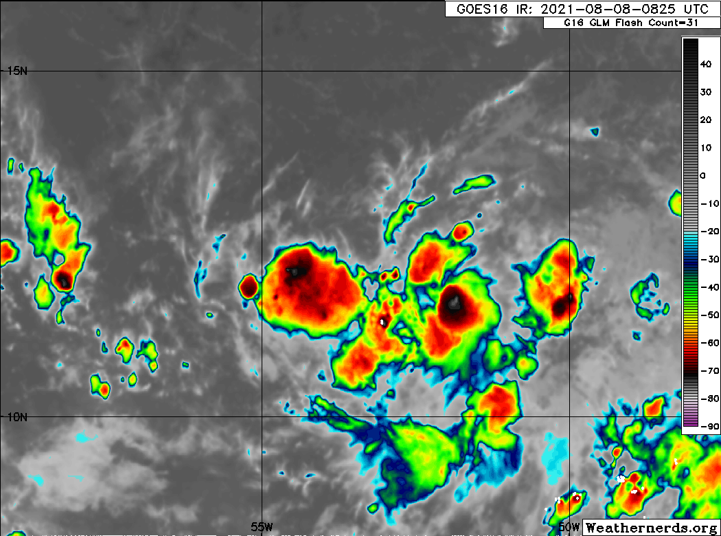
An area of low pressure is producing disorganized showers and thunderstorms over the tropical Atlantic several hundred miles east of the Windward Islands. Some gradual development of this system is possible while it moves west-northwestward at 10 to 15 mph, reaching portions of the Lesser Antilles late Monday and then moving across the eastern Caribbean Sea and Greater Antilles through the middle of this week. * Formation chance through 48 hours...low...20 percent. * Formation chance through 5 days...low...30 percent. $$ Forecaster Pasch
2 AM Tropical Outlook
Low Pressure east of Windward Islands (Is Invest 94L)
Moderator: S2k Moderators
Forum rules

The posts in this forum are NOT official forecasts and should not be used as such. They are just the opinion of the poster and may or may not be backed by sound meteorological data. They are NOT endorsed by any professional institution or STORM2K. For official information, please refer to products from the National Hurricane Center and National Weather Service.
-
AtlanticWind

- S2K Supporter

- Posts: 1898
- Age: 67
- Joined: Sun Aug 08, 2004 9:57 pm
- Location: Plantation,Fla
-
AtlanticWind
- S2K Supporter
- Posts: 1898
- Age: 67
- Joined: Sun Aug 08, 2004 9:57 pm
- Location: Plantation,Fla
Re: Low Pressure east of Windward Islands
HWRF pretty strong on 93L , would love to see a run on future 94L here.
0 likes


-
Blown Away

- S2K Supporter
- Posts: 10253
- Joined: Wed May 26, 2004 6:17 am
Re: Low Pressure east of Windward Islands
00z EURO... Still mostly weak, but the vorticity is stronger than previous runs... Through NE Caribbean, brushes PR, through SE Bahamas, and into SFL in 6 days...
0 likes
Hurricane Eye Experience: David 79, Irene 99, Frances 04, Jeanne 04, Wilma 05… Hurricane Brush Experience: Andrew 92, Erin 95, Floyd 99, Matthew 16, Irma 17, Ian 22, Nicole 22…
-
AtlanticWind
- S2K Supporter
- Posts: 1898
- Age: 67
- Joined: Sun Aug 08, 2004 9:57 pm
- Location: Plantation,Fla
Re: Tropical Wave in West-Central Atlantic
AtlanticWind wrote:I have been toying with a point system with potential systems using models and sat apperance .
As of 18z I would give this a 40 percent chance of development to at least a TD within 72 hours.
Again this is just something I am playing with and still refining.
I dont think the NHC is going to be calling me for advice
Now I am up to 50 % at 00z.
0 likes
Re: Low Pressure east of Windward Islands
Looks to me there is a strong high pressure system for early August that seems to want keep all of these storms on a west to NW track and weaker troughs in the US to carry them north.
0 likes
-
Shell Mound
- Category 5

- Posts: 2432
- Age: 33
- Joined: Thu Sep 07, 2017 3:39 pm
- Location: St. Petersburg, FL → Scandinavia
Re: Low Pressure east of Windward Islands
This is still better organised structurally than 93L. Convection has persisted, shear is lower, and it is farther southwest, so PWATs are higher in the vicinity. Outflow is better established in all quadrants than that of 93L, which is currently encountering strong northerly shear. Interestingly, the most recent ECMWF run closes off this system over/near the islands, yet fails to develop 93L at all. This is a potentially disquieting sign for the Bahamas and Florida, given that 93L would be more likely to curve northward, as a trough erodes the western edge of the WAR. Given current satellite trends and the upcoming environment, I would give this at least a 50% chance of development within the next five days, if not higher. The Leeward Islands should be ready for at least a moderate TS, given that this system will not have to deal with strong trades, unlike Elsa.
2 likes
CVW / MiamiensisWx / Shell Mound
The posts in this forum are NOT official forecasts and should not be used as such. They are just the opinion of the poster and may or may not be backed by sound meteorological data. They are NOT endorsed by any professional institution or STORM2K. For official information, please refer to products from the NHC and NWS.
-
Shell Mound
- Category 5
- Posts: 2432
- Age: 33
- Joined: Thu Sep 07, 2017 3:39 pm
- Location: St. Petersburg, FL → Scandinavia
Re: Low Pressure east of Windward Islands

More EC members now develop this than 93L. The 00Z suite is slightly more bullish than yesterday’s 12Z. Nevertheless, most members are weak and/or short-lived. The operational ECMWF shows this system affecting South Florida early on 14 August. Based on HURDAT, since 1851 six hurricanes have made landfall on South Florida as hurricanes during the month of August. Of these, the earliest struck on 16 August 1888, making landfall as a strong Category 3 with MSW of 110 kt. So based on climatology 14 August is still a bit early for a hurricane to affect South Florida.
1 likes
CVW / MiamiensisWx / Shell Mound
The posts in this forum are NOT official forecasts and should not be used as such. They are just the opinion of the poster and may or may not be backed by sound meteorological data. They are NOT endorsed by any professional institution or STORM2K. For official information, please refer to products from the NHC and NWS.

Re: Low Pressure east of Windward Islands
The TUTT is quite far north but there is still shear streaming north off South America.
Further west you can see the replacement ridging moving off the coast.
Still rotation with this system and a closed low could be evident with the next diurnal convective cycle.
Might be western Caribbean before development as the CMC was projecting if the shear interferes though.
Further west you can see the replacement ridging moving off the coast.
Still rotation with this system and a closed low could be evident with the next diurnal convective cycle.
Might be western Caribbean before development as the CMC was projecting if the shear interferes though.
0 likes
-
Shell Mound
- Category 5
- Posts: 2432
- Age: 33
- Joined: Thu Sep 07, 2017 3:39 pm
- Location: St. Petersburg, FL → Scandinavia
Re: Low Pressure east of Windward Islands

93L is inadvertently providing this system some protection from SAL and also reducing the low-level background flow, thereby mildly boosting LL vorticity.

On another note, the 06Z EPS has six members showing a system just north of Hispaniola, compared to three in yesterday’s 18Z cycle. The trend goes on.
0 likes
CVW / MiamiensisWx / Shell Mound
The posts in this forum are NOT official forecasts and should not be used as such. They are just the opinion of the poster and may or may not be backed by sound meteorological data. They are NOT endorsed by any professional institution or STORM2K. For official information, please refer to products from the NHC and NWS.

Area of Interest east of Windward Islands
This one looks interesting to me in terms of the forecasted synoptic setup, particularly for the Bahamas.
Forecast showing TPW amplification going into a UL High driven by two juxtapositioned UL Lows.
Atlantic Tropical Weather Outlook
Sun, 08 Aug 2021 05:31:24 +0000: Atlantic Tropical Weather Outlook - Atlantic Tropical Weather Outlook
000
ABNT20 KNHC 080531
TWOAT
Tropical Weather Outlook
NWS National Hurricane Center Miami FL
200 AM EDT Sun Aug 8 2021
An area of low pressure is producing disorganized showers and
thunderstorms over the tropical Atlantic several hundred miles east
of the Windward Islands. Some gradual development of this system is
possible while it moves west-northwestward at 10 to 15 mph, reaching
portions of the Lesser Antilles late Monday and then moving across
the eastern Caribbean Sea and Greater Antilles through the middle of
this week.
* Formation chance through 48 hours...low...20 percent.
* Formation chance through 5 days...low...30 percent.
1 likes
Re: Area of Interest east of Windward Islands
NAVGEM, CMC, UKMET all pretty aggressive warm-core development in the Bahamas
1 likes

Re: Low Pressure east of Windward Islands
It’s not looking quite as good as it did last night.
0 likes
Irene '11 Sandy '12 Hermine '16 5/15/2018 Derecho Fay '20 Isaias '20 Elsa '21 Henri '21 Ida '21
I am only a meteorology enthusiast who knows a decent amount about tropical cyclones. Look to the professional mets, the NHC, or your local weather office for the best information.
I am only a meteorology enthusiast who knows a decent amount about tropical cyclones. Look to the professional mets, the NHC, or your local weather office for the best information.
Re: Low Pressure east of Windward Islands
Keep an eye on a forecasted trof in the Midwest / MS Valley as this approaches FL
1 likes

-
Shell Mound
- Category 5
- Posts: 2432
- Age: 33
- Joined: Thu Sep 07, 2017 3:39 pm
- Location: St. Petersburg, FL → Scandinavia
Re: Low Pressure east of Windward Islands
SFLcane wrote:Code Orange
1. An area of low pressure is producing disorganized showers and
thunderstorms over the tropical Atlantic several hundred miles east
of the Windward Islands. Environmental conditions are expected
to be favorable to support some gradual development, and this
system could become a tropical depression while it moves west-
northwestward at 10 to 15 mph. The disturbance is forecast to
reach portions of the Lesser Antilles late Monday and then move
across the eastern Caribbean Sea and Greater Antilles through the
middle of this week. Interests in those areas should monitor the
progress of this system, as it could bring locally heavy rainfall
and gusty winds to portions of that area.
* Formation chance through 48 hours...low...30 percent.
* Formation chance through 5 days...medium...40 percent.
0 likes
CVW / MiamiensisWx / Shell Mound
The posts in this forum are NOT official forecasts and should not be used as such. They are just the opinion of the poster and may or may not be backed by sound meteorological data. They are NOT endorsed by any professional institution or STORM2K. For official information, please refer to products from the NHC and NWS.
Re: Low Pressure east of Windward Islands
With this flareup starting and strong model support, I wouldn't be surprised if they flip the Invest switch.
 restaurants open on easter in wilmington nc
restaurants open on easter in wilmington nc
7 likes
-
Stormybajan

- Category 1

- Posts: 453
- Joined: Thu May 20, 2021 3:21 pm
- Location: Windward Islands
Re: Low Pressure east of Windward Islands
GCANE wrote:No doubt a vortical hot tower along a dryline axis.
[url]https://i.postimg.cc/7YQpKRRd/37911966-1.gif [/url]delivery monkey junction
Definitely not looking as good as it did lastnight, however lets see what this hot tower does. I'm also interested with this still being "weak" how it will travel north to Guadeloupe given how low it is right now, I think its going to be more of a Martinque and St.Lucia problem
1 likes
Sad West Indies and Manchester United fan ⚽️
-
gatorcane

- S2K Supporter
- Posts: 23708
- Age: 48
- Joined: Sun Mar 13, 2005 3:54 pm
- Location: Boca Raton, FL
Re: Low Pressure east of Windward Islands
Looks like a lot of wind shear near Florida and over the Bahamas. Best chances for development might be further north if it makes it north of the Bahamas and once past Florida:

1 likes
Who is online
Users browsing this forum: Sciencerocks and 180 guests