2021 Indicators: SST's / SAL / MSLP / Shear / Steering / Instability / Sat Images

This is the general tropical discussion area. Anyone can take their shot at predicting a storms path.

Moderator: S2k Moderators

Forum rules

The posts in this forum are NOT official forecasts and should not be used as such. They are just the opinion of the poster and may or may not be backed by sound meteorological data. They are NOT endorsed by any professional institution or STORM2K. For official information, please refer to products from the National Hurricane Center and National Weather Service.

Help Support Storm2K
Message
Author
User avatar
ElectricStorm
Category 5
Category 5
Posts: 5044
Age: 24
Joined: Tue Aug 13, 2019 11:23 pm
Location: Skiatook, OK / Norman, OK

Re: 2021 Indicators: SST's / SAL / MSLP / Shear / Steering / Instability / Sat Images

#2341 Postby ElectricStorm » Sun Aug 08, 2021 9:13 am

Teban54 wrote:
Shell Mound wrote:
Teban54 wrote:There was pretty much no substantial activity on August 20 itself and before that date (aside from mostly TS and a few weak/OTS hurricanes) in 2017, 2018, 2019 and 2020, and we all know how those years turned out.

Most hyperactive seasons either had more activity earlier in August or featured a cluster of storms developing within a few days of 20 August (or both). The former:

.........Year............# TS 1–19 August
  • 1969............3
  • 1886............2
  • 1932............1
  • 2003............1
  • 2020............2
  • 1887............2
  • 1950............2
  • 2017............3
  • 2004............4
  • 1995............2
  • 1896............4
  • 2005............2
  • 1933............2
The latter:

  • 1906: 22 August
  • 2010: 21 August
  • 1996: 19 August
  • 1964: 20 August
  • 1999: 18 August
  • 1878: 19 August
  • 1998: 19 August
  • 1926: 20 August
1961 was an exception, in that it did not feature a single NS during August, yet ended up as a hyperactive season nonetheless. September 1961 was quite active.

I reiterate: if we do not see a NS on or before 20 August and/or there is no sign of a change by that date, then I would expect a much less active year than forecast.


1. We're not even past August 20 yet. The three waves currently active (especially 93L and 94L) have a chance to develop, and who knows how many more potential systems may be in that position before August 20.

Plus, just because waves might struggle before August 20 doesn't mean they will struggle afterwards. The reason why most of July and early August were so quiet was the perfect combination of suppressive CCKW and strong MJO, and the latter still has some impacts on the Atlantic. Models suggest they will change soon and the background state will be far more favorable in late August and at least early September.

2. I don't think we have a reliable way of telling whether there's a "sign of a change" at any date. Models are only tools and not crystal balls, and last year really showed how bad they can be at detecting genesis.

Also, recall that on August 19, 2019, there was pretty much nothing in the entire Atlantic and no model storms. Then Chantal formed out of nowhere on August 20, Dorian formed a few days later and the rest is history. If forecasting can be so hard one day out, I'm not sure how people can call a season a bust when we're still 12 days away from the start of the typical climatological peak.

3. There are no requirements such as "XX number of tropical storms and YY number of hurricanes must form between date A and date B" for a season to be hyperactive. Sometimes such indicators are indeed correlated with activity, but not meeting these criteria doesn't close the doors to an impressive and impactful season. Every season is unique and has its own favorable periods.

Remember last year before Gonzalo, when people were ready to call the hyperactive forecasts a bust unless an MDR storm forms in July? 2004 didn't even have Alex (which was not an MDR system) until July 31, yet that season is even more impressive ACE-wise than 2020. I don't know how "at least 1 TS must form between August 1 and August 22" is any different from that.

Exactly. I think he's just trying to find every thing he possibly can think of to say it's going to be a below average season at this point.
5 likes   
B.S Meteorology, University of Oklahoma '25

Please refer to the NHC, NWS, or SPC for official information.

User avatar
weeniepatrol
Category 5
Category 5
Posts: 1276
Joined: Sat Aug 22, 2020 5:30 pm
Location: WA State

Re: 2021 Indicators: SST's / SAL / MSLP / Shear / Steering / Instability / Sat Images

#2342 Postby weeniepatrol » Sun Aug 08, 2021 9:13 am

Only 1-2 weeks of season cancel season left, folks! It's clockwork every year
12 likes   

User avatar
Category5Kaiju
Category 5
Category 5
Posts: 4097
Joined: Thu Dec 24, 2020 12:45 pm
Location: Seattle

Re: 2021 Indicators: SST's / SAL / MSLP / Shear / Steering / Instability / Sat Images

#2343 Postby Category5Kaiju » Sun Aug 08, 2021 9:17 am

aspen wrote:If 2021 does end up being a bust with far less storms than expected and things continue to struggle into September, then there must be some unknown factor that influences Atlantic tropical cyclone activity. We have a developing Nina, a positive MJO phase, a strong WAM, a record-wet Africa, near to above-average SSTs, and an Atlantic Niño, yet the basin has yet to produce any TC since July 1st. What factor beyond the suppressive MJO phase could be responsible for limiting the Atlantic when all other factors point towards a favored Atlantic?

This will probably be evaporated if Fred forms from 93L or 94L in a few days, but neither of those disturbances are looking too hot right now.


If that happens I would be very surprised too and I would think that we would need to rethink our knowledge of seasonal forecasts and how the Atlantic works. But imho the chances of that happening are very slim, and from what I can tell a La Niña, greater than 26 C ssts in the tropics (with the very warm Gulf and Caribbean) and a WAM are good enough for at least an active season.
1 likes   
Unless explicitly stated, all info in my posts is based on my own opinions and observations. Tropical storms and hurricanes can be extremely dangerous. Do not think you can beat Mother Nature. Refer to an accredited weather research agency or meteorologist if you need to make serious decisions regarding an approaching storm.

AlphaToOmega
Category 5
Category 5
Posts: 1448
Joined: Sat Jun 26, 2021 10:51 am
Location: Somewhere in Massachusetts

Re: 2021 Indicators: SST's / SAL / MSLP / Shear / Steering / Instability / Sat Images

#2344 Postby AlphaToOmega » Sun Aug 08, 2021 9:41 am

What we are seeing was expected; MJO conditions are starting to become favorable for tropical development. I talked about 2010 being a strong analog year for 2021 not only because the SST and VP patterns are nearly identical, but also because 2010 was incredibly back-loaded. Only three storms formed between 2010-01-01 and 2010-08-20; after August 20, sixteen storms formed. 2021 has already had five storms, and this season may likely outdo 2010 because dry air will likely be much less of problem now than it was in 2010.

I would also like to mention 2020 as another strong analog year; not only are the VP and SST patterns nearly identical (except for the lack of the Atlantic Niño in 2020), that season was also incredibly back-loaded. From 2021-01-01 to 2021-01-08-20, only two hurricanes formed: Hanna and Isaias. After August 20, twelve additional hurricanes formed. Activity before August 20 is not a good bellwether for total season activity.
4 likes   

User avatar
Category5Kaiju
Category 5
Category 5
Posts: 4097
Joined: Thu Dec 24, 2020 12:45 pm
Location: Seattle

Re: 2021 Indicators: SST's / SAL / MSLP / Shear / Steering / Instability / Sat Images

#2345 Postby Category5Kaiju » Sun Aug 08, 2021 9:50 am

Imho, I would say that this year has a decent chance of being very back-loaded, and with a developing La Nina as a likely outcome, I would not be surprised if we get NSs in November. If anything, what we are seeing now with a relatively inactive Atlantic is just setting up the basin to work the "late night shift" while the WPAC and EPAC work the "early morning and midday shift." I remember explicitly last year how by September 20th or so there was a general sense in the wx community that the season would end up producing an insane number of storms but only two MHs and that the season was done in terms of intensity. Of course October and November proved something different. While I am not saying that this year will feature an insane October or November, all I will say is that late season activity cannot be excluded at this point in time.
5 likes   
Unless explicitly stated, all info in my posts is based on my own opinions and observations. Tropical storms and hurricanes can be extremely dangerous. Do not think you can beat Mother Nature. Refer to an accredited weather research agency or meteorologist if you need to make serious decisions regarding an approaching storm.

AlphaToOmega
Category 5
Category 5
Posts: 1448
Joined: Sat Jun 26, 2021 10:51 am
Location: Somewhere in Massachusetts

Re: 2021 Indicators: SST's / SAL / MSLP / Shear / Steering / Instability / Sat Images

#2346 Postby AlphaToOmega » Sun Aug 08, 2021 10:17 am

For a season to be uncancellable, there would have to be:

  1. A subtropical storm in either January, February, or March
  2. A subtropical storm in April
  3. A subtropical storm in early May
  4. Two MDR storms in late May
  5. Three MDR storms in June, one of them being a hurricane
  6. A Bay of Campeche storm in June
  7. A subtropical storm in early July
  8. Five MDR storms in July, three of them being hurricanes, one of them being a major hurricane
  9. A subtropical storm in late July
  10. Three subtropical storms in August
  11. Six MDR storms in August, four of them being hurricanes, two of them being major hurricanes, one of them being a Category V hurricane
  12. Five subtropical storms in September, two of them being hurricanes
  13. Eight MDR storms in September, five of them being hurricanes, three of them being major hurricanes, and two of them being Category V hurricanes
  14. Four subtropical storms in October, two of them being hurricanes, one of them being a major hurricane
  15. Three MDR storms in October, two of them being hurricanes
  16. Three Caribbean storms in October, two of them being hurricanes, one of them being a Category V major hurricane
  17. One MDR storm in early November
  18. Two Caribbean storms in early November, both of them being major hurricanes
  19. Two subtropical storms in late November, one of them being a hurricane
  20. One MDR storm in December
  21. Two subtropical storms in December

This would give this hypothetical season a final total of 52 storms, 24 hurricanes, 10 major hurricanes, and 4 Category V hurricanes. Note: when I say "subtropical", I mean a storm that forms in the subtropics from a non-tropical origin. For this to happen, there would have to be:

  1. Record-breaking MDR, Caribbean, Gulf of Mexico, and subtropical Atlantic SSTs year-round
  2. Anomalously low wind shear year-round
  3. Record-low SAL
  4. Record-breaking La Niña and -PDO
  5. A second-year La Niña
  6. An extremely strong West African Monsoon
  7. An MJO that never leaves Phases I, II, III, or IV

These conditions are, of course, very unrealistic. Having an MJO that never leaves Phases I, II, III, or IV is basically impossible to achieve. People need to realize that the MJO exists, that lulls will always happen because of the MJO and SAL, and that the climatological peak is September 10. These rules hold no matter the season.
Last edited by AlphaToOmega on Sun Aug 08, 2021 11:09 am, edited 1 time in total.
9 likes   

User avatar
ElectricStorm
Category 5
Category 5
Posts: 5044
Age: 24
Joined: Tue Aug 13, 2019 11:23 pm
Location: Skiatook, OK / Norman, OK

Re: 2021 Indicators: SST's / SAL / MSLP / Shear / Steering / Instability / Sat Images

#2347 Postby ElectricStorm » Sun Aug 08, 2021 11:03 am

Weather Dude wrote:My early thoughts are that 2021 will be active, but it won't "feel" active since we are coming off a 30 named storm season. 15-16 NS seems like a solid guess at this point. It's kind of weird to think that 2021 could end up with half of the storms that 2020 had, yet still potentially be above average...

I posted this on Jan. 1 and it looks to be in full effect for some posters on here :lol: Seems like some people were spoiled by the constant storms last year and anything less than that they call for a below average season...
5 likes   
B.S Meteorology, University of Oklahoma '25

Please refer to the NHC, NWS, or SPC for official information.

User avatar
Category5Kaiju
Category 5
Category 5
Posts: 4097
Joined: Thu Dec 24, 2020 12:45 pm
Location: Seattle

Re: 2021 Indicators: SST's / SAL / MSLP / Shear / Steering / Instability / Sat Images

#2348 Postby Category5Kaiju » Sun Aug 08, 2021 11:04 am

Weather Dude wrote:
Weather Dude wrote:My early thoughts are that 2021 will be active, but it won't "feel" active since we are coming off a 30 named storm season. 15-16 NS seems like a solid guess at this point. It's kind of weird to think that 2021 could end up with half of the storms that 2020 had, yet still potentially be above average...

I posted this on Jan. 1 and it looks to be in full effect for some posters on here :lol: Seems like some people were spoiled by the constant storms last year and anything less than that they call for a below average season...


That's what I've been saying too. Heck, even I sometimes fall into this trap and feel like this season is very inactive all because of what happened just a year ago.
0 likes   
Unless explicitly stated, all info in my posts is based on my own opinions and observations. Tropical storms and hurricanes can be extremely dangerous. Do not think you can beat Mother Nature. Refer to an accredited weather research agency or meteorologist if you need to make serious decisions regarding an approaching storm.

AlphaToOmega
Category 5
Category 5
Posts: 1448
Joined: Sat Jun 26, 2021 10:51 am
Location: Somewhere in Massachusetts

Re: 2021 Indicators: SST's / SAL / MSLP / Shear / Steering / Instability / Sat Images

#2349 Postby AlphaToOmega » Sun Aug 08, 2021 11:21 am

Weather Dude wrote:
Weather Dude wrote:My early thoughts are that 2021 will be active, but it won't "feel" active since we are coming off a 30 named storm season. 15-16 NS seems like a solid guess at this point. It's kind of weird to think that 2021 could end up with half of the storms that 2020 had, yet still potentially be above average...

I posted this on Jan. 1 and it looks to be in full effect for some posters on here :lol: Seems like some people were spoiled by the constant storms last year and anything less than that they call for a below average season...

15-16 storms seems like an underestimate, but I do agree that people should not be calling for a below-average season just because of a lull of activity. In my opinion, a hyperactive season still seems likely.
1 likes   

User avatar
WiscoWx02
Category 1
Category 1
Posts: 391
Joined: Sat Jul 31, 2021 8:09 pm

Re: 2021 Indicators: SST's / SAL / MSLP / Shear / Steering / Instability / Sat Images

#2350 Postby WiscoWx02 » Sun Aug 08, 2021 11:33 am

AlphaToOmega wrote:
Weather Dude wrote:
Weather Dude wrote:My early thoughts are that 2021 will be active, but it won't "feel" active since we are coming off a 30 named storm season. 15-16 NS seems like a solid guess at this point. It's kind of weird to think that 2021 could end up with half of the storms that 2020 had, yet still potentially be above average...

I posted this on Jan. 1 and it looks to be in full effect for some posters on here :lol: Seems like some people were spoiled by the constant storms last year and anything less than that they call for a below average season...

15-16 storms seems like an underestimate, but I do agree that people should not be calling for a below-average season just because of a lull of activity. In my opinion, a hyperactive season still seems likely.


My thoughts exactly! Every year is going to look "unfavorable" after a fiasco like last year. Same after 2017 (new member but have been reading these forums since 2017 incidentally) and I'm sure after 2005. This year has no doubt been a head scratcher in terms of indicators, with very conflicting signals at times. But with the MJO going into Phases 1 and 2 this week, you gotta figure something's going to give soon, maybe not 93L or 94L, but something behind it for sure. After that, buckle up!
1 likes   

User avatar
Category5Kaiju
Category 5
Category 5
Posts: 4097
Joined: Thu Dec 24, 2020 12:45 pm
Location: Seattle

Re: 2021 Indicators: SST's / SAL / MSLP / Shear / Steering / Instability / Sat Images

#2351 Postby Category5Kaiju » Sun Aug 08, 2021 11:33 am

Also I think we should keep in mind that it is arguably worse to have no named storms than to have several at this point in time in the long run. Why? Because if you think about it, having less NSs now would mean there is less frequent disturbing of the untapped fuel in the West Atlantic, which would theoretically mean once conditions truly become more favorable by the month's end, any storm that does spin up and enter this region would have a greater amount of fuel and warmth to take advantage of and an easier time to intensify.
4 likes   
Unless explicitly stated, all info in my posts is based on my own opinions and observations. Tropical storms and hurricanes can be extremely dangerous. Do not think you can beat Mother Nature. Refer to an accredited weather research agency or meteorologist if you need to make serious decisions regarding an approaching storm.

User avatar
cycloneye
Admin
Admin
Posts: 145327
Age: 68
Joined: Thu Oct 10, 2002 10:54 am
Location: San Juan, Puerto Rico

Re: 2021 Indicators: SST's / SAL / MSLP / Shear / Steering / Instability / Sat Images

#2352 Postby cycloneye » Sun Aug 08, 2021 11:43 am

3 likes   
Visit the Caribbean-Central America Weather Thread where you can find at first post web cams,radars
and observations from Caribbean basin members Click Here

AxaltaRacing24
Category 5
Category 5
Posts: 1753
Age: 25
Joined: Wed Jul 27, 2016 11:14 am
Location: Jupiter, FL

Re: 2021 Indicators: SST's / SAL / MSLP / Shear / Steering / Instability / Sat Images

#2353 Postby AxaltaRacing24 » Sun Aug 08, 2021 11:45 am

8/20 has not arrived, and we are panicking about it being dead.....

don’t make that mistake
4 likes   

AlphaToOmega
Category 5
Category 5
Posts: 1448
Joined: Sat Jun 26, 2021 10:51 am
Location: Somewhere in Massachusetts

Re: 2021 Indicators: SST's / SAL / MSLP / Shear / Steering / Instability / Sat Images

#2354 Postby AlphaToOmega » Sun Aug 08, 2021 11:53 am


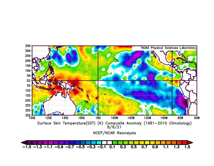
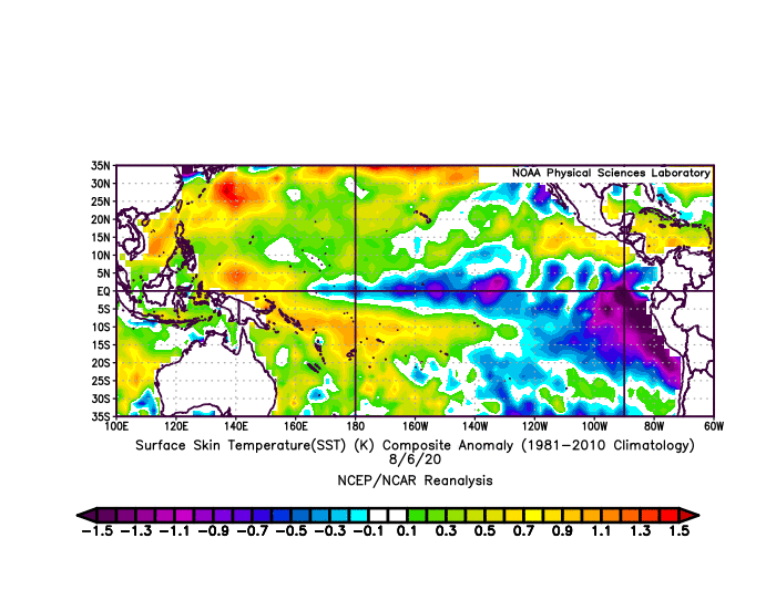
2020 and 2021 both have that. I do not think it is much of a factor.
Image
Image
1 likes   

Shell Mound
Category 5
Category 5
Posts: 2434
Age: 32
Joined: Thu Sep 07, 2017 3:39 pm
Location: St. Petersburg, FL → Scandinavia

Re: 2021 Indicators: SST's / SAL / MSLP / Shear / Steering / Instability / Sat Images

#2355 Postby Shell Mound » Sun Aug 08, 2021 11:54 am

AlphaToOmega wrote:...

This seems to be a bit of a non sequitur. While we will see activity come the peak of the season, I doubt that seasonal ACE will end up higher than ~130. As mentioned previously, the tropical EPAC’s being consistently warmer than the MDR will tend to keep the -VP relatively stationary. This, in turn, will tend to result in a net sink over the Caribbean and western MDR. The MDR, while still warming, will need to warm up even further in order to countervail the tropical EPAC, recent +AMO trends in the far North Atlantic, including the subtropics near the Canadian Maritimes, notwithstanding.
0 likes   
CVW / MiamiensisWx / Shell Mound
The posts in this forum are NOT official forecasts and should not be used as such. They are just the opinion of the poster and may or may not be backed by sound meteorological data. They are NOT endorsed by any professional institution or STORM2K. For official information, please refer to products from the NHC and NWS.

User avatar
Category5Kaiju
Category 5
Category 5
Posts: 4097
Joined: Thu Dec 24, 2020 12:45 pm
Location: Seattle

Re: 2021 Indicators: SST's / SAL / MSLP / Shear / Steering / Instability / Sat Images

#2356 Postby Category5Kaiju » Sun Aug 08, 2021 12:00 pm

Here's what I personally think: I simply just think the EPAC is having a very front-loaded season. With a -ENSO that is likely going to occur, which is usually one of the most reliable and consistent indicators for Atlantic activity, I think while the EPAC activity now may hurt the Atlantic, it's hard to imagine the EPAC constantly churning up systems while squashing the Atlantic in a -PDO, -PMM, -ENSO year during ASO. Sure, the Atlantic may be cooler than last year at this point in time, but we are comparing this year being cooler relative to a record-breaking 30/14/7 year. I don't think that is a very fair comparison to make. I am pretty sure the Atlantic will wake up soon and that we will be tracking storms left and right, but unless some extremely bizarre and elusive factor suddenly comes into play that makes the Atlantic dead despite all of the otherwise favorable factors predicted for at least an 18 NS year (which I would be more than happy to study after this season is over assuming that factor does indeed screw up this season), I think it is safe to say that after August 20, we will be tracking an increasingly active basin.
3 likes   
Unless explicitly stated, all info in my posts is based on my own opinions and observations. Tropical storms and hurricanes can be extremely dangerous. Do not think you can beat Mother Nature. Refer to an accredited weather research agency or meteorologist if you need to make serious decisions regarding an approaching storm.

User avatar
ElectricStorm
Category 5
Category 5
Posts: 5044
Age: 24
Joined: Tue Aug 13, 2019 11:23 pm
Location: Skiatook, OK / Norman, OK

Re: 2021 Indicators: SST's / SAL / MSLP / Shear / Steering / Instability / Sat Images

#2357 Postby ElectricStorm » Sun Aug 08, 2021 12:10 pm

WiscoWx02 wrote:
AlphaToOmega wrote:
Weather Dude wrote:I posted this on Jan. 1 and it looks to be in full effect for some posters on here :lol: Seems like some people were spoiled by the constant storms last year and anything less than that they call for a below average season...

15-16 storms seems like an underestimate, but I do agree that people should not be calling for a below-average season just because of a lull of activity. In my opinion, a hyperactive season still seems likely.


My thoughts exactly! Every year is going to look "unfavorable" after a fiasco like last year. Same after 2017 (new member but have been reading these forums since 2017 incidentally) and I'm sure after 2005. This year has no doubt been a head scratcher in terms of indicators, with very conflicting signals at times. But with the MJO going into Phases 1 and 2 this week, you gotta figure something's going to give soon, maybe not 93L or 94L, but something behind it for sure. After that, buckle up!

Yep. Also people need to realize that early August still usually isn't very favorable in the Atlantic so not seeing much at this point in the year isn't very unusual. Not to mention we have 3 invests out there, 2 of which I think have a good chance to develop.
3 likes   
B.S Meteorology, University of Oklahoma '25

Please refer to the NHC, NWS, or SPC for official information.

User avatar
Category5Kaiju
Category 5
Category 5
Posts: 4097
Joined: Thu Dec 24, 2020 12:45 pm
Location: Seattle

Re: 2021 Indicators: SST's / SAL / MSLP / Shear / Steering / Instability / Sat Images

#2358 Postby Category5Kaiju » Sun Aug 08, 2021 12:20 pm

Fun but important fact: the last season to feature an impactful major hurricane before mid-August (that is, August 15) was 2005. Ever since then, no season has ever managed to feature a major, impactful hurricane, let alone a major hurricane itself, before August 15. The closest seasons that did this were 2007 and 2009 with Dean and Bill respectively in the August 15-20 timeframe. But after August 20 is when the horse gates really open. I guess it's "stormtracker flashbacks" from 2005, but I think sometimes people have too high of expectations for a given season and take the lack of major hurricanes before August 20 to be a sign of a bust. This is clearly not a safe or accurate mindset to have.
6 likes   
Unless explicitly stated, all info in my posts is based on my own opinions and observations. Tropical storms and hurricanes can be extremely dangerous. Do not think you can beat Mother Nature. Refer to an accredited weather research agency or meteorologist if you need to make serious decisions regarding an approaching storm.

AlphaToOmega
Category 5
Category 5
Posts: 1448
Joined: Sat Jun 26, 2021 10:51 am
Location: Somewhere in Massachusetts

Re: 2021 Indicators: SST's / SAL / MSLP / Shear / Steering / Instability / Sat Images

#2359 Postby AlphaToOmega » Sun Aug 08, 2021 12:26 pm

The Atlantic has been so favorable the past few years that even El Niño years such as 2018 and 2019 produced above-average seasons. The general pattern according to the climate models is the most favorable pattern possible for an Atlantic hurricane season: +AMO, +TNA, -ENSO, -PDO, +VP over Africa, and -VP over the Americas and EPac; the only other season in the satellite era with this pattern were 2020 and 2010, both of which were hyperactive. I cannot see how 2021 could be anything but hyperactive. 2010 demonstrates how back-loaded a hurricane season can get: three storms before August 20, sixteen storms after August 20. In fact, 2010 underperformed due to dry air during the peak season. That will most likely not be a problem for 2021, so I think 2021 is likely to outdo 2010. I strongly believe the season will end up being hyperactive, and I cannot see how the season could be below-average or near-average. People expect every season to be either like the 1964 Pacific Typhoon Season or the 1914 Atlantic Hurricane Season.
0 likes   

User avatar
cycloneye
Admin
Admin
Posts: 145327
Age: 68
Joined: Thu Oct 10, 2002 10:54 am
Location: San Juan, Puerto Rico

Re: 2021 Indicators: SST's / SAL / MSLP / Shear / Steering / Instability / Sat Images

#2360 Postby cycloneye » Sun Aug 08, 2021 1:43 pm

1 likes   
Visit the Caribbean-Central America Weather Thread where you can find at first post web cams,radars
and observations from Caribbean basin members Click Here


Return to “Talkin' Tropics”

Who is online

Users browsing this forum: GCANE and 18 guests