ATL: FRED - Models
Moderator: S2k Moderators
-
cycloneye

- Admin

- Posts: 149550
- Age: 69
- Joined: Thu Oct 10, 2002 10:54 am
- Location: San Juan, Puerto Rico
ATL: FRED - Models
Only model runs here.
0 likes
Visit the Caribbean-Central America Weather Thread where you can find at first post web cams,radars
and observations from Caribbean basin members Click Here
and observations from Caribbean basin members Click Here


-
SFLcane

- S2K Supporter

- Posts: 10281
- Age: 48
- Joined: Sat Jun 05, 2010 1:44 pm
- Location: Lake Worth Florida
Re: ATL: 94L - Models
1-2 punch potentially for South Florida whether it’s a tc or a batch of showers who knows lol.
0 likes


Re: ATL: 94L - Models
0Z UKMET does develop this into a TD in the E Caribbean Tuesday but it never gets stronger. The UKMET fwiw can be conservatively weak. So, we’ll see. This is just guidance.
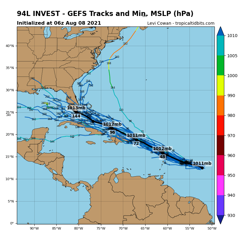
NEW TROPICAL CYCLONE FORECAST TO DEVELOP AFTER 60 HOURS
FORECAST POSITION AT T+ 60 : 17.3N 63.3W
LEAD CENTRAL MAXIMUM WIND
VERIFYING TIME TIME POSITION PRESSURE (MB) SPEED (KNOTS)
-------------- ---- -------- ------------- -------------
1200UTC 10.08.2021 60 17.3N 63.3W 1013 28
0000UTC 11.08.2021 72 18.7N 66.3W 1012 27
1200UTC 11.08.2021 84 19.6N 69.0W 1011 28
0000UTC 12.08.2021 96 20.7N 71.5W 1011 29
1200UTC 12.08.2021 108 21.7N 74.0W 1012 26
0000UTC 13.08.2021 120 22.4N 76.2W 1012 25
1200UTC 13.08.2021 132 23.2N 78.0W 1013 22
0000UTC 14.08.2021 144 23.9N 80.0W 1013 26
4 likes
Personal Forecast Disclaimer:
The posts in this forum are NOT official forecasts and should not be used as such. They are just the opinion of the poster and may or may not be backed by sound meteorological data. They are NOT endorsed by any professional institution or storm2k.org. For official information, please refer to the NHC and NWS products.
The posts in this forum are NOT official forecasts and should not be used as such. They are just the opinion of the poster and may or may not be backed by sound meteorological data. They are NOT endorsed by any professional institution or storm2k.org. For official information, please refer to the NHC and NWS products.
-
Spacecoast

- Category 2

- Posts: 773
- Joined: Thu Aug 31, 2017 2:03 pm
Re: ATL: 94L - Models
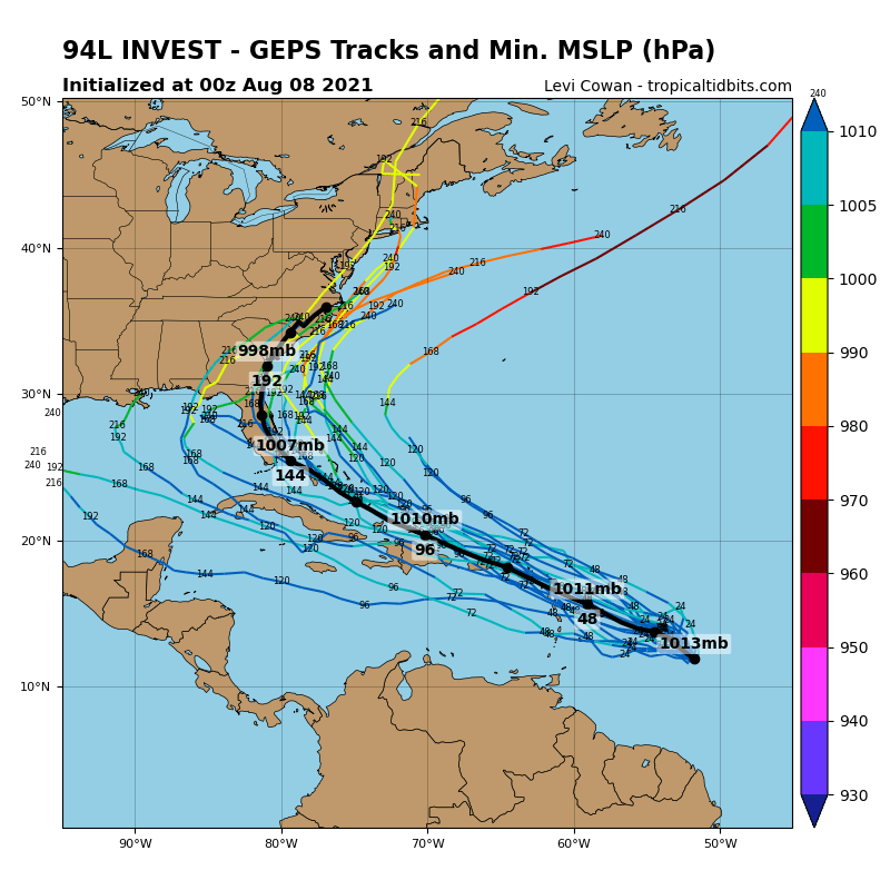
0z ECMF Ensembles..
Thin line is ensemble mean,
Thick line (ECMF) is operational

Thin line is ensemble mean,
Thick line (ECMF) is operational
1 likes
-
AlphaToOmega
- Category 5

- Posts: 1448
- Joined: Sat Jun 26, 2021 10:51 am
- Location: Somewhere in Massachusetts
-
Blown Away

- S2K Supporter
- Posts: 10253
- Joined: Wed May 26, 2004 6:17 am
Re: ATL: 94L - Models
12z GFS = Moderate rain event at best through 6 days...
0 likes
Hurricane Eye Experience: David 79, Irene 99, Frances 04, Jeanne 04, Wilma 05… Hurricane Brush Experience: Andrew 92, Erin 95, Floyd 99, Matthew 16, Irma 17, Ian 22, Nicole 22…
-
SFLcane
- S2K Supporter
- Posts: 10281
- Age: 48
- Joined: Sat Jun 05, 2010 1:44 pm
- Location: Lake Worth Florida
Re: ATL: 94L - Models
Blown Away wrote:12z GFS = Moderate rain event at best through 6 days...
1-2 punch of some rain.
1 likes
Re: ATL: 94L - Models
The 12z GFS is trending towards the Euro with the ULL pushing towards the GOM by the time 94L gets close to SE FL, something to keep an eye on.

1 likes
Re: ATL: 94L - Models
So far through 18 hrs 12z HWRF shows the dry air to the NW of 94L keep pushing west out of the way of 94L.

0 likes
-
Shell Mound
- Category 5
- Posts: 2432
- Age: 33
- Joined: Thu Sep 07, 2017 3:39 pm
- Location: St. Petersburg, FL → Scandinavia
Re: ATL: 94L - Models
NDG wrote:So far through 18 hrs 12z HWRF shows the dry air to the NW of 94L keep pushing west out of the way of 94L.
https://i.imgur.com/2ZDFasQ.png

Given the current level of disorganisation, this seems highly unlikely. 94L’s circulation is quite tilted with height, so the HWRF’s solution seems unrealistic.
0 likes
CVW / MiamiensisWx / Shell Mound
The posts in this forum are NOT official forecasts and should not be used as such. They are just the opinion of the poster and may or may not be backed by sound meteorological data. They are NOT endorsed by any professional institution or STORM2K. For official information, please refer to products from the NHC and NWS.
Re: ATL: 94L - Models
Shell Mound wrote:NDG wrote:So far through 18 hrs 12z HWRF shows the dry air to the NW of 94L keep pushing west out of the way of 94L.
https://i.imgur.com/2ZDFasQ.png
https://i.ibb.co/C694jJM/Hurricane-1.png
Given the current level of disorganisation, this seems highly unlikely. 94L’s circulation is quite tilted with height, so the HWRF’s solution seems unrealistic.
But if you look at the HWRF it clearly shows the mid level circulation to the south but becoming stacked by tomorrow night thus intensification starting by then.
1 likes
-
Shell Mound
- Category 5
- Posts: 2432
- Age: 33
- Joined: Thu Sep 07, 2017 3:39 pm
- Location: St. Petersburg, FL → Scandinavia
Re: ATL: 94L - Models
NDG wrote:Shell Mound wrote:NDG wrote:So far through 18 hrs 12z HWRF shows the dry air to the NW of 94L keep pushing west out of the way of 94L.
https://i.imgur.com/2ZDFasQ.png
https://i.ibb.co/C694jJM/Hurricane-1.png
Given the current level of disorganisation, this seems highly unlikely. 94L’s circulation is quite tilted with height, so the HWRF’s solution seems unrealistic.
But if you look at the HWRF it clearly shows the mid level circulation to the south but becoming stacked by tomorrow night thus intensification starting by then.
Even so, the HWRF is too slow and deep within the next few days. Currently 94L is moving faster than the HWRF indicates. Yet HWRF shows RI just N of Martinique.
0 likes
CVW / MiamiensisWx / Shell Mound
The posts in this forum are NOT official forecasts and should not be used as such. They are just the opinion of the poster and may or may not be backed by sound meteorological data. They are NOT endorsed by any professional institution or STORM2K. For official information, please refer to products from the NHC and NWS.

Re: ATL: 94L - Models
Shell Mound wrote:NDG wrote:So far through 18 hrs 12z HWRF shows the dry air to the NW of 94L keep pushing west out of the way of 94L.
https://i.imgur.com/2ZDFasQ.png
https://i.ibb.co/C694jJM/Hurricane-1.png
Given the current level of disorganisation, this seems highly unlikely. 94L’s circulation is quite tilted with height, so the HWRF’s solution seems unrealistic.
To be fair, the HWRF doesn’t show a closed circulation until 30hr and the MLC/LLC aren’t stacked until it’s already passing through the islands at 45hr. It’s not like it’s showing a stacked system within 24-30 hours.
0 likes
Irene '11 Sandy '12 Hermine '16 5/15/2018 Derecho Fay '20 Isaias '20 Elsa '21 Henri '21 Ida '21
I am only a meteorology enthusiast who knows a decent amount about tropical cyclones. Look to the professional mets, the NHC, or your local weather office for the best information.
I am only a meteorology enthusiast who knows a decent amount about tropical cyclones. Look to the professional mets, the NHC, or your local weather office for the best information.
Re: ATL: 94L - Models
Shell Mound wrote:NDG wrote:Shell Mound wrote:https://i.ibb.co/C694jJM/Hurricane-1.png
Given the current level of disorganisation, this seems highly unlikely. 94L’s circulation is quite tilted with height, so the HWRF’s solution seems unrealistic.
But if you look at the HWRF it clearly shows the mid level circulation to the south but becoming stacked by tomorrow night thus intensification starting by then.
Even so, the HWRF is too slow and deep within the next few days. Currently 94L is moving faster than the HWRF indicates. Yet HWRF shows RI just N of Martinique.
Yes, but not by that much, I have the main vorticity near 13N & 54.2W, that' pretty close to what the HWRF shows the elongated vorticity to be at 18z.
2 likes
-
Blown Away
- S2K Supporter
- Posts: 10253
- Joined: Wed May 26, 2004 6:17 am
Re: ATL: 94L - Models
Shell Mound wrote:NDG wrote:So far through 18 hrs 12z HWRF shows the dry air to the NW of 94L keep pushing west out of the way of 94L.
https://i.imgur.com/2ZDFasQ.png
https://i.ibb.co/C694jJM/Hurricane-1.png
Given the current level of disorganisation, this seems highly unlikely. 94L’s circulation is quite tilted with height, so the HWRF’s solution seems unrealistic.
Yes HWRF tends to overplay intensity, but seems to be remarkably good with the IR Brightness predictions...
1 likes
Hurricane Eye Experience: David 79, Irene 99, Frances 04, Jeanne 04, Wilma 05… Hurricane Brush Experience: Andrew 92, Erin 95, Floyd 99, Matthew 16, Irma 17, Ian 22, Nicole 22…
Re: ATL: 94L - Models
HWRF @72hr has a minimal hurricane heading right for The Shredder. 94L loses some organization after passing between some of the smaller islands, but recovers enough to get this strong.
0 likes
Irene '11 Sandy '12 Hermine '16 5/15/2018 Derecho Fay '20 Isaias '20 Elsa '21 Henri '21 Ida '21
I am only a meteorology enthusiast who knows a decent amount about tropical cyclones. Look to the professional mets, the NHC, or your local weather office for the best information.
I am only a meteorology enthusiast who knows a decent amount about tropical cyclones. Look to the professional mets, the NHC, or your local weather office for the best information.
Who is online
Users browsing this forum: No registered users and 14 guests