2021 Indicators: SST's / SAL / MSLP / Shear / Steering / Instability / Sat Images

This is the general tropical discussion area. Anyone can take their shot at predicting a storms path.

Moderator: S2k Moderators

Forum rules

The posts in this forum are NOT official forecasts and should not be used as such. They are just the opinion of the poster and may or may not be backed by sound meteorological data. They are NOT endorsed by any professional institution or STORM2K. For official information, please refer to products from the National Hurricane Center and National Weather Service.

Help Support Storm2K
Message
Author
User avatar
Teban54
Category 5
Category 5
Posts: 3206
Joined: Sat May 19, 2018 1:19 pm

Re: 2021 Indicators: SST's / SAL / MSLP / Shear / Steering / Instability / Sat Images

#2361 Postby Teban54 » Sun Aug 08, 2021 1:43 pm

Category5Kaiju wrote:Fun but important fact: the last season to feature an impactful major hurricane before mid-August (that is, August 15) was 2005. Ever since then, no season has ever managed to feature a major, impactful hurricane, let alone a major hurricane itself, before August 15. The closest seasons that did this were 2007 and 2009 with Dean and Bill respectively in the August 15-20 timeframe. But after August 20 is when the horse gates really open. I guess it's "stormtracker flashbacks" from 2005, but I think sometimes people have too high of expectations for a given season and take the lack of major hurricanes before August 20 to be a sign of a bust. This is clearly not a safe or accurate mindset to have.


Didn't someone share a tweet earlier that said early August activity has negative correlation with peak season activity according to historical data? The reason mostly being an active early August suggests a favorable MJO at this time, so by peak season a few weeks later the MJO has moved out.
0 likes   

tolakram
Admin
Admin
Posts: 20009
Age: 62
Joined: Sun Aug 27, 2006 8:23 pm
Location: Florence, KY (name is Mark)

Re: 2021 Indicators: SST's / SAL / MSLP / Shear / Steering / Instability / Sat Images

#2362 Postby tolakram » Sun Aug 08, 2021 1:58 pm

There's nothing wrong with predicting a slow season. Not that anyone has done anything wrong here, but give everyone space to say what they think. We're going to have another few intense weeks of cancel angst, so let's remember to be friendly.

We don't allow trolling, and usually the difference is pretty clear. Someone using reason and evidence to support their opinion might be horribly biased and not realize it, but they aren't trolling any more than the person convinced this is going to be a hyper active year because of various reasons. :lol:

I'm not convinced either way.
11 likes   
M a r k
- - - - -
Join us in chat: Storm2K Chatroom Invite. Android and IOS apps also available.

The posts in this forum are NOT official forecasts and should not be used as such. Posts are NOT endorsed by any professional institution or STORM2K.org. For official information and forecasts, please refer to NHC and NWS products.

User avatar
AnnularCane
S2K Supporter
S2K Supporter
Posts: 2862
Joined: Thu Jun 08, 2006 9:18 am
Location: Wytheville, VA

Re: 2021 Indicators: SST's / SAL / MSLP / Shear / Steering / Instability / Sat Images

#2363 Postby AnnularCane » Sun Aug 08, 2021 2:01 pm


New thread coming soon? :wink:
1 likes   
"But it never rained rain. It never snowed snow. And it never blew just wind. It rained things like soup and juice. It snowed mashed potatoes and green peas. And sometimes the wind blew in storms of hamburgers." -- Judi Barrett, Cloudy with a Chance of Meatballs

User avatar
Category5Kaiju
Category 5
Category 5
Posts: 4097
Joined: Thu Dec 24, 2020 12:45 pm
Location: Seattle

Re: 2021 Indicators: SST's / SAL / MSLP / Shear / Steering / Instability / Sat Images

#2364 Postby Category5Kaiju » Sun Aug 08, 2021 2:09 pm

Teban54 wrote:
Category5Kaiju wrote:Fun but important fact: the last season to feature an impactful major hurricane before mid-August (that is, August 15) was 2005. Ever since then, no season has ever managed to feature a major, impactful hurricane, let alone a major hurricane itself, before August 15. The closest seasons that did this were 2007 and 2009 with Dean and Bill respectively in the August 15-20 timeframe. But after August 20 is when the horse gates really open. I guess it's "stormtracker flashbacks" from 2005, but I think sometimes people have too high of expectations for a given season and take the lack of major hurricanes before August 20 to be a sign of a bust. This is clearly not a safe or accurate mindset to have.


Didn't someone share a tweet earlier that said early August activity has negative correlation with peak season activity according to historical data? The reason mostly being an active early August suggests a favorable MJO at this time, so by peak season a few weeks later the MJO has moved out.


Might have been Yaakov Cantor, but it’s because typically the MJO is a 30-40 day cycle between active and suppressive, so an active early August would mean a suppressive September and a less active September than if the MJO’s favorable phase were to occur then instead
1 likes   
Unless explicitly stated, all info in my posts is based on my own opinions and observations. Tropical storms and hurricanes can be extremely dangerous. Do not think you can beat Mother Nature. Refer to an accredited weather research agency or meteorologist if you need to make serious decisions regarding an approaching storm.

User avatar
aspen
Category 5
Category 5
Posts: 8818
Joined: Sat Oct 12, 2019 7:10 pm
Location: Connecticut, USA

Re: 2021 Indicators: SST's / SAL / MSLP / Shear / Steering / Instability / Sat Images

#2365 Postby aspen » Sun Aug 08, 2021 2:13 pm


That might be the wave responsible for the Caribbean Cruiser appearing on some of the GFS/Euro OP/ensembles runs over the last few days. The GFS has the precursor wave make splashdown as early as tomorrow, and this is the only wave that could be.
0 likes   
Irene '11 Sandy '12 Hermine '16 5/15/2018 Derecho Fay '20 Isaias '20 Elsa '21 Henri '21 Ida '21

I am only a meteorology enthusiast who knows a decent amount about tropical cyclones. Look to the professional mets, the NHC, or your local weather office for the best information.

psyclone
S2K Supporter
S2K Supporter
Posts: 4762
Joined: Wed Aug 24, 2005 9:04 pm
Location: palm harbor fl

Re: 2021 Indicators: SST's / SAL / MSLP / Shear / Steering / Instability / Sat Images

#2366 Postby psyclone » Sun Aug 08, 2021 2:26 pm

The good news here is we're going to get a verdict either way very soon.
May = No way
June = Too soon
July = Oh so dry
August = start lookin'
September = we're cookin'...

For weather fanatics it would be nicer if our storms were more evenly distributed but that's not the way it works. I'll be shocked if we don't have at least 3 simultaneous systems at some point this season, probably in September. In the meantime as usual it's hurry up and wait.
8 likes   

User avatar
aspen
Category 5
Category 5
Posts: 8818
Joined: Sat Oct 12, 2019 7:10 pm
Location: Connecticut, USA

Re: 2021 Indicators: SST's / SAL / MSLP / Shear / Steering / Instability / Sat Images

#2367 Postby aspen » Sun Aug 08, 2021 6:18 pm

I think we should have a thread for the wave about to move off the coast of Africa. It has decent ensemble and operational run support from the GFS, and all of these failed invests might have made the environment ahead of it more favorable.
0 likes   
Irene '11 Sandy '12 Hermine '16 5/15/2018 Derecho Fay '20 Isaias '20 Elsa '21 Henri '21 Ida '21

I am only a meteorology enthusiast who knows a decent amount about tropical cyclones. Look to the professional mets, the NHC, or your local weather office for the best information.

User avatar
toad strangler
S2K Supporter
S2K Supporter
Posts: 4543
Joined: Sun Jul 28, 2013 3:09 pm
Location: Earth
Contact:

Re: 2021 Indicators: SST's / SAL / MSLP / Shear / Steering / Instability / Sat Images

#2368 Postby toad strangler » Sun Aug 08, 2021 6:19 pm

aspen wrote:I think we should have a thread for the wave about to move off the coast of Africa. It has decent ensemble and operational run support from the GFS, and all of these failed invests might have made the environment ahead of it more favorable.


You might be premature in declaring “all of these failed invests”
5 likes   

User avatar
aspen
Category 5
Category 5
Posts: 8818
Joined: Sat Oct 12, 2019 7:10 pm
Location: Connecticut, USA

Re: 2021 Indicators: SST's / SAL / MSLP / Shear / Steering / Instability / Sat Images

#2369 Postby aspen » Sun Aug 08, 2021 6:26 pm

toad strangler wrote:
aspen wrote:I think we should have a thread for the wave about to move off the coast of Africa. It has decent ensemble and operational run support from the GFS, and all of these failed invests might have made the environment ahead of it more favorable.


You might be premature in declaring “all of these failed invests”

Okay, some failed invests and some waves that may or may not still develop. Even if 94L becomes Fred, it might end up as a sacrificial storm to clear out some dry air near the Lesser Antilles.
1 likes   
Irene '11 Sandy '12 Hermine '16 5/15/2018 Derecho Fay '20 Isaias '20 Elsa '21 Henri '21 Ida '21

I am only a meteorology enthusiast who knows a decent amount about tropical cyclones. Look to the professional mets, the NHC, or your local weather office for the best information.

User avatar
Category5Kaiju
Category 5
Category 5
Posts: 4097
Joined: Thu Dec 24, 2020 12:45 pm
Location: Seattle

Re: 2021 Indicators: SST's / SAL / MSLP / Shear / Steering / Instability / Sat Images

#2370 Postby Category5Kaiju » Sun Aug 08, 2021 6:53 pm

aspen wrote:
toad strangler wrote:
aspen wrote:I think we should have a thread for the wave about to move off the coast of Africa. It has decent ensemble and operational run support from the GFS, and all of these failed invests might have made the environment ahead of it more favorable.


You might be premature in declaring “all of these failed invests”

Okay, some failed invests and some waves that may or may not still develop. Even if 94L becomes Fred, it might end up as a sacrificial storm to clear out some dry air near the Lesser Antilles.


I guess we'll see, but as of now 94L recently had a big blow up, and 93L is about to ride under a SAL plume's trough; I still wouldn't expect anything major out of any system, but I agree that these are likely the precursors to whatever the models have been hinting at later this week. There's still imho a chance we see Fred soon. Now I have zero idea which system will be Fred, although if I had to guess 94L is the most likely candidate.
0 likes   
Unless explicitly stated, all info in my posts is based on my own opinions and observations. Tropical storms and hurricanes can be extremely dangerous. Do not think you can beat Mother Nature. Refer to an accredited weather research agency or meteorologist if you need to make serious decisions regarding an approaching storm.

User avatar
toad strangler
S2K Supporter
S2K Supporter
Posts: 4543
Joined: Sun Jul 28, 2013 3:09 pm
Location: Earth
Contact:

Re: 2021 Indicators: SST's / SAL / MSLP / Shear / Steering / Instability / Sat Images

#2371 Postby toad strangler » Sun Aug 08, 2021 6:56 pm

Category5Kaiju wrote:
aspen wrote:
toad strangler wrote:
You might be premature in declaring “all of these failed invests”

Okay, some failed invests and some waves that may or may not still develop. Even if 94L becomes Fred, it might end up as a sacrificial storm to clear out some dry air near the Lesser Antilles.


I guess we'll see, but as of now 94L recently had a big blow up, and 93L is about to ride under a SAL plume's trough; I still wouldn't expect anything major out of any system, but I agree that these are likely the precursors to whatever the models have been hinting at later this week. There's still imho a chance we see Fred soon. Now I have zero idea which system will be Fred, although if I had to guess 94L is the most likely candidate.


No guessing needed. Levi Cown flat out said an hour or so ago that 94L is the strongest candidate of these Invests
1 likes   

User avatar
Category5Kaiju
Category 5
Category 5
Posts: 4097
Joined: Thu Dec 24, 2020 12:45 pm
Location: Seattle

Re: 2021 Indicators: SST's / SAL / MSLP / Shear / Steering / Instability / Sat Images

#2372 Postby Category5Kaiju » Sun Aug 08, 2021 7:00 pm

toad strangler wrote:
Category5Kaiju wrote:
aspen wrote:Okay, some failed invests and some waves that may or may not still develop. Even if 94L becomes Fred, it might end up as a sacrificial storm to clear out some dry air near the Lesser Antilles.


I guess we'll see, but as of now 94L recently had a big blow up, and 93L is about to ride under a SAL plume's trough; I still wouldn't expect anything major out of any system, but I agree that these are likely the precursors to whatever the models have been hinting at later this week. There's still imho a chance we see Fred soon. Now I have zero idea which system will be Fred, although if I had to guess 94L is the most likely candidate.


No guessing needed. Levi Cown flat out said an hour or so ago that 94L is the strongest candidate of these Invests


Oh that's coming from Levi Cowan? Then I guess 94L it is 8-)
2 likes   
Unless explicitly stated, all info in my posts is based on my own opinions and observations. Tropical storms and hurricanes can be extremely dangerous. Do not think you can beat Mother Nature. Refer to an accredited weather research agency or meteorologist if you need to make serious decisions regarding an approaching storm.

tolakram
Admin
Admin
Posts: 20009
Age: 62
Joined: Sun Aug 27, 2006 8:23 pm
Location: Florence, KY (name is Mark)

Re: 2021 Indicators: SST's / SAL / MSLP / Shear / Steering / Instability / Sat Images

#2373 Postby tolakram » Sun Aug 08, 2021 7:52 pm

I'll do what I did starting in 2017 and try and document the date and a brief synopsis of what is going on.

It's August 8th. 3 invests exist with 94L having what appears to be the best chance.

I grabbed a WV loop from 2017, that's a re-developing Harvey entering the Gulf. You can clearly see the TUTT here, the one Irma didn't have a problem with. You can also see all that horribly dry air in the Atlantic. This loop is 7 days before Irma formed.

Image

Here's today's WV loop. I can't find the same scale, if someone knows where to get the scale used in 2017 please let me know.
Image
10 likes   
M a r k
- - - - -
Join us in chat: Storm2K Chatroom Invite. Android and IOS apps also available.

The posts in this forum are NOT official forecasts and should not be used as such. Posts are NOT endorsed by any professional institution or STORM2K.org. For official information and forecasts, please refer to NHC and NWS products.

User avatar
AnnularCane
S2K Supporter
S2K Supporter
Posts: 2862
Joined: Thu Jun 08, 2006 9:18 am
Location: Wytheville, VA

Re: 2021 Indicators: SST's / SAL / MSLP / Shear / Steering / Instability / Sat Images

#2374 Postby AnnularCane » Sun Aug 08, 2021 8:05 pm

tolakram wrote:I'll do what I did starting in 2017 and try and document the date and a brief synopsis of what is going on.

It's August 8th. 3 invests exist with 94L having what appears to be the best chance.

I grabbed a WV loop from 2017, that's a re-developing Harvey entering the Gulf. You can clearly see the TUTT here, the one Irma didn't have a problem with. You can also see all that horribly dry air in the Atlantic. THis loop is 13 days before Irma formed.

https://i.imgur.com/W44nMso.gif


Irma formed on the 30th, so actually seven days.
0 likes   
"But it never rained rain. It never snowed snow. And it never blew just wind. It rained things like soup and juice. It snowed mashed potatoes and green peas. And sometimes the wind blew in storms of hamburgers." -- Judi Barrett, Cloudy with a Chance of Meatballs

tolakram
Admin
Admin
Posts: 20009
Age: 62
Joined: Sun Aug 27, 2006 8:23 pm
Location: Florence, KY (name is Mark)

Re: 2021 Indicators: SST's / SAL / MSLP / Shear / Steering / Instability / Sat Images

#2375 Postby tolakram » Sun Aug 08, 2021 8:34 pm

AnnularCane wrote:
tolakram wrote:I'll do what I did starting in 2017 and try and document the date and a brief synopsis of what is going on.

It's August 8th. 3 invests exist with 94L having what appears to be the best chance.

I grabbed a WV loop from 2017, that's a re-developing Harvey entering the Gulf. You can clearly see the TUTT here, the one Irma didn't have a problem with. You can also see all that horribly dry air in the Atlantic. THis loop is 13 days before Irma formed.

https://i.imgur.com/W44nMso.gif


Irma formed on the 30th, so actually seven days.


Right, I read that date wrong. Corrected.
0 likes   
M a r k
- - - - -
Join us in chat: Storm2K Chatroom Invite. Android and IOS apps also available.

The posts in this forum are NOT official forecasts and should not be used as such. Posts are NOT endorsed by any professional institution or STORM2K.org. For official information and forecasts, please refer to NHC and NWS products.

User avatar
WiscoWx02
Category 1
Category 1
Posts: 391
Joined: Sat Jul 31, 2021 8:09 pm

Re: 2021 Indicators: SST's / SAL / MSLP / Shear / Steering / Instability / Sat Images

#2376 Postby WiscoWx02 » Sun Aug 08, 2021 8:54 pm

Image

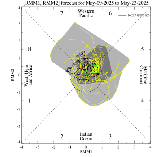
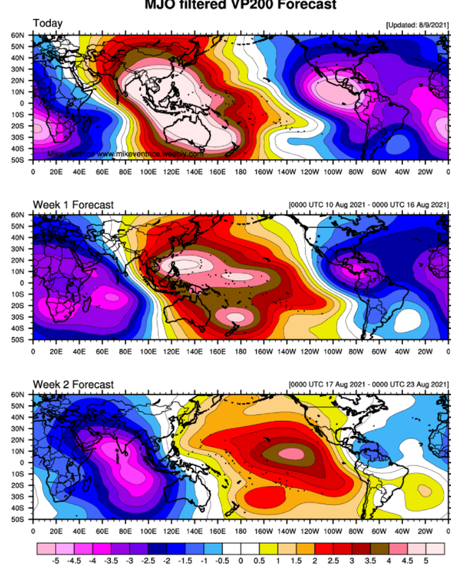
MJO about to step up its game while it dances between phases 1 and 2. One heck of an amplification :eek:
We'll have to see if this actually materializes and if the eastern Pacific shuts down enough to allow the Atlantic to reach its full potential while it comes through. Figure if Elsa was able to form in early July with the strength of the MJO then, something is definitely on the way now.
3 likes   

User avatar
Stormybajan
Category 1
Category 1
Posts: 448
Joined: Thu May 20, 2021 3:21 pm
Location: Windward Islands

Re: 2021 Indicators: SST's / SAL / MSLP / Shear / Steering / Instability / Sat Images

#2377 Postby Stormybajan » Sun Aug 08, 2021 9:15 pm

WiscoWx02 wrote:https://www.cpc.ncep.noaa.gov/products/precip/CWlink/MJO/ensplume_full.gif

MJO about to step up its game while it dances between phases 1 and 2. One heck of an amplification :eek:
We'll have to see if this actually materializes and if the eastern Pacific shuts down enough to allow the Atlantic to reach its full potential while it comes through. Figure if Elsa was able to form in early July with the strength of the MJO then, something is definitely on the way now.

Image
Really is quite the signal, still, I give the Atlantic 7-12 days to wake up (August 15th-20th)
1 likes   
Sad West Indies and Manchester United fan ⚽️

User avatar
Woofde
Category 1
Category 1
Posts: 480
Joined: Tue Jul 06, 2021 11:33 am

Re: RE: Re: 2021 Indicators: SST's / SAL / MSLP / Shear / Steering / Instability / Sat Images

#2378 Postby Woofde » Sun Aug 08, 2021 9:35 pm

Stormybajan wrote:
WiscoWx02 wrote:https://www.cpc.ncep.noaa.gov/products/precip/CWlink/MJO/ensplume_full.gif

MJO about to step up its game while it dances between phases 1 and 2. One heck of an amplification :eek:
We'll have to see if this actually materializes and if the eastern Pacific shuts down enough to allow the Atlantic to reach its full potential while it comes through. Figure if Elsa was able to form in early July with the strength of the MJO then, something is definitely on the way now.

Image
Really is quite the signal, still, I give the Atlantic 7-12 days to wake up (August 15th-20th)
That's the usual time it wakes up too. With a positive MJO it could be quite the awakening.

Sent from my SM-G988U1 using Tapatalk
2 likes   

Deshaunrob17
Tropical Storm
Tropical Storm
Posts: 207
Joined: Tue Aug 18, 2020 7:49 am

Re: 2021 Indicators: SST's / SAL / MSLP / Shear / Steering / Instability / Sat Images

#2379 Postby Deshaunrob17 » Sun Aug 08, 2021 9:43 pm

tolakram wrote:I'll do what I did starting in 2017 and try and document the date and a brief synopsis of what is going on.

It's August 8th. 3 invests exist with 94L having what appears to be the best chance.

I grabbed a WV loop from 2017, that's a re-developing Harvey entering the Gulf. You can clearly see the TUTT here, the one Irma didn't have a problem with. You can also see all that horribly dry air in the Atlantic. This loop is 7 days before Irma formed.

https://i.imgur.com/W44nMso.gif

Here's today's WV loop. I can't find the same scale, if someone knows where to get the scale used in 2017 please let me know.
https://i.imgur.com/pmFDz83.gif


Harvey always amazes me.. Entered the Gulf as a disorganized, elongated mess. Made landfall as 130 mph Cat 4. How the hell did that happen
5 likes   

User avatar
Category5Kaiju
Category 5
Category 5
Posts: 4097
Joined: Thu Dec 24, 2020 12:45 pm
Location: Seattle

Re: 2021 Indicators: SST's / SAL / MSLP / Shear / Steering / Instability / Sat Images

#2380 Postby Category5Kaiju » Sun Aug 08, 2021 9:59 pm

Deshaunrob17 wrote:
tolakram wrote:I'll do what I did starting in 2017 and try and document the date and a brief synopsis of what is going on.

It's August 8th. 3 invests exist with 94L having what appears to be the best chance.

I grabbed a WV loop from 2017, that's a re-developing Harvey entering the Gulf. You can clearly see the TUTT here, the one Irma didn't have a problem with. You can also see all that horribly dry air in the Atlantic. This loop is 7 days before Irma formed.

https://i.imgur.com/W44nMso.gif

Here's today's WV loop. I can't find the same scale, if someone knows where to get the scale used in 2017 please let me know.
https://i.imgur.com/pmFDz83.gif


Harvey always amazes me.. Entered the Gulf as a disorganized, elongated mess. Made landfall as 130 mph Cat 4. How the hell did that happen


It just so happened that the Gulf was very favorable shear-wise and humidity-wise to support a powerful cyclone. That's why in the tropics, you never write off a struggling TS until there's absolute proof and evidence that it is indeed screwed, especially starting in late August. In most cases it probably won't amount to much, but then there are those isolated times when you could get super bad luck and end up with a storm like Harvey, Andrew, or Laura.
4 likes   
Unless explicitly stated, all info in my posts is based on my own opinions and observations. Tropical storms and hurricanes can be extremely dangerous. Do not think you can beat Mother Nature. Refer to an accredited weather research agency or meteorologist if you need to make serious decisions regarding an approaching storm.


Return to “Talkin' Tropics”

Who is online

Users browsing this forum: duilaslol, NotSparta and 36 guests