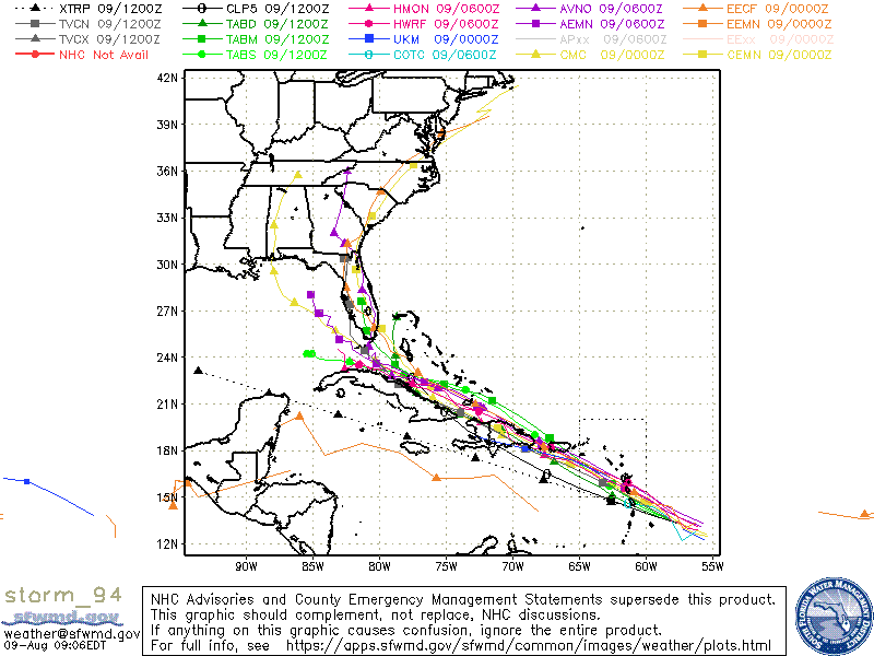
The 06Z GFS is much stronger through 24h. For the first time the GFS is showing a depression or stronger impacting the Lesser Antilles.
It remains insistent on a track toward St. Croix and Puerto Rico through 48h. Afterward strong VWS still looks to be an issue for 94L.
On another note, most of the 00Z EPS members that do develop 94L now show the system tracking just east of FL and toward GA/SC.
ATL: FRED - Models
Moderator: S2k Moderators
-
Shell Mound
- Category 5

- Posts: 2432
- Age: 33
- Joined: Thu Sep 07, 2017 3:39 pm
- Location: St. Petersburg, FL → Scandinavia
Re: ATL: 94L - Models
0 likes
CVW / MiamiensisWx / Shell Mound
The posts in this forum are NOT official forecasts and should not be used as such. They are just the opinion of the poster and may or may not be backed by sound meteorological data. They are NOT endorsed by any professional institution or STORM2K. For official information, please refer to products from the NHC and NWS.
-
Blown Away

- S2K Supporter

- Posts: 10253
- Joined: Wed May 26, 2004 6:17 am
Re: ATL: 94L - Models
Shell Mound wrote:The 06Z GFS is much stronger through 24h. For the first time the GFS is showing a depression or stronger impacting the Lesser Antilles.
It remains insistent on a track toward St. Croix and Puerto Rico through 48h. Afterward strong VWS still looks to be an issue for 94L.
On another note, most of the 00Z EPS members that do develop 94L now show the system tracking just east of FL and toward GA/SC.

00z Euro ensembles... The stronger system seems to gain latitude and move over NE Caribbean/PR and miss Hispaniola... The ones going W in the Caribbean are from 93L...
0 likes
Hurricane Eye Experience: David 79, Irene 99, Frances 04, Jeanne 04, Wilma 05… Hurricane Brush Experience: Andrew 92, Erin 95, Floyd 99, Matthew 16, Irma 17, Ian 22, Nicole 22…
-
jlauderdal
- S2K Supporter
- Posts: 7240
- Joined: Wed May 19, 2004 5:46 am
- Location: NE Fort Lauderdale
- Contact:
Re: ATL: 94L - Models
good test for the euro after last months major fail with bringing the energy to the east of florida..as always goes with nhc for track guidance and trends, they don't miss by much out to 5 daysBlown Away wrote:Shell Mound wrote:The 06Z GFS is much stronger through 24h. For the first time the GFS is showing a depression or stronger impacting the Lesser Antilles.
It remains insistent on a track toward St. Croix and Puerto Rico through 48h. Afterward strong VWS still looks to be an issue for 94L.
On another note, most of the 00Z EPS members that do develop 94L now show the system tracking just east of FL and toward GA/SC.
https://i.imgur.com/HwQ6lk6.jpg
00z Euro ensembles... The stronger system seems to gain latitude and move over NE Caribbean/PR and miss Hispaniola... The ones going W in the Caribbean are from 93L...
1 likes

Re: ATL: 94L - Models
Shell Mound wrote:The 06Z GFS is much stronger through 24h. For the first time the GFS is showing a depression or stronger impacting the Lesser Antilles.
It remains insistent on a track toward St. Croix and Puerto Rico through 48h. Afterward strong VWS still looks to be an issue for 94L.
On another note, most of the 00Z EPS members that do develop 94L now show the system tracking just east of FL and toward GA/SC.
Don't forget how far to the right biased the Euro was with Elsa near FL.
0 likes
Re: ATL: 94L - Models
So far the Consensus has been right biased, yet another Elsa scenario might be playing out. Don't bet yet on a track directly over the Shredder.

2 likes

Re: ATL: 94L - Models
0 likes
-
Shell Mound
- Category 5
- Posts: 2432
- Age: 33
- Joined: Thu Sep 07, 2017 3:39 pm
- Location: St. Petersburg, FL → Scandinavia
Re: ATL: 94L - Models
NDG wrote:Shell Mound wrote:The 06Z GFS is much stronger through 24h. For the first time the GFS is showing a depression or stronger impacting the Lesser Antilles.
It remains insistent on a track toward St. Croix and Puerto Rico through 48h. Afterward strong VWS still looks to be an issue for 94L.
On another note, most of the 00Z EPS members that do develop 94L now show the system tracking just east of FL and toward GA/SC.
Don't forget how far to the right biased the Euro was with Elsa near FL.
Doesn’t the ECMWF still show considerable VWS due to the ULL near or over Florida?
0 likes
CVW / MiamiensisWx / Shell Mound
The posts in this forum are NOT official forecasts and should not be used as such. They are just the opinion of the poster and may or may not be backed by sound meteorological data. They are NOT endorsed by any professional institution or STORM2K. For official information, please refer to products from the NHC and NWS.
-
tolakram
- Admin

- Posts: 20186
- Age: 62
- Joined: Sun Aug 27, 2006 8:23 pm
- Location: Florence, KY (name is Mark)
Re: ATL: 94L - Models
Southeast Florida is very difficult to hit (I know people think otherwise, but it's protected by the Islands). A track just north of the Hispaniola and a ridge in just the right place to stop a recurve, but weak enough to still send it NE is the equation needed. I don't think we'll know for sure until just a few days out. This is why everyone should already be prepared prior to the start of the season.
5 likes
M a r k
- - - - -
Join us in chat: Storm2K Chatroom Invite. Android and IOS apps also available.
The posts in this forum are NOT official forecasts and should not be used as such. Posts are NOT endorsed by any professional institution or STORM2K.org. For official information and forecasts, please refer to NHC and NWS products.

Re: ATL: 94L - Models
NDG wrote:So far the Consensus has been right biased, yet another Elsa scenario might be playing out. Don't bet yet on a track directly over the Shredder.
https://i.imgur.com/vp12bxb.png
I don't get that abrupt NE turn. Seems to pop up out of nowhere.
1 likes
Personal Forecast Disclaimer:
The posts in this forum are NOT official forecast and should not be used as such. They are just the opinion of the poster and may or may not be backed by sound meteorological data. They are NOT endorsed by any professional institution or storm2k.org. For official information, please refer to the NHC and NWS products.
The posts in this forum are NOT official forecast and should not be used as such. They are just the opinion of the poster and may or may not be backed by sound meteorological data. They are NOT endorsed by any professional institution or storm2k.org. For official information, please refer to the NHC and NWS products.
-
Blown Away
- S2K Supporter
- Posts: 10253
- Joined: Wed May 26, 2004 6:17 am
Re: ATL: 94L - Models

12z shifted back NE slightly through 72 hours and big jump afterwards...
0 likes
Hurricane Eye Experience: David 79, Irene 99, Frances 04, Jeanne 04, Wilma 05… Hurricane Brush Experience: Andrew 92, Erin 95, Floyd 99, Matthew 16, Irma 17, Ian 22, Nicole 22…
-
tolakram
- Admin
- Posts: 20186
- Age: 62
- Joined: Sun Aug 27, 2006 8:23 pm
- Location: Florence, KY (name is Mark)
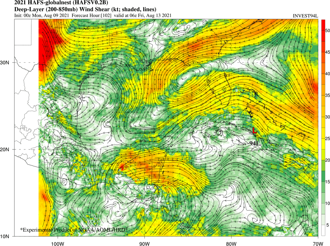
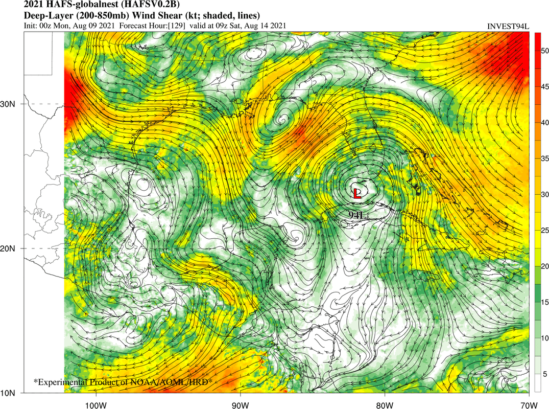
Re: ATL: 94L - Models
Current shear map

1 likes
M a r k
- - - - -
Join us in chat: Storm2K Chatroom Invite. Android and IOS apps also available.
The posts in this forum are NOT official forecasts and should not be used as such. Posts are NOT endorsed by any professional institution or STORM2K.org. For official information and forecasts, please refer to NHC and NWS products.
- - - - -
Join us in chat: Storm2K Chatroom Invite. Android and IOS apps also available.
The posts in this forum are NOT official forecasts and should not be used as such. Posts are NOT endorsed by any professional institution or STORM2K.org. For official information and forecasts, please refer to NHC and NWS products.
-
tolakram
- Admin
- Posts: 20186
- Age: 62
- Joined: Sun Aug 27, 2006 8:23 pm
- Location: Florence, KY (name is Mark)
Re: ATL: 94L - Models
This page appears to have replaced TCGEN for those looking for model track comparisons.
https://ruc.noaa.gov/tracks/
https://ruc.noaa.gov/tracks/
1 likes
M a r k
- - - - -
Join us in chat: Storm2K Chatroom Invite. Android and IOS apps also available.
The posts in this forum are NOT official forecasts and should not be used as such. Posts are NOT endorsed by any professional institution or STORM2K.org. For official information and forecasts, please refer to NHC and NWS products.
- - - - -
Join us in chat: Storm2K Chatroom Invite. Android and IOS apps also available.
The posts in this forum are NOT official forecasts and should not be used as such. Posts are NOT endorsed by any professional institution or STORM2K.org. For official information and forecasts, please refer to NHC and NWS products.
-
SFLcane

- S2K Supporter
- Posts: 10281
- Age: 48
- Joined: Sat Jun 05, 2010 1:44 pm
- Location: Lake Worth Florida
Re: ATL: 94L - Models
Blown Away wrote:https://i.imgur.com/w5ykJaO.jpg
12z shifted back NE slightly through 72 hours and big jump afterwards...
Yea, but if it were to take that exact track there will be nothing left. From what it looks like mow even if it misses the islands the ULL will prevent significant deepening.
2 likes
-
Blown Away
- S2K Supporter
- Posts: 10253
- Joined: Wed May 26, 2004 6:17 am
Re: ATL: 94L - Models
SFLcane wrote:Blown Away wrote:https://i.imgur.com/w5ykJaO.jpg
12z shifted back NE slightly through 72 hours and big jump afterwards...
Yea, but if it were to take that exact track there will be nothing left. From what it looks like mow even if it misses the islands the ULL will prevent significant deepening.

Agree, but into Hispaniola not set in stone.
0 likes
Hurricane Eye Experience: David 79, Irene 99, Frances 04, Jeanne 04, Wilma 05… Hurricane Brush Experience: Andrew 92, Erin 95, Floyd 99, Matthew 16, Irma 17, Ian 22, Nicole 22…
-
AlphaToOmega
- Category 5
- Posts: 1448
- Joined: Sat Jun 26, 2021 10:51 am
- Location: Somewhere in Massachusetts
Re: ATL: 94L - Models
One thing that the SHIPS model has been trending down is on shear down the road. Yesterday it was showing shear in the mid to upper 20 knots, now is down to upper teens to near 20 at the most.

5 likes
-
Hypercane_Kyle

- Category 5
- Posts: 3465
- Joined: Sat Mar 07, 2015 7:58 pm
- Location: Cape Canaveral, FL
Re: ATL: 94L - Models
IMHO, I think the models are overdoing it as far as hostile conditions out in the Bahamas. I do expect some sort of weak TS to survive should it manage to avoid Hispaniola.
0 likes
My posts are my own personal opinion, defer to the National Hurricane Center (NHC) and other NOAA products for decision making during hurricane season.
-
SFLcane
- S2K Supporter
- Posts: 10281
- Age: 48
- Joined: Sat Jun 05, 2010 1:44 pm
- Location: Lake Worth Florida
Re: ATL: 94L - Models
NDG wrote:One thing that the SHIPS model has been trending down is on shear down the road. Yesterday it was showing shear in the mid to upper 20 knots, now is down to upper teens to near 20 at the most.
https://i.imgur.com/5sqpPi1.gif
Now this is interesting.
0 likes
Who is online
Users browsing this forum: No registered users and 32 guests