https://twitter.com/DerekOrtt/status/1424949651527061504
Gulf coast better hope it recurves into Florida/gets shredded or else its going to have that Loop current I mentioned earlier to play with
ATL: FRED - Post-Tropical - Discussion
Moderator: S2k Moderators
-
Keldeo1997
- Category 2

- Posts: 688
- Joined: Fri Oct 11, 2019 11:35 pm

Re: ATL: SIX - Potential Tropical Cyclone - Discussion
A few over shooting cloud top, maybe near or right on top off the centre now
0 likes
-
StPeteMike

- Category 2
- Posts: 656
- Joined: Thu Jun 07, 2018 11:26 pm
Re: ATL: SIX - Potential Tropical Cyclone - Discussion
Although starting off in a location further south and from a different angle, not to mention a month earlier, getting Irma vibes…
0 likes
The above post is not official and should not be used as such. It is the opinion of the poster and may or may not be backed by sound meteorological data. It is not endorsed by any professional institution or storm2k.org. For official information, please refer to the NHC and NWS products.
-
skyline385

- Category 5

- Posts: 2728
- Age: 35
- Joined: Wed Aug 26, 2020 11:15 pm
- Location: Houston TX
Re: ATL: SIX - Potential Tropical Cyclone - Discussion
StPeteMike wrote:Although starting off in a location further south and from a different angle, not to mention a month earlier, getting Irma vibes…
Irma was RI'ing as soon as it crossed Verde islands, this is not even close to it....
5 likes
-
ElectricStorm

- Category 5
- Posts: 5148
- Age: 25
- Joined: Tue Aug 13, 2019 11:23 pm
- Location: Norman, OK
Re: ATL: SIX - Potential Tropical Cyclone - Discussion
skyline385 wrote:StPeteMike wrote:Although starting off in a location further south and from a different angle, not to mention a month earlier, getting Irma vibes…
Irma was RI'ing as soon as it crossed Verde islands, this is not even close to it....
Pretty sure he means track-wise into FL, not intensity.
1 likes
B.S Meteorology, University of Oklahoma '25
Please refer to the NHC, NWS, or SPC for official information.
Please refer to the NHC, NWS, or SPC for official information.
-
skyline385
- Category 5
- Posts: 2728
- Age: 35
- Joined: Wed Aug 26, 2020 11:15 pm
- Location: Houston TX
Re: ATL: SIX - Potential Tropical Cyclone - Discussion
Weather Dude wrote:skyline385 wrote:StPeteMike wrote:Although starting off in a location further south and from a different angle, not to mention a month earlier, getting Irma vibes…
Irma was RI'ing as soon as it crossed Verde islands, this is not even close to it....
Pretty sure he means track-wise into FL, not intensity.
Well this isnt a very uncommon path tho lol
3 likes
Re: ATL: SIX - Potential Tropical Cyclone - Discussion
Track and intensity around FL may be more Elsa like than Irma. We tend to reach for memorable storms and forget the snoozers even when they're more recent.
6 likes
-
StPeteMike
- Category 2
- Posts: 656
- Joined: Thu Jun 07, 2018 11:26 pm
Re: ATL: SIX - Potential Tropical Cyclone - Discussion
skyline385 wrote:Weather Dude wrote:skyline385 wrote:
Irma was RI'ing as soon as it crossed Verde islands, this is not even close to it....
Pretty sure he means track-wise into FL, not intensity.
Well this isnt a very uncommon path tho lol
Thanks Weather Dude haha just comparing by track. Actually been going through the model thread for Irma and look at the progression of the models. August 31, Irma was anywhere between SFL to Maine… so we still have time. Though I believe once I get to the Sept 5 models, right when Irma was closer to the LA, models were more committed to a SFL landfall.
0 likes
The above post is not official and should not be used as such. It is the opinion of the poster and may or may not be backed by sound meteorological data. It is not endorsed by any professional institution or storm2k.org. For official information, please refer to the NHC and NWS products.
-
skyline385
- Category 5
- Posts: 2728
- Age: 35
- Joined: Wed Aug 26, 2020 11:15 pm
- Location: Houston TX
Re: ATL: SIX - Potential Tropical Cyclone - Discussion
Every run moves it further west.
First, it was forecast to move to sea and maybe graze the Carolinas.
Then, it was an east coast landfall.
Then, a West Coast landfall.
Now 0Z GFS shows a Panhandle landfall as a Cat 2.
If it moves anymore West, then its gonna have even more time in the Gulf waters which are extremely hot right now.
First, it was forecast to move to sea and maybe graze the Carolinas.
Then, it was an east coast landfall.
Then, a West Coast landfall.
Now 0Z GFS shows a Panhandle landfall as a Cat 2.
If it moves anymore West, then its gonna have even more time in the Gulf waters which are extremely hot right now.
3 likes
-
ElectricStorm
- Category 5
- Posts: 5148
- Age: 25
- Joined: Tue Aug 13, 2019 11:23 pm
- Location: Norman, OK
Re: ATL: SIX - Potential Tropical Cyclone - Discussion
Nice little anticyclone sitting right over it. So shear shouldn't be an issue as long as it stays that way.

1 likes
B.S Meteorology, University of Oklahoma '25
Please refer to the NHC, NWS, or SPC for official information.
Please refer to the NHC, NWS, or SPC for official information.
-
storminabox
- Category 1

- Posts: 263
- Joined: Sun Jul 09, 2017 10:50 pm
Re: ATL: SIX - Potential Tropical Cyclone - Discussion
PTC 6 is so weak that the islands may not have as much of an impact as they would on a well developed tropical cyclone.
2 likes
-
ElectricStorm
- Category 5
- Posts: 5148
- Age: 25
- Joined: Tue Aug 13, 2019 11:23 pm
- Location: Norman, OK
Re: ATL: SIX - Potential Tropical Cyclone - Discussion
BULLETIN
Potential Tropical Cyclone Six Intermediate Advisory Number 2A
NWS National Hurricane Center Miami FL AL062021
200 AM AST Tue Aug 10 2021
...DISTURBANCE PASSING NEAR DOMINICA...
...HEAVY RAINS AND GUSTY WINDS CONTINUING TO SPREAD ACROSS THE
LEEWARD ISLANDS...
SUMMARY OF 200 AM AST...0600 UTC...INFORMATION
----------------------------------------------
LOCATION...15.5N 61.5W
ABOUT 55 MI...90 KM S OF GUADELOUPE
MAXIMUM SUSTAINED WINDS...35 MPH...55 KM/H
PRESENT MOVEMENT...WNW OR 295 DEGREES AT 16 MPH...26 KM/H
MINIMUM CENTRAL PRESSURE...1010 MB...29.83 INCHES
0 likes
B.S Meteorology, University of Oklahoma '25
Please refer to the NHC, NWS, or SPC for official information.
Please refer to the NHC, NWS, or SPC for official information.


Re: ATL: SIX - Potential Tropical Cyclone - Discussion
Looking at current radar, seems a center is trying to form just off the NW corner of Martinique.
https://www.barbadosweather.org/Composite/kidbuuComposite_Lionel_displayer2.php?Product=Reflectivity&Sector=EC_Bar&Composite=Sabre&ANISP=700&MAPP=1&PlanetOfTheApes=1628574352
https://www.barbadosweather.org/Composite/kidbuuComposite_Lionel_displayer2.php?Product=Reflectivity&Sector=EC_Bar&Composite=Sabre&ANISP=700&MAPP=1&PlanetOfTheApes=1628574352
1 likes
Re: ATL: SIX - Potential Tropical Cyclone - Discussion
Weather Dude wrote:BULLETIN
Potential Tropical Cyclone Six Intermediate Advisory Number 2A
NWS National Hurricane Center Miami FL AL062021
200 AM AST Tue Aug 10 2021
...DISTURBANCE PASSING NEAR DOMINICA...
...HEAVY RAINS AND GUSTY WINDS CONTINUING TO SPREAD ACROSS THE
LEEWARD ISLANDS...
SUMMARY OF 200 AM AST...0600 UTC...INFORMATION
----------------------------------------------
LOCATION...15.5N 61.5W
ABOUT 55 MI...90 KM S OF GUADELOUPE
MAXIMUM SUSTAINED WINDS...35 MPH...55 KM/H
PRESENT MOVEMENT...WNW OR 295 DEGREES AT 16 MPH...26 KM/H
MINIMUM CENTRAL PRESSURE...1010 MB...29.83 INCHES
Based on this my "centre-fix" is .7 deg too far south. I have mine 14.8/61.5. Hmmm...
0 likes
-
StPeteMike
- Category 2
- Posts: 656
- Joined: Thu Jun 07, 2018 11:26 pm
Re: ATL: SIX - Potential Tropical Cyclone - Discussion
LemieT wrote:Looking at current radar, seems a center is trying to form just off the NW corner of Martinique.
https://www.barbadosweather.org/Composite/kidbuuComposite_Lionel_displayer2.php?Product=Reflectivity&Sector=EC_Bar&Composite=Sabre&ANISP=700&MAPP=1&PlanetOfTheApes=1628574352
Correct, may be tightening up a little there as well.
0 likes
The above post is not official and should not be used as such. It is the opinion of the poster and may or may not be backed by sound meteorological data. It is not endorsed by any professional institution or storm2k.org. For official information, please refer to the NHC and NWS products.

Re: ATL: SIX - Potential Tropical Cyclone - Discussion
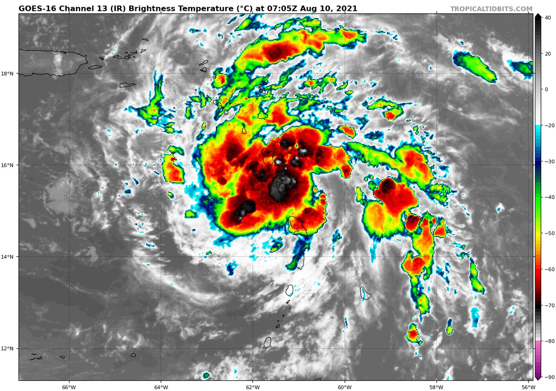
Looking much better early this morning, it might already be a storm..dmax now, we will see if this convection will sustain itself throughout the day.
Unless it goes poof, I expect recon to find a storm.
Unless it goes poof, I expect recon to find a storm.
0 likes
-
Kingarabian

- S2K Supporter

- Posts: 16373
- Joined: Sat Aug 08, 2009 3:06 am
- Location: Honolulu, Hawaii
Re: ATL: SIX - Potential Tropical Cyclone - Discussion
Yeah should be a TS when recon gets in:
3 likes
RIP Kobe Bryant
-
Shell Mound
- Category 5
- Posts: 2432
- Age: 33
- Joined: Thu Sep 07, 2017 3:39 pm
- Location: St. Petersburg, FL → Scandinavia
Re: ATL: SIX - Potential Tropical Cyclone - Discussion
1 likes
CVW / MiamiensisWx / Shell Mound
The posts in this forum are NOT official forecasts and should not be used as such. They are just the opinion of the poster and may or may not be backed by sound meteorological data. They are NOT endorsed by any professional institution or STORM2K. For official information, please refer to products from the NHC and NWS.
-
Shell Mound
- Category 5
- Posts: 2432
- Age: 33
- Joined: Thu Sep 07, 2017 3:39 pm
- Location: St. Petersburg, FL → Scandinavia
Re: ATL: SIX - Potential Tropical Cyclone - Discussion
Personally, I think the faster-than-expected forward speed in the short term will likely cap any further organisation until PTC Six nears the eastern Gulf.
0 likes
CVW / MiamiensisWx / Shell Mound
The posts in this forum are NOT official forecasts and should not be used as such. They are just the opinion of the poster and may or may not be backed by sound meteorological data. They are NOT endorsed by any professional institution or STORM2K. For official information, please refer to products from the NHC and NWS.
-
AtlanticWind

- S2K Supporter
- Posts: 1898
- Age: 67
- Joined: Sun Aug 08, 2004 9:57 pm
- Location: Plantation,Fla
Re: ATL: SIX - Potential Tropical Cyclone - Discussion
Shell Mound wrote:Personally, I think the faster-than-expected forward speed in the short term will likely cap any further organisation until PTC Six nears the eastern Gulf.
Its speed of about 16mph should be no hindrance
5 likes
Who is online
Users browsing this forum: No registered users and 10 guests