ATL: FRED - Post-Tropical - Discussion
Moderator: S2k Moderators

Re: ATL: FRED - Tropical Depression - Discussion
Forecaster Stewart always has the best NHC Forecast Discussions, worth staying up late to read his.
10 likes
-
AutoPenalti
- Category 5

- Posts: 4091
- Age: 29
- Joined: Mon Aug 17, 2015 4:16 pm
- Location: Ft. Lauderdale, Florida
Re: ATL: FRED - Tropical Depression - Discussion
NDG wrote:Forecaster Stewart always has the best NHC Forecast Discussions, worth staying up late to read his.
Yeah he does, some here claim he’s too bullish sometimes but he’s done an outstanding job explaining his reasonings.
6 likes
The posts in this forum are NOT official forecasts and should not be used as such. They are just the opinion of the poster and may or may not be backed by sound meteorological data. They are NOT endorsed by any professional institution or STORM2K. For official information, please refer to products from the NHC and NWS.
Model Runs Cheat Sheet:
GFS (5:30 AM/PM, 11:30 AM/PM)
HWRF, GFDL, UKMET, NAVGEM (6:30-8:00 AM/PM, 12:30-2:00 AM/PM)
ECMWF (1:45 AM/PM)
TCVN is a weighted averaged
Re: ATL: FRED - Tropical Depression - Discussion
From the 11PM Discussion "There is one caveat, however, and that is the ECMWF model forecasting the shear to weaken to 5-10 kt during the 36-72 hour period, which could allow for a little more strengthening than what the official orecast is currently indicating. "
This is the reason I think things will change quickly on Friday, the shift to ridging here is very interesting. Tomorrow I could probably just skip since it'll probably be folks competing on where the "center" is and armchair yelling at recon planes to check random different spots.
This is the reason I think things will change quickly on Friday, the shift to ridging here is very interesting. Tomorrow I could probably just skip since it'll probably be folks competing on where the "center" is and armchair yelling at recon planes to check random different spots.
Last edited by BobHarlem on Wed Aug 11, 2021 10:17 pm, edited 1 time in total.
9 likes
-
AtlanticWind

- S2K Supporter

- Posts: 1898
- Age: 67
- Joined: Sun Aug 08, 2004 9:57 pm
- Location: Plantation,Fla
Re: ATL: FRED - Tropical Depression - Discussion
The first visibles in the morning should give us idea what shape Freds in.
0 likes

Re: ATL: FRED - Tropical Depression - Discussion
AtlanticWind wrote:The first visibles in the morning should give us idea what shape Freds in.
My guess, it will pushing inland near Guantanamo Bay and the large mountains of western Cuba. Maybe a depression maybe just showers for Northwester Florida
Looking at night time visible, what’s left of Fred seems to be moving into the gulf of Gonave
0 likes
The following post is NOT an official forecast and should not be used as such. It is just the opinion of the poster and may or may not be backed by sound meteorological data. It is NOT endorsed by any professional institution including storm2k.org For Official Information please refer to the NHC and NWS products.
-
AtlanticWind
- S2K Supporter
- Posts: 1898
- Age: 67
- Joined: Sun Aug 08, 2004 9:57 pm
- Location: Plantation,Fla
Re: ATL: FRED - Tropical Depression - Discussion
tailgater wrote:AtlanticWind wrote:The first visibles in the morning should give us idea what shape Freds in.
My guess, it will pushing inland near Guantanamo Bay and the large mountains of western Cuba. Maybe a depression maybe just showers for Northwester Florida
Looking at night time visible, what’s left of Fred seems to be moving into the gulf of Gonave
Looks to me to be on the north coast of Haiti
1 likes
-
Blown Away

- S2K Supporter
- Posts: 10253
- Joined: Wed May 26, 2004 6:17 am
Re: ATL: FRED - Tropical Depression - Discussion
AtlanticWind wrote:tailgater wrote:AtlanticWind wrote:The first visibles in the morning should give us idea what shape Freds in.
My guess, it will pushing inland near Guantanamo Bay and the large mountains of western Cuba. Maybe a depression maybe just showers for Northwester Florida
Looking at night time visible, what’s left of Fred seems to be moving into the gulf of Gonave
Looks to me to be on the north coast of Haiti
Sure does, a little convection bubble brewing just off the N coast, maybe??
4 likes
Hurricane Eye Experience: David 79, Irene 99, Frances 04, Jeanne 04, Wilma 05… Hurricane Brush Experience: Andrew 92, Erin 95, Floyd 99, Matthew 16, Irma 17, Ian 22, Nicole 22…
-
AtlanticWind
- S2K Supporter
- Posts: 1898
- Age: 67
- Joined: Sun Aug 08, 2004 9:57 pm
- Location: Plantation,Fla
Re: ATL: FRED - Tropical Depression - Discussion
Convection expanding on the north and northeast side
Could it be the comeback?
Could it be the comeback?
0 likes
-
AutoPenalti
- Category 5
- Posts: 4091
- Age: 29
- Joined: Mon Aug 17, 2015 4:16 pm
- Location: Ft. Lauderdale, Florida
Re: ATL: FRED - Tropical Depression - Discussion
AtlanticWind wrote:Convection expanding on the north and northeast side
Could it be the comeback?
DMAX aiding in convection.
0 likes
The posts in this forum are NOT official forecasts and should not be used as such. They are just the opinion of the poster and may or may not be backed by sound meteorological data. They are NOT endorsed by any professional institution or STORM2K. For official information, please refer to products from the NHC and NWS.
Model Runs Cheat Sheet:
GFS (5:30 AM/PM, 11:30 AM/PM)
HWRF, GFDL, UKMET, NAVGEM (6:30-8:00 AM/PM, 12:30-2:00 AM/PM)
ECMWF (1:45 AM/PM)
TCVN is a weighted averaged
-
AxaltaRacing24
- Category 5
- Posts: 1774
- Age: 25
- Joined: Wed Jul 27, 2016 11:14 am
- Location: Jupiter, FL
Re: ATL: FRED - Tropical Depression - Discussion
AtlanticWind wrote:Convection expanding on the north and northeast side
Could it be the comeback?
The northern convection should increase, while the MLC slowly diminishes over the DR.
0 likes
-
AtlanticWind
- S2K Supporter
- Posts: 1898
- Age: 67
- Joined: Sun Aug 08, 2004 9:57 pm
- Location: Plantation,Fla
Re: ATL: FRED - Tropical Depression - Discussion
I noticed the convection bending in north of the D.R. looks like a circulation
Relocation?
Relocation?
0 likes
-
Hurricaneman

- Category 5
- Posts: 7404
- Age: 45
- Joined: Tue Aug 31, 2004 3:24 pm
- Location: central florida
Re: ATL: FRED - Tropical Depression - Discussion
AtlanticWind wrote:I noticed the convection bending in north of the D.R. looks like a circulation
Relocation?
Possibly as things like that are possible with LLCs and Hispaniola
0 likes
-
ElectricStorm

- Category 5
- Posts: 5148
- Age: 25
- Joined: Tue Aug 13, 2019 11:23 pm
- Location: Norman, OK
Re: ATL: FRED - Tropical Depression - Discussion
BULLETIN
Tropical Depression Fred Intermediate Advisory Number 10A
NWS National Hurricane Center Miami FL AL062021
200 AM EDT Thu Aug 12 2021
...DISORGANIZED FRED OVER NORTHWESTERN HAITI...
...HEAVY RAINS CONTINUE ACROSS PORTIONS OF HISPANIOLA...
SUMMARY OF 200 AM EDT...0600 UTC...INFORMATION
----------------------------------------------
LOCATION...19.8N 72.8W
ABOUT 90 MI...150 KM SSE OF GREAT INAGUA ISLAND
ABOUT 160 MI...255 KM E OF GUANTANAMO CUBA
MAXIMUM SUSTAINED WINDS...35 MPH...55 KM/H
PRESENT MOVEMENT...WNW OR 300 DEGREES AT 15 MPH...24 KM/H
MINIMUM CENTRAL PRESSURE...1009 MB...29.80 INCHES
0 likes
B.S Meteorology, University of Oklahoma '25
Please refer to the NHC, NWS, or SPC for official information.
Please refer to the NHC, NWS, or SPC for official information.

Re: ATL: FRED - Tropical Depression - Discussion
BobHarlem wrote: Tomorrow I could probably just skip since it'll probably be folks competing on where the "center" is and armchair yelling at recon planes to check random different spots.
6 likes
Andy D
(For official information, please refer to the NHC and NWS products.)
(For official information, please refer to the NHC and NWS products.)
-
AdamFirst

- S2K Supporter
- Posts: 2490
- Age: 36
- Joined: Thu Aug 14, 2008 10:54 am
- Location: Port Saint Lucie, FL
Re: ATL: FRED - Tropical Depression - Discussion
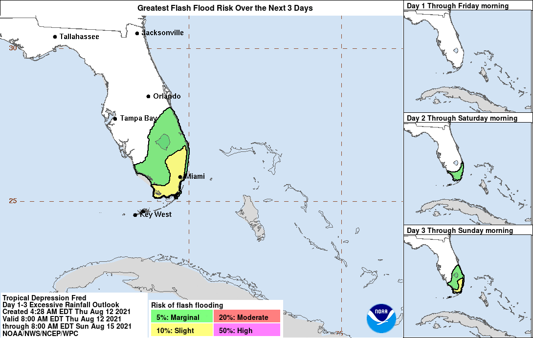
Tropical Depression Fred Discussion Number 11
NWS National Hurricane Center Miami FL AL062021
500 AM EDT Thu Aug 12 2021
The rugged terrain of Hispaniola has taken a toll on Fred.
Satellite images and surface observations indicate that the
circulation is stretched out and seems to resemble a trough at the
surface. The system is now emerging back over water and is located
between Haiti, eastern Cuba, and the southeastern Bahamas. Most of
the associated showers and thunderstorms are located to the east of
the estimated center, with heavy rains continuing over portions of
Hispaniola. The initial intensity is estimated to be 30 kt, but
there is limited data to confirm this. Both the NOAA and Air Force
Hurricane Hunters will be investigating Fred later this morning, and
the data from both planes will be helpful in estimating Fred's
strength and structure.
Fred appears to be moving west-northwestward at about 14 kt. The
track forecast reasoning has not changed much. A subtropical
ridge currently situated to the north of Fred over the western
Atlantic should continue to steer the system west-northwestward for
the next 36 to 48 hours. This motion should take the storm just
north of or across Cuba and the southeastern Bahamas during that
time period. By the weekend, the models suggest that Fred will
be rounding the western periphery of the ridge, which will likely a
cause a slow down and a gradual turn to the northwest and then the
north across portions of the Florida Keys, the Florida peninsula,
and the eastern Gulf of Mexico. There is uncertainty in exactly
where and when Fred will make that turn to the right, with models
currently spanning a region from over Florida to the east-central
Gulf of Mexico. The NHC track forecast remains on the right side
of the guidance envelope, near the typically more skillful global
models and consensus aids.
0 likes
Dolphins Marlins Canes Golden Panthers HEAT
Andrew 1992 - Irene 1999 - Frances 2004 - Jeanne 2004 - Wilma 2005 - Fay 2008 - Isaac 2012 - Matthew 2016 - Irma 2017 - Dorian 2019 - Ian 2022 - Nicole 2022 - Milton 2024
Andrew 1992 - Irene 1999 - Frances 2004 - Jeanne 2004 - Wilma 2005 - Fay 2008 - Isaac 2012 - Matthew 2016 - Irma 2017 - Dorian 2019 - Ian 2022 - Nicole 2022 - Milton 2024

Re: ATL: FRED - Tropical Depression - Discussion
I'm seeing a naked swirl around the Inagua Islands, Mathew Town quickly pulling away from the rest of the convection.
Tough to say if this area will die off or become the dominant LLC, if it can start feeding some convection soon then Fred will.likely make a speedy comeback(from a minimal TS...). If this area dies off, then Fred will likely become a trough of low pressure and won't reform until Friday if at all.
Just my amateur speculation.
0 likes
-
beoumont

- Category 1

- Posts: 473
- Joined: Sun Jul 10, 2011 4:13 pm
- Location: East Central Florida
- Contact:
Re: ATL: FRED - Tropical Depression - Discussion
Satellite enhancement of Fred on the Dr. Dvorkian scale.
Per MASH: suicide is painless
It brings on many changes.

Per MASH: suicide is painless
It brings on many changes.
1 likes
List of 79 tropical cyclones intercepted by Richard Horodner:
http://www.canebeard.com/page/page/572246.htm
http://www.canebeard.com/page/page/572246.htm
-
AlphaToOmega
- Category 5
- Posts: 1448
- Joined: Sat Jun 26, 2021 10:51 am
- Location: Somewhere in Massachusetts
-
AlphaToOmega
- Category 5
- Posts: 1448
- Joined: Sat Jun 26, 2021 10:51 am
- Location: Somewhere in Massachusetts
-
Weatherboy1

- Category 5
- Posts: 1190
- Age: 50
- Joined: Mon Jul 05, 2004 1:50 pm
- Location: Jupiter/Sarasota, FL
Re: ATL: FRED - Tropical Depression - Discussion
Jr0d wrote:I'm seeing a naked swirl around the Inagua Islands, Mathew Town quickly pulling away from the rest of the convection.
Tough to say if this area will die off or become the dominant LLC, if it can start feeding some convection soon then Fred will.likely make a speedy comeback(from a minimal TS...). If this area dies off, then Fred will likely become a trough of low pressure and won't reform until Friday if at all.
Just my amateur speculation.
That was my feeling/guess too. Will see what visible say shows in a bit. Probably dead soon if that is the “center” but never say never.
0 likes
Who is online
Users browsing this forum: No registered users and 15 guests