ATL: GRACE - Models
Moderator: S2k Moderators
Re: ATL: 95L - Models
HWRF develops 95L late in the run well south of Haiti and the DR. The Euro still shows development and is a little further south compared to the 12Z run passing just to the south of PR.
0 likes

Re: ATL: 95L - Models
It's all good GFS Takes this through as an open wave after PR on the 06z but at 360h that tail end of the trough seems promising  , I think after 95L gets past 50W we might have some more consensus.
0 likes
Once I see the REDS and GREENS Converge on a Base Velocity. ... I'm There!!
This is NOT an Official Forecast....Just my Opinion. For official information, please refer to the NHC and NWS products.
HIGHLIGHTS : '13 El Reno Tornado : 2013 Storm Chaser Tour, Joaquin; SC flood event, Matthew '16, Lowcountry Snow storm Jan '18
This is NOT an Official Forecast....Just my Opinion. For official information, please refer to the NHC and NWS products.
HIGHLIGHTS : '13 El Reno Tornado : 2013 Storm Chaser Tour, Joaquin; SC flood event, Matthew '16, Lowcountry Snow storm Jan '18
-
Spacecoast

- Category 2

- Posts: 773
- Joined: Thu Aug 31, 2017 2:03 pm
Re: ATL: 95L - Models
0z ECMF ensembles very tightly clustered through 72-96 hrs

0z ECMF Density - Seems convinced of genesis


0z ECMF Density - Seems convinced of genesis
Last edited by Spacecoast on Thu Aug 12, 2021 11:20 am, edited 1 time in total.
0 likes
Re: ATL: 95L - Models
Spacecoast wrote:0z ECMF ensembles very tightly clustered through 72-96 hrs
[url]https://i.ibb.co/qj0wQS9/ecmdn.jpg [/url]
0z ECMF Density - Seems convinced of genesis
[url]https://i.ibb.co/Kwv7HWC/ecmdm.jpg [/url]
interesting, suggestive of strong ridging over the ATL
0 likes
Once I see the REDS and GREENS Converge on a Base Velocity. ... I'm There!!
This is NOT an Official Forecast....Just my Opinion. For official information, please refer to the NHC and NWS products.
HIGHLIGHTS : '13 El Reno Tornado : 2013 Storm Chaser Tour, Joaquin; SC flood event, Matthew '16, Lowcountry Snow storm Jan '18
This is NOT an Official Forecast....Just my Opinion. For official information, please refer to the NHC and NWS products.
HIGHLIGHTS : '13 El Reno Tornado : 2013 Storm Chaser Tour, Joaquin; SC flood event, Matthew '16, Lowcountry Snow storm Jan '18

Re: ATL: 95L - Models
Does the GFS finally do something with it on August 21st? Looks like it's out there off the east coast.
0 likes
Personal Forecast Disclaimer:
The posts in this forum are NOT official forecast and should not be used as such. They are just the opinion of the poster and may or may not be backed by sound meteorological data. They are NOT endorsed by any professional institution or storm2k.org. For official information, please refer to the NHC and NWS products.
The posts in this forum are NOT official forecast and should not be used as such. They are just the opinion of the poster and may or may not be backed by sound meteorological data. They are NOT endorsed by any professional institution or storm2k.org. For official information, please refer to the NHC and NWS products.
-
cycloneye

- Admin

- Posts: 149550
- Age: 69
- Joined: Thu Oct 10, 2002 10:54 am
- Location: San Juan, Puerto Rico
Re: ATL: 95L - Models
SoupBone wrote:Does the GFS finally do something with it on August 21st? Looks like it's out there off the east coast.
Yes. That is 95L very strong.

2 likes
Visit the Caribbean-Central America Weather Thread where you can find at first post web cams,radars
and observations from Caribbean basin members Click Here
and observations from Caribbean basin members Click Here


-
gatorcane

- S2K Supporter

- Posts: 23708
- Age: 48
- Joined: Sun Mar 13, 2005 3:54 pm
- Location: Boca Raton, FL
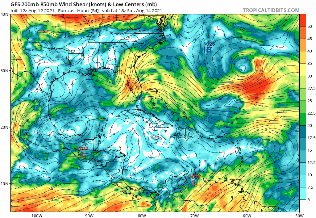
Re: ATL: 95L - Models
TUTT awaits 95l once it gets further west by the Lesser Antilles - that is some serious shear if the GFS is correct:
0 likes
-
AutoPenalti
- Category 5

- Posts: 4091
- Age: 29
- Joined: Mon Aug 17, 2015 4:16 pm
- Location: Ft. Lauderdale, Florida
Re: ATL: 95L - Models
gatorcane wrote:TUTT awaits 95l once it gets further west by the Lesser Antilles - that is some serious shear if the GFS is correct:
https://i.postimg.cc/hPDDPyKs/gfs-shear-watl-fh54-144.gif
So Fred decides to loop around the Panhandle?
Okay.
0 likes
The posts in this forum are NOT official forecasts and should not be used as such. They are just the opinion of the poster and may or may not be backed by sound meteorological data. They are NOT endorsed by any professional institution or STORM2K. For official information, please refer to products from the NHC and NWS.
Model Runs Cheat Sheet:
GFS (5:30 AM/PM, 11:30 AM/PM)
HWRF, GFDL, UKMET, NAVGEM (6:30-8:00 AM/PM, 12:30-2:00 AM/PM)
ECMWF (1:45 AM/PM)
TCVN is a weighted averaged

Re: ATL: 95L - Models
NDG wrote:Models have been horrible, including the Euro with 95L.
The Euro has apparently done the best with 95L so far, which is a sentence I never thought I would say after 2020. It correctly predicted the more active and dominant northern lobe that we’ve seen today.
0 likes
Irene '11 Sandy '12 Hermine '16 5/15/2018 Derecho Fay '20 Isaias '20 Elsa '21 Henri '21 Ida '21
I am only a meteorology enthusiast who knows a decent amount about tropical cyclones. Look to the professional mets, the NHC, or your local weather office for the best information.
I am only a meteorology enthusiast who knows a decent amount about tropical cyclones. Look to the professional mets, the NHC, or your local weather office for the best information.
-
gatorcane
- S2K Supporter
- Posts: 23708
- Age: 48
- Joined: Sun Mar 13, 2005 3:54 pm
- Location: Boca Raton, FL
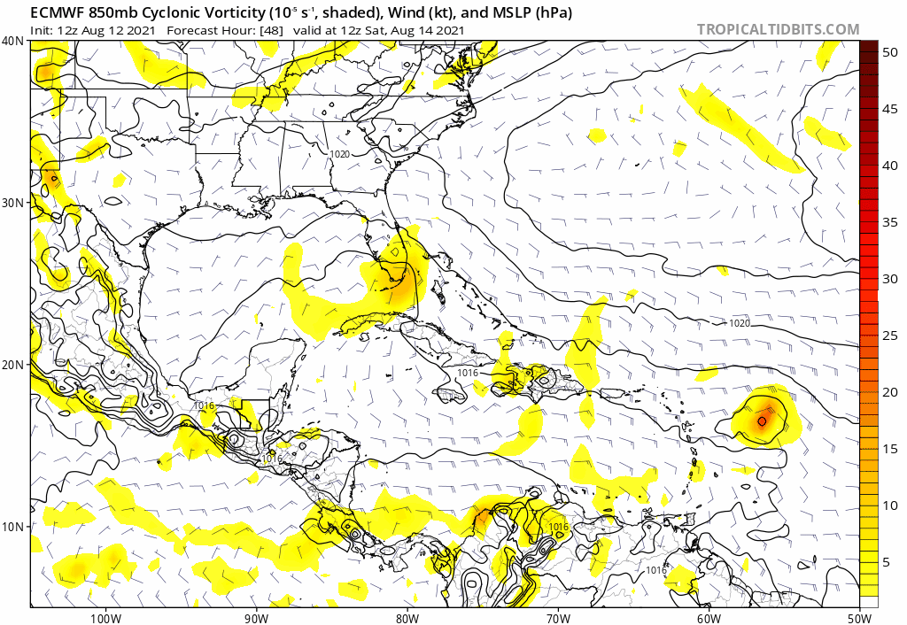
Re: ATL: 95L - Models
The steering is there for a classic South Florida strike on the 12Z Euro but it is showing unfavorable conditions in this run thankfully:
0 likes
-
AutoPenalti
- Category 5
- Posts: 4091
- Age: 29
- Joined: Mon Aug 17, 2015 4:16 pm
- Location: Ft. Lauderdale, Florida
Re: ATL: 95L - Models
gatorcane wrote:The steering is there for a classic South Florida strike on the 12Z Euro but it is showing unfavorable conditions in this run thankfully:
https://i.postimg.cc/wv5SJz9r/ecmwf-uv850-vort-watl-fh48-168.gif
It's not showing unfavorable conditions, it just happens to slam PR and DR again.
3 likes
The posts in this forum are NOT official forecasts and should not be used as such. They are just the opinion of the poster and may or may not be backed by sound meteorological data. They are NOT endorsed by any professional institution or STORM2K. For official information, please refer to products from the NHC and NWS.
Model Runs Cheat Sheet:
GFS (5:30 AM/PM, 11:30 AM/PM)
HWRF, GFDL, UKMET, NAVGEM (6:30-8:00 AM/PM, 12:30-2:00 AM/PM)
ECMWF (1:45 AM/PM)
TCVN is a weighted averaged
-
Kingarabian

- S2K Supporter
- Posts: 16373
- Joined: Sat Aug 08, 2009 3:06 am
- Location: Honolulu, Hawaii
Re: ATL: 95L - Models
Even before the 2020 model debacle, the models failed to key in on significant systems 72 hours before they formed in Michael 2016 and Harvey 2017. So it's always best to look at ALL the guidance, especially ensembles.
4 likes
RIP Kobe Bryant
-
cycloneye
- Admin
- Posts: 149550
- Age: 69
- Joined: Thu Oct 10, 2002 10:54 am
- Location: San Juan, Puerto Rico
Re: ATL: 95L - Models
12z HWRF is running late.
0 likes
Visit the Caribbean-Central America Weather Thread where you can find at first post web cams,radars
and observations from Caribbean basin members Click Here
and observations from Caribbean basin members Click Here
Re: ATL: 95L - Models
cycloneye wrote:12z HWRF is running late.
It finally shows development within the next 72 hours before reaching the islands. Nothing really strong, but it’s something.
Despite focusing on the dominant northern lobe, the HWRF shows minimal gain in latitude, and 95L enters the Caribbean around 16N — south of the Greater Antilles. Usually, the HWRF has a north bias, as seen with Laura, Eta, and Fred.
Last edited by aspen on Thu Aug 12, 2021 3:44 pm, edited 1 time in total.
0 likes
Irene '11 Sandy '12 Hermine '16 5/15/2018 Derecho Fay '20 Isaias '20 Elsa '21 Henri '21 Ida '21
I am only a meteorology enthusiast who knows a decent amount about tropical cyclones. Look to the professional mets, the NHC, or your local weather office for the best information.
I am only a meteorology enthusiast who knows a decent amount about tropical cyclones. Look to the professional mets, the NHC, or your local weather office for the best information.
-
AutoPenalti
- Category 5
- Posts: 4091
- Age: 29
- Joined: Mon Aug 17, 2015 4:16 pm
- Location: Ft. Lauderdale, Florida
Re: ATL: 95L - Models
HWRF doesn't really do much with it which is odd considering the favorable conditions it encounters. It heads due west towards the GA's.
Following the same path as Fred tbh.
Following the same path as Fred tbh.
0 likes
The posts in this forum are NOT official forecasts and should not be used as such. They are just the opinion of the poster and may or may not be backed by sound meteorological data. They are NOT endorsed by any professional institution or STORM2K. For official information, please refer to products from the NHC and NWS.
Model Runs Cheat Sheet:
GFS (5:30 AM/PM, 11:30 AM/PM)
HWRF, GFDL, UKMET, NAVGEM (6:30-8:00 AM/PM, 12:30-2:00 AM/PM)
ECMWF (1:45 AM/PM)
TCVN is a weighted averaged
-
AxaltaRacing24
- Category 5
- Posts: 1774
- Age: 25
- Joined: Wed Jul 27, 2016 11:14 am
- Location: Jupiter, FL
Re: ATL: 95L - Models
AutoPenalti wrote:HWRF doesn't really do much with it which is odd considering the favorable conditions it encounters. It heads due west towards the GA's.
Following the same path as Fred tbh.
It's down the 997 mb and still intensifying at hour 90.
0 likes
-
AutoPenalti
- Category 5
- Posts: 4091
- Age: 29
- Joined: Mon Aug 17, 2015 4:16 pm
- Location: Ft. Lauderdale, Florida
Re: ATL: 95L - Models
HWRF finds better conditions where Fred was but continues due W.
0 likes
The posts in this forum are NOT official forecasts and should not be used as such. They are just the opinion of the poster and may or may not be backed by sound meteorological data. They are NOT endorsed by any professional institution or STORM2K. For official information, please refer to products from the NHC and NWS.
Model Runs Cheat Sheet:
GFS (5:30 AM/PM, 11:30 AM/PM)
HWRF, GFDL, UKMET, NAVGEM (6:30-8:00 AM/PM, 12:30-2:00 AM/PM)
ECMWF (1:45 AM/PM)
TCVN is a weighted averaged
-
cycloneye
- Admin
- Posts: 149550
- Age: 69
- Joined: Thu Oct 10, 2002 10:54 am
- Location: San Juan, Puerto Rico
Re: ATL: 95L - Models
0 likes
Visit the Caribbean-Central America Weather Thread where you can find at first post web cams,radars
and observations from Caribbean basin members Click Here
and observations from Caribbean basin members Click Here
Who is online
Users browsing this forum: No registered users and 21 guests