CPAC: LINDA - Post-Tropical
Moderator: S2k Moderators
-
Kingarabian

- S2K Supporter

- Posts: 16367
- Joined: Sat Aug 08, 2009 3:06 am
- Location: Honolulu, Hawaii
Re: EPAC: LINDA - Hurricane
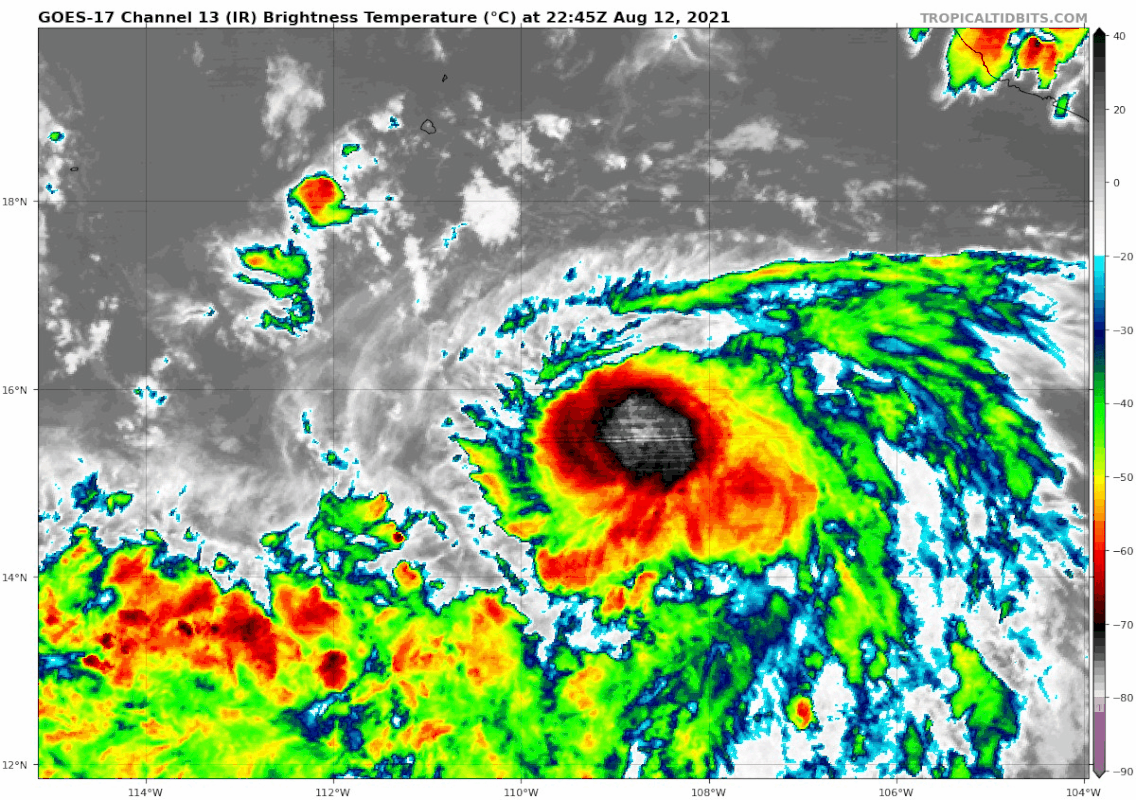
No major hiccups today. Let's see if it regresses with the sun going down over it.
0 likes
RIP Kobe Bryant
-
Yellow Evan

- Professional-Met

- Posts: 16240
- Age: 27
- Joined: Fri Jul 15, 2011 12:48 pm
- Location: Henderson, Nevada/Honolulu, HI
- Contact:
-
Yellow Evan
- Professional-Met
- Posts: 16240
- Age: 27
- Joined: Fri Jul 15, 2011 12:48 pm
- Location: Henderson, Nevada/Honolulu, HI
- Contact:

-
Kingarabian
- S2K Supporter
- Posts: 16367
- Joined: Sat Aug 08, 2009 3:06 am
- Location: Honolulu, Hawaii
-
Kingarabian
- S2K Supporter
- Posts: 16367
- Joined: Sat Aug 08, 2009 3:06 am
- Location: Honolulu, Hawaii
Re: EPAC: LINDA - Hurricane
UW - CIMSS
ADVANCED DVORAK TECHNIQUE
ADT-Version 9.0
Tropical Cyclone Intensity Algorithm
----- Current Analysis -----
Date : 13 AUG 2021 Time : 005020 UTC
Lat : 15:36:59 N Lon : 109:22:25 W
CI# /Pressure/ Vmax
4.6 / 977.5mb/ 79.6kt
Final T# Adj T# Raw T#
4.6 4.6 3.8
Center Temp : -58.4C Cloud Region Temp : -61.8C
Scene Type : UNIFORM CDO CLOUD REGION w/ MW EYE
Subtropical Adjustment : OFF
Extratropical Adjustment : OFF
Positioning Method : FORECAST INTERPOLATION
Ocean Basin : EAST PACIFIC
Dvorak CI > MSLP Conversion Used : CKZ Method
Tno/CI Rules : Constraint Limits : MW ON
Weakening Flag : OFF
Rapid Dissipation Flag : OFF
0 likes
RIP Kobe Bryant
-
Kingarabian
- S2K Supporter
- Posts: 16367
- Joined: Sat Aug 08, 2009 3:06 am
- Location: Honolulu, Hawaii
-
Yellow Evan
- Professional-Met
- Posts: 16240
- Age: 27
- Joined: Fri Jul 15, 2011 12:48 pm
- Location: Henderson, Nevada/Honolulu, HI
- Contact:
Re: EPAC: LINDA - Hurricane
* GFS version *
* EAST PACIFIC 2021 SHIPS INTENSITY FORECAST *
* IR SAT DATA AVAILABLE, OHC AVAILABLE *
* LINDA EP122021 08/13/21 00 UTC *
TIME (HR) 0 6 12 18 24 36 48 60 72 84 96 108 120 132 144 156 168
V (KT) NO LAND 70 72 75 79 80 82 81 78 77 75 75 72 69 64 59 54 48
V (KT) LAND 70 72 75 79 80 82 81 78 77 75 75 72 69 64 59 54 48
V (KT) LGEM 70 73 75 76 77 78 76 72 68 64 60 56 54 50 44 37 30
Storm Type TROP TROP TROP TROP TROP TROP TROP TROP TROP TROP TROP TROP TROP TROP TROP TROP TROP
SHEAR (KT) 14 17 16 11 6 5 8 11 11 9 6 3 4 7 5 5 6
SHEAR ADJ (KT) 1 2 0 0 2 3 1 0 -1 -2 -2 0 3 1 7 3 4
SHEAR DIR 359 11 16 28 23 62 63 77 49 53 46 67 198 243 193 201 201
SST (C) 28.6 28.5 28.3 27.9 27.8 27.8 26.6 26.5 25.9 25.3 24.7 25.0 25.1 24.2 23.9 22.5 22.0
POT. INT. (KT) 151 150 148 144 143 143 130 128 122 116 109 113 114 105 102 88 82
200 MB T (C) -53.5 -53.8 -53.9 -53.7 -53.2 -53.4 -52.8 -53.1 -52.7 -53.2 -52.6 -53.0 -52.3 -52.5 -52.3 -52.5 -52.2
200 MB VXT (C) 0.1 0.4 0.4 0.3 0.4 0.5 0.3 0.6 0.5 0.5 0.5 0.7 0.4 0.6 0.5 0.8 0.5
TH_E DEV (C) 5 5 5 5 6 5 5 4 4 3 3 3 3 2 2 1 1
700-500 MB RH 77 77 77 77 74 71 65 64 58 58 55 54 50 50 45 39 34
MODEL VTX (KT) 20 19 22 24 24 24 24 24 25 26 27 26 26 25 23 20 16
850 MB ENV VOR -16 -14 -17 -18 -20 -21 -18 -3 11 23 35 48 52 54 48 38 45
200 MB DIV 94 74 57 48 22 5 20 -10 18 -27 17 -10 -11 -22 9 -5 -9
700-850 TADV -12 -21 -18 -9 -1 1 2 4 1 3 2 1 1 2 3 4 5
LAND (KM) 606 654 700 681 682 760 843 991 1158 1315 1460 1611 1754 1866 1959 1986 1887
LAT (DEG N) 15.6 16.2 16.7 17.2 17.6 18.5 19.1 19.1 19.1 18.9 18.6 18.5 18.9 xx.x xx.x xx.x xx.x
LONG(DEG W) 109.1 110.2 111.2 112.3 113.3 115.6 117.7 119.7 121.7 123.5 125.2 127.1 129.2 xxx.x xxx.x xxx.x xxx.x
STM SPEED (KT) 11 11 11 11 11 11 10 9 9 9 9 9 9 10 10 12 12
HEAT CONTENT 14 12 11 9 8 7 1 1 0 0 0 0 0 0 0 0 0
FORECAST TRACK FROM OFCI INITIAL HEADING/SPEED (DEG/KT):300/ 10 CX,CY: -8/ 5
T-12 MAX WIND: 65 PRESSURE OF STEERING LEVEL (MB): 643 (MEAN=587)
GOES IR BRIGHTNESS TEMP. STD DEV. 50-200 KM RAD: 10.8 (MEAN=14.5)
% GOES IR PIXELS WITH T < -20 C 50-200 KM RAD: 83.0 (MEAN=65.0)
PRELIM RI PROB (DV .GE. 35 KT IN 36 HR): 22.2
INDIVIDUAL CONTRIBUTIONS TO INTENSITY CHANGE
6 12 18 24 36 48 60 72 84 96 108 120 132 144 156 168
------------------------------------------------------------------------------
SAMPLE MEAN CHANGE 0. 0. 1. 1. 1. 2. 1. 1. 0. -0. -1. -2. -2. -3. -4. -4.
SST POTENTIAL 1. 2. 3. 3. 3. 1. -2. -4. -6. -9. -11. -13. -15. -18. -22. -27.
VERTICAL SHEAR MAG -1. -2. -3. -2. -1. 0. 1. 2. 2. 3. 5. 6. 6. 6. 7. 7.
VERTICAL SHEAR ADJ -0. -0. -0. -0. -1. -1. -1. -0. -0. -0. -0. -0. -0. -0. -0. -0.
VERTICAL SHEAR DIR 0. 0. 0. 0. 1. 1. 1. 1. 1. 0. 0. -0. -1. -1. -1. -1.
PERSISTENCE 1. 1. 1. 1. 1. 0. 0. 0. 0. 0. -0. -0. -0. -0. -0. -0.
200/250 MB TEMP. 0. 0. 0. 0. 0. 0. 0. 1. 2. 2. 3. 3. 3. 4. 4. 5.
THETA_E EXCESS -0. -0. -0. -1. -1. -1. -2. -3. -3. -4. -5. -5. -6. -7. -8. -10.
700-500 MB RH 0. 0. 0. 1. 1. 1. 1. 1. 1. 1. 1. 0. 0. 0. -0. -1.
MODEL VTX TENDENCY -0. 1. 3. 3. 3. 4. 5. 7. 8. 9. 8. 7. 5. 2. -1. -3.
850 MB ENV VORTICITY -0. -0. -0. -0. -0. 0. 0. 1. 1. 1. 1. 1. 1. 1. 0. 0.
200 MB DIVERGENCE 0. 0. 0. 0. 0. -0. -1. -1. -2. -2. -2. -2. -2. -1. 0. 1.
850-700 T ADVEC 0. 0. 0. 0. 0. -0. -0. -0. -0. -0. -0. -0. -0. 0. 0. 0.
ZONAL STORM MOTION 0. 0. 0. 0. 0. 0. 0. 0. 0. 0. 0. 0. 0. 0. 0. -0.
STEERING LEVEL PRES 0. 0. 0. 0. 1. 1. 1. 1. 1. 1. 2. 2. 1. 1. 1. 0.
DAYS FROM CLIM. PEAK 0. 0. 0. 0. 0. 0. 1. 1. 1. 2. 2. 2. 3. 3. 3. 4.
GOES PREDICTORS 0. 0. 0. 0. 0. 1. 1. 1. 1. 1. 1. 1. 1. 1. 1. 1.
OCEAN HEAT CONTENT -0. -0. -0. -0. -0. -1. -1. -1. -0. -0. 0. 1. 1. 2. 4. 5.
RI POTENTIAL 0. 1. 2. 2. 4. 3. 2. 0. -0. -1. -1. -1. -1. -1. -1. -1.
------------------------------------------------------------------------------
TOTAL CHANGE 2. 5. 9. 10. 12. 11. 8. 7. 5. 5. 2. -1. -6. -11. -16. -22.
CURRENT MAX WIND (KT): 70. LAT, LON: 15.6 109.1
** 2021 E. Pacific RI INDEX EP122021 LINDA 08/13/21 00 UTC **
(SHIPS-RII PREDICTOR TABLE for 30 KT OR MORE MAXIMUM WIND INCREASE IN NEXT 24-h)
Predictor Value RI Predictor Range Scaled Value(0-1) % Contribution
POT = MPI-VMAX (KT) : 77.1 40.5 to 149.3 0.34 2.5
12 HR PERSISTENCE (KT) : 5.0 -22.0 to 44.0 0.41 3.5
D200 (10**7s-1) : 59.0 -33.0 to 159.5 0.48 3.3
850-200 MB SHEAR (KT) : 12.8 19.6 to 1.3 0.37 2.5
MAXIMUM WIND (KT) : 70.0 22.5 to 132.0 0.83 4.4
STD DEV OF IR BR TEMP : 10.8 37.8 to 2.1 0.76 3.6
BL DRY-AIR FLUX (W/M2) : 143.0 800.8 to -82.5 0.74 -3.9
HEAT CONTENT (KJ/CM2) : 10.8 2.7 to 106.7 0.08 0.3
%area of TPW <45 mm upshear : 0.0 56.6 to 0.0 1.00 1.5
2nd PC OF IR BR TEMP : 0.6 2.2 to -2.3 0.36 0.3
SHIPS Prob RI for 20kt/ 12hr RI threshold= 12% is 1.9 times climatological mean ( 6.3%)
SHIPS Prob RI for 25kt/ 24hr RI threshold= 21% is 1.7 times climatological mean (12.5%)
SHIPS Prob RI for 30kt/ 24hr RI threshold= 18% is 2.1 times climatological mean ( 8.6%)
SHIPS Prob RI for 35kt/ 24hr RI threshold= 17% is 2.7 times climatological mean ( 6.2%)
SHIPS Prob RI for 40kt/ 24hr RI threshold= 11% is 2.5 times climatological mean ( 4.2%)
SHIPS Prob RI for 45kt/ 36hr RI threshold= 14% is 2.1 times climatological mean ( 6.7%)
SHIPS Prob RI for 55kt/ 48hr RI threshold= 10% is 1.7 times climatological mean ( 5.9%)
SHIPS Prob RI for 65kt/ 72hr RI threshold= 0% is 0.0 times climatological mean ( 4.7%)
Matrix of RI probabilities
------------------------------------------------------------------------------
RI (kt / h) | 20/12 | 25/24 | 30/24 | 35/24 | 40/24 | 45/36 | 55/48 |65/72
------------------------------------------------------------------------------
SHIPS-RII: 12.2% 20.8% 18.0% 17.0% 10.5% 14.4% 10.2% 0.0%
Logistic: 1.3% 5.2% 1.9% 1.1% 0.3% 1.4% 0.9% 0.3%
Bayesian: 0.1% 0.8% 0.2% 0.1% 0.0% 0.1% 0.0% 0.0%
Consensus: 4.5% 8.9% 6.7% 6.1% 3.6% 5.3% 3.7% 0.1%
DTOPS: 24.0% 29.0% 20.0% 15.0% 11.0% 6.0% 1.0% 0.0%
## ANNULAR HURRICANE INDEX (AHI) EP122021 LINDA 08/13/21 00 UTC ##
## STORM NOT ANNULAR, SCREENING STEP FAILED, NPASS=4 NFAIL=3 ##
## AHI= 0 (AHI OF 100 IS BEST FIT TO ANN. STRUC., 1 IS MARGINAL, 0 IS NOT ANNULAR) ##
0 likes
-
Yellow Evan
- Professional-Met
- Posts: 16240
- Age: 27
- Joined: Fri Jul 15, 2011 12:48 pm
- Location: Henderson, Nevada/Honolulu, HI
- Contact:
-
Sciencerocks
- Category 5

- Posts: 10186
- Age: 40
- Joined: Thu Jul 06, 2017 1:51 am

-
Kingarabian
- S2K Supporter
- Posts: 16367
- Joined: Sat Aug 08, 2009 3:06 am
- Location: Honolulu, Hawaii
Re: EPAC: LINDA - Hurricane
Yellow Evan wrote:* GFS version *
* EAST PACIFIC 2021 SHIPS INTENSITY FORECAST *
* IR SAT DATA AVAILABLE, OHC AVAILABLE *
* LINDA EP122021 08/13/21 00 UTC *
TIME (HR) 0 6 12 18 24 36 48 60 72 84 96 108 120 132 144 156 168
V (KT) NO LAND 70 72 75 79 80 82 81 78 77 75 75 72 69 64 59 54 48
V (KT) LAND 70 72 75 79 80 82 81 78 77 75 75 72 69 64 59 54 48
V (KT) LGEM 70 73 75 76 77 78 76 72 68 64 60 56 54 50 44 37 30
Storm Type TROP TROP TROP TROP TROP TROP TROP TROP TROP TROP TROP TROP TROP TROP TROP TROP TROP
SHEAR (KT) 14 17 16 11 6 5 8 11 11 9 6 3 4 7 5 5 6
SHEAR ADJ (KT) 1 2 0 0 2 3 1 0 -1 -2 -2 0 3 1 7 3 4
SHEAR DIR 359 11 16 28 23 62 63 77 49 53 46 67 198 243 193 201 201
SST (C) 28.6 28.5 28.3 27.9 27.8 27.8 26.6 26.5 25.9 25.3 24.7 25.0 25.1 24.2 23.9 22.5 22.0
POT. INT. (KT) 151 150 148 144 143 143 130 128 122 116 109 113 114 105 102 88 82
200 MB T (C) -53.5 -53.8 -53.9 -53.7 -53.2 -53.4 -52.8 -53.1 -52.7 -53.2 -52.6 -53.0 -52.3 -52.5 -52.3 -52.5 -52.2
200 MB VXT (C) 0.1 0.4 0.4 0.3 0.4 0.5 0.3 0.6 0.5 0.5 0.5 0.7 0.4 0.6 0.5 0.8 0.5
TH_E DEV (C) 5 5 5 5 6 5 5 4 4 3 3 3 3 2 2 1 1
700-500 MB RH 77 77 77 77 74 71 65 64 58 58 55 54 50 50 45 39 34
MODEL VTX (KT) 20 19 22 24 24 24 24 24 25 26 27 26 26 25 23 20 16
850 MB ENV VOR -16 -14 -17 -18 -20 -21 -18 -3 11 23 35 48 52 54 48 38 45
200 MB DIV 94 74 57 48 22 5 20 -10 18 -27 17 -10 -11 -22 9 -5 -9
700-850 TADV -12 -21 -18 -9 -1 1 2 4 1 3 2 1 1 2 3 4 5
LAND (KM) 606 654 700 681 682 760 843 991 1158 1315 1460 1611 1754 1866 1959 1986 1887
LAT (DEG N) 15.6 16.2 16.7 17.2 17.6 18.5 19.1 19.1 19.1 18.9 18.6 18.5 18.9 xx.x xx.x xx.x xx.x
LONG(DEG W) 109.1 110.2 111.2 112.3 113.3 115.6 117.7 119.7 121.7 123.5 125.2 127.1 129.2 xxx.x xxx.x xxx.x xxx.x
STM SPEED (KT) 11 11 11 11 11 11 10 9 9 9 9 9 9 10 10 12 12
HEAT CONTENT 14 12 11 9 8 7 1 1 0 0 0 0 0 0 0 0 0
First hints at light easterly shear which could help it achieve annular status later on.
0 likes
RIP Kobe Bryant
-
cycloneye

- Admin

- Posts: 149514
- Age: 69
- Joined: Thu Oct 10, 2002 10:54 am
- Location: San Juan, Puerto Rico
Re: EPAC: LINDA - Hurricane
Hurricane Linda Discussion Number 12
NWS National Hurricane Center Miami FL EP122021
900 PM MDT Thu Aug 12 2021
Linda is starting to intensify more in earnest. This evening, the
Central Dense Overcast has expanded some, especially to the
northwest which had previously been more restricted by moderate
northerly shear. A warm spot has been intermittently appearing on
infrared satellite imagery, suggesting the development of a more
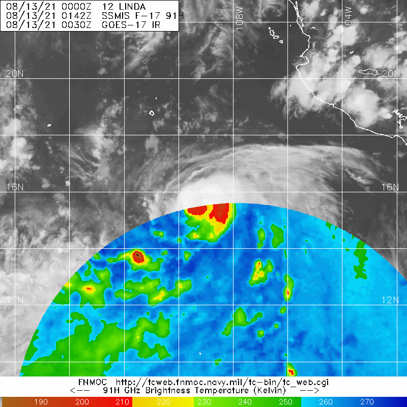
well-defined eye. A SSMIS 2348 UTC microwave pass also indicated a
closed mid-level eyewall had developed on the 91 GHz channel, though
the 37 GHz channel still suggested the low-level eyewall may still
be open to the west. Objective satellite estimates this evening
have been steadily increasing with the latest UW-CIMSS ADT estimate
up to T4.6/80 kt and the most recent SATCON estimate up to 76 kt.
However, subjective Dvorak estimates from SAB and TAFB were lower.
Given the improvement in Linda's structure this evening, the
intensity is raised to 75-kt for this advisory.
Linda continues to move to the west-northwest, with a slightly
faster forward motion at 300/11 kt. Linda should continue a general
west-northwest motion for the next several days as a mid-level ridge
remains parked over Mexico and the southwestern United States. After
48 hours, this ridge is forecast to build westward and become
reoriented west-southwest to east-northeast ahead of Linda. This
synoptic evolution should result in Linda turning to the west or
even west-southwest after 72 hours through the end of the forecast
period. The latest NHC track forecast is very similar to the
previous forecast for the first 48-72 hours, but has been shifted a
little further south thereafter. However, this forecast track is
still poleward of the GFS, ECMWF, and reliable HCCA consensus
guidance, and further southward adjustments may be needed in
subsequent forecasts.
Northerly vertical wind shear, which has slowed Linda's
intensification rate over the last day or so, appears to be slowly
subsiding, and the ECMWF-SHIPS guidance suggests this shear will
gradually decrease to under 10 kt by 48 hours. During this period,
Linda should remain in a moist environment and over 27-28 C
sea-surface temperatures. These factors favor strengthening, and the
improvement in Linda's inner-core structure argues for a faster rate
of intensification over the next 12-24 hours. The latest intensity
forecast was raised in the short-term, following the latest HCCA
guidance, and calls for a peak intensity of 95 kt in 36-48 hours. It
remains possible Linda could intensify a bit more than expected, as
the latest HWRF, HMON, and COAMPS-TC regional hurricane models
still show a peak intensity as a major hurricane. After 48 hours,
Linda will be moving over sub 27 C sea-surface temperatures and into
a drier environment, which should result in gradual weakening
through the end of the forecast period.
FORECAST POSITIONS AND MAX WINDS
INIT 13/0300Z 15.8N 109.6W 75 KT 85 MPH
12H 13/1200Z 16.6N 111.2W 85 KT 100 MPH
24H 14/0000Z 17.6N 113.5W 90 KT 105 MPH
36H 14/1200Z 18.5N 115.8W 95 KT 110 MPH
48H 15/0000Z 18.9N 118.0W 95 KT 110 MPH
60H 15/1200Z 19.0N 120.0W 90 KT 105 MPH
72H 16/0000Z 18.9N 121.9W 80 KT 90 MPH
96H 17/0000Z 18.3N 125.4W 65 KT 75 MPH
120H 18/0000Z 18.1N 129.4W 60 KT 70 MPH
$$
Forecaster Papin/Stewart
NWS National Hurricane Center Miami FL EP122021
900 PM MDT Thu Aug 12 2021
Linda is starting to intensify more in earnest. This evening, the
Central Dense Overcast has expanded some, especially to the
northwest which had previously been more restricted by moderate
northerly shear. A warm spot has been intermittently appearing on
infrared satellite imagery, suggesting the development of a more
well-defined eye. A SSMIS 2348 UTC microwave pass also indicated a
closed mid-level eyewall had developed on the 91 GHz channel, though
the 37 GHz channel still suggested the low-level eyewall may still
be open to the west. Objective satellite estimates this evening
have been steadily increasing with the latest UW-CIMSS ADT estimate
up to T4.6/80 kt and the most recent SATCON estimate up to 76 kt.
However, subjective Dvorak estimates from SAB and TAFB were lower.
Given the improvement in Linda's structure this evening, the
intensity is raised to 75-kt for this advisory.
Linda continues to move to the west-northwest, with a slightly
faster forward motion at 300/11 kt. Linda should continue a general
west-northwest motion for the next several days as a mid-level ridge
remains parked over Mexico and the southwestern United States. After
48 hours, this ridge is forecast to build westward and become
reoriented west-southwest to east-northeast ahead of Linda. This
synoptic evolution should result in Linda turning to the west or
even west-southwest after 72 hours through the end of the forecast
period. The latest NHC track forecast is very similar to the
previous forecast for the first 48-72 hours, but has been shifted a
little further south thereafter. However, this forecast track is
still poleward of the GFS, ECMWF, and reliable HCCA consensus
guidance, and further southward adjustments may be needed in
subsequent forecasts.
Northerly vertical wind shear, which has slowed Linda's
intensification rate over the last day or so, appears to be slowly
subsiding, and the ECMWF-SHIPS guidance suggests this shear will
gradually decrease to under 10 kt by 48 hours. During this period,
Linda should remain in a moist environment and over 27-28 C
sea-surface temperatures. These factors favor strengthening, and the
improvement in Linda's inner-core structure argues for a faster rate
of intensification over the next 12-24 hours. The latest intensity
forecast was raised in the short-term, following the latest HCCA
guidance, and calls for a peak intensity of 95 kt in 36-48 hours. It
remains possible Linda could intensify a bit more than expected, as
the latest HWRF, HMON, and COAMPS-TC regional hurricane models
still show a peak intensity as a major hurricane. After 48 hours,
Linda will be moving over sub 27 C sea-surface temperatures and into
a drier environment, which should result in gradual weakening
through the end of the forecast period.
FORECAST POSITIONS AND MAX WINDS
INIT 13/0300Z 15.8N 109.6W 75 KT 85 MPH
12H 13/1200Z 16.6N 111.2W 85 KT 100 MPH
24H 14/0000Z 17.6N 113.5W 90 KT 105 MPH
36H 14/1200Z 18.5N 115.8W 95 KT 110 MPH
48H 15/0000Z 18.9N 118.0W 95 KT 110 MPH
60H 15/1200Z 19.0N 120.0W 90 KT 105 MPH
72H 16/0000Z 18.9N 121.9W 80 KT 90 MPH
96H 17/0000Z 18.3N 125.4W 65 KT 75 MPH
120H 18/0000Z 18.1N 129.4W 60 KT 70 MPH
$$
Forecaster Papin/Stewart
0 likes
Visit the Caribbean-Central America Weather Thread where you can find at first post web cams,radars
and observations from Caribbean basin members Click Here
and observations from Caribbean basin members Click Here
-
Yellow Evan
- Professional-Met
- Posts: 16240
- Age: 27
- Joined: Fri Jul 15, 2011 12:48 pm
- Location: Henderson, Nevada/Honolulu, HI
- Contact:
Re: EPAC: LINDA - Hurricane

Dry air seems to have gotten in on the NW side but CDO continues to expand otherwise.
0 likes
-
Sciencerocks
- Category 5
- Posts: 10186
- Age: 40
- Joined: Thu Jul 06, 2017 1:51 am

-
Kingarabian
- S2K Supporter
- Posts: 16367
- Joined: Sat Aug 08, 2009 3:06 am
- Location: Honolulu, Hawaii

-
Kingarabian
- S2K Supporter
- Posts: 16367
- Joined: Sat Aug 08, 2009 3:06 am
- Location: Honolulu, Hawaii
Re: EPAC: LINDA - Hurricane
Just for informative purposes and is mere speculation this far out, but looks like a couple of Hawaii hits on the 00z EPS and a good amount of close calls.
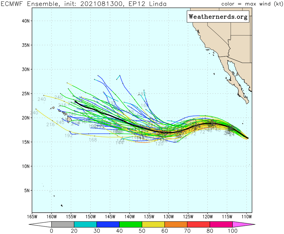
More than likely it'll get picked up just before the islands as these system that take this track typically do.
More than likely it'll get picked up just before the islands as these system that take this track typically do.
Last edited by Kingarabian on Fri Aug 13, 2021 4:18 am, edited 2 times in total.
0 likes
RIP Kobe Bryant
-
Kingarabian
- S2K Supporter
- Posts: 16367
- Joined: Sat Aug 08, 2009 3:06 am
- Location: Honolulu, Hawaii
Re: EPAC: LINDA - Hurricane
TXPZ23 KNES 130604
TCSENP
A. 12E (LINDA)
B. 13/0530Z
C. 16.0N
D. 110.0W
E. THREE/GOES-W
F. T4.0/4.0
G. IR/EIR/SWIR/SSMIS
H. REMARKS...6.5/10 WHITE BANDING AROUND LLCC YIELDS DT OF 3.5. MET
AND PT ARE 4.0 AND FT IS BASED ON MET DUE TO BANDING NOT BEING CLEAR-CUT.
I. ADDL POSITIONS
12/2348Z 15.5N 109.3W SSMIS
13/0142Z 15.7N 109.5W SSMIS
...MLEVINE
0 likes
RIP Kobe Bryant
-
Kingarabian
- S2K Supporter
- Posts: 16367
- Joined: Sat Aug 08, 2009 3:06 am
- Location: Honolulu, Hawaii
Re: EPAC: LINDA - Hurricane
It's show time:

Could say its worthy of a 5.5 but winds need time to catch up so it's not at major hurricane strength yet.
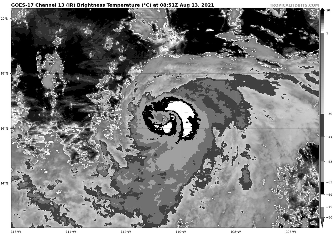
Could say its worthy of a 5.5 but winds need time to catch up so it's not at major hurricane strength yet.
0 likes
RIP Kobe Bryant
-
cycloneye
- Admin
- Posts: 149514
- Age: 69
- Joined: Thu Oct 10, 2002 10:54 am
- Location: San Juan, Puerto Rico
Re: EPAC: LINDA - Hurricane
Hurricane Linda Discussion Number 13
NWS National Hurricane Center Miami FL EP122021
300 AM MDT Fri Aug 13 2021
Over the past couple of hours, satellite images show the convection
becoming more symmetrical around warming cloud tops over Linda's
center, indicating a better-defined eye may be forming. The latest
Dvorak intensity estimates ranged from 65 to 82 kt, and based on the
recent satellite trends, the higher end of these estimates are
favored for an initial intensity of 80 kt. A recent ASCAT overpass
was able to provide useful information regarding the cyclone's wind
radii, with winds of tropical storm force extending up to 150 n mi
to the south of its center.
Given the improving structure of the cyclone, Linda is expected to
strengthen quickly over the next day or so, while the system is
forecast to remain in an environment of decreasing vertical wind
shear and over warm waters. By 48 h, decreasing SSTs and
increasingly unfavorable thermodynamic conditions should cause the
cyclone to begin weakening. The latest NHC intensity forecast is
little changed from the previous one, and lies between the IVCN
consensus and the HFIP corrected consensus HCCA.
Linda is moving toward the west-northwest at 11 kt along the
periphery of a mid-level ridge to its north and northeast. This
ridge is forecast to build westward with time, and eventually build
to the northwest of the cyclone as well, forcing it to the west in
a couple of days and then perhaps west-southwest later in the
forecast period. The track guidance is in very good agreement on
this scenario and only slight adjustments were made to the previous
NHC track forecast. This prediction lies near the various
consensus model tracks.
FORECAST POSITIONS AND MAX WINDS
INIT 13/0900Z 16.4N 110.6W 80 KT 90 MPH
12H 13/1800Z 17.1N 112.3W 90 KT 105 MPH
24H 14/0600Z 18.0N 114.7W 95 KT 110 MPH
36H 14/1800Z 18.6N 116.9W 95 KT 110 MPH
48H 15/0600Z 18.9N 119.1W 90 KT 105 MPH
60H 15/1800Z 18.8N 121.0W 85 KT 100 MPH
72H 16/0600Z 18.5N 123.1W 75 KT 85 MPH
96H 17/0600Z 17.9N 127.0W 65 KT 75 MPH
120H 18/0600Z 18.0N 131.0W 60 KT 70 MPH
$$
Forecaster Latto
1 likes
Visit the Caribbean-Central America Weather Thread where you can find at first post web cams,radars
and observations from Caribbean basin members Click Here
and observations from Caribbean basin members Click Here
-
Kingarabian
- S2K Supporter
- Posts: 16367
- Joined: Sat Aug 08, 2009 3:06 am
- Location: Honolulu, Hawaii
Re: EPAC: LINDA - Hurricane
cycloneye wrote:Hurricane Linda Discussion Number 13
NWS National Hurricane Center Miami FL EP122021
300 AM MDT Fri Aug 13 2021
Over the past couple of hours, satellite images show the convection
becoming more symmetrical around warming cloud tops over Linda's
center, indicating a better-defined eye may be forming. The latest
Dvorak intensity estimates ranged from 65 to 82 kt, and based on the
recent satellite trends, the higher end of these estimates are
favored for an initial intensity of 80 kt. A recent ASCAT overpass
was able to provide useful information regarding the cyclone's wind
radii, with winds of tropical storm force extending up to 150 n mi
to the south of its center.
Given the improving structure of the cyclone, Linda is expected to
strengthen quickly over the next day or so, while the system is
forecast to remain in an environment of decreasing vertical wind
shear and over warm waters. By 48 h, decreasing SSTs and
increasingly unfavorable thermodynamic conditions should cause the
cyclone to begin weakening. The latest NHC intensity forecast is
little changed from the previous one, and lies between the IVCN
consensus and the HFIP corrected consensus HCCA.
Linda is moving toward the west-northwest at 11 kt along the
periphery of a mid-level ridge to its north and northeast. This
ridge is forecast to build westward with time, and eventually build
to the northwest of the cyclone as well, forcing it to the west in
a couple of days and then perhaps west-southwest later in the
forecast period. The track guidance is in very good agreement on
this scenario and only slight adjustments were made to the previous
NHC track forecast. This prediction lies near the various
consensus model tracks.
FORECAST POSITIONS AND MAX WINDS
INIT 13/0900Z 16.4N 110.6W 80 KT 90 MPH
12H 13/1800Z 17.1N 112.3W 90 KT 105 MPH
24H 14/0600Z 18.0N 114.7W 95 KT 110 MPH
36H 14/1800Z 18.6N 116.9W 95 KT 110 MPH
48H 15/0600Z 18.9N 119.1W 90 KT 105 MPH
60H 15/1800Z 18.8N 121.0W 85 KT 100 MPH
72H 16/0600Z 18.5N 123.1W 75 KT 85 MPH
96H 17/0600Z 17.9N 127.0W 65 KT 75 MPH
120H 18/0600Z 18.0N 131.0W 60 KT 70 MPH
$$
Forecaster Latto
This is atleast 90kts lol.
0 likes
RIP Kobe Bryant
-
Yellow Evan
- Professional-Met
- Posts: 16240
- Age: 27
- Joined: Fri Jul 15, 2011 12:48 pm
- Location: Henderson, Nevada/Honolulu, HI
- Contact:
Re: EPAC: LINDA - Hurricane
Yeah this is bombing out. CDO needs to smoothen and eye needs to stabilize though.
0 likes
Who is online
Users browsing this forum: No registered users and 19 guests