ATL: GRACE - Models

Moderator: S2k Moderators

Message
Author
Carolinagirl18
Tropical Low
Tropical Low
Posts: 15
Joined: Wed Aug 14, 2019 6:47 pm

Re: ATL: 95L - Models

#161 Postby Carolinagirl18 » Fri Aug 13, 2021 6:14 am

OuterBanker wrote::eek: :eek: WOW :eek: :eek:

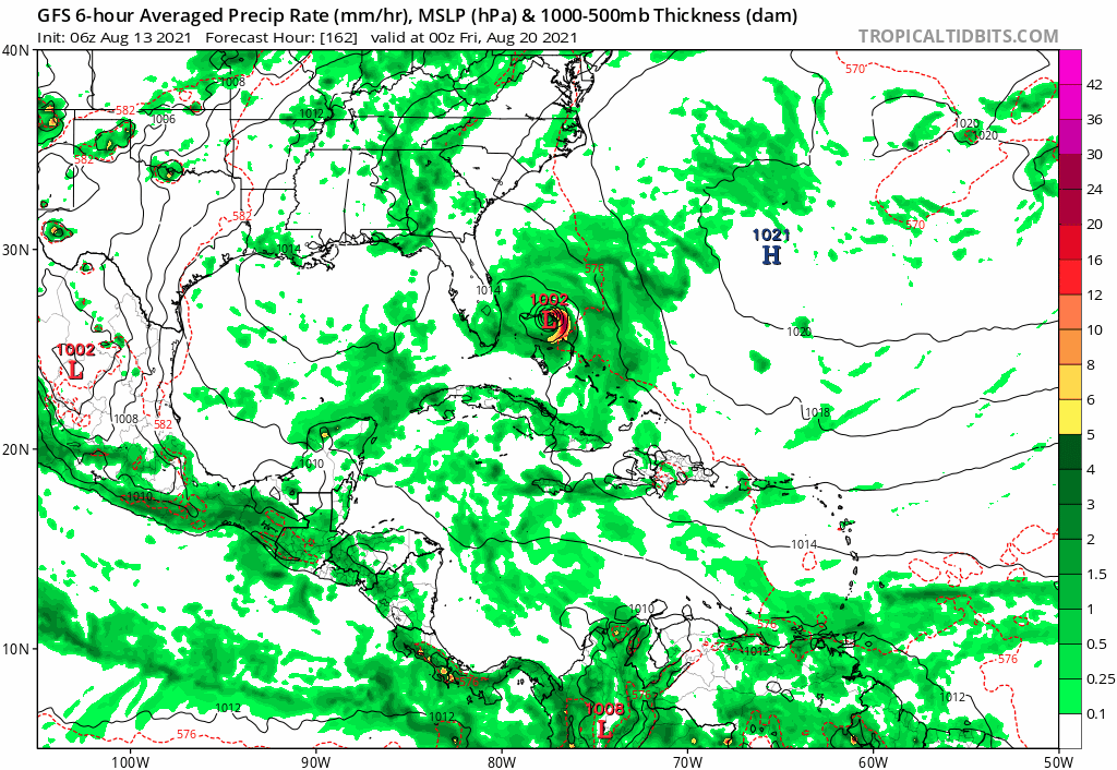
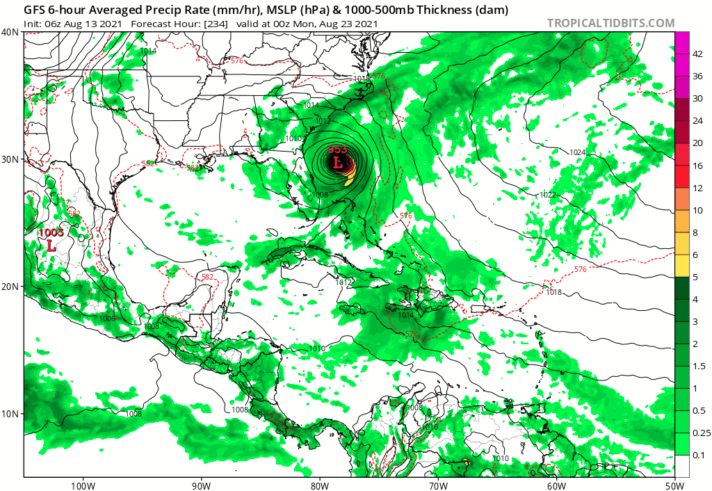
Ain't gonna happen but 0z GFS has a hurricane stall of FL then head north for a OBX direct hit bordering cat 4.

Pure fantasy of course.

Thats more like Carteret co for land fall. Not outer banks although they would get some of it. To far out to know yet but we've seen this track yo many times
0 likes   

User avatar
Hurricaneman
Category 5
Category 5
Posts: 7351
Age: 45
Joined: Tue Aug 31, 2004 3:24 pm
Location: central florida

Re: ATL: 95L - Models

#162 Postby Hurricaneman » Fri Aug 13, 2021 6:52 am

6zGFS is finally running
1 likes   

User avatar
SouthFLTropics
Category 5
Category 5
Posts: 4236
Age: 50
Joined: Thu Aug 14, 2003 8:04 am
Location: Port St. Lucie, Florida

Re: ATL: 95L - Models

#163 Postby SouthFLTropics » Fri Aug 13, 2021 7:04 am

06z GFS already looking ominous north of PR.


Sent from my iPhone using Tapatalk
0 likes   
Fourth Generation Florida Native

Personal Storm History: David 79, Andrew 92, Erin 95, Floyd 99, Irene 99, Frances 04, Jeanne 04, Wilma 05, Matthew 16, Irma 17, Ian 22, Nicole 22, Milton 24

User avatar
Hurricaneman
Category 5
Category 5
Posts: 7351
Age: 45
Joined: Tue Aug 31, 2004 3:24 pm
Location: central florida

Re: ATL: 95L - Models

#164 Postby Hurricaneman » Fri Aug 13, 2021 7:07 am

SouthFLTropics wrote:06z GFS already looking ominous north of PR.


Sent from my iPhone using Tapatalk


Not quite as strong at this point this run but a little SW of 0z
0 likes   

User avatar
Hypercane_Kyle
Category 5
Category 5
Posts: 3352
Joined: Sat Mar 07, 2015 7:58 pm
Location: Cape Canaveral, FL

Re: ATL: 95L - Models

#165 Postby Hypercane_Kyle » Fri Aug 13, 2021 7:13 am

06z GFS coming in considerably weaker through 132 hours.
1 likes   
My posts are my own personal opinion, defer to the National Hurricane Center (NHC) and other NOAA products for decision making during hurricane season.

Shell Mound
Category 5
Category 5
Posts: 2434
Age: 32
Joined: Thu Sep 07, 2017 3:39 pm
Location: St. Petersburg, FL → Scandinavia

Re: ATL: 95L - Models

#166 Postby Shell Mound » Fri Aug 13, 2021 7:13 am

Hurricaneman wrote:
SouthFLTropics wrote:06z GFS already looking ominous north of PR.


Sent from my iPhone using Tapatalk

Not quite as strong at this point this run but a little SW of 0z

On this run a strong TUTT descends just in time to decapitate the low as it approaches the easternmost Bahamas. The TUTT also accounts for the weaker intensity.
0 likes   
CVW / MiamiensisWx / Shell Mound
The posts in this forum are NOT official forecasts and should not be used as such. They are just the opinion of the poster and may or may not be backed by sound meteorological data. They are NOT endorsed by any professional institution or STORM2K. For official information, please refer to products from the NHC and NWS.

AutoPenalti
Category 5
Category 5
Posts: 4030
Age: 29
Joined: Mon Aug 17, 2015 4:16 pm
Location: Ft. Lauderdale, Florida

Re: ATL: 95L - Models

#167 Postby AutoPenalti » Fri Aug 13, 2021 7:15 am

Without looking at the run it sounds like conditions became less favorable in the GFS?
0 likes   
The posts in this forum are NOT official forecasts and should not be used as such. They are just the opinion of the poster and may or may not be backed by sound meteorological data. They are NOT endorsed by any professional institution or STORM2K. For official information, please refer to products from the NHC and NWS.


Model Runs Cheat Sheet:
GFS (5:30 AM/PM, 11:30 AM/PM)
HWRF, GFDL, UKMET, NAVGEM (6:30-8:00 AM/PM, 12:30-2:00 AM/PM)
ECMWF (1:45 AM/PM)

TCVN
is a weighted averaged

User avatar
Hurricaneman
Category 5
Category 5
Posts: 7351
Age: 45
Joined: Tue Aug 31, 2004 3:24 pm
Location: central florida

Re: ATL: 95L - Models

#168 Postby Hurricaneman » Fri Aug 13, 2021 7:17 am

The difference between this run and 0z is the TUTT is a little farther west on this run imparting shear until the central Bahamas instead of the TUTT being east like the 0z
0 likes   

User avatar
aspen
Category 5
Category 5
Posts: 8818
Joined: Sat Oct 12, 2019 7:10 pm
Location: Connecticut, USA

Re: ATL: 95L - Models

#169 Postby aspen » Fri Aug 13, 2021 7:26 am

The track from the last two GFS runs reminds me of a certain D storm from a few years ago…hopefully it turns away at the last moment without stalling.
0 likes   
Irene '11 Sandy '12 Hermine '16 5/15/2018 Derecho Fay '20 Isaias '20 Elsa '21 Henri '21 Ida '21

I am only a meteorology enthusiast who knows a decent amount about tropical cyclones. Look to the professional mets, the NHC, or your local weather office for the best information.

User avatar
SFLcane
S2K Supporter
S2K Supporter
Posts: 10163
Age: 47
Joined: Sat Jun 05, 2010 1:44 pm
Location: Lake Worth Florida

Re: ATL: 95L - Models

#170 Postby SFLcane » Fri Aug 13, 2021 7:30 am

Gfs trending westward from 00z run. Next run potentially into Florida.
0 likes   

Shell Mound
Category 5
Category 5
Posts: 2434
Age: 32
Joined: Thu Sep 07, 2017 3:39 pm
Location: St. Petersburg, FL → Scandinavia

Re: ATL: 95L - Models

#171 Postby Shell Mound » Fri Aug 13, 2021 7:38 am

aspen wrote:The track from the last two GFS runs reminds me of a certain D storm from a few years ago…hopefully it turns away at the last moment without stalling.

The 06Z GFS is basically Dorian 2.0: 95L rapidly deepens as it slows and stalls either over or just north of the Abaco Islands, becoming a major in the process.
1 likes   
CVW / MiamiensisWx / Shell Mound
The posts in this forum are NOT official forecasts and should not be used as such. They are just the opinion of the poster and may or may not be backed by sound meteorological data. They are NOT endorsed by any professional institution or STORM2K. For official information, please refer to products from the NHC and NWS.

User avatar
Kohlecane
Category 2
Category 2
Posts: 593
Age: 33
Joined: Sun Jul 31, 2011 11:03 pm
Location: Beaufort, SC

Re: ATL: 95L - Models

#172 Postby Kohlecane » Fri Aug 13, 2021 7:38 am

06Z GFS showing some consistency on getting this thing above the islands and close to the SE coast as a CAT 2/3 as of 228hr
0 likes   
Once I see the REDS and GREENS Converge on a Base Velocity. ... I'm There!!

This is NOT an Official Forecast....Just my Opinion. For official information, please refer to the NHC and NWS products.
HIGHLIGHTS : '13 El Reno Tornado : 2013 Storm Chaser Tour, Joaquin; SC flood event, Matthew '16, Lowcountry Snow storm Jan '18

User avatar
Hypercane_Kyle
Category 5
Category 5
Posts: 3352
Joined: Sat Mar 07, 2015 7:58 pm
Location: Cape Canaveral, FL

Re: ATL: 95L - Models

#173 Postby Hypercane_Kyle » Fri Aug 13, 2021 7:44 am

Hypercane_Kyle wrote:06z GFS coming in considerably weaker through 132 hours.


Results in a more western-trekking storm once it storms intensifying.
0 likes   
My posts are my own personal opinion, defer to the National Hurricane Center (NHC) and other NOAA products for decision making during hurricane season.

Shell Mound
Category 5
Category 5
Posts: 2434
Age: 32
Joined: Thu Sep 07, 2017 3:39 pm
Location: St. Petersburg, FL → Scandinavia

Re: ATL: 95L - Models

#174 Postby Shell Mound » Fri Aug 13, 2021 7:44 am

Shell Mound wrote:
aspen wrote:The track from the last two GFS runs reminds me of a certain D storm from a few years ago…hopefully it turns away at the last moment without stalling.

The 06Z GFS is basically Dorian 2.0: 95L rapidly deepens as it slows and stalls either over or just north of the Abaco Islands, becoming a major in the process.

The GFS is showing an extremely rare sight: an intensifying Category-4 cyclone heading NW into GA/SC, à la 1898, Gracie (1959), or Hugo (1989). Here is an image:

Image
1 likes   
CVW / MiamiensisWx / Shell Mound
The posts in this forum are NOT official forecasts and should not be used as such. They are just the opinion of the poster and may or may not be backed by sound meteorological data. They are NOT endorsed by any professional institution or STORM2K. For official information, please refer to products from the NHC and NWS.

BobHarlem
Category 5
Category 5
Posts: 2105
Joined: Thu Oct 20, 2005 6:11 pm

Re: ATL: 95L - Models

#175 Postby BobHarlem » Fri Aug 13, 2021 7:49 am

0z GFS Outer Banks, 6Z GFS Savannah GA Strong Cat 3
0 likes   

Shell Mound
Category 5
Category 5
Posts: 2434
Age: 32
Joined: Thu Sep 07, 2017 3:39 pm
Location: St. Petersburg, FL → Scandinavia

Re: ATL: 95L - Models

#176 Postby Shell Mound » Fri Aug 13, 2021 7:52 am

Shell Mound wrote:
Shell Mound wrote:
aspen wrote:The track from the last two GFS runs reminds me of a certain D storm from a few years ago…hopefully it turns away at the last moment without stalling.

The 06Z GFS is basically Dorian 2.0: 95L rapidly deepens as it slows and stalls either over or just north of the Abaco Islands, becoming a major in the process.

The GFS is showing an extremely rare sight: an intensifying Category-4 cyclone heading NW into GA/SC, à la 1898, Gracie (1959), or Hugo (1989). Here is an image:

https://i.ibb.co/pPm8Gzc/Georgia-1.png

Landfall occurs just north of Sapelo Island, GA, roughly between Darien and Savannah, around midnight EDT on 25 August, with some modest filling pre-landfall:

Image
0 likes   
CVW / MiamiensisWx / Shell Mound
The posts in this forum are NOT official forecasts and should not be used as such. They are just the opinion of the poster and may or may not be backed by sound meteorological data. They are NOT endorsed by any professional institution or STORM2K. For official information, please refer to products from the NHC and NWS.

User avatar
Hypercane_Kyle
Category 5
Category 5
Posts: 3352
Joined: Sat Mar 07, 2015 7:58 pm
Location: Cape Canaveral, FL

Re: ATL: 95L - Models

#177 Postby Hypercane_Kyle » Fri Aug 13, 2021 7:53 am

Image
1 likes   
My posts are my own personal opinion, defer to the National Hurricane Center (NHC) and other NOAA products for decision making during hurricane season.

Shell Mound
Category 5
Category 5
Posts: 2434
Age: 32
Joined: Thu Sep 07, 2017 3:39 pm
Location: St. Petersburg, FL → Scandinavia

Re: ATL: 95L - Models

#178 Postby Shell Mound » Fri Aug 13, 2021 8:13 am

Image
Image

Dorian 2.0: just a bit farther northwest this time...
0 likes   
CVW / MiamiensisWx / Shell Mound
The posts in this forum are NOT official forecasts and should not be used as such. They are just the opinion of the poster and may or may not be backed by sound meteorological data. They are NOT endorsed by any professional institution or STORM2K. For official information, please refer to products from the NHC and NWS.

User avatar
SFLcane
S2K Supporter
S2K Supporter
Posts: 10163
Age: 47
Joined: Sat Jun 05, 2010 1:44 pm
Location: Lake Worth Florida

Re: ATL: 95L - Models

#179 Postby SFLcane » Fri Aug 13, 2021 8:13 am

Image

Image
0 likes   

caneseddy
Category 5
Category 5
Posts: 1172
Joined: Fri Sep 03, 2004 9:31 pm
Location: Plantation, FL

Re: ATL: 95L - Models

#180 Postby caneseddy » Fri Aug 13, 2021 8:16 am

GFS trending SW the past two runs

00z was North Carolina
06z is GA/SC border

Will it continue the trend? Stay tuned!
0 likes   


Return to “2021”

Who is online

Users browsing this forum: No registered users and 2 guests