
EDIT: Dang 945mb into S TX.
Moderator: S2k Moderators


Category5Kaiju wrote:toad strangler wrote:Category5Kaiju wrote:Yikes, just looked at the most recent GEFS, and it shows a fairly strong ensemble support signal for a system to slam into the Rio Grande/Gulf of Mexico region between TX and Mexico shortly after the August 20th timeframe; some members take it further south while others further north, I seriously am thinking that the wave that just departed Africa is worthy of monitoring
You are talking about GFS end of the run type hours here so it's complete fantasy range to be mentioning an end game for a wave that is still shaking off zebras and lions. That wave is already being discussed and does seem to have potential.... at least I'm pretty sure you mean this one .... viewtopic.php?f=31&t=122069
I know things will likely change between now and then, but yeah that wave, it just exited Africa and looks quite robust with some nice spinnage already. I think it won't do much until it is closer to the islands, but I have a hunch that once it enters that region, we'll be monitoring it like a hawk.
SoupBone wrote:Category5Kaiju wrote:toad strangler wrote:
You are talking about GFS end of the run type hours here so it's complete fantasy range to be mentioning an end game for a wave that is still shaking off zebras and lions. That wave is already being discussed and does seem to have potential.... at least I'm pretty sure you mean this one .... viewtopic.php?f=31&t=122069
I know things will likely change between now and then, but yeah that wave, it just exited Africa and looks quite robust with some nice spinnage already. I think it won't do much until it is closer to the islands, but I have a hunch that once it enters that region, we'll be monitoring it like a hawk.
His point, which was a solid one, is that we're talking in complete fantasy land for that system at this point. Way too many variables for any area to be too concerned. But hey, it is peak season right?


aspen wrote:There's a bit of support for a potential subtropical system in a few days, while the ensembles are hinting there could eventually be another MDR system by mid-late next week or later.
ECENS ensembles:
https://i.imgur.com/hkfxR2x.png
https://i.imgur.com/2OoFg2H.png
Operational ECMWF:
https://i.imgur.com/uSBwafu.png
GEFS ensembles:
https://i.imgur.com/H841SrR.png
It's possible the subtropical system (could be Henri) will help weaken the ridge and help Grace come further north. Some CFS runs have supported the idea of a MDR storm (could be Ida) around the August 20th-25th timeframe.
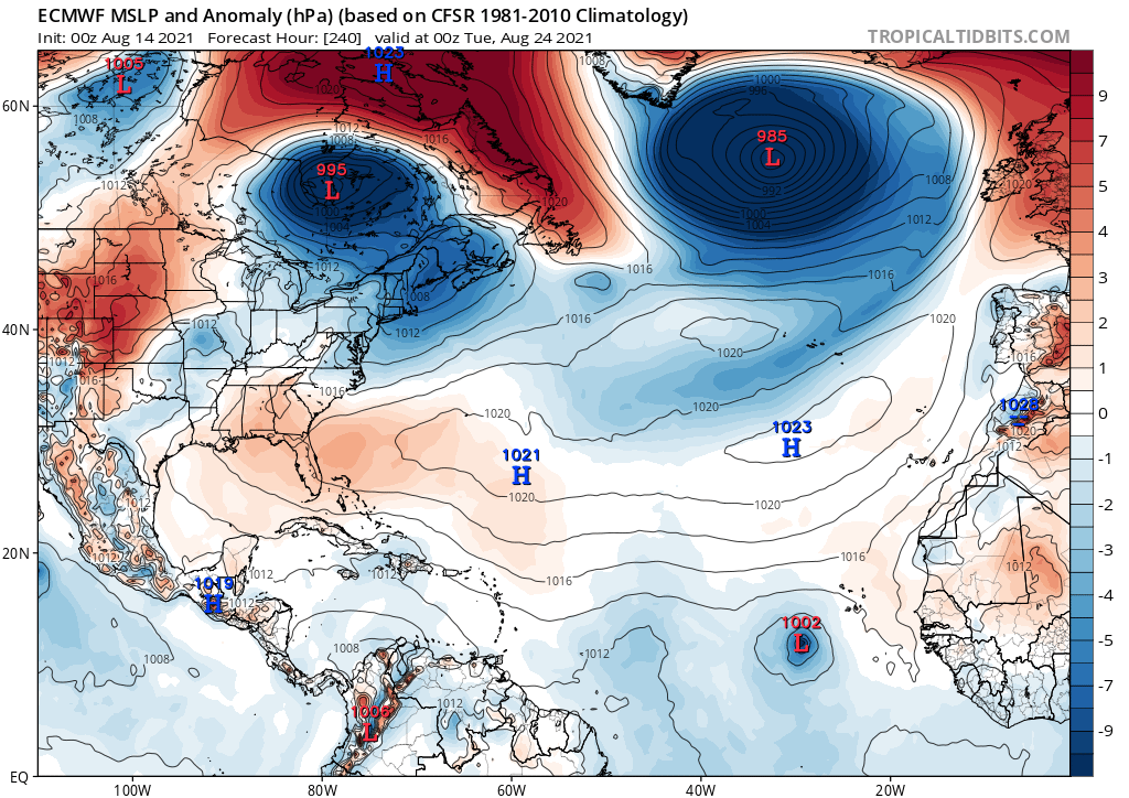

AlphaToOmega wrote:We could have Julian as early as August 24
https://i.postimg.cc/Dy4911ZX/ecmwf-mslpa-atl-11.png
AlphaToOmega wrote:We could have Julian as early as August 24
https://i.postimg.cc/Dy4911ZX/ecmwf-mslpa-atl-11.png
MetroMike wrote:AlphaToOmega wrote:We could have Julian as early as August 24
https://i.postimg.cc/Dy4911ZX/ecmwf-mslpa-atl-11.png
Waiting for the H and I storm before this lmao.


AlphaToOmega wrote:MetroMike wrote:AlphaToOmega wrote:We could have Julian as early as August 24
https://i.postimg.cc/Dy4911ZX/ecmwf-mslpa-atl-11.png
Waiting for the H and I storm before this lmao.
Henri could be the subtropical storm shown in ensemble runs over the Bahamas, and Ida could be the next wave after Grace.


crownweather wrote:captainbarbossa19 wrote:AlphaToOmega wrote:
Henri could be the subtropical storm shown in ensemble runs over the Bahamas, and Ida could be the next wave after Grace.
Plus the dreaded "I" storm.
If Grace fails to become our first major, I am thinking it will be Ida. If she is the next wave, she will be forming right around the 20th. The switch almost always seems to flip around that date. Usually, conditions do not really start to become super favorable until about the 25th-31st. We will see, but I suspect that we are going to get a major very soon.
crownweather wrote:crownweather wrote:captainbarbossa19 wrote:
Plus the dreaded "I" storm.
If Grace fails to become our first major, I am thinking it will be Ida. If she is the next wave, she will be forming right around the 20th. The switch almost always seems to flip around that date. Usually, conditions do not really start to become super favorable until about the 25th-31st. We will see, but I suspect that we are going to get a major very soon.
Plus the dreaded "I" storm.


Users browsing this forum: No registered users and 184 guests


