ATL: GRACE - Models

Moderator: S2k Moderators

Message
Author
Cat5James
Category 1
Category 1
Posts: 417
Joined: Fri Sep 06, 2019 7:54 pm

Re: ATL: GRACE - Models

#501 Postby Cat5James » Sat Aug 14, 2021 6:44 pm

Kohlecane wrote:Bahamas Bound for the HWRF, What was the last system that the HWRF did really well with ?

What was the last system any of these models have done will with? Seems like if it’s not a clear cut path with no terrain in the way and optimal atmospheric conditions these models are all over the place run to run.
4 likes   

AxaltaRacing24
Category 5
Category 5
Posts: 1753
Age: 24
Joined: Wed Jul 27, 2016 11:14 am
Location: Jupiter, FL

Re: ATL: GRACE - Models

#502 Postby AxaltaRacing24 » Sat Aug 14, 2021 6:47 pm

Kohlecane wrote:Bahamas Bound for the HWRF, What was the last system that the HWRF did really well with ?

We are going to find out very soon. Watch for when Grace passes PR. If it goes over it or north, it gives the HWRF credit. If it goes south of the Island, then a more south track would become a likely scenario.
0 likes   

HurricaneFrances04
Category 2
Category 2
Posts: 597
Joined: Mon Jun 25, 2012 8:09 am
Location: Fort Lauderdale, Florida

Re: ATL: GRACE - Models

#503 Postby HurricaneFrances04 » Sat Aug 14, 2021 6:47 pm

Image
1 likes   

User avatar
Category5Kaiju
Category 5
Category 5
Posts: 4051
Joined: Thu Dec 24, 2020 12:45 pm
Location: Seattle

Re: ATL: GRACE - Models

#504 Postby Category5Kaiju » Sat Aug 14, 2021 6:48 pm

Whoa. Code lemon now, and the model ensembles are now showing a possibility for Grace to dip southwest through the Caribbean Sea? What is going on :lol:
0 likes   
Unless explicitly stated, all info in my posts is based on my own opinions and observations. Tropical storms and hurricanes can be extremely dangerous. Do not think you can beat Mother Nature. Refer to an accredited weather research agency or meteorologist if you need to make serious decisions regarding an approaching storm.

User avatar
Nimbus
Category 5
Category 5
Posts: 5274
Joined: Mon Jul 19, 2004 10:54 am

Re: ATL: GRACE - Models

#505 Postby Nimbus » Sat Aug 14, 2021 6:49 pm

SouthFLTropics wrote:
HurricaneFrances04 wrote:Must be a complex setup. One gust of wind blows the wrong way and we get a completely different outcome. Kind of crazy the models can't figure it out only 48 hours out though.

Are we seeing a real time butterfly affect with the models? The notion that a butterfly can flap its wings and affect the weather. Not sure if there is truth the the theory in space/time but it’s about the best explanation that I can come up with. Chaos theory at its finest.


Sent from my iPhone using Tapatalk


Even if you believe in determinism for modeling storms the choice of data has to remove randomness from the evolution of the analysis. You would think the higher definition models would always do best but there are more branching errors with higher density data.
1 likes   

User avatar
SouthFLTropics
Category 5
Category 5
Posts: 4236
Age: 49
Joined: Thu Aug 14, 2003 8:04 am
Location: Port St. Lucie, Florida

Re: ATL: GRACE - Models

#506 Postby SouthFLTropics » Sat Aug 14, 2021 6:51 pm

Nimbus wrote:
SouthFLTropics wrote:
HurricaneFrances04 wrote:Must be a complex setup. One gust of wind blows the wrong way and we get a completely different outcome. Kind of crazy the models can't figure it out only 48 hours out though.

Are we seeing a real time butterfly affect with the models? The notion that a butterfly can flap its wings and affect the weather. Not sure if there is truth the the theory in space/time but it’s about the best explanation that I can come up with. Chaos theory at its finest.


Sent from my iPhone using Tapatalk


Even if you believe in determinism for modeling storms the choice of data has to remove randomness from the evolution of the analysis. You would think the higher definition models would always do best but there are more branching errors with higher density data.

Why did I just read this post in Jeff Goldblum’s voice? Dr. Malcolm anyone???


Sent from my iPhone using Tapatalk
1 likes   
Fourth Generation Florida Native

Personal Storm History: David 79, Andrew 92, Erin 95, Floyd 99, Irene 99, Frances 04, Jeanne 04, Wilma 05, Matthew 16, Irma 17, Ian 22, Nicole 22, Milton 24

User avatar
Blown Away
S2K Supporter
S2K Supporter
Posts: 10140
Joined: Wed May 26, 2004 6:17 am

Re: ATL: GRACE - Models

#507 Postby Blown Away » Sat Aug 14, 2021 6:55 pm

Image
18z HWRF 96 Hours... @3.5 degrees N & @5 degrees E of 12z... Much, much slower... 96 hours appears to find better conditions??
Last edited by Blown Away on Sat Aug 14, 2021 6:56 pm, edited 1 time in total.
0 likes   
Hurricane Eye Experience: David 79, Irene 99, Frances 04, Jeanne 04, Wilma 05... EYE COMING MY WAY IN 2024…
Hurricane Brush Experience: Andrew 92, Erin 95, Floyd 99, Matthew 16, Irma 17, Ian 22, Nicole 22…

User avatar
Woofde
Category 1
Category 1
Posts: 475
Joined: Tue Jul 06, 2021 11:33 am

Re: ATL: GRACE - Models

#508 Postby Woofde » Sat Aug 14, 2021 6:56 pm

Looks like another "wait and see" storm. Models are all over the place again with no consistency what so ever. Deja vu.
0 likes   

jlauderdal
S2K Supporter
S2K Supporter
Posts: 7177
Joined: Wed May 19, 2004 5:46 am
Location: NE Fort Lauderdale
Contact:

Re: RE: Re: ATL: GRACE - Models

#509 Postby jlauderdal » Sat Aug 14, 2021 6:58 pm

Kohlecane wrote:Bahamas Bound for the HWRF, What was the last system that the HWRF did really well with ?
It did a great job with katrina on the approach to se florida, that was a few presidents ago
2 likes   

AxaltaRacing24
Category 5
Category 5
Posts: 1753
Age: 24
Joined: Wed Jul 27, 2016 11:14 am
Location: Jupiter, FL

Re: ATL: GRACE - Models

#510 Postby AxaltaRacing24 » Sat Aug 14, 2021 7:02 pm

Image

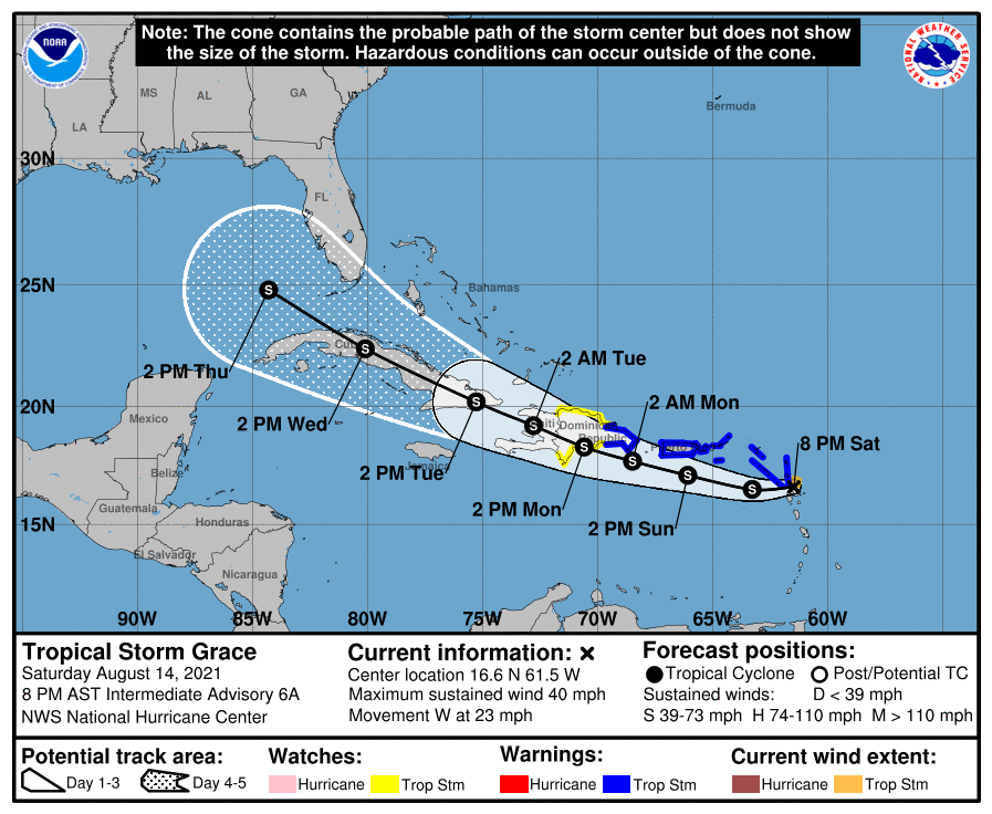
The NHC just confirmed what we have been seeing.
0 likes   

Deshaunrob17
Tropical Storm
Tropical Storm
Posts: 207
Joined: Tue Aug 18, 2020 7:49 am

Re: ATL: GRACE - Models

#511 Postby Deshaunrob17 » Sat Aug 14, 2021 7:08 pm

Neither of the two hurricane models are initializing Grace properly. The HMON pressure is off. The HWRF satellite is off- Grace has a lot of feeder band activity extending into the Southern WiNdwards.
Although, the HWRF started with the right pressure.
0 likes   

AutoPenalti
Category 5
Category 5
Posts: 4029
Age: 28
Joined: Mon Aug 17, 2015 4:16 pm
Location: Ft. Lauderdale, Florida

Re: ATL: GRACE - Models

#512 Postby AutoPenalti » Sat Aug 14, 2021 7:08 pm

That HWRF run is a little bit weird, it slows down almost immediately and heads NW before PR.
0 likes   
The posts in this forum are NOT official forecasts and should not be used as such. They are just the opinion of the poster and may or may not be backed by sound meteorological data. They are NOT endorsed by any professional institution or STORM2K. For official information, please refer to products from the NHC and NWS.


Model Runs Cheat Sheet:
GFS (5:30 AM/PM, 11:30 AM/PM)
HWRF, GFDL, UKMET, NAVGEM (6:30-8:00 AM/PM, 12:30-2:00 AM/PM)
ECMWF (1:45 AM/PM)

TCVN
is a weighted averaged

User avatar
SouthFLTropics
Category 5
Category 5
Posts: 4236
Age: 49
Joined: Thu Aug 14, 2003 8:04 am
Location: Port St. Lucie, Florida

Re: ATL: GRACE - Models

#513 Postby SouthFLTropics » Sat Aug 14, 2021 7:10 pm

The NHC 8pm position is well north of the 5pm position for a storm that is moving 270 at 23MPH. I think we’re getting a center relocation on approach to PR.


Sent from my iPhone using Tapatalk
1 likes   
Fourth Generation Florida Native

Personal Storm History: David 79, Andrew 92, Erin 95, Floyd 99, Irene 99, Frances 04, Jeanne 04, Wilma 05, Matthew 16, Irma 17, Ian 22, Nicole 22, Milton 24

User avatar
aspen
Category 5
Category 5
Posts: 8812
Joined: Sat Oct 12, 2019 7:10 pm
Location: Connecticut, USA

Re: ATL: GRACE - Models

#514 Postby aspen » Sat Aug 14, 2021 7:13 pm

SouthFLTropics wrote:The NHC 8pm position is well north of the 5pm position for a storm that is moving 270 at 23MPH. I think we’re getting a center relocation on approach to PR.


Sent from my iPhone using Tapatalk

I don’t think the center was ever that far south. Recon never bothered to check the main convective mass, so they went with what they thought was the main center, leading to all the tracks and models shifting south. We’ll need to wait until recon tomorrow determined the precise location of the LLC for any model to matter.
4 likes   
Irene '11 Sandy '12 Hermine '16 5/15/2018 Derecho Fay '20 Isaias '20 Elsa '21 Henri '21 Ida '21

I am only a meteorology enthusiast who knows a decent amount about tropical cyclones. Look to the professional mets, the NHC, or your local weather office for the best information.

User avatar
SouthFLTropics
Category 5
Category 5
Posts: 4236
Age: 49
Joined: Thu Aug 14, 2003 8:04 am
Location: Port St. Lucie, Florida

Re: ATL: GRACE - Models

#515 Postby SouthFLTropics » Sat Aug 14, 2021 7:15 pm

HWRF about to lay the smack down to Key Largo…976mb and deepening.


Sent from my iPhone using Tapatalk
0 likes   
Fourth Generation Florida Native

Personal Storm History: David 79, Andrew 92, Erin 95, Floyd 99, Irene 99, Frances 04, Jeanne 04, Wilma 05, Matthew 16, Irma 17, Ian 22, Nicole 22, Milton 24

User avatar
Kohlecane
Category 2
Category 2
Posts: 591
Age: 33
Joined: Sun Jul 31, 2011 11:03 pm
Location: Beaufort, SC

Re: ATL: GRACE - Models

#516 Postby Kohlecane » Sat Aug 14, 2021 7:18 pm

HWRF hits wall at 117h and goes West :double:
0 likes   
Once I see the REDS and GREENS Converge on a Base Velocity. ... I'm There!!

This is NOT an Official Forecast....Just my Opinion. For official information, please refer to the NHC and NWS products.
HIGHLIGHTS : '13 El Reno Tornado : 2013 Storm Chaser Tour, Joaquin; SC flood event, Matthew '16, Lowcountry Snow storm Jan '18

User avatar
Blown Away
S2K Supporter
S2K Supporter
Posts: 10140
Joined: Wed May 26, 2004 6:17 am

Re: ATL: GRACE - Models

#517 Postby Blown Away » Sat Aug 14, 2021 7:21 pm

Image
18z HWRF... Big shift N with Cat 2 @105 mph hurricane into Upper Keys...
0 likes   
Hurricane Eye Experience: David 79, Irene 99, Frances 04, Jeanne 04, Wilma 05... EYE COMING MY WAY IN 2024…
Hurricane Brush Experience: Andrew 92, Erin 95, Floyd 99, Matthew 16, Irma 17, Ian 22, Nicole 22…

User avatar
Kohlecane
Category 2
Category 2
Posts: 591
Age: 33
Joined: Sun Jul 31, 2011 11:03 pm
Location: Beaufort, SC

Re: ATL: GRACE - Models

#518 Postby Kohlecane » Sat Aug 14, 2021 7:27 pm

Blown Away wrote:https://i.imgur.com/fOD5epI.gif
18z HWRF... Big shift N with Cat 2 @105 mph hurricane into Upper Keys...

Could only imagine what we would be looking at if this run went another 48 hours :eek:
0 likes   
Once I see the REDS and GREENS Converge on a Base Velocity. ... I'm There!!

This is NOT an Official Forecast....Just my Opinion. For official information, please refer to the NHC and NWS products.
HIGHLIGHTS : '13 El Reno Tornado : 2013 Storm Chaser Tour, Joaquin; SC flood event, Matthew '16, Lowcountry Snow storm Jan '18

tolakram
Admin
Admin
Posts: 19990
Age: 61
Joined: Sun Aug 27, 2006 8:23 pm
Location: Florence, KY (name is Mark)

Re: ATL: GRACE - Models

#519 Postby tolakram » Sat Aug 14, 2021 7:32 pm

18Z Euro
Image
0 likes   
M a r k
- - - - -
Join us in chat: Storm2K Chatroom Invite. Android and IOS apps also available.

The posts in this forum are NOT official forecasts and should not be used as such. Posts are NOT endorsed by any professional institution or STORM2K.org. For official information and forecasts, please refer to NHC and NWS products.

User avatar
Spacecoast
Category 2
Category 2
Posts: 758
Joined: Thu Aug 31, 2017 2:03 pm

Re: ATL: GRACE - Models

#520 Postby Spacecoast » Sat Aug 14, 2021 7:34 pm

Kohlecane wrote:
Blown Away wrote:https://i.imgur.com/fOD5epI.gif
18z HWRF... Big shift N with Cat 2 @105 mph hurricane into Upper Keys...

Could only imagine what we would be looking at if this run went another 48 hours :eek:


HWRF looks remarkably similar to 12z CMC run,which ends up N gulf (Alabama / Mississippi)

Aside from a couple of 12z EMCF ensemble members, the 12z CMC, and 18z HWRF are currently the northernmost tracks.
0 likes   


Return to “2021”

Who is online

Users browsing this forum: No registered users and 35 guests