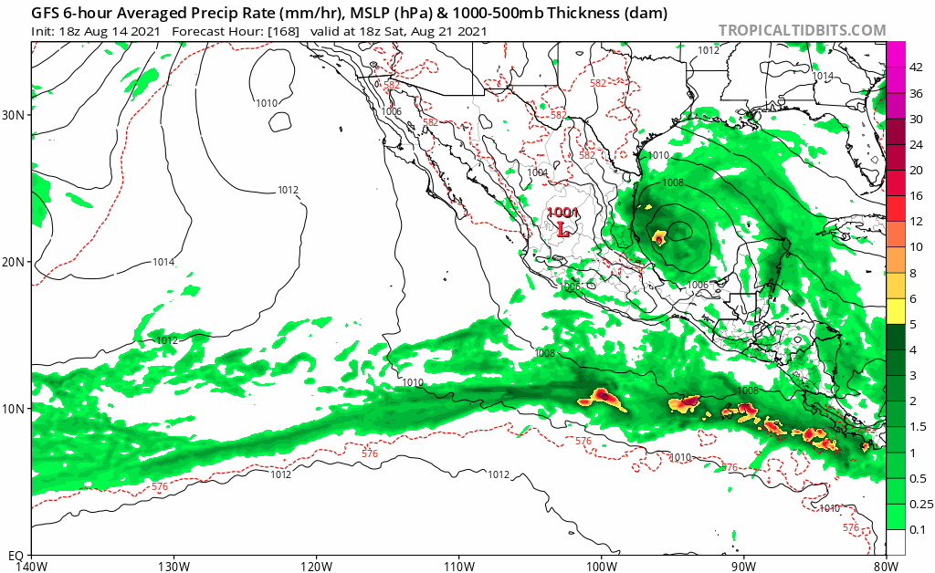
2021 Indicators: SST's / SAL / MSLP / Shear / Steering / Instability / Sat Images

This is the general tropical discussion area. Anyone can take their shot at predicting a storms path.

Moderator: S2k Moderators

Forum rules

The posts in this forum are NOT official forecasts and should not be used as such. They are just the opinion of the poster and may or may not be backed by sound meteorological data. They are NOT endorsed by any professional institution or STORM2K. For official information, please refer to products from the National Hurricane Center and National Weather Service.

Help Support Storm2K
Message
Author
User avatar
Category5Kaiju
Category 5
Category 5
Posts: 4097
Joined: Thu Dec 24, 2020 12:45 pm
Location: Seattle

Re: 2021 Indicators: SST's / SAL / MSLP / Shear / Steering / Instability / Sat Images

#2521 Postby Category5Kaiju » Sun Aug 15, 2021 1:44 pm

Deshaunrob17 wrote:
AlphaToOmega wrote:
gatorcane wrote:The GFS is trying to get the EPAC going again in the long-range, should it get active again, could keep a lid on the Atlantic.

https://i.postimg.cc/SN5YCyHs/gfs-mslp-pcpn-epac-fh168-384.gif


The GFS has been overestimating the EPac this year.


Even though the GfS has been overestimating the intensity of EPAC systems, we have to admit that the EPAC been much busier than many anticipated. Many doubted the GfS on the quantity of EPAC systems, but the GfS was not that far off because it’s been non stop activity in the EPAC..


Interestingly enough, the GFS did ok with predicting Linda to be a powerful hurricane (although the same cannot be said for Kevin or Hilda). I think what we are seeing is simply a very front loaded EPAC season, in fact, in 2017 we had a Cat 4 hurricane (Kenneth) right about the same time as Linda this year. I cannot imagine how in a -ENSO, -PMM, and -PDO state the EPAC would continue to overperform and shut down the Atlantic. If anything, quantity has been impressive, but aside from Linda and Felicia, most of the storms have been weak and sloppy (sort of like a 2007 Atlantic-like setup except in the EPAC where a handful of storms were very strong but the rest were very weak, with none exceeding Cat 1 in strength). I personally do not see anything strange with this pattern.
1 likes   
Unless explicitly stated, all info in my posts is based on my own opinions and observations. Tropical storms and hurricanes can be extremely dangerous. Do not think you can beat Mother Nature. Refer to an accredited weather research agency or meteorologist if you need to make serious decisions regarding an approaching storm.

User avatar
toad strangler
S2K Supporter
S2K Supporter
Posts: 4543
Joined: Sun Jul 28, 2013 3:09 pm
Location: Earth
Contact:

Re: 2021 Indicators: SST's / SAL / MSLP / Shear / Steering / Instability / Sat Images

#2522 Postby toad strangler » Sun Aug 15, 2021 2:00 pm

Category5Kaiju wrote:https://twitter.com/BMcNoldy/status/1426465678790365186

Very interesting tweet from Brian McNoldy a few days ago. Yes, Fred and Grace are struggling, but we nevertheless reached our 7th named storm even before hitting the August 15 mark and have a very real contender for the 8th named storm from 96L very soon (with this pace of NS formation only exceeded by 4 seasons, all of which were extremely active and impactful). Something tells me that after August 20, we won't be looking at this season the same way we are now, and the idea of slop storms, "2013 repeat," and all of these things are going to become a relic of the past. :(


Bell don't ring for 5 more days.
4 likes   

AxaltaRacing24
Category 5
Category 5
Posts: 1753
Age: 25
Joined: Wed Jul 27, 2016 11:14 am
Location: Jupiter, FL

Re: 2021 Indicators: SST's / SAL / MSLP / Shear / Steering / Instability / Sat Images

#2523 Postby AxaltaRacing24 » Sun Aug 15, 2021 2:10 pm

If you want to see what mid August usually looks like, view last year’s storms. One lasted a day, and the other dissipated before the islands. Not extremely long after that, Laura hit as a 150mph storm after the 8/20 date had passed. In 2017, Harvey died in the caribbean graveyard, and this was in late august. It soon came back, and hit as a category 4.

Fast forward to this year, and it’s more of the same for this time of the year. However, there are signs of the tide beginning to turn, and it won’t be long before quality systems begin to form.
6 likes   

User avatar
Category5Kaiju
Category 5
Category 5
Posts: 4097
Joined: Thu Dec 24, 2020 12:45 pm
Location: Seattle

Re: 2021 Indicators: SST's / SAL / MSLP / Shear / Steering / Instability / Sat Images

#2524 Postby Category5Kaiju » Sun Aug 15, 2021 2:13 pm

WiscoWx02 wrote:
Teban54 wrote:Watching Fred and Grace largely struggling (for now) around the GA really shows how anomalous Elsa was, and how conducive the base state was that allowed a hurricane moving at almost 30mph to exist in early July.

I still think the basin will eventually return to those favorable conditions soon. Some people keep saying the flip is being delayed, but that might end up being worse because that will collide perfectly with the climatological peak season.


That's something that I have been scratching my head with too. It's truly crazy to think that conditions were more favorable in the Atlantic in early July than they are now in a way. Now the Atlantic is just full of shear from TUTT's, an overly aggressive AEJ imparting easterly shear across the MDR, dry air and struggling storms. Nothing really new as it's not past August 20th yet, and I remember 2018 very well, so it is still too early to even think about writing off this season. Odds favor a ramp up this week or next week more than anything probably because of both climatology and the MJO being in a favorable state. However, on the off chance we are still in the same position 2-3 weeks from now, then I'm gonna start questioning if an active season is truly going to take place for obvious reasons.


If something like that does actually happen, then 2021 is going to need to be extensively studied as a reference for predicting future hurricane seasons, and we may need to slightly modify the way we predict hurricane season activity with seasonal factors like ENSO or sst anomalies (as such are clearly not the only major role-players in dictating seasonal activity). Looking at -ENSO and the marginal activity in the WPAC and EPAC, it looks to be setting up for a very favorable pattern for the Atlantic shear-wise. Sst anomalies are not insane, but they are high enough to support above average activity imho. We have not had significant SAL outbreaks, especially unlike last year. I personally think we are in a much better spot than 2013 (where we had waves that simply dried up in the MDR), and judging at the rate we are getting NSs as well as the idea that we already had an early July MDR hurricane, getting a season that underperforms would most definitely boggle my mind, perhaps even moreso than 2013.
3 likes   
Unless explicitly stated, all info in my posts is based on my own opinions and observations. Tropical storms and hurricanes can be extremely dangerous. Do not think you can beat Mother Nature. Refer to an accredited weather research agency or meteorologist if you need to make serious decisions regarding an approaching storm.

User avatar
weeniepatrol
Category 5
Category 5
Posts: 1273
Joined: Sat Aug 22, 2020 5:30 pm
Location: WA State

Re: 2021 Indicators: SST's / SAL / MSLP / Shear / Steering / Instability / Sat Images

#2525 Postby weeniepatrol » Sun Aug 15, 2021 2:17 pm

psyclone wrote:It's ok to start getting antsy now. We're entitled to some meat and potatoes.


No. Bell has not rung yet. We're entitled to nothing and all activity thus far has been red meat.

Frankly, I feel like I'm having an aneurysm reading people complain about shear and TUTTs. Anomalously low shear arrived in mid June and has generally persisted since. It's August 15th. Not September 15th

Image
11 likes   

User avatar
toad strangler
S2K Supporter
S2K Supporter
Posts: 4543
Joined: Sun Jul 28, 2013 3:09 pm
Location: Earth
Contact:

Re: 2021 Indicators: SST's / SAL / MSLP / Shear / Steering / Instability / Sat Images

#2526 Postby toad strangler » Sun Aug 15, 2021 2:35 pm

Mark Sudduth just said in layman's terms enjoy your above average albeit weak activity today, the real McCoy is coming.
9 likes   

User avatar
Steve
S2K Supporter
S2K Supporter
Posts: 9621
Joined: Sat Apr 05, 2003 11:41 pm
Location: Not a state-caster

Re: 2021 Indicators: SST's / SAL / MSLP / Shear / Steering / Instability / Sat Images

#2527 Postby Steve » Sun Aug 15, 2021 3:18 pm

I’m not saying I agree with the GFS, but you could see the EPAC have a little run before the next Atlantic burst. Follow the MJO after it rolls through Phase 3 end of next week or so (assuming it does per 6-varial combined forecast) - what happens next. You would think EPAC should be unfavorable for a couple weeks but probably come back to life first.

Also if the 6-comp MJO consensus is right that we are in Phase 3 end of the week which coincides with Grace coming up, will she maybe have the potential to overperform?
0 likes   

User avatar
Category5Kaiju
Category 5
Category 5
Posts: 4097
Joined: Thu Dec 24, 2020 12:45 pm
Location: Seattle

Re: 2021 Indicators: SST's / SAL / MSLP / Shear / Steering / Instability / Sat Images

#2528 Postby Category5Kaiju » Sun Aug 15, 2021 5:37 pm

Interesting thing to note: when Fred makes landfall, it would be the fourth TC to make landfall in the CONUS this season. Something tells me that the ridging setup this year is going to really heighten direct impacts for the CONUS like last year in a sense; while I am not expecting 11 or 12 NSs to hit the CONUS like last year, I think after this season is over there will be a decent list of direct landfalling storms for the CONUS. I hope I am wrong though.
0 likes   
Unless explicitly stated, all info in my posts is based on my own opinions and observations. Tropical storms and hurricanes can be extremely dangerous. Do not think you can beat Mother Nature. Refer to an accredited weather research agency or meteorologist if you need to make serious decisions regarding an approaching storm.

User avatar
SFLcane
S2K Supporter
S2K Supporter
Posts: 10163
Age: 47
Joined: Sat Jun 05, 2010 1:44 pm
Location: Lake Worth Florida

Re: 2021 Indicators: SST's / SAL / MSLP / Shear / Steering / Instability / Sat Images

#2529 Postby SFLcane » Sun Aug 15, 2021 6:03 pm

I don’t know about you guys but I am ready to get this season rolling and track some REAL hurricanes. I was just thinking to myself right now that we wouldn't have a hurricane yet without those 30 kt trade winds in Elsa. :roll:

Let’s get it!
10 likes   

AxaltaRacing24
Category 5
Category 5
Posts: 1753
Age: 25
Joined: Wed Jul 27, 2016 11:14 am
Location: Jupiter, FL

Re: 2021 Indicators: SST's / SAL / MSLP / Shear / Steering / Instability / Sat Images

#2530 Postby AxaltaRacing24 » Sun Aug 15, 2021 8:02 pm

SFLcane wrote:I don’t know about you guys but I am ready to get this season rolling and track some REAL hurricanes. I was just thinking to myself right now that we wouldn't have a hurricane yet without those 30 kt trade winds in Elsa. :roll:

Let’s get it!

All 3 storms out there currently have at least a small chance at hurricane status. Fred might, who knows with Grace, and Henri could.
0 likes   

User avatar
aspen
Category 5
Category 5
Posts: 8818
Joined: Sat Oct 12, 2019 7:10 pm
Location: Connecticut, USA

Re: 2021 Indicators: SST's / SAL / MSLP / Shear / Steering / Instability / Sat Images

#2531 Postby aspen » Sun Aug 15, 2021 8:10 pm

Despite the very strange fixation TCs this year have for getting ripped up in the Caribbean, it seems like we’ll have three TS strength systems active tomorrow: Fred, Grace (likely to be upgraded soon), and Henri (should be TD8 at 11pm). Rather impressive for mid-August.
4 likes   
Irene '11 Sandy '12 Hermine '16 5/15/2018 Derecho Fay '20 Isaias '20 Elsa '21 Henri '21 Ida '21

I am only a meteorology enthusiast who knows a decent amount about tropical cyclones. Look to the professional mets, the NHC, or your local weather office for the best information.

User avatar
Hammy
Category 5
Category 5
Posts: 5849
Age: 41
Joined: Fri May 25, 2012 5:25 pm
Contact:

Re: 2021 Indicators: SST's / SAL / MSLP / Shear / Steering / Instability / Sat Images

#2532 Postby Hammy » Sun Aug 15, 2021 10:58 pm

Getting 2011 vibes for this season, lots of weaker storms running through the name list in the run-up to late August.
5 likes   
The above post is not official and should not be used as such. It is the opinion of the poster and may or may not be backed by sound meteorological data. It is not endorsed by any professional institution or storm2k.org. For official information, please refer to the NHC and NWS products.

User avatar
Steve
S2K Supporter
S2K Supporter
Posts: 9621
Joined: Sat Apr 05, 2003 11:41 pm
Location: Not a state-caster

Re: 2021 Indicators: SST's / SAL / MSLP / Shear / Steering / Instability / Sat Images

#2533 Postby Steve » Sun Aug 15, 2021 11:24 pm

AxaltaRacing24 wrote:
SFLcane wrote:I don’t know about you guys but I am ready to get this season rolling and track some REAL hurricanes. I was just thinking to myself right now that we wouldn't have a hurricane yet without those 30 kt trade winds in Elsa. :roll:

Let’s get it!

All 3 storms out there currently have at least a small chance at hurricane status. Fred might, who knows with Grace, and Henri could.


Icon can be questionable, but in some instances it can excel. If it’s correct, we are looking at possible future I and J storms farther out in the Atlantic. That makes sense as far as progression. I wouldn’t have thought this pulse would have had more than three names storms. But we could get 4 or 5.
4 likes   

User avatar
Kingarabian
S2K Supporter
S2K Supporter
Posts: 15980
Joined: Sat Aug 08, 2009 3:06 am
Location: Honolulu, Hawaii

Re: 2021 Indicators: SST's / SAL / MSLP / Shear / Steering / Instability / Sat Images

#2534 Postby Kingarabian » Mon Aug 16, 2021 12:22 am

Per the model runs and some ensemble trends, we could be looking at two hurricanes in total, in the GOM in Fred and Grace by the end of the week.
1 likes   
RIP Kobe Bryant

User avatar
captainbarbossa19
Professional-Met
Professional-Met
Posts: 1092
Age: 27
Joined: Wed Aug 21, 2019 11:09 pm
Location: Beaumont, TX

Re: 2021 Indicators: SST's / SAL / MSLP / Shear / Steering / Instability / Sat Images

#2535 Postby captainbarbossa19 » Mon Aug 16, 2021 12:39 am

Hammy wrote:Getting 2011 vibes for this season, lots of weaker storms running through the name list in the run-up to late August.


It is possible, but even 2011 featured four majors all after August 20th. The only reason why we mostly remember 2011 as being really weak was because most of the storms near the CONUS were weak.
3 likes   

User avatar
Hammy
Category 5
Category 5
Posts: 5849
Age: 41
Joined: Fri May 25, 2012 5:25 pm
Contact:

Re: 2021 Indicators: SST's / SAL / MSLP / Shear / Steering / Instability / Sat Images

#2536 Postby Hammy » Mon Aug 16, 2021 1:55 am

captainbarbossa19 wrote:
Hammy wrote:Getting 2011 vibes for this season, lots of weaker storms running through the name list in the run-up to late August.


It is possible, but even 2011 featured four majors all after August 20th. The only reason why we mostly remember 2011 as being really weak was because most of the storms near the CONUS were weak.


Oh I'm fully aware of this and why I mentioned the pre-'bell' date. Both seasons had a false sense of 'weak nothing storms' until suddenly it took off, seemingly without warning.

Also worth noting the CFS seems to continue pointing to somewhere between Aug 22-28 as the date by which we'll start seeing the more frequent, stronger storms developing in the Atlantic MDR.
3 likes   
The above post is not official and should not be used as such. It is the opinion of the poster and may or may not be backed by sound meteorological data. It is not endorsed by any professional institution or storm2k.org. For official information, please refer to the NHC and NWS products.

tolakram
Admin
Admin
Posts: 20009
Age: 62
Joined: Sun Aug 27, 2006 8:23 pm
Location: Florence, KY (name is Mark)

Re: 2021 Indicators: SST's / SAL / MSLP / Shear / Steering / Instability / Sat Images

#2537 Postby tolakram » Mon Aug 16, 2021 7:32 am

I could see a season like 2007 (Dean / Felix), possibly a little more active.
1 likes   
M a r k
- - - - -
Join us in chat: Storm2K Chatroom Invite. Android and IOS apps also available.

The posts in this forum are NOT official forecasts and should not be used as such. Posts are NOT endorsed by any professional institution or STORM2K.org. For official information and forecasts, please refer to NHC and NWS products.

Shell Mound
Category 5
Category 5
Posts: 2434
Age: 32
Joined: Thu Sep 07, 2017 3:39 pm
Location: St. Petersburg, FL → Scandinavia

Re: 2021 Indicators: SST's / SAL / MSLP / Shear / Steering / Instability / Sat Images

#2538 Postby Shell Mound » Mon Aug 16, 2021 7:42 am

MarioProtVI wrote:
aspen wrote:I’m starting to wonder if we’ll have to wait until September for the first sub-990 mbar storm of the season, if the African monsoon remains too strong for development east of 50W and the ridging is positioned in just the right way to put everything on a track into the islands.

Imagine if that little low pressure system near Bermuda with barely any model support ends up as a stronger system than either Fred or Grace lol

I was thinking something like this as well. Doesn’t really feel like we’ve left the lull - in fact I’d argue it’s still going on. Yeah yeah flip after august 20 but I don’t see any signs that will be the case so far.

I think the subtropics are once again going to exceed expectations in the Atlantic, while the MDR and Caribbean are going to underperform. We shall see.
0 likes   
CVW / MiamiensisWx / Shell Mound
The posts in this forum are NOT official forecasts and should not be used as such. They are just the opinion of the poster and may or may not be backed by sound meteorological data. They are NOT endorsed by any professional institution or STORM2K. For official information, please refer to products from the NHC and NWS.

User avatar
Category5Kaiju
Category 5
Category 5
Posts: 4097
Joined: Thu Dec 24, 2020 12:45 pm
Location: Seattle

Re: 2021 Indicators: SST's / SAL / MSLP / Shear / Steering / Instability / Sat Images

#2539 Postby Category5Kaiju » Mon Aug 16, 2021 9:36 am

captainbarbossa19 wrote:
Hammy wrote:Getting 2011 vibes for this season, lots of weaker storms running through the name list in the run-up to late August.


It is possible, but even 2011 featured four majors all after August 20th. The only reason why we mostly remember 2011 as being really weak was because most of the storms near the CONUS were weak.


Other than Irene, most of the high ACE major hurricanes (Katia and Ophelia) recurved out to sea; if anything storm strength wise it’s a bit similar to this year, but path wise given the very strong ridge, we could be in a year with elements of 2004/2007/2008 as well.
0 likes   
Unless explicitly stated, all info in my posts is based on my own opinions and observations. Tropical storms and hurricanes can be extremely dangerous. Do not think you can beat Mother Nature. Refer to an accredited weather research agency or meteorologist if you need to make serious decisions regarding an approaching storm.

User avatar
Teban54
Category 5
Category 5
Posts: 3204
Joined: Sat May 19, 2018 1:19 pm

Re: 2021 Indicators: SST's / SAL / MSLP / Shear / Steering / Instability / Sat Images

#2540 Postby Teban54 » Mon Aug 16, 2021 9:58 am

Shell Mound wrote:
MarioProtVI wrote:
aspen wrote:I’m starting to wonder if we’ll have to wait until September for the first sub-990 mbar storm of the season, if the African monsoon remains too strong for development east of 50W and the ridging is positioned in just the right way to put everything on a track into the islands.

Imagine if that little low pressure system near Bermuda with barely any model support ends up as a stronger system than either Fred or Grace lol

I was thinking something like this as well. Doesn’t really feel like we’ve left the lull - in fact I’d argue it’s still going on. Yeah yeah flip after august 20 but I don’t see any signs that will be the case so far.

I think the subtropics are once again going to exceed expectations in the Atlantic, while the MDR and Caribbean are going to underperform. We shall see.


Just FYI, people said the exact same thing in 2017 when the MDR had Bret, TD4, Don and Harvey dissipating while the subtropics had Cat 2 Gert.

Edit: I also don't see much "once again" there, at least in recent years. 2017's MDR, and 2016's and 2020's Caribbean were more active than their respective subtropics, while 2019 had Dorian, Jerry and Lorenzo as hurricanes in or just north of the MDR latitude. The only seasons in recent memory where the subtropics were significantly more active/favorable was 2015 and 2018, but in both seasons the deep tropics was expected to remain quiet due to SSTs and shear, and I would count C3 Danny, C1 Beryl in July, and C2 Helene in eastern MDR as overachieving given the conditions and forecasts.
1 likes   


Return to “Talkin' Tropics”

Who is online

Users browsing this forum: dl20415, Google Adsense [Bot], ouragans, USTropics, Yellow Evan and 41 guests