ATL: FRED - Post-Tropical - Discussion
Moderator: S2k Moderators
-
Sciencerocks
- Category 5

- Posts: 10186
- Age: 40
- Joined: Thu Jul 06, 2017 1:51 am
-
TallyTracker
- Category 2

- Posts: 787
- Joined: Thu Oct 11, 2018 2:46 pm
Re: ATL: FRED - Tropical Storm - Discussion
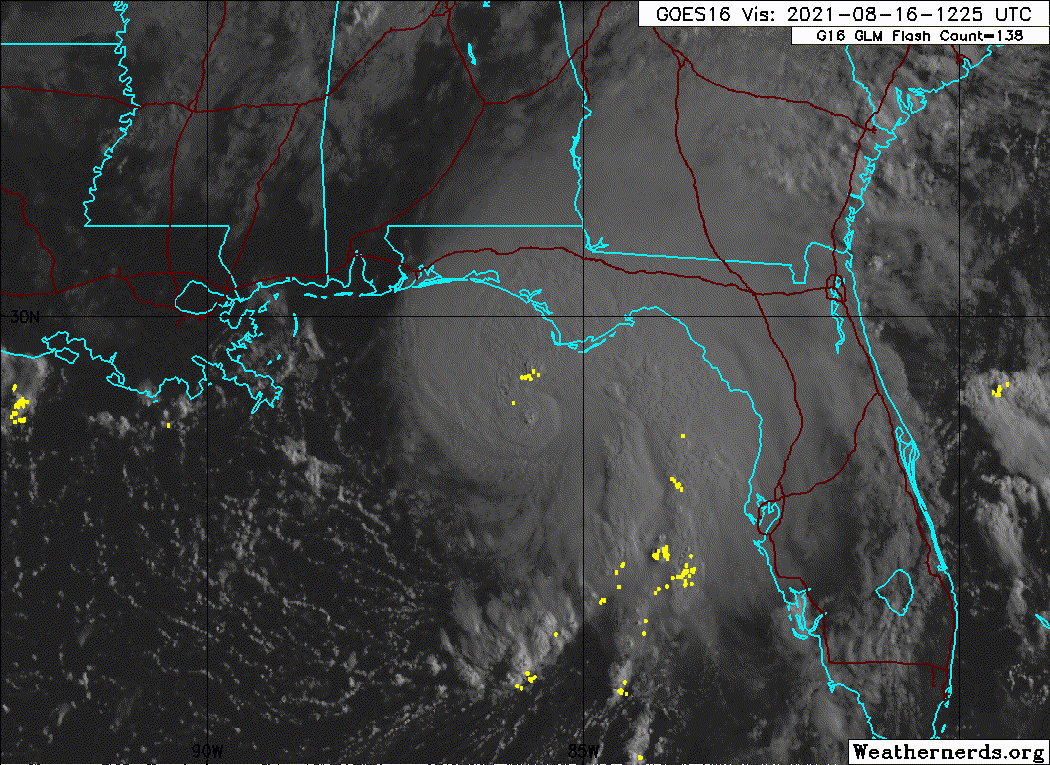
Potential for waterspouts with the storm cells over Apalachee Bay. That line will be moving north into Franklin and Wakulla Counties. 
Special Marine Warning
GMZ730-755-765-775-161745-
/O.NEW.KTAE.MA.W.0275.210816T1608Z-210816T1745Z/
BULLETIN - IMMEDIATE BROADCAST REQUESTED
Special Marine Warning
National Weather Service Tallahassee FL
1208 PM EDT Mon Aug 16 2021
The National Weather Service in Tallahassee has issued a
* Special Marine Warning for...
Apalachee Bay or Coastal Waters From Keaton Beach to Ochlockonee
River Fl out to 20 Nm...
Coastal Waters From Ochlockonee River to Apalachicola FL out to 20
Nm...
Coastal waters from Suwannee River to Keaton Beach out 20 NM...
Waters from Suwannee River to Apalachicola FL from 20 to 60 NM...
* Until 145 PM EDT.
* At 1208 PM EDT, severe thunderstorms capable of producing
waterspouts were located along a line extending from 14 nm
northwest of K Tower to 8 nm southeast of Buckeye Reef to 32 nm
northwest of Cedar Key to 11 nm west of Suwannee River, moving
northwest at 25 knots.
HAZARD...Waterspouts.
SOURCE...Radar indicated.
IMPACT...Waterspouts can quickly form and capsize boats...damage
vessels...and create suddenly higher waves. Make sure all
on board are in a secure location and wearing life
jackets.
* Locations impacted include...
Buckeye Reef, Horseshoe Beach, Marker 24 Barge and Suwannee River.
PRECAUTIONARY/PREPAREDNESS ACTIONS...
Thunderstorms can produce sudden waterspouts. Waterspouts can easily
overturn boats and create locally hazardous seas. Seek safe harbor
immediately.
Special Marine Warning
GMZ730-755-765-775-161745-
/O.NEW.KTAE.MA.W.0275.210816T1608Z-210816T1745Z/
BULLETIN - IMMEDIATE BROADCAST REQUESTED
Special Marine Warning
National Weather Service Tallahassee FL
1208 PM EDT Mon Aug 16 2021
The National Weather Service in Tallahassee has issued a
* Special Marine Warning for...
Apalachee Bay or Coastal Waters From Keaton Beach to Ochlockonee
River Fl out to 20 Nm...
Coastal Waters From Ochlockonee River to Apalachicola FL out to 20
Nm...
Coastal waters from Suwannee River to Keaton Beach out 20 NM...
Waters from Suwannee River to Apalachicola FL from 20 to 60 NM...
* Until 145 PM EDT.
* At 1208 PM EDT, severe thunderstorms capable of producing
waterspouts were located along a line extending from 14 nm
northwest of K Tower to 8 nm southeast of Buckeye Reef to 32 nm
northwest of Cedar Key to 11 nm west of Suwannee River, moving
northwest at 25 knots.
HAZARD...Waterspouts.
SOURCE...Radar indicated.
IMPACT...Waterspouts can quickly form and capsize boats...damage
vessels...and create suddenly higher waves. Make sure all
on board are in a secure location and wearing life
jackets.
* Locations impacted include...
Buckeye Reef, Horseshoe Beach, Marker 24 Barge and Suwannee River.
PRECAUTIONARY/PREPAREDNESS ACTIONS...
Thunderstorms can produce sudden waterspouts. Waterspouts can easily
overturn boats and create locally hazardous seas. Seek safe harbor
immediately.
1 likes
Fran '96, Georges '98, Gordon '00, Gabrielle '01, Charley '04, Frances '04, Jeanne '04, Barry '07, Fay '08, Debby '12, Matthew '16, Emily '17, Irma '17, Michael ‘18, Elsa ‘21, Fred ‘21, Mindy ‘21, Nicole ‘22, Idalia ‘23, Debby ‘24, Helene ‘24


Re: ATL: FRED - Tropical Storm - Discussion
Well, kudos to the NHC. They called this area out at least 4-5 days ago for landfall. They are amazing and take all the fun out of tracking, lol. Anyhows, stay safe in Florida.
6 likes
-
TallyTracker
- Category 2
- Posts: 787
- Joined: Thu Oct 11, 2018 2:46 pm
Re: ATL: FRED - Tropical Storm - Discussion
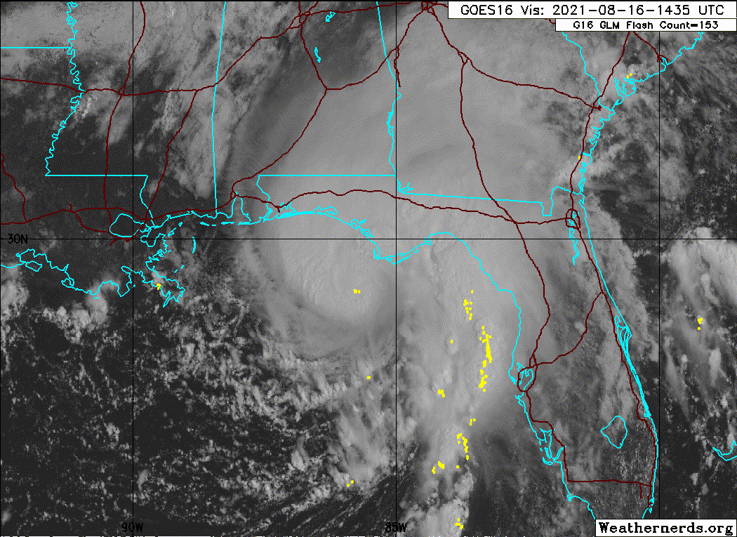
Looks like the center is gonna make landfall around Cape San Blas/Port St. Joe. Probably in the next 2-3 hours.
0 likes
Fran '96, Georges '98, Gordon '00, Gabrielle '01, Charley '04, Frances '04, Jeanne '04, Barry '07, Fay '08, Debby '12, Matthew '16, Emily '17, Irma '17, Michael ‘18, Elsa ‘21, Fred ‘21, Mindy ‘21, Nicole ‘22, Idalia ‘23, Debby ‘24, Helene ‘24
-
cheezyWXguy

- Category 5
- Posts: 6282
- Joined: Mon Feb 13, 2006 12:29 am
- Location: Dallas, TX
Re: ATL: FRED - Tropical Storm - Discussion
That southeast side is trying to slowly fill in on radar
0 likes
-
tolakram
- Admin

- Posts: 20186
- Age: 62
- Joined: Sun Aug 27, 2006 8:23 pm
- Location: Florence, KY (name is Mark)
Re: ATL: FRED - Tropical Storm - Discussion
0 likes
M a r k
- - - - -
Join us in chat: Storm2K Chatroom Invite. Android and IOS apps also available.
The posts in this forum are NOT official forecasts and should not be used as such. Posts are NOT endorsed by any professional institution or STORM2K.org. For official information and forecasts, please refer to NHC and NWS products.
-
Ian2401
- Category 1

- Posts: 321
- Joined: Thu Sep 14, 2017 5:55 pm
- Location: Tallahassee, Florida
- Contact:
Re: ATL: FRED - Tropical Storm - Discussion
why is this thread so dead?? you would think a landfalling TC would generate more traffic
3 likes
B.S. Meteorology from Florida State '24 // Current M.S. Meteorology student at Florida State
Research Interests: Rapid Intensification, TC Climatology, TC Modeling
Consult the NHC for official information
Research Interests: Rapid Intensification, TC Climatology, TC Modeling
Consult the NHC for official information

Re: ATL: FRED - Tropical Storm - Discussion
Seems that it jumped a tad looking like it wants to go between Mex Beach and PSJ
0 likes
Once I see the REDS and GREENS Converge on a Base Velocity. ... I'm There!!
This is NOT an Official Forecast....Just my Opinion. For official information, please refer to the NHC and NWS products.
HIGHLIGHTS : '13 El Reno Tornado : 2013 Storm Chaser Tour, Joaquin; SC flood event, Matthew '16, Lowcountry Snow storm Jan '18
This is NOT an Official Forecast....Just my Opinion. For official information, please refer to the NHC and NWS products.
HIGHLIGHTS : '13 El Reno Tornado : 2013 Storm Chaser Tour, Joaquin; SC flood event, Matthew '16, Lowcountry Snow storm Jan '18
Re: ATL: FRED - Tropical Storm - Discussion
Ian2401 wrote:why is this thread so dead?? you would think a landfalling TC would generate more traffic
No posters live between Destin and Tallahassee. Ain’t called the Forgotten Coast for nothing.
8 likes

Re: ATL: FRED - Tropical Storm - Discussion
70 knot Flight Level winds...not dure why recon won't go to the N side where the convection is mixing the winds to the surface.
1 likes

Re: ATL: FRED - Tropical Storm - Discussion
Ian2401 wrote:why is this thread so dead?? you would think a landfalling TC would generate more traffic
oddly this is not unusual, unless it is hitting a major area, almost very thread dies out just before landfall
2 likes
Just like Jon Snow..."I know nothing" except what I know, and most of what I know is gathered by the fine people of the NHC
Re: ATL: FRED - Tropical Storm - Discussion
Thanks to whoever posted Marks live on youtube, tried to scroll through couldn't find it! Been interesting to watch he is in PSJ ATM
1 likes
Once I see the REDS and GREENS Converge on a Base Velocity. ... I'm There!!
This is NOT an Official Forecast....Just my Opinion. For official information, please refer to the NHC and NWS products.
HIGHLIGHTS : '13 El Reno Tornado : 2013 Storm Chaser Tour, Joaquin; SC flood event, Matthew '16, Lowcountry Snow storm Jan '18
This is NOT an Official Forecast....Just my Opinion. For official information, please refer to the NHC and NWS products.
HIGHLIGHTS : '13 El Reno Tornado : 2013 Storm Chaser Tour, Joaquin; SC flood event, Matthew '16, Lowcountry Snow storm Jan '18
Re: ATL: FRED - Tropical Storm - Discussion
Ian2401 wrote:why is this thread so dead?? you would think a landfalling TC would generate more traffic
The answer to this question is human nature and reliably consistent
A.) Most people are primarily interested in storms that are going to bend trees in their neighborhood. Once they're out of contention, the available audience declines.
B.) The remaining audience in hot zone end up with other things to do like storm preps. that further reduces the already vastly smaller audience.
C.) During the storm a weather fanatic is going to be looking out their windows rather than looking at their computer screen
D.) Power outages provide an additional tailwind to this already robust phenomenon.
The answer is so simple it eludes us. If a storm comes my way I won't be on here much if at all...as was the case during Irma. I was on the porch with a bottle of Jack watching the oaks flex.
10 likes

Re: ATL: FRED - Tropical Storm - Discussion
KimmieLa wrote:Well, kudos to the NHC. They called this area out at least 4-5 days ago for landfall. They are amazing and take all the fun out of tracking, lol. Anyhows, stay safe in Florida.
They got the tropical storm warnings up yesterday morning early with all the appropriate advisories.
Just enough dry air and shear to keep Fred from becoming a more dangerous storm.
1 likes
-
SunnyThoughts
- Category 5
- Posts: 2263
- Joined: Wed Jul 09, 2003 12:42 pm
- Location: Pensacola, Florida
Re: ATL: FRED - Tropical Storm - Discussion
Storm cancel! The main page map (which has long been possessed) has wiped out Fred once and for all! 
Now he's back! But he ducked out the back door for a good 15-20 minutes
Now he's back! But he ducked out the back door for a good 15-20 minutes
Last edited by psyclone on Mon Aug 16, 2021 12:59 pm, edited 1 time in total.
1 likes
-
Sciencerocks
- Category 5
- Posts: 10186
- Age: 40
- Joined: Thu Jul 06, 2017 1:51 am
-
SunnyThoughts
- Category 5
- Posts: 2263
- Joined: Wed Jul 09, 2003 12:42 pm
- Location: Pensacola, Florida
Re: ATL: FRED - Tropical Storm - Discussion
Mark Sudduth and hurricanetrack is live on youtube at Port St. Joe for any interested.
https://www.youtube.com/watch?v=jtUHGvDBfC4
https://www.youtube.com/watch?v=jtUHGvDBfC4
5 likes
-
TallyTracker
- Category 2
- Posts: 787
- Joined: Thu Oct 11, 2018 2:46 pm
Re: ATL: FRED - Tropical Storm - Discussion
Sustained 46 mph with gusts to 59 mph at the St. George Island bridge being reported.
Tyndall AFB Tower C out in the Gulf south of St. George Island is reporting 52 mph sustained.
Tyndall AFB Tower C out in the Gulf south of St. George Island is reporting 52 mph sustained.
0 likes
Fran '96, Georges '98, Gordon '00, Gabrielle '01, Charley '04, Frances '04, Jeanne '04, Barry '07, Fay '08, Debby '12, Matthew '16, Emily '17, Irma '17, Michael ‘18, Elsa ‘21, Fred ‘21, Mindy ‘21, Nicole ‘22, Idalia ‘23, Debby ‘24, Helene ‘24
Re: ATL: FRED - Tropical Storm - Discussion
the dry air wrapping in should continue to push those eastern feeder bands into the big bend/ west coast area through the balance of the day. might some waterspout/brief tor risk in those regions
0 likes
Who is online
Users browsing this forum: No registered users and 9 guests