2021 Global Model Runs Discussion (Out thru day 16)

This is the general tropical discussion area. Anyone can take their shot at predicting a storms path.

Moderator: S2k Moderators

Forum rules

The posts in this forum are NOT official forecasts and should not be used as such. They are just the opinion of the poster and may or may not be backed by sound meteorological data. They are NOT endorsed by any professional institution or STORM2K. For official information, please refer to products from the National Hurricane Center and National Weather Service.

Help Support Storm2K
Message
Author
lsuhurricane
Category 1
Category 1
Posts: 251
Joined: Tue Aug 15, 2017 2:53 pm

Re: 2021 Global Model Runs Discussion (Out thru day 16)

#641 Postby lsuhurricane » Mon Aug 16, 2021 2:40 pm

AutoPenalti wrote:
lsuhurricane wrote:Some decent agreement between the above CMC storm at 240 hours and a few 12z Euro Ensembles.

All appear to be headed due west with stout ridging their north. Would certainly match climatology for that last week of August.

12z Euro ens hasn't updated yet.


It has, I'm watching it roll out real-time on a paid site.

Image
5 likes   

StormPyrate
Category 1
Category 1
Posts: 279
Joined: Sun May 27, 2018 8:41 pm
Location: Clearwater, FL

Re: 2021 Global Model Runs Discussion (Out thru day 16)

#642 Postby StormPyrate » Mon Aug 16, 2021 4:37 pm

lsuhurricane wrote:
AutoPenalti wrote:
lsuhurricane wrote:Some decent agreement between the above CMC storm at 240 hours and a few 12z Euro Ensembles.

All appear to be headed due west with stout ridging their north. Would certainly match climatology for that last week of August.

12z Euro ens hasn't updated yet.


It has, I'm watching it roll out real-time on a paid site.

https://i.ibb.co/JqdwTtP/Screen-Shot-2021-08-16-at-2-43-22-PM.png

I love the spaghettios how does one get access to that?
0 likes   
St Petersburg Florida

IcyTundra
Category 5
Category 5
Posts: 1205
Joined: Mon Jun 07, 2021 9:32 pm
Location: Dickinson, Texas

Re: 2021 Global Model Runs Discussion (Out thru day 16)

#643 Postby IcyTundra » Mon Aug 16, 2021 6:15 pm

This is out in GFS fantasyland but the 18Z GFS shows a weak TS making landfall along the Central Texas coast Saturday, August 28th.
0 likes   

lsuhurricane
Category 1
Category 1
Posts: 251
Joined: Tue Aug 15, 2017 2:53 pm

Re: 2021 Global Model Runs Discussion (Out thru day 16)

#644 Postby lsuhurricane » Mon Aug 16, 2021 6:17 pm

IcyTundra wrote:This is out in GFS fantasyland but the 18Z GFS shows a weak TS making landfall along the Central Texas coast Saturday, August 28th.


You can roughly trace this back to the same wave that will be traversing through the entire Atlantic. Same wave that generated feedback for the above Euro ensembles
0 likes   

User avatar
SoupBone
Category 5
Category 5
Posts: 3111
Joined: Tue Sep 20, 2005 5:24 pm

Re: 2021 Global Model Runs Discussion (Out thru day 16)

#645 Postby SoupBone » Mon Aug 16, 2021 6:20 pm

lsuhurricane wrote:
IcyTundra wrote:This is out in GFS fantasyland but the 18Z GFS shows a weak TS making landfall along the Central Texas coast Saturday, August 28th.


You can roughly trace this back to the same wave that will be traversing through the entire Atlantic. Same wave that generated feedback for the above Euro ensembles


Yeah, still lots of things can change by then as we all know. Can we fast forward to October yet?
0 likes   
Personal Forecast Disclaimer:
The posts in this forum are NOT official forecast and should not be used as such. They are just the opinion of the poster and may or may not be backed by sound meteorological data. They are NOT endorsed by any professional institution or storm2k.org. For official information, please refer to the NHC and NWS products.

User avatar
kevin
Category 5
Category 5
Posts: 2586
Age: 26
Joined: Wed Aug 28, 2019 4:35 am

Re: 2021 Global Model Runs Discussion (Out thru day 16)

#646 Postby kevin » Tue Aug 17, 2021 3:40 am

While none get very strong, the euro ensemble does show potential for MDR systems over the next 10 days.

Image
1 likes   

otowntiger
Category 5
Category 5
Posts: 1921
Joined: Tue Aug 31, 2004 7:06 pm

Re: 2021 Global Model Runs Discussion (Out thru day 16)

#647 Postby otowntiger » Tue Aug 17, 2021 7:42 am

kevin wrote:While none get very strong, the euro ensemble does show potential for MDR systems over the next 10 days.

https://i.imgur.com/MQLMUTV.png
interestingly it looks like a good number of those ensemble runs want to re-curve. I thought the Bermuda High was looking extra stout thus season?
1 likes   

AlphaToOmega
Category 5
Category 5
Posts: 1448
Joined: Sat Jun 26, 2021 10:51 am
Location: Somewhere in Massachusetts

Re: 2021 Global Model Runs Discussion (Out thru day 16)

#648 Postby AlphaToOmega » Tue Aug 17, 2021 7:52 am

otowntiger wrote:
kevin wrote:While none get very strong, the euro ensemble does show potential for MDR systems over the next 10 days.

https://i.imgur.com/MQLMUTV.png
interestingly it looks like a good number of those ensemble runs want to re-curve. I thought the Bermuda High was looking extra stout thus season?


Henri might be creating a weakness in the Azores High.
0 likes   

User avatar
Teban54
Category 5
Category 5
Posts: 3204
Joined: Sat May 19, 2018 1:19 pm

Re: 2021 Global Model Runs Discussion (Out thru day 16)

#649 Postby Teban54 » Tue Aug 17, 2021 10:57 am

AlphaToOmega wrote:
otowntiger wrote:
kevin wrote:While none get very strong, the euro ensemble does show potential for MDR systems over the next 10 days.

https://i.imgur.com/MQLMUTV.png
interestingly it looks like a good number of those ensemble runs want to re-curve. I thought the Bermuda High was looking extra stout thus season?


Henri might be creating a weakness in the Azores High.


In other words, if the ridge builds back in after Henri is gone... Watch out.
0 likes   

User avatar
Cpv17
Category 5
Category 5
Posts: 4979
Joined: Wed Dec 07, 2016 2:24 pm
Location: Wharton/El Campo, TX

Re: 2021 Global Model Runs Discussion (Out thru day 16)

#650 Postby Cpv17 » Tue Aug 17, 2021 11:21 am

Is that a CAG system the GFS wants to spin up and head towards Texas? It sure looks that way to me.
0 likes   

User avatar
gatorcane
S2K Supporter
S2K Supporter
Posts: 23691
Age: 47
Joined: Sun Mar 13, 2005 3:54 pm
Location: Boca Raton, FL

Re: 2021 Global Model Runs Discussion (Out thru day 16)

#651 Postby gatorcane » Tue Aug 17, 2021 12:41 pm

toad strangler wrote:gatorcane is a wee bit bullish about a land wave. Uh Oh :eek:


Looks like I was a wee too bullish. Even the CMC no longer develops. Conditions appear hostile between the Lesser Antilles and Africa still.
0 likes   

User avatar
captainbarbossa19
Professional-Met
Professional-Met
Posts: 1092
Age: 27
Joined: Wed Aug 21, 2019 11:09 pm
Location: Beaumont, TX

Re: 2021 Global Model Runs Discussion (Out thru day 16)

#652 Postby captainbarbossa19 » Tue Aug 17, 2021 1:14 pm

gatorcane wrote:
toad strangler wrote:gatorcane is a wee bit bullish about a land wave. Uh Oh :eek:


Looks like I was a wee too bullish. Even the CMC no longer develops. Conditions appear hostile between the Lesser Antilles and Africa still.


These waves may not do much until they move further west.
0 likes   

User avatar
gatorcane
S2K Supporter
S2K Supporter
Posts: 23691
Age: 47
Joined: Sun Mar 13, 2005 3:54 pm
Location: Boca Raton, FL

Re: 2021 Global Model Runs Discussion (Out thru day 16)

#653 Postby gatorcane » Tue Aug 17, 2021 1:42 pm

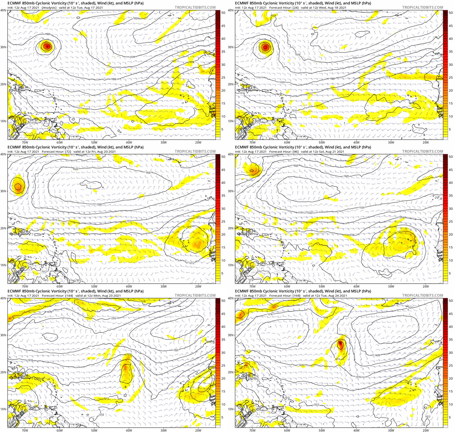
Just when is said that above, the Euro develops :lol:

Image
1 likes   

AutoPenalti
Category 5
Category 5
Posts: 4030
Age: 29
Joined: Mon Aug 17, 2015 4:16 pm
Location: Ft. Lauderdale, Florida

Re: 2021 Global Model Runs Discussion (Out thru day 16)

#654 Postby AutoPenalti » Tue Aug 17, 2021 1:48 pm

gatorcane wrote:Just when is said that above, the Euro develops :lol:

https://i.postimg.cc/XqPyGNsC/ecmwf-uv850-vort-eatl-fh0-168.gif

Looks like a break in the Ridge sends this OTS.

Seems once Henri loops around Bermuda, it will be leaving a bit of energy in the central atlantic that creates a small break allowing it to move away.
0 likes   
The posts in this forum are NOT official forecasts and should not be used as such. They are just the opinion of the poster and may or may not be backed by sound meteorological data. They are NOT endorsed by any professional institution or STORM2K. For official information, please refer to products from the NHC and NWS.


Model Runs Cheat Sheet:
GFS (5:30 AM/PM, 11:30 AM/PM)
HWRF, GFDL, UKMET, NAVGEM (6:30-8:00 AM/PM, 12:30-2:00 AM/PM)
ECMWF (1:45 AM/PM)

TCVN
is a weighted averaged

User avatar
Hammy
Category 5
Category 5
Posts: 5849
Age: 41
Joined: Fri May 25, 2012 5:25 pm
Contact:

Re: 2021 Global Model Runs Discussion (Out thru day 16)

#655 Postby Hammy » Tue Aug 17, 2021 3:47 pm

Euro seems to get us to at least 10 storms by September.
0 likes   
The above post is not official and should not be used as such. It is the opinion of the poster and may or may not be backed by sound meteorological data. It is not endorsed by any professional institution or storm2k.org. For official information, please refer to the NHC and NWS products.

User avatar
Cpv17
Category 5
Category 5
Posts: 4979
Joined: Wed Dec 07, 2016 2:24 pm
Location: Wharton/El Campo, TX

Re: 2021 Global Model Runs Discussion (Out thru day 16)

#656 Postby Cpv17 » Tue Aug 17, 2021 4:07 pm

captainbarbossa19 wrote:
gatorcane wrote:
toad strangler wrote:gatorcane is a wee bit bullish about a land wave. Uh Oh :eek:


Looks like I was a wee too bullish. Even the CMC no longer develops. Conditions appear hostile between the Lesser Antilles and Africa still.


These waves may not do much until they move further west.


That’ll be the case for the next few weeks till the MJO is favorable for development further east.
0 likes   

User avatar
aspen
Category 5
Category 5
Posts: 8818
Joined: Sat Oct 12, 2019 7:10 pm
Location: Connecticut, USA

Re: 2021 Global Model Runs Discussion (Out thru day 16)

#657 Postby aspen » Tue Aug 17, 2021 4:28 pm

12z Euro has Ida form in the MDR and recurve around 50W, and later Julian going through the Shredder but surviving into the Bahamas. The ensembles really like Ida and kinda support the possibility of other MDR/AEW storms in the next 10 days.
0 likes   
Irene '11 Sandy '12 Hermine '16 5/15/2018 Derecho Fay '20 Isaias '20 Elsa '21 Henri '21 Ida '21

I am only a meteorology enthusiast who knows a decent amount about tropical cyclones. Look to the professional mets, the NHC, or your local weather office for the best information.

User avatar
captainbarbossa19
Professional-Met
Professional-Met
Posts: 1092
Age: 27
Joined: Wed Aug 21, 2019 11:09 pm
Location: Beaumont, TX

Re: 2021 Global Model Runs Discussion (Out thru day 16)

#658 Postby captainbarbossa19 » Tue Aug 17, 2021 4:37 pm

aspen wrote:12z Euro has Ida form in the MDR and recurve around 50W, and later Julian going through the Shredder but surviving into the Bahamas. The ensembles really like Ida and kinda support the possibility of other MDR/AEW storms in the next 10 days.


Right. Some ensembles show the next system passing north of the Greater Antilles unlike the operational run.
1 likes   

User avatar
captainbarbossa19
Professional-Met
Professional-Met
Posts: 1092
Age: 27
Joined: Wed Aug 21, 2019 11:09 pm
Location: Beaumont, TX

Re: 2021 Global Model Runs Discussion (Out thru day 16)

#659 Postby captainbarbossa19 » Tue Aug 17, 2021 5:22 pm

gatorcane wrote:Just when is said that above, the Euro develops :lol:

https://i.postimg.cc/XqPyGNsC/ecmwf-uv850-vort-eatl-fh0-168.gif


The GFS shows dry air from the SAL outbreak wrapping into the wave and so it does not develop. I am not sure why the Euro shows it intensifying when it turns north into drier air. I am thinking that the wave behind this one might end up being Ida.
1 likes   

tolakram
Admin
Admin
Posts: 20009
Age: 62
Joined: Sun Aug 27, 2006 8:23 pm
Location: Florence, KY (name is Mark)

Re: 2021 Global Model Runs Discussion (Out thru day 16)

#660 Postby tolakram » Tue Aug 17, 2021 6:12 pm

GFS invents a new storm. Not sure I believe this, but the EUro has an echo as well, just off the east coast instead.

Image
0 likes   
M a r k
- - - - -
Join us in chat: Storm2K Chatroom Invite. Android and IOS apps also available.

The posts in this forum are NOT official forecasts and should not be used as such. Posts are NOT endorsed by any professional institution or STORM2K.org. For official information and forecasts, please refer to NHC and NWS products.


Return to “Talkin' Tropics”

Who is online

Users browsing this forum: duilaslol, JtSmarts, Sciencerocks, Yellow Evan and 34 guests