2021 Indicators: SST's / SAL / MSLP / Shear / Steering / Instability / Sat Images
Moderator: S2k Moderators
Forum rules

The posts in this forum are NOT official forecasts and should not be used as such. They are just the opinion of the poster and may or may not be backed by sound meteorological data. They are NOT endorsed by any professional institution or STORM2K. For official information, please refer to products from the National Hurricane Center and National Weather Service.
-
SFLcane

- S2K Supporter

- Posts: 10281
- Age: 48
- Joined: Sat Jun 05, 2010 1:44 pm
- Location: Lake Worth Florida
Re: 2021 Indicators: SST's / SAL / MSLP / Shear / Steering / Instability / Sat Images
For us tc trackers all we can do is continue to wait.
1 likes
-
AlphaToOmega
- Category 5

- Posts: 1448
- Joined: Sat Jun 26, 2021 10:51 am
- Location: Somewhere in Massachusetts
Re: 2021 Indicators: SST's / SAL / MSLP / Shear / Steering / Instability / Sat Images
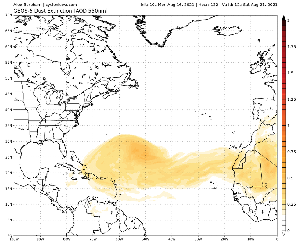
This is not a lot of SAL. The impacts of SAL on TC activity are being greatly exaggerated. Remember 2017 had a dust outbreak right before Harvey
8 likes

Re: 2021 Indicators: SST's / SAL / MSLP / Shear / Steering / Instability / Sat Images
SFLcane wrote:For us tc trackers all we can do is continue to wait.
Or track Grace and Henri, both of which will be around for quite some time and have at least some chance to become hurricanes.
6 likes
Irene '11 Sandy '12 Hermine '16 5/15/2018 Derecho Fay '20 Isaias '20 Elsa '21 Henri '21 Ida '21
I am only a meteorology enthusiast who knows a decent amount about tropical cyclones. Look to the professional mets, the NHC, or your local weather office for the best information.
I am only a meteorology enthusiast who knows a decent amount about tropical cyclones. Look to the professional mets, the NHC, or your local weather office for the best information.
-
AlphaToOmega
- Category 5
- Posts: 1448
- Joined: Sat Jun 26, 2021 10:51 am
- Location: Somewhere in Massachusetts
Re: 2021 Indicators: SST's / SAL / MSLP / Shear / Steering / Instability / Sat Images
Unlike in July, the MJO seems to be favorable for the rest of August. August is NOT going to shut down. July was a product of an unfavorable MJO AND a lot of SAL. Activity will ramp up significantly after August 20. It is becoming EXTREMELY dangerous to assume the best-case scenario.
2 likes
-
tolakram
- Admin

- Posts: 20186
- Age: 62
- Joined: Sun Aug 27, 2006 8:23 pm
- Location: Florence, KY (name is Mark)
Re: 2021 Indicators: SST's / SAL / MSLP / Shear / Steering / Instability / Sat Images
AlphaToOmega wrote:Unlike in July, the MJO seems to be favorable for the rest of August. August is NOT going to shut down. July was a product of an unfavorable MJO AND a lot of SAL. Activity will ramp up significantly after August 20. It is becoming EXTREMELY dangerous to assume the best-case scenario.
That's your opinion, we'll see in a couple of weeks. There's nothing wrong with people giving their analysis here and it's not extremely dangerous to assume a best case scenario here. Let's just stop that nonsense right now. This is an indicators discussion thread.
4 likes
M a r k
- - - - -
Join us in chat: Storm2K Chatroom Invite. Android and IOS apps also available.
The posts in this forum are NOT official forecasts and should not be used as such. Posts are NOT endorsed by any professional institution or STORM2K.org. For official information and forecasts, please refer to NHC and NWS products.
-
Category5Kaiju

- Category 5
- Posts: 4335
- Joined: Thu Dec 24, 2020 12:45 pm
- Location: Seattle during the summer, Phoenix during the winter
Re: 2021 Indicators: SST's / SAL / MSLP / Shear / Steering / Instability / Sat Images
I personally do not find anything anomalous or strange with that dust plume, prior active seasons iirc have had that happen, and if last year had major dust problems but still produced a very active season in the end (albeit backloaded), then I don’t see why this dust plume would be anything significant for this season.
1 likes
Unless explicitly stated, all information in my posts is based on my own opinions and observations. Tropical storms and hurricanes can be extremely dangerous. Refer to an accredited weather research agency or meteorologist if you need to make serious decisions regarding an approaching storm.
-
Iceresistance

- Category 5
- Posts: 9592
- Age: 22
- Joined: Sat Oct 10, 2020 9:45 am
- Location: Tecumseh, OK/Norman, OK
Re: 2021 Indicators: SST's / SAL / MSLP / Shear / Steering / Instability / Sat Images
Mid-August North Atlantic Global SST anomalies.
The square area between 80°W to 45°W & from 25°N to 50°N is WAY above normal, & the GoM is STILL boiling . . .

The square area between 80°W to 45°W & from 25°N to 50°N is WAY above normal, & the GoM is STILL boiling . . .
0 likes
Bill 2015 & Beta 2020
Winter 2020-2021
All observations are in Tecumseh, OK unless otherwise noted.
Winter posts are focused mainly for Oklahoma & Texas.
Take any of my forecasts with a grain of salt, refer to the NWS, SPC, and NHC for official information
Never say Never with weather! Because ANYTHING is possible!
Winter 2020-2021
All observations are in Tecumseh, OK unless otherwise noted.
Winter posts are focused mainly for Oklahoma & Texas.
Take any of my forecasts with a grain of salt, refer to the NWS, SPC, and NHC for official information
Never say Never with weather! Because ANYTHING is possible!
-
SFLcane
- S2K Supporter
- Posts: 10281
- Age: 48
- Joined: Sat Jun 05, 2010 1:44 pm
- Location: Lake Worth Florida
Re: 2021 Indicators: SST's / SAL / MSLP / Shear / Steering / Instability / Sat Images
AlphaToOmega wrote:This is not a lot of SAL. The impacts of SAL on TC activity are being greatly exaggerated. Remember 2017 had a dust outbreak right before Harvey
https://i.postimg.cc/TwP32VJ3/geos5-atl-dustext-2021081612-f122.png
Have a link for the Sal graphic in 2017 before Harvey, Irma?
0 likes
-
SFLcane
- S2K Supporter
- Posts: 10281
- Age: 48
- Joined: Sat Jun 05, 2010 1:44 pm
- Location: Lake Worth Florida
Re: 2021 Indicators: SST's / SAL / MSLP / Shear / Steering / Instability / Sat Images
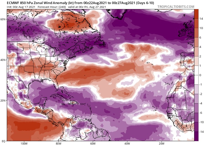
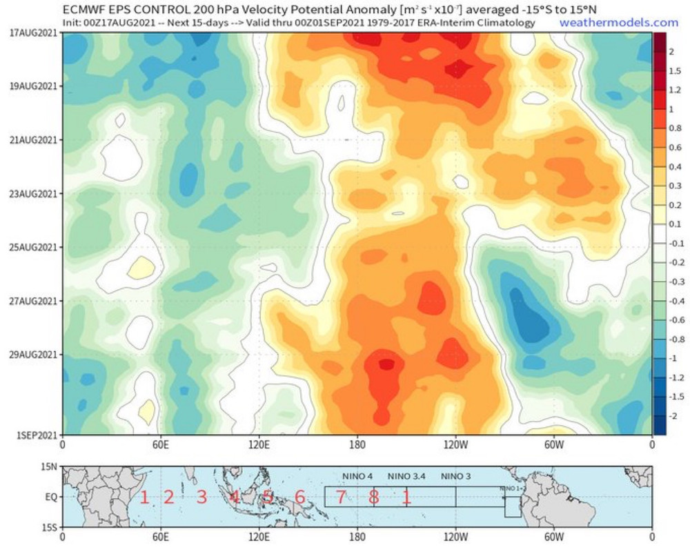
aspen wrote:SFLcane wrote:Things are either gonna explode eventually or this will be a memorable September upcoming. One thing I can see now is the rest of August could be shut down with a big trade surge inbound.
https://i.postimg.cc/PxFGhtNM/5-EE8-CC92-1-D37-453-F-BE69-22-B22-FDE99-AB.jpg
If you look at the EPS, after the suppressed Kelvin Wave, there's another CCKW right at the end of the month. So September 1-10 would be the window I would look for at this point. If that doesn't produce a long tracker or two, we're looking at an underachieving season.
https://i.postimg.cc/zfQZYzyF/F516-B099-FC32-467-D-B9-E8-776-E12-FF0692.jpg
What do you mean a “big trade surge”? All of those are negative anomalies.
Positive u wind is westerly and Negative is easterly. Negative anomalies = stronger winds from the east. Given the mean winds are already out of the east there, it means a strong surge of easterly low level winds.
0 likes
-
Category5Kaiju
- Category 5
- Posts: 4335
- Joined: Thu Dec 24, 2020 12:45 pm
- Location: Seattle during the summer, Phoenix during the winter
Re: 2021 Indicators: SST's / SAL / MSLP / Shear / Steering / Instability / Sat Images
Also I am not sure if it's just me, but doesn't it seem like many recent years have been backloaded, with the strongest hurricanes occurring in late September to even November? 2011, 2012 2014, 2015. 2016, 2017, 2018, and 2020 come into mind, so maybe the SAL and what not (along with the developing La Nina) we are seeing now would simply push the season's activity slightly down the calendar with perhaps the strongest storm of the season occurring late rather than shutting down or limiting this season's potential in a significant manner?
0 likes
Unless explicitly stated, all information in my posts is based on my own opinions and observations. Tropical storms and hurricanes can be extremely dangerous. Refer to an accredited weather research agency or meteorologist if you need to make serious decisions regarding an approaching storm.
-
cycloneye

- Admin
- Posts: 149508
- Age: 69
- Joined: Thu Oct 10, 2002 10:54 am
- Location: San Juan, Puerto Rico
Re: 2021 Indicators: SST's / SAL / MSLP / Shear / Steering / Instability / Sat Images
1 likes
Visit the Caribbean-Central America Weather Thread where you can find at first post web cams,radars
and observations from Caribbean basin members Click Here
and observations from Caribbean basin members Click Here
-
tolakram
- Admin
- Posts: 20186
- Age: 62
- Joined: Sun Aug 27, 2006 8:23 pm
- Location: Florence, KY (name is Mark)
Re: 2021 Indicators: SST's / SAL / MSLP / Shear / Steering / Instability / Sat Images
The more convection over Africa the more SAL (not a perfect match) and the more outflow, meaning more trade winds. This seems to trend well with more western development. In slower years perhaps there's a better chance of long trackers? I'm not sure if this correlates or not, but it seems if the wave train is super active then most activity will be in the western half of the basin.
1 likes
M a r k
- - - - -
Join us in chat: Storm2K Chatroom Invite. Android and IOS apps also available.
The posts in this forum are NOT official forecasts and should not be used as such. Posts are NOT endorsed by any professional institution or STORM2K.org. For official information and forecasts, please refer to NHC and NWS products.
- - - - -
Join us in chat: Storm2K Chatroom Invite. Android and IOS apps also available.
The posts in this forum are NOT official forecasts and should not be used as such. Posts are NOT endorsed by any professional institution or STORM2K.org. For official information and forecasts, please refer to NHC and NWS products.
-
Category5Kaiju
- Category 5
- Posts: 4335
- Joined: Thu Dec 24, 2020 12:45 pm
- Location: Seattle during the summer, Phoenix during the winter
Re: 2021 Indicators: SST's / SAL / MSLP / Shear / Steering / Instability / Sat Images
tolakram wrote:The more convection over Africa the more SAL (not a perfect match) and the more outflow, meaning more trade winds. This seems to trend well with more western development. In slower years perhaps there's a better chance of long trackers? I'm not sure if this correlates or not, but it seems if the wave train is super active then most activity will be in the western half of the basin.
Interestingly, it seems like the years with a phenomenal NS count (2005 and 2020) were west-focused with little intense MDR activity. Years like 2004 and 2017 were long-tracker heavy, but in total their NS counts were not very striking (15 and 17 respectively).
1 likes
Unless explicitly stated, all information in my posts is based on my own opinions and observations. Tropical storms and hurricanes can be extremely dangerous. Refer to an accredited weather research agency or meteorologist if you need to make serious decisions regarding an approaching storm.
-
SFLcane
- S2K Supporter
- Posts: 10281
- Age: 48
- Joined: Sat Jun 05, 2010 1:44 pm
- Location: Lake Worth Florida
Re: 2021 Indicators: SST's / SAL / MSLP / Shear / Steering / Instability / Sat Images
Anyone have an SAL outbreak archive form 2017 before we had that outbreak Harvey, Irma etc.
0 likes
-
Category5Kaiju
- Category 5
- Posts: 4335
- Joined: Thu Dec 24, 2020 12:45 pm
- Location: Seattle during the summer, Phoenix during the winter
Re: 2021 Indicators: SST's / SAL / MSLP / Shear / Steering / Instability / Sat Images
SFLcane wrote:Anyone have an SAL outbreak archive form 2017 before we had that outbreak Harvey, Irma etc.
Weeniepatrol's recent post (#2572) has a snapshot of the massive dust plume roughly 12 days before Irma formed; not exactly sure where or how weeniepatrol saved the SAL graphic though?
0 likes
Unless explicitly stated, all information in my posts is based on my own opinions and observations. Tropical storms and hurricanes can be extremely dangerous. Refer to an accredited weather research agency or meteorologist if you need to make serious decisions regarding an approaching storm.

Re: 2021 Indicators: SST's / SAL / MSLP / Shear / Steering / Instability / Sat Images
Category5Kaiju wrote:Also I am not sure if it's just me, but doesn't it seem like many recent years have been backloaded, with the strongest hurricanes occurring in late September to even November? 2011, 2012 2014, 2015. 2016, 2017, 2018, and 2020 come into mind, so maybe the SAL and what not (along with the developing La Nina) we are seeing now would simply push the season's activity slightly down the calendar with perhaps the strongest storm of the season occurring late rather than shutting down or limiting this season's potential in a significant manner?
I did some calculations of the number of Oct - Dec named storms since 2000, including the % of the total number of storms of that year. Same goes for major hurricanes. For simplicity I only included them if their formation date was in October or beyond. I simply combined it using "# named Oct-Dec storms * % of named storms + 5 * #MH oct-Dec * % of total MH" to get an indication for how backloaded a season was, expressed with a "Backload score". I added a factor 5 to the MH value to roughly reflect the average ratio of MHs to other tropical storms.
Year / Backload score / # named Oct-Dec storms / % of total named storms / # major Oct-Dec storms / % of total MH
2000 / 1.1 / 4 / 27% / 0 / 0%
2001 / 8.3 / 7 / 47% / 2 / 50%
2002 / 0.0 / 0 / 0% / 0 / 0%
2003 / 1.6 / 5 / 31% / 0 / 0%
2004 / 0.6 / 3 / 20% / 0 / 0%
2005 / 7.2 / 11 / 39% / 2 / 29%
2006 / 0.0 / 0 / 0% / 0 / 0%
2007 / 0.3 / 2 / 13% / 0 / 0%
2008 / 5.6 / 5 / 31% / 2 / 40%
2009 / 1.0 / 3 / 33% / 0 / 0%
2010 / 1.3 / 5 / 26% / 0 / 0%
2011 / 0.2 / 2 / 11% / 0 / 0%
2012 / 3.8 / 5 / 26% / 1 / 50%
2013 / 1.2 / 4 / 29% / 0 / 0%
2014 / 3.6 / 3 / 38% / 1 / 50%
2015 / 0.1 / 1 / 9% / 0 / 0%
2016 / 5.3 / 2 / 13% / 2 / 50%
2017 / 1.8 / 4 / 24% / 1 / 17%
2018 / 3.1 / 3 / 20% / 1 / 50%
2019 / 2.7 / 7 / 39% / 0 / 0%
2020 / 19.4 / 7 / 23% / 5 / 71%
If you plot it you do get an upwards trend, but this is mainly caused by 2020, which was so backloaded it's ridiculous. No other season came even close to what the last months of 2020 did. If you remove 2020 you get a near constant trend, even downwards by -0.008 "Backload score" per year, but that's so small that it's negigible. So it seems that, if this methodology is used, at least in the 2000 - 2020 timeline there is no clear increase in backloaded seasons (if we define backloaded as starting on the 1st of October). Perhaps it would be slightly different if you also include the last week of September in the calculation, since then you also get storms like Joaquin and Matthew from recent years. And it might also shift a bit if you only consider the peak date of a storm instead of its formation date, but that was a bit too much work for me to do now

Last edited by kevin on Tue Aug 17, 2021 9:49 am, edited 2 times in total.
4 likes

Re: 2021 Indicators: SST's / SAL / MSLP / Shear / Steering / Instability / Sat Images
AlphaToOmega wrote:Unlike in July, the MJO seems to be favorable for the rest of August. August is NOT going to shut down. July was a product of an unfavorable MJO AND a lot of SAL. Activity will ramp up significantly after August 20. It is becoming EXTREMELY dangerous to assume the best-case scenario.
Why are you being argumentative over people posting opposing opinions? You're posting definitive statements, which is worse. It does appear that several pieces of the puzzle are not coming together for the next week and a half for sure, beyond that is anyone's best guess.
https://twitter.com/JasonDunning/status/1427609769699856387
2 likes
Personal Forecast Disclaimer:
The posts in this forum are NOT official forecast and should not be used as such. They are just the opinion of the poster and may or may not be backed by sound meteorological data. They are NOT endorsed by any professional institution or storm2k.org. For official information, please refer to the NHC and NWS products.
The posts in this forum are NOT official forecast and should not be used as such. They are just the opinion of the poster and may or may not be backed by sound meteorological data. They are NOT endorsed by any professional institution or storm2k.org. For official information, please refer to the NHC and NWS products.
-
SFLcane
- S2K Supporter
- Posts: 10281
- Age: 48
- Joined: Sat Jun 05, 2010 1:44 pm
- Location: Lake Worth Florida
Re: 2021 Indicators: SST's / SAL / MSLP / Shear / Steering / Instability / Sat Images
weeniepatrol wrote::uarrow:
https://i.imgur.com/8eRGifv.jpg
This current SAL outbreak is even bigger than that. But certainly it could flip after.
0 likes
-
AutoPenalti
- Category 5
- Posts: 4091
- Age: 29
- Joined: Mon Aug 17, 2015 4:16 pm
- Location: Ft. Lauderdale, Florida
Re: 2021 Indicators: SST's / SAL / MSLP / Shear / Steering / Instability / Sat Images
Man, it has become tradition for me to view the Irma thread every season when posts become bearish.
4 likes
The posts in this forum are NOT official forecasts and should not be used as such. They are just the opinion of the poster and may or may not be backed by sound meteorological data. They are NOT endorsed by any professional institution or STORM2K. For official information, please refer to products from the NHC and NWS.
Model Runs Cheat Sheet:
GFS (5:30 AM/PM, 11:30 AM/PM)
HWRF, GFDL, UKMET, NAVGEM (6:30-8:00 AM/PM, 12:30-2:00 AM/PM)
ECMWF (1:45 AM/PM)
TCVN is a weighted averaged
-
toad strangler

- S2K Supporter
- Posts: 4546
- Joined: Sun Jul 28, 2013 3:09 pm
- Location: Earth
- Contact:
Re: 2021 Indicators: SST's / SAL / MSLP / Shear / Steering / Instability / Sat Images
AutoPenalti wrote:Man, it has become tradition for me to view the Irma thread every season when posts become bearish.
Yesh, I'm starting to get bearish reading all of this. I might have to brush up on it too
1 likes
My Weather Station
https://www.wunderground.com/dashboard/pws/KFLPORTS603
https://www.wunderground.com/dashboard/pws/KFLPORTS603
Who is online
Users browsing this forum: No registered users and 284 guests