Just to show how little we really know about what is going to happen, here is a tweet from experts around this time in 2017:
https://twitter.com/MJVentrice/status/899013298057818118
Remember what formed on August 30th that year?
2021 Indicators: SST's / SAL / MSLP / Shear / Steering / Instability / Sat Images
Moderator: S2k Moderators
Forum rules

The posts in this forum are NOT official forecasts and should not be used as such. They are just the opinion of the poster and may or may not be backed by sound meteorological data. They are NOT endorsed by any professional institution or STORM2K. For official information, please refer to products from the National Hurricane Center and National Weather Service.
-
captainbarbossa19

- Professional-Met

- Posts: 1094
- Age: 27
- Joined: Wed Aug 21, 2019 11:09 pm
- Location: Beaumont, TX

Re: 2021 Indicators: SST's / SAL / MSLP / Shear / Steering / Instability / Sat Images
Three active named storms -- one of which could end up as a major -- and an active wave train and a low ITCZ...quite an active look despite the SAL plume.

5 likes
Irene '11 Sandy '12 Hermine '16 5/15/2018 Derecho Fay '20 Isaias '20 Elsa '21 Henri '21 Ida '21
I am only a meteorology enthusiast who knows a decent amount about tropical cyclones. Look to the professional mets, the NHC, or your local weather office for the best information.
I am only a meteorology enthusiast who knows a decent amount about tropical cyclones. Look to the professional mets, the NHC, or your local weather office for the best information.
-
Category5Kaiju

- Category 5

- Posts: 4335
- Joined: Thu Dec 24, 2020 12:45 pm
- Location: Seattle during the summer, Phoenix during the winter
Re: 2021 Indicators: SST's / SAL / MSLP / Shear / Steering / Instability / Sat Images
gatorcane wrote:The GFS shows a very active EPAC in the long-range = less active Atlantic
GFS really seems to believe in the American Standing Wave pattern that was dominant in the 80s and 90s, but considering how it has in recent times loved to blow up every cloud in the EPAC into a hurricane (with Linda the only storm it really predicted well in presence and strength so far), I personally would not put much stock into believing that to verify, let alone during a -ENSO, -PDO, and -PMM year.
Last edited by Category5Kaiju on Tue Aug 17, 2021 12:19 pm, edited 1 time in total.
5 likes
Unless explicitly stated, all information in my posts is based on my own opinions and observations. Tropical storms and hurricanes can be extremely dangerous. Refer to an accredited weather research agency or meteorologist if you need to make serious decisions regarding an approaching storm.
-
SFLcane

- S2K Supporter

- Posts: 10281
- Age: 48
- Joined: Sat Jun 05, 2010 1:44 pm
- Location: Lake Worth Florida
Re: 2021 Indicators: SST's / SAL / MSLP / Shear / Steering / Instability / Sat Images
captainbarbossa19 wrote:Just to show how little we really know about what is going to happen, here is a tweet from experts around this time in 2017:
https://twitter.com/MJVentrice/status/899013298057818118?ref_src=twsrc%5Etfw%7Ctwcamp%5Etweetembed%7Ctwterm%5E899013298057818118%7Ctwgr%5E%7Ctwcon%5Es1_c10&ref_url=http%3A%2F%2Fstorm2k.org%2Fphpbb2%2FEmbedTweet.html899013298057818118
Remember what formed on August 30th that year?
They’re are some similarities but the difference being that the Atlantic was a lot warmer that year. Which kind of made a flip inevitable. The MDR will be near average after this trade burst.
0 likes
-
AlphaToOmega
- Category 5
- Posts: 1448
- Joined: Sat Jun 26, 2021 10:51 am
- Location: Somewhere in Massachusetts
Re: 2021 Indicators: SST's / SAL / MSLP / Shear / Steering / Instability / Sat Images
If this SAL dust outbreak will affect anything, it will probably just be where storms develop. There was Saharan Dust when Fred, Grace, and Henri developed; they just developed in the Western Atlantic. If this SAL dust outbreak will affect anything, it will likely just shift development from the MDR to the Western Atlantic. The ITCZ has been pretty far south this year.
0 likes
-
Category5Kaiju
- Category 5
- Posts: 4335
- Joined: Thu Dec 24, 2020 12:45 pm
- Location: Seattle during the summer, Phoenix during the winter
Re: 2021 Indicators: SST's / SAL / MSLP / Shear / Steering / Instability / Sat Images

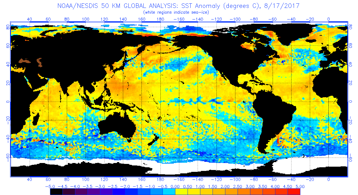
2017 did have a warmer MDR, but 2021 looks to have a warmer subtropics and a warmer West Atlantic in general at about this same time of the year. Maybe this is an indicator of heavier W Atlantic activity this year than in 2017?
2 likes
Unless explicitly stated, all information in my posts is based on my own opinions and observations. Tropical storms and hurricanes can be extremely dangerous. Refer to an accredited weather research agency or meteorologist if you need to make serious decisions regarding an approaching storm.

Re: 2021 Indicators: SST's / SAL / MSLP / Shear / Steering / Instability / Sat Images
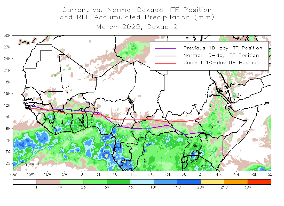
So much for the ITCZ being suppressed to the south this year
0 likes
-
Category5Kaiju
- Category 5
- Posts: 4335
- Joined: Thu Dec 24, 2020 12:45 pm
- Location: Seattle during the summer, Phoenix during the winter
Re: 2021 Indicators: SST's / SAL / MSLP / Shear / Steering / Instability / Sat Images
WiscoWx02 wrote:https://www.cpc.ncep.noaa.gov/products/international/itf/itcz.jpg
So much for the ITCZ being suppressed to the south this year
Looks like we’re about normal…
0 likes
Unless explicitly stated, all information in my posts is based on my own opinions and observations. Tropical storms and hurricanes can be extremely dangerous. Refer to an accredited weather research agency or meteorologist if you need to make serious decisions regarding an approaching storm.
-
storminabox
- Category 1

- Posts: 263
- Joined: Sun Jul 09, 2017 10:50 pm
Re: 2021 Indicators: SST's / SAL / MSLP / Shear / Steering / Instability / Sat Images
A lot of posts are make it seem like nothing has formed at all this month. There is plenty of activity out there now and Grace has the potential to be a pretty formidable hurricane. The season is still on track to be busy. This robust late August SAL event reminds me quite a bit of 2017. Once all the SAL from that outbreak was exhausted, there was not much left, and then the season went into overdrive. Who knows what will ultimately occur though; that’s what makes studying the tropics so invigorating.
7 likes
-
AlphaToOmega
- Category 5
- Posts: 1448
- Joined: Sat Jun 26, 2021 10:51 am
- Location: Somewhere in Massachusetts
Re: 2021 Indicators: SST's / SAL / MSLP / Shear / Steering / Instability / Sat Images
The SAL outbreak will not affect the Western Atlantic. Hurricane Harvey rapidly intensified in the Gulf of Mexico during the August 2017 SAL outbreak. Even if a wave does not develop in the MDR, it could still develop in the Western Atlantic.
0 likes
-
CyclonicFury

- Category 5
- Posts: 2035
- Age: 27
- Joined: Sun Jul 02, 2017 12:32 pm
- Location: NC
- Contact:
Re: 2021 Indicators: SST's / SAL / MSLP / Shear / Steering / Instability / Sat Images
storminabox wrote:A lot of posts are make it seem like nothing has formed at all this month. There is plenty of activity out there now and Grace has the potential to be a pretty formidable hurricane. The season is still on track to be busy. This robust late August SAL event reminds me quite a bit of 2017. Once all the SAL from that outbreak was exhausted, there was not much left, and then the season went into overdrive. Who knows what will ultimately occur though; that’s what makes studying the tropics so invigorating.
Not every year is like 2004 and has August major hurricanes in the MDR threatening the CONUS. August averages about 3-4 storms. So far this month 3 named storms have formed and there is still 2 weeks to go. 2 of the 3 storms look like they have a chance to become hurricanes, and the one that did not was a strong tropical storm that hit Florida. I remember similar comments in August of 2017, saying the MDR was unfavorable because Gert did well in the subtropics and Harvey struggled there. Even in hyperactive seasons, you can get breaks in activity due to intraseasonal variation, such as what we saw in late September in both 2005 and 2020. This season was never likely going to be as active as those years. We are only just entering the active part of the season. August 2018 was practically dead before September and October had Florence, Michael, and several other hurricanes that didn't threaten land. Irma did not form in the MDR until August 30, everything before that struggled. Global models haven't been particularly great with genesis this season either. We have a long way to go, and I don't see any reason to "season cancel" right now.
10 likes
NCSU B.S. in Meteorology Class of 2021. Tropical weather blogger at http://www.cyclonicfury.com. My forecasts and thoughts are NOT official, for official forecasts please consult the National Hurricane Center.
-
Category5Kaiju
- Category 5
- Posts: 4335
- Joined: Thu Dec 24, 2020 12:45 pm
- Location: Seattle during the summer, Phoenix during the winter
Re: 2021 Indicators: SST's / SAL / MSLP / Shear / Steering / Instability / Sat Images
storminabox wrote:A lot of posts are make it seem like nothing has formed at all this month. There is plenty of activity out there now and Grace has the potential to be a pretty formidable hurricane. The season is still on track to be busy. This robust late August SAL event reminds me quite a bit of 2017. Once all the SAL from that outbreak was exhausted, there was not much left, and then the season went into overdrive. Who knows what will ultimately occur though; that’s what makes studying the tropics so invigorating.
100% agree; it’s not like we are still waiting for Fred. If that were the case, then I can see where people could begin to doubt this season’s potential, but quite recently we literally had three storms active at once. Henri could genuinely become a hurricane and bears watching in New England, while Mexico must be on alert for Grace, which will be going over 30-31 C bath waters with extremely high UOHC. The West Atlantic seems more than favorable for potent hurricanes, and based on looking at the sst anomaly in the MDR for years like 1996, 1999, and 2003 and comparing them to this year now, nothing really seems to suggest that the MDR will be extremely hostile and dead for the rest of the season.
7 likes
Unless explicitly stated, all information in my posts is based on my own opinions and observations. Tropical storms and hurricanes can be extremely dangerous. Refer to an accredited weather research agency or meteorologist if you need to make serious decisions regarding an approaching storm.
-
captainbarbossa19
- Professional-Met
- Posts: 1094
- Age: 27
- Joined: Wed Aug 21, 2019 11:09 pm
- Location: Beaumont, TX
Re: 2021 Indicators: SST's / SAL / MSLP / Shear / Steering / Instability / Sat Images
So this is a video I found on Wikipedia that shows satellite imagery from August 10th until late September in 2017. This really shows how everything really got going after August 20th.
https://upload.wikimedia.org/wikipedia/commons/3/3e/Hurricane_Tracks_from_2017_with_Precipitation_and_Cloud_Data.webm
https://upload.wikimedia.org/wikipedia/commons/3/3e/Hurricane_Tracks_from_2017_with_Precipitation_and_Cloud_Data.webm
2 likes

Re: 2021 Indicators: SST's / SAL / MSLP / Shear / Steering / Instability / Sat Images
WiscoWx02 wrote:https://www.cpc.ncep.noaa.gov/products/international/itf/itcz.jpg
So much for the ITCZ being suppressed to the south this year
Last few years have been quite a bit farther north than normal.
2 likes
The above post is not official and should not be used as such. It is the opinion of the poster and may or may not be backed by sound meteorological data. It is not endorsed by any professional institution or storm2k.org. For official information, please refer to the NHC and NWS products.
-
Category5Kaiju
- Category 5
- Posts: 4335
- Joined: Thu Dec 24, 2020 12:45 pm
- Location: Seattle during the summer, Phoenix during the winter
Re: 2021 Indicators: SST's / SAL / MSLP / Shear / Steering / Instability / Sat Images
So at this point I think it's safe to say that the "Fred 2.0" or the "Grace will dissipate and die over Hispaniola" comments earlier this week have aged like milk left under the Florida sun, unfortunately. If anything, Grace may very well take a decent shot at being the nasty, typical August major hurricane.
5 likes
Unless explicitly stated, all information in my posts is based on my own opinions and observations. Tropical storms and hurricanes can be extremely dangerous. Refer to an accredited weather research agency or meteorologist if you need to make serious decisions regarding an approaching storm.
-
Iceresistance

- Category 5
- Posts: 9592
- Age: 22
- Joined: Sat Oct 10, 2020 9:45 am
- Location: Tecumseh, OK/Norman, OK
Re: 2021 Indicators: SST's / SAL / MSLP / Shear / Steering / Instability / Sat Images
Category5Kaiju wrote:So at this point I think it's safe to say that the "Fred 2.0" or the "Grace will dissipate and die over Hispaniola" comments earlier this week have aged like milk left under the Florida sun, unfortunately. If anything, Grace may very well take a decent shot at being the nasty, typical August major hurricane.
My thoughts when Fred was struggling: "If Fred can clear Cuba & regenerate back into a Tropical Storm, it will steadily get stronger because of the SST's but the Dryness & wind shear will limit it somewhat."
Grace: "Even though that Grace is a Tropical Depression, she has a good chance of getting stronger again, I've noticed that the OHC is high just west of Jamaica, if Grace manages to make it there as a Tropical Storm or even a Depression, she may explode into something really bad for Mexico. . ."
3 likes
Bill 2015 & Beta 2020
Winter 2020-2021
All observations are in Tecumseh, OK unless otherwise noted.
Winter posts are focused mainly for Oklahoma & Texas.
Take any of my forecasts with a grain of salt, refer to the NWS, SPC, and NHC for official information
Never say Never with weather! Because ANYTHING is possible!
Winter 2020-2021
All observations are in Tecumseh, OK unless otherwise noted.
Winter posts are focused mainly for Oklahoma & Texas.
Take any of my forecasts with a grain of salt, refer to the NWS, SPC, and NHC for official information
Never say Never with weather! Because ANYTHING is possible!


Re: 2021 Indicators: SST's / SAL / MSLP / Shear / Steering / Instability / Sat Images
2021 came very close to bumping into the climatology line. With Grace and Henri both looking like they'll be hurricanes the line is fixin to pull away quickly, atleast for now. Peak season is only a few days away.

8 likes
-
gatorcane

- S2K Supporter
- Posts: 23708
- Age: 48
- Joined: Sun Mar 13, 2005 3:54 pm
- Location: Boca Raton, FL
Re: 2021 Indicators: SST's / SAL / MSLP / Shear / Steering / Instability / Sat Images
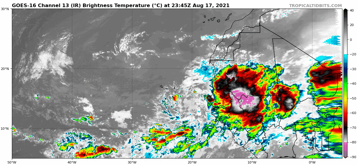
The convection over Africa tonight is quite impressive, if anything, this should help to moisten the MDR for future waves 
1 likes
-
Category5Kaiju
- Category 5
- Posts: 4335
- Joined: Thu Dec 24, 2020 12:45 pm
- Location: Seattle during the summer, Phoenix during the winter
Re: 2021 Indicators: SST's / SAL / MSLP / Shear / Steering / Instability / Sat Images
gatorcane wrote:The convection over Africa tonight is quite impressive, if anything, this should help to moisten the MDR for future waves
https://i.postimg.cc/fR4nGZrL/goes16-ir-eatl.gif
It probably will succumb to dry air, but boy is that wave giant. It's like Mega Mushroom Mario
4 likes
Unless explicitly stated, all information in my posts is based on my own opinions and observations. Tropical storms and hurricanes can be extremely dangerous. Refer to an accredited weather research agency or meteorologist if you need to make serious decisions regarding an approaching storm.
-
AtlanticWind

- S2K Supporter
- Posts: 1898
- Age: 67
- Joined: Sun Aug 08, 2004 9:57 pm
- Location: Plantation,Fla
Re: 2021 Indicators: SST's / SAL / MSLP / Shear / Steering / Instability / Sat Images
I think we are headed for 10 or more hurricanes this season with Grace and Henri likely bringing our
early season total to 3 . I would expect a very active September and especially October with a either
a la nina or cool neutral. I dont think the mdr sea surface temps being average or even slightly cooler is
going to matter much.
early season total to 3 . I would expect a very active September and especially October with a either
a la nina or cool neutral. I dont think the mdr sea surface temps being average or even slightly cooler is
going to matter much.
2 likes
Who is online
Users browsing this forum: No registered users and 398 guests