CPAC: LINDA - Post-Tropical
Moderator: S2k Moderators
-
MarioProtVI
- Category 5

- Posts: 1034
- Age: 24
- Joined: Sun Sep 29, 2019 7:33 pm
- Location: New Jersey
Re: EPAC: LINDA - Hurricane
She reminds me of Norman from 2018. Had weakened down to C1 after its near-C5 peak, then randomly reintensified back to C3 for a secondary peak.
0 likes
-
Yellow Evan

- Professional-Met

- Posts: 16241
- Age: 27
- Joined: Fri Jul 15, 2011 12:48 pm
- Location: Henderson, Nevada/Honolulu, HI
- Contact:

-
Kingarabian

- S2K Supporter

- Posts: 16367
- Joined: Sat Aug 08, 2009 3:06 am
- Location: Honolulu, Hawaii
Re: EPAC: LINDA - Hurricane
If it's going to keep this up, probably need to schedule a recon flight or two.
0 likes
RIP Kobe Bryant
-
Kingarabian
- S2K Supporter
- Posts: 16367
- Joined: Sat Aug 08, 2009 3:06 am
- Location: Honolulu, Hawaii
-
Kingarabian
- S2K Supporter
- Posts: 16367
- Joined: Sat Aug 08, 2009 3:06 am
- Location: Honolulu, Hawaii
Re: EPAC: LINDA - Hurricane
Models are also initializing this pretty badly now. This has been between 965-975mb and recently they keep initializing above 985mb.
0 likes
RIP Kobe Bryant
-
Yellow Evan
- Professional-Met
- Posts: 16241
- Age: 27
- Joined: Fri Jul 15, 2011 12:48 pm
- Location: Henderson, Nevada/Honolulu, HI
- Contact:
Re: EPAC: LINDA - Hurricane
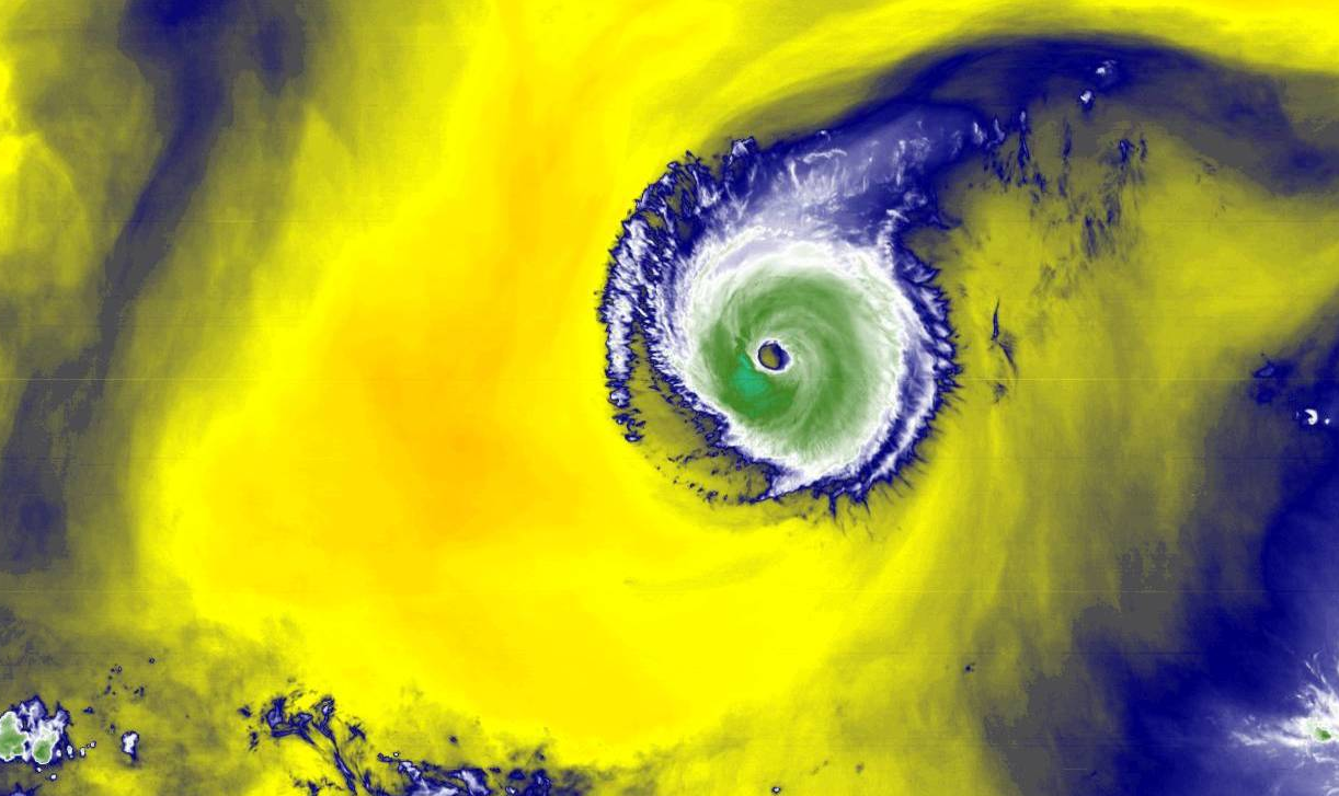
Kingarabian wrote::uarrow: Eye much more round now. This is clearly a major hurricane one again.
If it's going to keep this up, probably need to schedule a recon flight or two.
With Grace and Henri threatening land at high intensity down the road and the high probability this has no convection by the time it passes to the north, there is unlikely to be any Recon
4 likes
-
Yellow Evan
- Professional-Met
- Posts: 16241
- Age: 27
- Joined: Fri Jul 15, 2011 12:48 pm
- Location: Henderson, Nevada/Honolulu, HI
- Contact:

-
Kingarabian
- S2K Supporter
- Posts: 16367
- Joined: Sat Aug 08, 2009 3:06 am
- Location: Honolulu, Hawaii
Re: EPAC: LINDA - Hurricane
Open to the south 2 hours ago on this SSMIS pass:
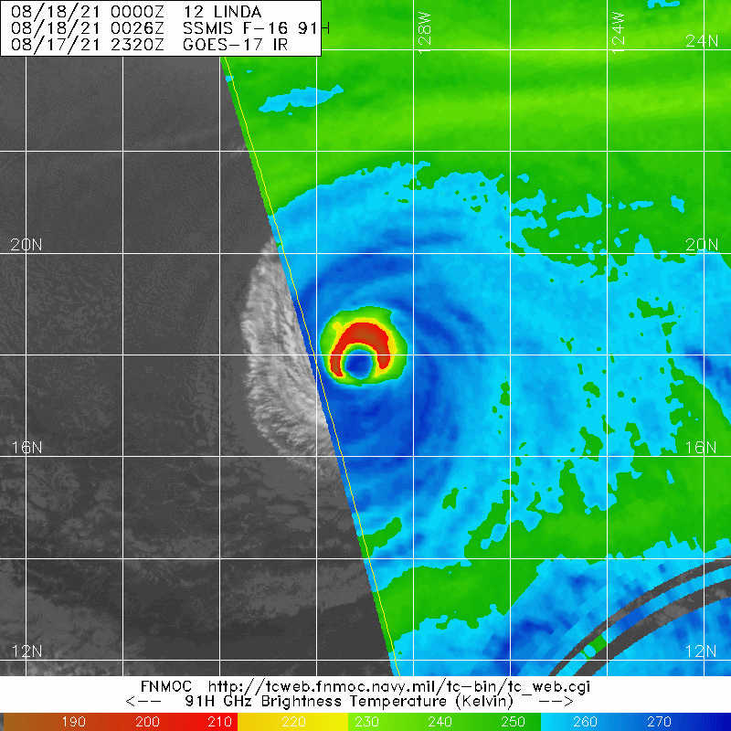
But considering that the coldest convection on the CDO is to the S/SW, more than likely it's closed now.
But considering that the coldest convection on the CDO is to the S/SW, more than likely it's closed now.
1 likes
RIP Kobe Bryant
-
Kingarabian
- S2K Supporter
- Posts: 16367
- Joined: Sat Aug 08, 2009 3:06 am
- Location: Honolulu, Hawaii
-
Sciencerocks
- Category 5
- Posts: 10186
- Age: 40
- Joined: Thu Jul 06, 2017 1:51 am

-
Kingarabian
- S2K Supporter
- Posts: 16367
- Joined: Sat Aug 08, 2009 3:06 am
- Location: Honolulu, Hawaii
Re: EPAC: LINDA - Hurricane
ADT CI now supports a major hurricane.
urrent Intensity Analysis
UW - CIMSS
ADVANCED DVORAK TECHNIQUE
ADT-Version 9.0
Tropical Cyclone Intensity Algorithm
----- Current Analysis -----
Date : 18 AUG 2021 Time : 015031 UTC
Lat : 17:51:00 N Lon : 129:14:24 W
CI# /Pressure/ Vmax
5.4 / 962.2mb/ 99.6kt
Final T# Adj T# Raw T#
5.4 5.3 5.3
Estimated radius of max. wind based on IR : 35 km
Center Temp : +17.9C Cloud Region Temp : -60.6C
Scene Type : LARGE EYE
Subtropical Adjustment : OFF
Extratropical Adjustment : OFF
Positioning Method : ARCHER POSITIONING
Ocean Basin : EAST PACIFIC
Dvorak CI > MSLP Conversion Used : CKZ Method
Tno/CI Rules : Constraint Limits : NO LIMIT
Weakening Flag : OFF
Rapid Dissipation Flag : OFF
0 likes
RIP Kobe Bryant
-
ScottNAtlanta

- Category 5
- Posts: 2535
- Joined: Sat May 25, 2013 3:11 pm
- Location: Atlanta, GA
Re: EPAC: LINDA - Hurricane
Does the water ahead stay above 26 degrees?
1 likes
The posts in this forum are NOT official forecast and should not be used as such. They are just the opinion of the poster and may or may not be backed by sound meteorological data. They are NOT endorsed by any professional institution or storm2k.org. For official information, please refer to the NHC and NWS products.
-
Kingarabian
- S2K Supporter
- Posts: 16367
- Joined: Sat Aug 08, 2009 3:06 am
- Location: Honolulu, Hawaii
Re: EPAC: LINDA - Hurricane
ScottNAtlanta wrote:Does the water ahead stay above 26 degrees?
Per GFS-SHIPS, in about 24-30 hours they should drop below 26 degrees. Between hours 36-96, the waters get as cold as 24 degrees. After that, they go back to 26C.
Other methods show better SST's than what the GFS-SHIPS show, but still they're all unanimous that the SST's will drop to at least 25C in 24 hours.
0 likes
RIP Kobe Bryant
-
Kingarabian
- S2K Supporter
- Posts: 16367
- Joined: Sat Aug 08, 2009 3:06 am
- Location: Honolulu, Hawaii
Re: EPAC: LINDA - Hurricane
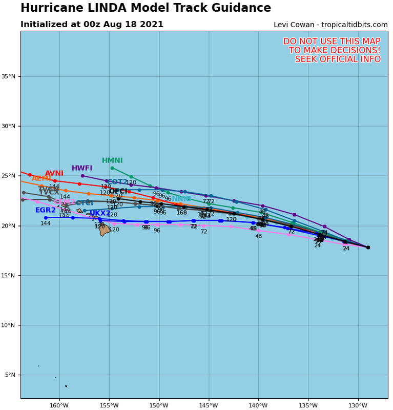
Based on its track forecast, MPI suggests this can maintain hurricane status so long it continues moving at a steady clip.
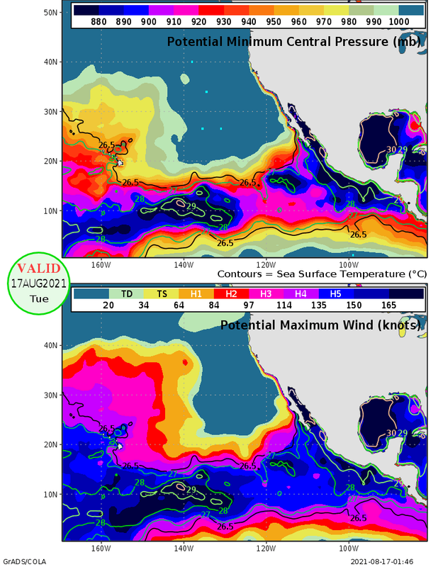
A Hawaii hit would be in 120-144 hours. SST's jump back up to 26c in about 96 hours. Very possible shear picks up quite a bit between hours 84/96. So might be a super close call here if the models do not go back to a re-curve scenario.
A Hawaii hit would be in 120-144 hours. SST's jump back up to 26c in about 96 hours. Very possible shear picks up quite a bit between hours 84/96. So might be a super close call here if the models do not go back to a re-curve scenario.
0 likes
RIP Kobe Bryant
-
cycloneye

- Admin

- Posts: 149514
- Age: 69
- Joined: Thu Oct 10, 2002 10:54 am
- Location: San Juan, Puerto Rico
Re: EPAC: LINDA - Hurricane
[Div][
BULLETIN
Hurricane Linda Advisory Number 32
NWS National Hurricane Center Miami FL EP122021
500 PM HST Tue Aug 17 2021
...LINDA INTENSIFIES BACK INTO A CATEGORY 2 HURRICANE...
SUMMARY OF 500 PM HST...0300 UTC...INFORMATION
----------------------------------------------
LOCATION...17.9N 129.5W
ABOUT 1315 MI...2115 KM WSW OF THE SOUTHERN TIP OF BAJA CALIFORNIA
MAXIMUM SUSTAINED WINDS...105 MPH...165 KM/H
PRESENT MOVEMENT...W OR 280 DEGREES AT 12 MPH...19 KM/H
MINIMUM CENTRAL PRESSURE...975 MB...28.80 INCHES
WATCHES AND WARNINGS
--------------------
There are no coastal watches or warnings in effect.
DISCUSSION AND OUTLOOK
----------------------
At 500 PM HST (0300 UTC), the center of Hurricane Linda was located
near latitude 17.9 North, longitude 129.5 West. Linda is moving
toward the west near 12 mph (19 km/h). A turn towards the
west-northwest is expected later tonight, with that motion
forecast to continue through the remainder of the week.
Maximum sustained winds have increased to near 105 mph (165 km/h)
with higher gusts. Little change strength is expected tonight, but
a slow weakening trend is forecast to begin by the end of tomorrow.
Hurricane-force winds extend outward up to 30 miles (45 km) from the
center and tropical-storm-force winds extend outward up to 90 miles
(150 km).
The estimated minimum central pressure is 975 mb (28.80 inches).
HAZARDS AFFECTING LAND
----------------------
None.
NEXT ADVISORY
-------------
Next complete advisory at 1100 PM HST.
$$
Forecaster Papin/Brown
/Div]
1 likes
Visit the Caribbean-Central America Weather Thread where you can find at first post web cams,radars
and observations from Caribbean basin members Click Here
and observations from Caribbean basin members Click Here
-
cycloneye
- Admin
- Posts: 149514
- Age: 69
- Joined: Thu Oct 10, 2002 10:54 am
- Location: San Juan, Puerto Rico
Re: EPAC: LINDA - Hurricane
Hurricane Linda Discussion Number 32
NWS National Hurricane Center Miami FL EP122021
500 PM HST Tue Aug 17 2021
Linda has made a bit of a comeback over the last 6-12 hours. While
the eye continues to remain clear and warm, the eyewall convection
has been gradually cooling over the course of the day, with a
thickening ring of -60 to -65 C cloud top temperatures occasionally
surrounding the eye. This has led to an increase in the most recent
subjective Dvorak intensity estimates which at 0000 UTC were
T5.5/102 kt from SAB and T5.0/90 kt from TAFB. The latest objective
UW-CIMSS ADT estimate is up to T5.3/97 kt though the most recent
SATCON estimate was only 79 kt. Taking a blend of these data yields
an estimated intensity of 90 kt for this advisory.
Linda is starting to gain some latitude, with the estimated motion
now at 280/10 kt. The track guidance philosophy remains the same,
with a mid-level ridge well-established across the North Pacific
expected to keep Linda moving on a west-northwestward track thorough
the forecast period. Once again, the guidance has shifted a bit
faster over the forecast period, and the latest NHC track forecast
has also been nudged a little faster. Based on the latest forecast,
Linda should be crossing into the Central Pacific in about 48 hours,
and is expected to pass by to the north of the Hawaiian Islands as a
post-tropical gale late in the weekend.
Linda's recent increase in intensity could be related to the cyclone
moving over a small finger of warmer sea-surface temperatures (SSTs)
currently. The storm has continued to maintain its stable annular
structure, and little change in strength is expected during the next
12 h. However, SSTs will soon begin to decrease once again and
should drop below 25 C beyond 24 hours. While the deep-layer
vertical wind shear diagnosed by SHIPS is expected to remain low for
the next 72 hours, a bit more westerly mid-level shear could begin
to undercut the outflow layer in 24-36 hours. For these reasons,
Linda should begin a more pronounced weakening trend after 24 hours,
with the tropical cyclone forecast to finally drop below hurricane
intensity Thursday Night. The latest NHC intensity forecast remains
on the high side of the guidance for the first 24 hours, but then is
brought down to the guidance mean afterwards, in best agreement with
the HFIP Corrected Consensus Approach (HCCA) guidance. While SSTs do
begin to increase again after 72 hours, an increase in southwesterly
shear is expected to prevent organized convection from redeveloping
near the center, and Linda is forecast to become a post-tropical
gale by that time.
FORECAST POSITIONS AND MAX WINDS
INIT 18/0300Z 17.9N 129.5W 90 KT 105 MPH
12H 18/1200Z 18.4N 131.2W 90 KT 105 MPH
24H 19/0000Z 19.2N 133.9W 80 KT 90 MPH
36H 19/1200Z 20.0N 136.9W 70 KT 80 MPH
48H 20/0000Z 20.7N 140.0W 60 KT 70 MPH
60H 20/1200Z 21.3N 142.9W 50 KT 60 MPH
72H 21/0000Z 21.6N 145.6W 40 KT 45 MPH...POST-TROPICAL
96H 22/0000Z 22.2N 150.0W 35 KT 40 MPH...POST-TROPICAL
120H 23/0000Z 22.7N 154.2W 35 KT 40 MPH...POST-TROPICAL
$$
Forecaster Papin/Brown
0 likes
Visit the Caribbean-Central America Weather Thread where you can find at first post web cams,radars
and observations from Caribbean basin members Click Here
and observations from Caribbean basin members Click Here
-
Yellow Evan
- Professional-Met
- Posts: 16241
- Age: 27
- Joined: Fri Jul 15, 2011 12:48 pm
- Location: Henderson, Nevada/Honolulu, HI
- Contact:
-
Kingarabian
- S2K Supporter
- Posts: 16367
- Joined: Sat Aug 08, 2009 3:06 am
- Location: Honolulu, Hawaii
-
Kingarabian
- S2K Supporter
- Posts: 16367
- Joined: Sat Aug 08, 2009 3:06 am
- Location: Honolulu, Hawaii

-
ScottNAtlanta
- Category 5
- Posts: 2535
- Joined: Sat May 25, 2013 3:11 pm
- Location: Atlanta, GA
Re: EPAC: LINDA - Hurricane
Hawaii is lucky there are cooler waters to the east. If they were not there hurricanes would be a frequent problem every year
1 likes
The posts in this forum are NOT official forecast and should not be used as such. They are just the opinion of the poster and may or may not be backed by sound meteorological data. They are NOT endorsed by any professional institution or storm2k.org. For official information, please refer to the NHC and NWS products.
Who is online
Users browsing this forum: No registered users and 30 guests