ATL: GRACE - Models
Moderator: S2k Moderators

Re: ATL: GRACE - Models
06z GFS has two borderline cat 2 landfalls in Mexico. Considering that at least last year GFS often slightly underestimated storm intensity, the recent trend makes me quite confident regarding Grace making landfall at Yucatan as a hurricane. Meanwhile HWRF still seems to struggle with Grace for no apparent reason, has a 1008 mbar TD/TS at +27 hrs even though it passes Jamaica to the north as well. I guess the models will come to a better agreement once Grace has passed Jamaica.
0 likes
Re: ATL: GRACE - Models
Both HWRF and HMON have a Yucatan landfall as a high-end TS instead of a cat 2 as GFS shows. However, just before the 2nd landfall in Mexico both show a strong hurricane: 946 mbar and 116 kts for HWRF (cat 4) and 967 mbar and 96 kts for HMON (borderline cat 3).
HWRF

HMON

HWRF
HMON
3 likes
Re: ATL: GRACE - Models
HMON now also goes for a stronger system at Yucatan, but afterwards it takes a bit longer to intensify Grace again so it has 2 Cat 2 landfalls (979mb/92kt and 976mb/86kt). Same goes for HWRF with a high-end cat 2 Yucatan landfall (970mb/95kt) followed by an insane cat 4 landfall later on (948mb/114kt). If the latter were to happen it would only be the 3rd Cat 4+ Mexico landfall in August (the previous ones are Dean in 2005 and #2 in 1880). While this is a bit extreme, I do want to note that f.e. GFS also shows 2 Cat 1 landfalls, so even though cat 4 is a bit on the extreme end I think a double hurricane strength landfall is quite probable.
1 likes
Re: ATL: GRACE - Models
Looks like ICON is also caving towards the stronger solutions for Grace, look at this 4 run trend.

1 likes
-
cheezyWXguy

- Category 5

- Posts: 6282
- Joined: Mon Feb 13, 2006 12:29 am
- Location: Dallas, TX
Re: ATL: GRACE - Models
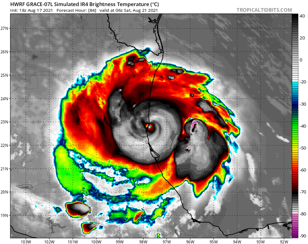
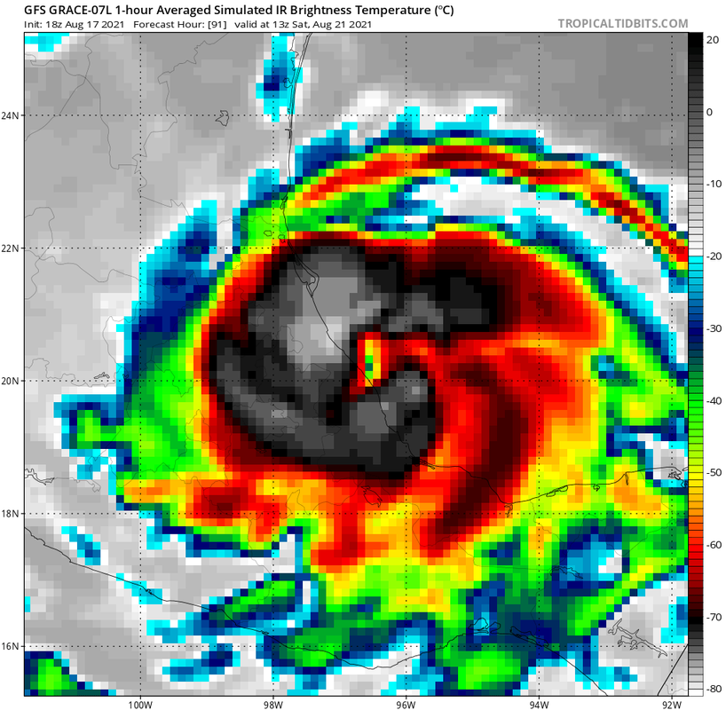
18z gfs rolling. And it’s quite a bit stronger. 982mb at hour 30 before reaching the Yucatán. Resolution of the model seems to be getting in the way though, because the simulated IR presentation at that time looks like a major
0 likes
-
Iceresistance

- Category 5
- Posts: 9598
- Age: 22
- Joined: Sat Oct 10, 2020 9:45 am
- Location: Tecumseh, OK/Norman, OK
Re: ATL: GRACE - Models
18z GFS Peaks at 970 MB over the BoC

1 likes
Bill 2015 & Beta 2020
Winter 2020-2021
All observations are in Tecumseh, OK unless otherwise noted.
Winter posts are focused mainly for Oklahoma & Texas.
Take any of my forecasts with a grain of salt, refer to the NWS, SPC, and NHC for official information
Never say Never with weather! Because ANYTHING is possible!
Winter 2020-2021
All observations are in Tecumseh, OK unless otherwise noted.
Winter posts are focused mainly for Oklahoma & Texas.
Take any of my forecasts with a grain of salt, refer to the NWS, SPC, and NHC for official information
Never say Never with weather! Because ANYTHING is possible!

Re: ATL: GRACE - Models
Man, the GFS has Grace moving at super speed west. I really hope that ridge holds firm, but concerned about her impacts in Mexico.
1 likes
Personal Forecast Disclaimer:
The posts in this forum are NOT official forecast and should not be used as such. They are just the opinion of the poster and may or may not be backed by sound meteorological data. They are NOT endorsed by any professional institution or storm2k.org. For official information, please refer to the NHC and NWS products.
The posts in this forum are NOT official forecast and should not be used as such. They are just the opinion of the poster and may or may not be backed by sound meteorological data. They are NOT endorsed by any professional institution or storm2k.org. For official information, please refer to the NHC and NWS products.

Re: ATL: GRACE - Models
Strangely, the HWRF has been trending weaker with Grace in the WCar. Maybe it’s not initializing some of the structure right, or thinking the PVS will be more of an impact.
0 likes
Irene '11 Sandy '12 Hermine '16 5/15/2018 Derecho Fay '20 Isaias '20 Elsa '21 Henri '21 Ida '21
I am only a meteorology enthusiast who knows a decent amount about tropical cyclones. Look to the professional mets, the NHC, or your local weather office for the best information.
I am only a meteorology enthusiast who knows a decent amount about tropical cyclones. Look to the professional mets, the NHC, or your local weather office for the best information.
-
tolakram
- Admin

- Posts: 20186
- Age: 62
- Joined: Sun Aug 27, 2006 8:23 pm
- Location: Florence, KY (name is Mark)
Re: ATL: GRACE - Models
18z Euro

1 likes
M a r k
- - - - -
Join us in chat: Storm2K Chatroom Invite. Android and IOS apps also available.
The posts in this forum are NOT official forecasts and should not be used as such. Posts are NOT endorsed by any professional institution or STORM2K.org. For official information and forecasts, please refer to NHC and NWS products.

Re: ATL: GRACE - Models
GFS has 991 MB for the 1st landfall on the Yucatan and 977 MB for the 2nd Mexico landfall.
0 likes
-
ElectricStorm

- Category 5
- Posts: 5148
- Age: 25
- Joined: Tue Aug 13, 2019 11:23 pm
- Location: Norman, OK
Re: ATL: GRACE - Models
Both HMON and HWRF appear to have decent initialization and both have pressures in the 970's at landfall in the Yucatan
0 likes
B.S Meteorology, University of Oklahoma '25
Please refer to the NHC, NWS, or SPC for official information.
Please refer to the NHC, NWS, or SPC for official information.
-
Kingarabian

- S2K Supporter

- Posts: 16373
- Joined: Sat Aug 08, 2009 3:06 am
- Location: Honolulu, Hawaii
Re: ATL: GRACE - Models
Grace might be with us for a while.

This is not just the Euro showing this. Majority of the models showing its remnant moving over into the EPAC and redeveloping.
This is not just the Euro showing this. Majority of the models showing its remnant moving over into the EPAC and redeveloping.
0 likes
RIP Kobe Bryant
Re: ATL: GRACE - Models
06z GFS down to 969 mbar before landfall, strongest GFS operational run for Grace that I've seen so far. Henri also deepens a lot (down to 965 mbar) later in the run btw.
0 likes


Re: ATL: GRACE - Models
Kingarabian wrote:Grace might be with us for a while.
https://i.imgur.com/lXSxlbw.gif
This is not just the Euro showing this. Majority of the models showing its remnant moving over into the EPAC and redeveloping.
This could produce some very high ACE values if this were to hold true! On another note, If it were to redevelop and some how keep it's core through MEX in the EPAC how would the ACE values work would they be split between the basins, tried looking into Otto back into 2016 and might have missed that part, anyways a crossover would be very interesting. Although IMO I would think it would just be to disorganized after getting through and would redevelop similar to how Hurricane Danielle preceded Hurricane Hermine.
0 likes
Once I see the REDS and GREENS Converge on a Base Velocity. ... I'm There!!
This is NOT an Official Forecast....Just my Opinion. For official information, please refer to the NHC and NWS products.
HIGHLIGHTS : '13 El Reno Tornado : 2013 Storm Chaser Tour, Joaquin; SC flood event, Matthew '16, Lowcountry Snow storm Jan '18
This is NOT an Official Forecast....Just my Opinion. For official information, please refer to the NHC and NWS products.
HIGHLIGHTS : '13 El Reno Tornado : 2013 Storm Chaser Tour, Joaquin; SC flood event, Matthew '16, Lowcountry Snow storm Jan '18
Re: ATL: GRACE - Models
There's still a big uncertainty regarding the intensity at the Yucatan landfall. 06z HWRF is near the lower end of the intensity spectrum with a cat 1 landfall (76 kts), but 06z HMON shows a cat 3 (99 kts) landfall. I guess the current recon mission will be an important indicator. HWRF doesn't get Grace to hurricane strength until +21 hours (03z, Thursday), while HMON already has it near hurricane strength right now and reaches it later today.
0 likes
Re: ATL: GRACE - Models
In 06z HWRF, Grace's cyclonic vorticity is pretty much not affected by Yucatan just like land isn't even there. Yucatan does halt intensification, but in this run Grace is a hurricane pretty much the second she jumps back above water.
0 likes
Re: ATL: GRACE - Models
6z HWRF continues to show a low 950s Cat 3 at landfall in the BoC, but it also shows a slightly further north track that reduces the amount of time Grace spends over the Yucatán from ~18 hours to a little under 12 hours. That could have significant implications on how strong it’ll be in the BoC and how much of a core it’ll have left.
0 likes
Irene '11 Sandy '12 Hermine '16 5/15/2018 Derecho Fay '20 Isaias '20 Elsa '21 Henri '21 Ida '21
I am only a meteorology enthusiast who knows a decent amount about tropical cyclones. Look to the professional mets, the NHC, or your local weather office for the best information.
I am only a meteorology enthusiast who knows a decent amount about tropical cyclones. Look to the professional mets, the NHC, or your local weather office for the best information.
Re: ATL: GRACE - Models
Kingarabian wrote:Grace might be with us for a while.
https://i.imgur.com/lXSxlbw.gif
This is not just the Euro showing this. Majority of the models showing its remnant moving over into the EPAC and redeveloping.
WOW. Would this calculate into the Atlantic's ACE season or start with the Pacific once it crosses over? Seems like it would contribute to both ACE's.
0 likes
Personal Forecast Disclaimer:
The posts in this forum are NOT official forecast and should not be used as such. They are just the opinion of the poster and may or may not be backed by sound meteorological data. They are NOT endorsed by any professional institution or storm2k.org. For official information, please refer to the NHC and NWS products.
The posts in this forum are NOT official forecast and should not be used as such. They are just the opinion of the poster and may or may not be backed by sound meteorological data. They are NOT endorsed by any professional institution or storm2k.org. For official information, please refer to the NHC and NWS products.
Re: ATL: GRACE - Models
SoupBone wrote:Kingarabian wrote:Grace might be with us for a while.
https://i.imgur.com/lXSxlbw.gif
This is not just the Euro showing this. Majority of the models showing its remnant moving over into the EPAC and redeveloping.
WOW. Would this calculate into the Atlantic's ACE season or start with the Pacific once it crosses over? Seems like it would contribute to both ACE's.
Would depend on how disorganized Grace gets. It could form a completely new storm in the EPAC in some circumstances
0 likes
Once I see the REDS and GREENS Converge on a Base Velocity. ... I'm There!!
This is NOT an Official Forecast....Just my Opinion. For official information, please refer to the NHC and NWS products.
HIGHLIGHTS : '13 El Reno Tornado : 2013 Storm Chaser Tour, Joaquin; SC flood event, Matthew '16, Lowcountry Snow storm Jan '18
This is NOT an Official Forecast....Just my Opinion. For official information, please refer to the NHC and NWS products.
HIGHLIGHTS : '13 El Reno Tornado : 2013 Storm Chaser Tour, Joaquin; SC flood event, Matthew '16, Lowcountry Snow storm Jan '18
Who is online
Users browsing this forum: No registered users and 27 guests