CPAC: LINDA - Post-Tropical
Moderator: S2k Moderators
-
Kingarabian

- S2K Supporter

- Posts: 16367
- Joined: Sat Aug 08, 2009 3:06 am
- Location: Honolulu, Hawaii
Re: EPAC: LINDA - Hurricane
According to studies, annular hurricanes need at least 25.4C waters to maintain. In about 4 hours or so Linda will be going over sub 25C waters for the next 36-48 hours. It will be extremely shallow by the time it reaches 25C+ waters again. Wondering if it keeps its annular skeleton if it will amp up again before it gets blasted by the Hawaiian shear.
0 likes
RIP Kobe Bryant
-
Kingarabian
- S2K Supporter
- Posts: 16367
- Joined: Sat Aug 08, 2009 3:06 am
- Location: Honolulu, Hawaii
Re: EPAC: LINDA - Hurricane
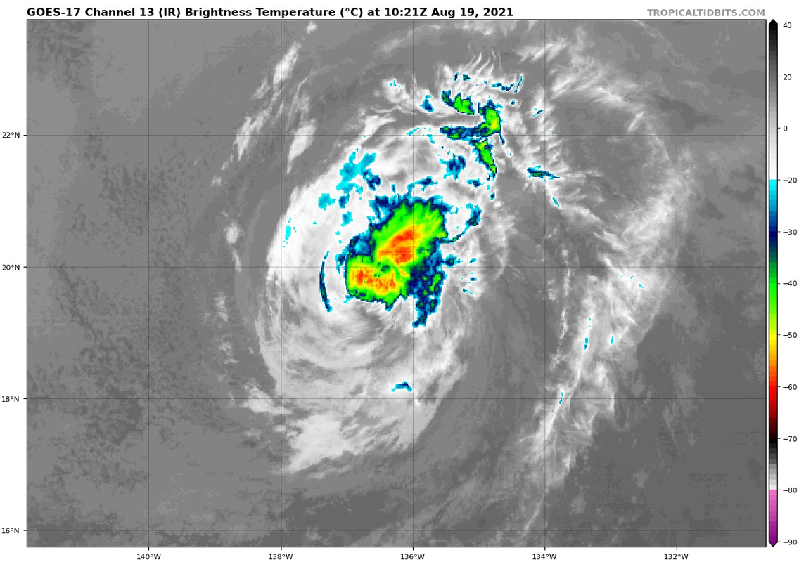
Recon found 95kt winds in Douglas last year with an IR presentation that looked like this:

Linda arguably looks better:

I think the NHC should weaken this very slowly until proven otherwise.
Linda arguably looks better:
I think the NHC should weaken this very slowly until proven otherwise.
2 likes
RIP Kobe Bryant
-
Kingarabian
- S2K Supporter
- Posts: 16367
- Joined: Sat Aug 08, 2009 3:06 am
- Location: Honolulu, Hawaii

-
Yellow Evan

- Professional-Met

- Posts: 16241
- Age: 27
- Joined: Fri Jul 15, 2011 12:48 pm
- Location: Henderson, Nevada/Honolulu, HI
- Contact:
Re: EPAC: LINDA - Hurricane
TXPZ23 KNES 190004
TCSENP
A. 12E (LINDA)
B. 18/2330Z
C. 19.2N
D. 133.8W
E. ONE/GOES-W
F. T4.5/5.0
G. IR/EIR
H. REMARKS...OW EYE SURROUNDED BY MG AND EMBEDDED IN DG RESULTS IN A
DT OF 4.5. THE MET IS ALSO 4.5 BASED ON A WEAKENING TREND OVER THE PAST
24 HOURS. THE PT IS 4.0. FT IS BASED ON DT.
I. ADDL POSITIONS
NIL
...COVERDALE
0 likes
-
Kingarabian
- S2K Supporter
- Posts: 16367
- Joined: Sat Aug 08, 2009 3:06 am
- Location: Honolulu, Hawaii
Re: EPAC: LINDA - Hurricane
Linda is 6 hours ahead of the NHCs next forecast point.
0 likes
RIP Kobe Bryant
-
Sciencerocks
- Category 5

- Posts: 10186
- Age: 40
- Joined: Thu Jul 06, 2017 1:51 am

-
cycloneye

- Admin

- Posts: 149514
- Age: 69
- Joined: Thu Oct 10, 2002 10:54 am
- Location: San Juan, Puerto Rico
Re: EPAC: LINDA - Hurricane
Hurricane Linda Discussion Number 35
NWS National Hurricane Center Miami FL EP122021
1100 AM HST Wed Aug 18 2021
Since the time of the previous advisory, satellite images show that
Linda's cloud tops have warmed and are less prevalent on its west
side. Visible imagery has also shown an increase in the low-level
cloud cover inside the eye, though Linda still displays a fairly
well-defined eye in infrared imagery. Dvorak T-numbers from TAFB and
SAB have decreased, and the initial intensity has been lowered to 85
kt for this advisory.
Linda is currently over SSTs near 26 C, but SSTs along the path of
the cyclone will decrease to below 25 C in about 6 hours, then
remain in the 24-25 C range between 6 to 48 hours. Vertical wind
shear will remain low through 48 h, then steadily increase during
the day 3 to 5 period as Linda approaches a potent upper-level
trough located to the northwest of Oahu. Perhaps even more
detrimental than the gradually increasing wind shear is the dry
airmass that Linda is embedded in, with environmental mid-level
relative humidity values of less than 40 percent. Mid-level moisture
is forecast to decrease further over the next 48 hours. A
combination of these environmental factors will ultimately lead to
the loss of deep convection, and Linda is forecast to become a
post-tropical gale by Saturday. Although the intensity forecast
reasoning has not changed appreciably, a slightly faster weakening
rate is forecast through the first 36 hours. However, the new NHC
intensity forecast still lies at the high end of the guidance during
that time. Beyond 36 h, little change has been made to the previous
forecast.
The initial motion is 285/12 kt. A well-established subtropical
ridge should steer Linda in a westward to west-northwestward fashion
during the next 5 days. There is essentially no change to the
forecast track through 72 hours. Thereafter, a slight southward
nudge was made, but still lies just to the north of the TVCE and
HCCA consensus aids. Linda is forecast to cross into the Central
Pacific in about 30 h and is expected to pass to the north of the
Hawaiian Islands as a post-tropical gale late Sunday into Monday.
FORECAST POSITIONS AND MAX WINDS
INIT 18/2100Z 18.7N 133.2W 85 KT 100 MPH
12H 19/0600Z 19.3N 135.3W 75 KT 85 MPH
24H 19/1800Z 20.0N 138.3W 65 KT 75 MPH
36H 20/0600Z 20.6N 141.4W 55 KT 65 MPH
48H 20/1800Z 21.0N 144.2W 50 KT 60 MPH
60H 21/0600Z 21.3N 146.7W 45 KT 50 MPH
72H 21/1800Z 21.8N 149.0W 40 KT 45 MPH...POST-TROPICAL
96H 22/1800Z 22.7N 153.5W 35 KT 40 MPH...POST-TROPICAL
120H 23/1800Z 23.4N 158.5W 30 KT 35 MPH...POST-TROPICAL
$$
Forecaster Hagen/Papin/Cangialosi
0 likes
Visit the Caribbean-Central America Weather Thread where you can find at first post web cams,radars
and observations from Caribbean basin members Click Here
and observations from Caribbean basin members Click Here
-
Kingarabian
- S2K Supporter
- Posts: 16367
- Joined: Sat Aug 08, 2009 3:06 am
- Location: Honolulu, Hawaii
Re: EPAC: LINDA - Hurricane
Doing well so far despite being over sub 25C waters. The luxury of no shear.

0 likes
RIP Kobe Bryant
-
Kingarabian
- S2K Supporter
- Posts: 16367
- Joined: Sat Aug 08, 2009 3:06 am
- Location: Honolulu, Hawaii
Re: EPAC: LINDA - Hurricane
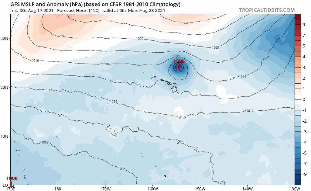
00z GEFS more than half the members show some sort of Hawaii impacts.

00z GFS shifted closer to Hawaii. 00z UKMET shifted well north of Hawaii. 00z ICON also shifted north. 00z CMC still the most south and continues to show Hawaii impacts.
00z GFS shifted closer to Hawaii. 00z UKMET shifted well north of Hawaii. 00z ICON also shifted north. 00z CMC still the most south and continues to show Hawaii impacts.
0 likes
RIP Kobe Bryant
-
cycloneye
- Admin
- Posts: 149514
- Age: 69
- Joined: Thu Oct 10, 2002 10:54 am
- Location: San Juan, Puerto Rico
Re: EPAC: LINDA - Hurricane
Hurricane Linda Discussion Number 37
NWS National Hurricane Center Miami FL EP122021
1100 PM HST Wed Aug 18 2021
Linda is slowly losing convective organization with the eye now
open in the western quadrant in both infrared and passive microwave
satellite imagery. However, the upper-level cirrus outflow remains
quite impressive and nearly symmetrical. The initial intensity has
been lowered to 75 kt based a blend of Dvorak satellite current
intensity (CI) estimates of 65 kt from TAFB and 77 kt from SAB, and
objective satellite intensity estimates of T4.3/72 kt and 77 kt
from UW-CIMSS ADT and SATCON, respectively.
The initial motion estimate remains west-northwestward, or 285/15
kt. This general motion is forecast by the global and regional
models to continue throughout the forecast period as Linda moves
along the southern periphery of a strong deep-layer ridge anchored
across most of the eastern and central Pacific basins. The new NHC
forecast track is essentially just an update of the previous
advisory track and lies close to the middle of the tightly clustered
simple- and corrected-consensus track models. On the current track,
Linda should cross into the Central Pacific basin in about 18 hours.
Linda is located over 24-25 C sea-surface temperatures (SST), which
are expected to remain steady for the next 48-60 hours, during
which the vertical wind shear is expected to remain low at around
5 kt. The favorable shear should help to offset the unfavorable
SSTs beneath the cyclone, resulting in a slower-than-normal rate
of weakening. Thereafter, SSTs are forecast to gradually increase
above 26 deg C on days 4 and 5. However, the vertical wind shear is
forecast to increase from the southwest in excess of 30 kt, causing
even greater weakening. The new official intensity forecast is
similar to the previous advisory and calls for Linda to steadily
weaken through the forecast period and degenerate into a
post-tropical gale by 60 hours, which is in line with the trend in
the IVCN and HCCA intensity consensus models.
FORECAST POSITIONS AND MAX WINDS
INIT 19/0900Z 19.7N 136.2W 75 KT 85 MPH
12H 19/1800Z 20.2N 138.5W 60 KT 70 MPH
24H 20/0600Z 20.7N 141.6W 50 KT 60 MPH
36H 20/1800Z 21.0N 144.5W 45 KT 50 MPH
48H 21/0600Z 21.3N 147.0W 40 KT 45 MPH
60H 21/1800Z 21.7N 149.4W 40 KT 45 MPH...POST-TROPICAL
72H 22/0600Z 22.1N 151.6W 40 KT 45 MPH...POST-TROPICAL
96H 23/0600Z 23.0N 156.2W 35 KT 40 MPH...POST-TROPICAL
120H 24/0600Z 23.6N 161.4W 25 KT 30 MPH...POST-TROP/REMNT LOW
$$
Forecaster Stewart
0 likes
Visit the Caribbean-Central America Weather Thread where you can find at first post web cams,radars
and observations from Caribbean basin members Click Here
and observations from Caribbean basin members Click Here
-
Kingarabian
- S2K Supporter
- Posts: 16367
- Joined: Sat Aug 08, 2009 3:06 am
- Location: Honolulu, Hawaii
Re: EPAC: LINDA - Hurricane
GFS shifting closer and closer to Hawaii with each run:
00z Euro:
 Getting close to being devoid of convection but the models and the NHC think it'll still pack 40kt winds.
00z Euro:
0 likes
RIP Kobe Bryant
-
Shell Mound
- Category 5
- Posts: 2432
- Age: 33
- Joined: Thu Sep 07, 2017 3:39 pm
- Location: St. Petersburg, FL → Scandinavia
Re: EPAC: LINDA - Hurricane
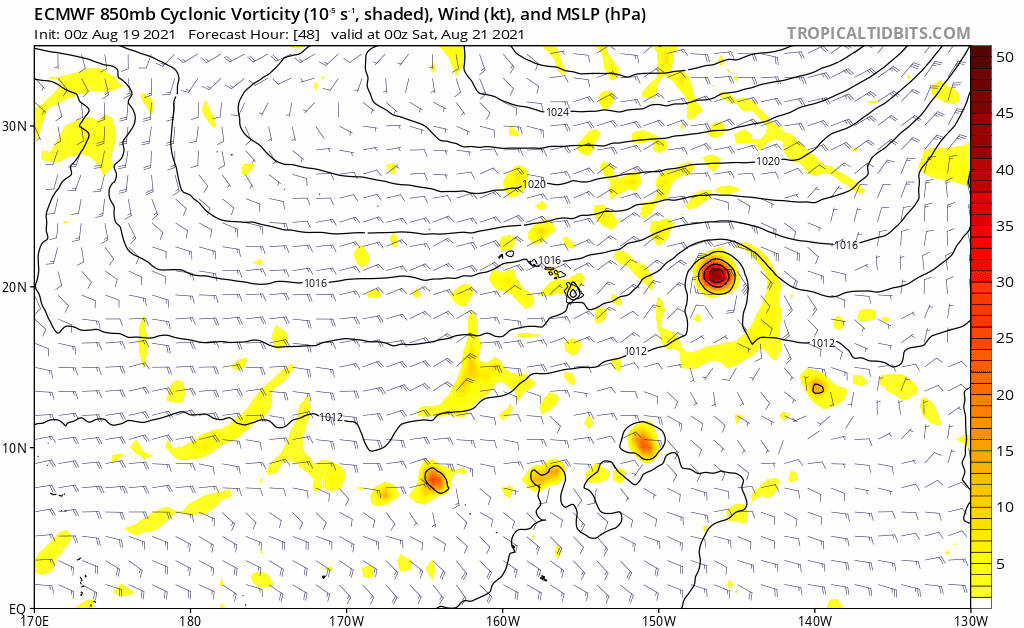
Kingarabian wrote:GFS shifting closer and closer to Hawaii with each run:
https://i.postimg.cc/jj9JrSCR/gfs-mslpa-cpac-fh96-trend.gif
00z Euro:
https://i.postimg.cc/nLsCTf2g/ecmwf-uv850-vort-cpac-fh48-120.gif
https://i.postimg.cc/Jh825RR4/image.png
As usual, the closer it gets, the weaker it ends up being. In this case I doubt that anything will be left of Linda by the time of its interaction with Hawaii.
1 likes
CVW / MiamiensisWx / Shell Mound
The posts in this forum are NOT official forecasts and should not be used as such. They are just the opinion of the poster and may or may not be backed by sound meteorological data. They are NOT endorsed by any professional institution or STORM2K. For official information, please refer to products from the NHC and NWS.
-
wxman57

- Moderator-Pro Met

- Posts: 23175
- Age: 68
- Joined: Sat Jun 21, 2003 8:06 pm
- Location: Houston, TX (southwest)
Re: EPAC: LINDA - Hurricane
Convection dissipating. Doubt it's anywhere near hurricane strength now. Very odd NHC classification of "post-tropical" with 40 kt winds as it nears Hawaii. May be more of a remnant low with 25-30 kts given the cooler water in its path. Good news for Hawaii. We have a number of clients there.
1 likes

Re: EPAC: LINDA - Hurricane
She had a good run. Just like the other major this year, Linda far exceeded all expectations and was quite the meteorological eye candy for such a long time. With a La Niña continuing to develop, I’m doubtful we’ll get any long-tracker close to this during the rest of the season.
1 likes
Irene '11 Sandy '12 Hermine '16 5/15/2018 Derecho Fay '20 Isaias '20 Elsa '21 Henri '21 Ida '21
I am only a meteorology enthusiast who knows a decent amount about tropical cyclones. Look to the professional mets, the NHC, or your local weather office for the best information.
I am only a meteorology enthusiast who knows a decent amount about tropical cyclones. Look to the professional mets, the NHC, or your local weather office for the best information.

Re: EPAC: LINDA - Hurricane
Thank you Linda for putting up a good satellite show during the past few days.
1 likes
-
Sciencerocks
- Category 5
- Posts: 10186
- Age: 40
- Joined: Thu Jul 06, 2017 1:51 am

-
Iceresistance

- Category 5
- Posts: 9592
- Age: 22
- Joined: Sat Oct 10, 2020 9:45 am
- Location: Tecumseh, OK/Norman, OK
Re: EPAC: LINDA - Tropical Storm
Linda is no longer a Hurricane . . .
...LINDA QUICKLY WEAKENING ...
5:00 AM HST Thu Aug 19
Location: 19.9°N 137.6°W
Moving: W at 16 mph
Min pressure: 996 mb
Max sustained: 70 mph
5:00 AM HST Thu Aug 19
Location: 19.9°N 137.6°W
Moving: W at 16 mph
Min pressure: 996 mb
Max sustained: 70 mph
0 likes
Bill 2015 & Beta 2020
Winter 2020-2021
All observations are in Tecumseh, OK unless otherwise noted.
Winter posts are focused mainly for Oklahoma & Texas.
Take any of my forecasts with a grain of salt, refer to the NWS, SPC, and NHC for official information
Never say Never with weather! Because ANYTHING is possible!
Winter 2020-2021
All observations are in Tecumseh, OK unless otherwise noted.
Winter posts are focused mainly for Oklahoma & Texas.
Take any of my forecasts with a grain of salt, refer to the NWS, SPC, and NHC for official information
Never say Never with weather! Because ANYTHING is possible!
-
cheezyWXguy

- Category 5
- Posts: 6282
- Joined: Mon Feb 13, 2006 12:29 am
- Location: Dallas, TX
Re: EPAC: LINDA - Hurricane
Sciencerocks wrote:https://imagizer.imageshack.com/img922/7801/BtQdcj.gif
I think Linda might not be annular anymore guys
4 likes
-
TallyTracker
- Category 2

- Posts: 787
- Joined: Thu Oct 11, 2018 2:46 pm
Re: EPAC: LINDA - Tropical Srorm
I’m starting to wonder if there will be enough Linda left to give the folks in Honolulu a few advisories! It vaporized literally overnight!
0 likes
Fran '96, Georges '98, Gordon '00, Gabrielle '01, Charley '04, Frances '04, Jeanne '04, Barry '07, Fay '08, Debby '12, Matthew '16, Emily '17, Irma '17, Michael ‘18, Elsa ‘21, Fred ‘21, Mindy ‘21, Nicole ‘22, Idalia ‘23, Debby ‘24, Helene ‘24
-
Kingarabian
- S2K Supporter
- Posts: 16367
- Joined: Sat Aug 08, 2009 3:06 am
- Location: Honolulu, Hawaii
Re: EPAC: LINDA - Tropical Srorm
TallyTracker wrote:I’m starting to wonder if there will be enough Linda left to give the folks in Honolulu a few advisories! It vaporized literally overnight!
The skeleton of Linda is still there though. So even if convection fades completely, once it reaches warmer waters near 145W it'll start to refire. We saw a sort of similar situation with Douglas 2020 although Lindas case is much more extreme. The issue for it is as the waters warm once again, shear picks up.
0 likes
RIP Kobe Bryant
Who is online
Users browsing this forum: No registered users and 26 guests