Euro

Moderator: S2k Moderators


tolakram wrote:GFS invents a new storm. Not sure I believe this, but the EUro has an echo as well, just off the east coast instead.
https://i.imgur.com/q5JSz4V.gif

gatorcane wrote:tolakram wrote:GFS invents a new storm. Not sure I believe this, but the EUro has an echo as well, just off the east coast instead.
https://i.imgur.com/q5JSz4V.gif
Crickets on the GFS ensembles

IcyTundra wrote:Long range GFS is showing a gulf storm for the 2nd run in a row towards the last weekend of August. Ensembles aren't showing much but it is certainly something to keep an eye on.
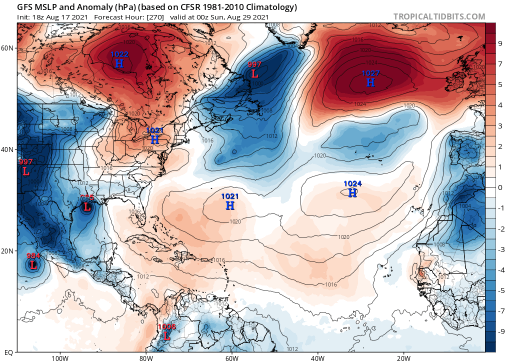
AlphaToOmega wrote:The long-range GFS shows a Central American Gyre storm 270 hours out.


AlphaToOmega wrote:The long-range GFS shows a Central American Gyre storm 270 hours out.

MetroMike wrote:I am interested in anything that forms in the Caribbean that usually heads North and peaks the interest of Floridians.
We'll have to see if this is a trend or a one and done from the GFS.
From a climatological stand point that is more of an October type track, but it is still certainly possible as we have seen storm like Charley do that in August.MetroMike wrote:I am interested in anything that forms in the Caribbean that usually heads North and peaks the interest of Floridians.
We'll have to see if this is a trend or a one and done from the GFS.
Cat5James wrote:MetroMike wrote:I am interested in anything that forms in the Caribbean that usually heads North and peaks the interest of Floridians.
We'll have to see if this is a trend or a one and done from the GFS.
That signal has been there for at least 3 or 4 cycles.. but still far out in fantasyland… seems like more of an October style track as opposed to early September


gatorcane wrote:Something in the BoC/WCAR/Yucatan models are showing looks possible but doubtful it would head towards Florida since that would not be a climo-favored track not to mention the strong ridging we have seen lately.
Users browsing this forum: No registered users and 179 guests


