

We are much higher than the ACE climatological mean at the moment (24.9 ACE vs an average of 16.3). Peak season literally just started.Shell Mound wrote:Teban54 wrote:Shell Mound wrote:Most hyperactive seasons either had more activity earlier in August or featured a cluster of storms developing within a few days of 20 August (or both). The former:
.........Year............# TS 1–19 AugustThe latter:
- 1969............3
- 1886............2
- 1932............1
- 2003............1
- 2020............2
- 1887............2
- 1950............2
- 2017............3
- 2004............4
- 1995............2
- 1896............4
- 2005............2
- 1933............2
...
- 1906: 22 August
- 2010: 21 August
- 1996: 19 August
- 1964: 20 August
- 1999: 18 August
- 1878: 19 August
- 1998: 19 August
- 1926: 20 August
Only Grace has met or exceeded expectations to date. The other systems have mostly underperformed, including Henri. Lots of modelled Category-2+ hurricanes failed to verify in these and other cases. The basin remains too hostile for Category-2+ systems, especially in the deep tropics. So far there is no clear indication that the MDR will become sufficiently favourable to allow for a system to form and attain major-hurricane status between the islands and West Africa, much less become a long-tracking, high-ACE producer. I don’t really care about total NS, given that those numbers tend to be artificially inflated—many “questionable” systems being classified nowadays—and do not really reflect the “intensity” of a season as well as ACE does.
2021 Indicators: SST's / SAL / MSLP / Shear / Steering / Instability / Sat Images
Moderator: S2k Moderators
Forum rules

The posts in this forum are NOT official forecasts and should not be used as such. They are just the opinion of the poster and may or may not be backed by sound meteorological data. They are NOT endorsed by any professional institution or STORM2K. For official information, please refer to products from the National Hurricane Center and National Weather Service.
Re: 2021 Indicators: SST's / SAL / MSLP / Shear / Steering / Instability / Sat Images
10 likes
-
ElectricStorm

- Category 5

- Posts: 5147
- Age: 25
- Joined: Tue Aug 13, 2019 11:23 pm
- Location: Norman, OK
Re: 2021 Indicators: SST's / SAL / MSLP / Shear / Steering / Instability / Sat Images
Shell Mound wrote:Teban54 wrote:Shell Mound wrote:Most hyperactive seasons either had more activity earlier in August or featured a cluster of storms developing within a few days of 20 August (or both). The former:
.........Year............# TS 1–19 AugustThe latter:
- 1969............3
- 1886............2
- 1932............1
- 2003............1
- 2020............2
- 1887............2
- 1950............2
- 2017............3
- 2004............4
- 1995............2
- 1896............4
- 2005............2
- 1933............2
...
- 1906: 22 August
- 2010: 21 August
- 1996: 19 August
- 1964: 20 August
- 1999: 18 August
- 1878: 19 August
- 1998: 19 August
- 1926: 20 August
Only Grace has met or exceeded expectations to date. The other systems have mostly underperformed, including Henri. Lots of modelled Category-2+ hurricanes failed to verify in these and other cases. The basin remains too hostile for Category-2+ systems, especially in the deep tropics. So far there is no clear indication that the MDR will become sufficiently favourable to allow for a system to form and attain major-hurricane status between the islands and West Africa, much less become a long-tracking, high-ACE producer. I don’t really care about total NS, given that those numbers tend to be artificially inflated—many “questionable” systems being classified nowadays—and do not really reflect the “intensity” of a season as well as ACE does.
Grace might make a run at a major, Henri will be a hurricane, Fred nearly became a hurricane despite travelling right over Hispaniola and Cuba, and less than ideal conditions in the Gulf. Elsa was one of the earliest MDR hurricanes on record. Henri is the 4th earliest eighth named storm on record. ACE is above normal. I would argue that none of the storms have underperformed yet this year. Not to mention there hasn't been a major before 8/20 since 2009. It seems like your mindset is that as soon as 8/1 hits, it needs to be a cane fest, otherwise the season might be below average and that's just not how it works.
14 likes
B.S Meteorology, University of Oklahoma '25
Please refer to the NHC, NWS, or SPC for official information.
Please refer to the NHC, NWS, or SPC for official information.
-
Iceresistance

- Category 5
- Posts: 9592
- Age: 22
- Joined: Sat Oct 10, 2020 9:45 am
- Location: Tecumseh, OK/Norman, OK
Re: 2021 Indicators: SST's / SAL / MSLP / Shear / Steering / Instability / Sat Images
Don't assume that no Major Hurricanes before September does mean the season is less active! 2012 is a good example!

6 likes
Bill 2015 & Beta 2020
Winter 2020-2021
All observations are in Tecumseh, OK unless otherwise noted.
Winter posts are focused mainly for Oklahoma & Texas.
Take any of my forecasts with a grain of salt, refer to the NWS, SPC, and NHC for official information
Never say Never with weather! Because ANYTHING is possible!
Winter 2020-2021
All observations are in Tecumseh, OK unless otherwise noted.
Winter posts are focused mainly for Oklahoma & Texas.
Take any of my forecasts with a grain of salt, refer to the NWS, SPC, and NHC for official information
Never say Never with weather! Because ANYTHING is possible!
-
AlphaToOmega
- Category 5
- Posts: 1448
- Joined: Sat Jun 26, 2021 10:51 am
- Location: Somewhere in Massachusetts
Re: 2021 Indicators: SST's / SAL / MSLP / Shear / Steering / Instability / Sat Images
I just love it when people ignore climatology. It makes for some absolutely funny comedy.
I also love it when people talk about a -AMO signal even though the AMO was always positive throughout 2021. It is funny seeing people deny reality.
I also love it when people talk about a -AMO signal even though the AMO was always positive throughout 2021. It is funny seeing people deny reality.
7 likes
-
AlphaToOmega
- Category 5
- Posts: 1448
- Joined: Sat Jun 26, 2021 10:51 am
- Location: Somewhere in Massachusetts
Re: 2021 Indicators: SST's / SAL / MSLP / Shear / Steering / Instability / Sat Images
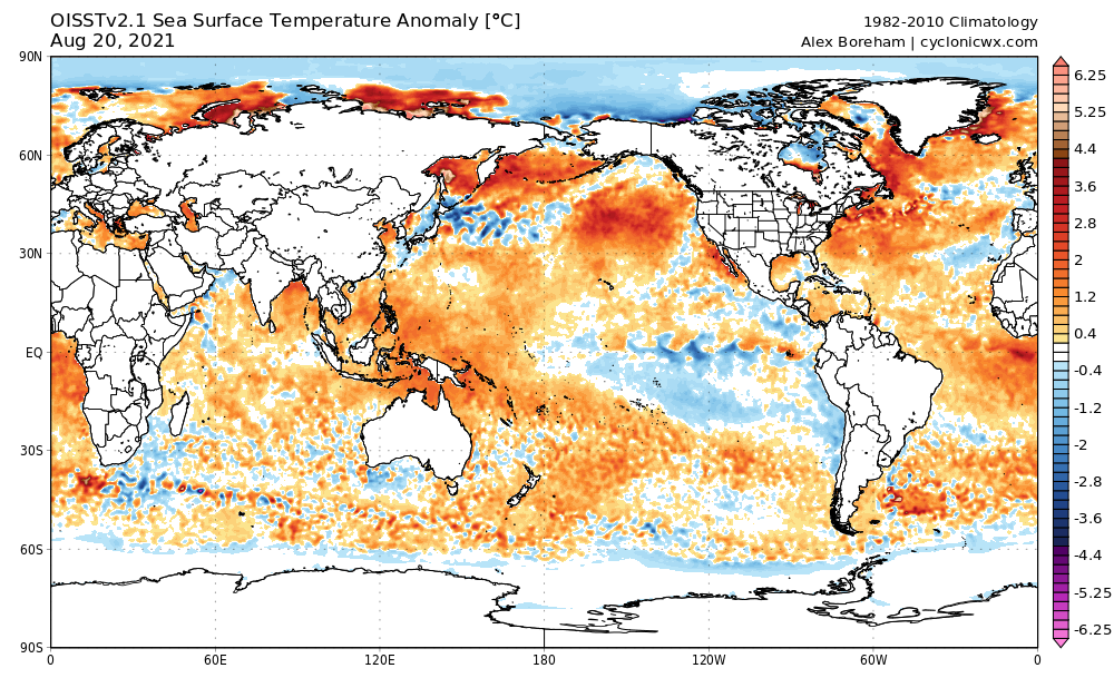
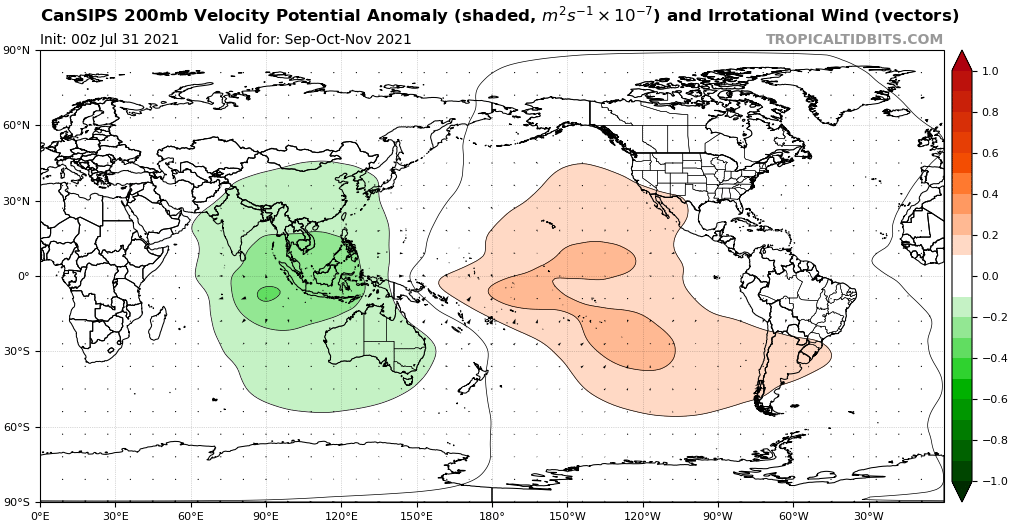
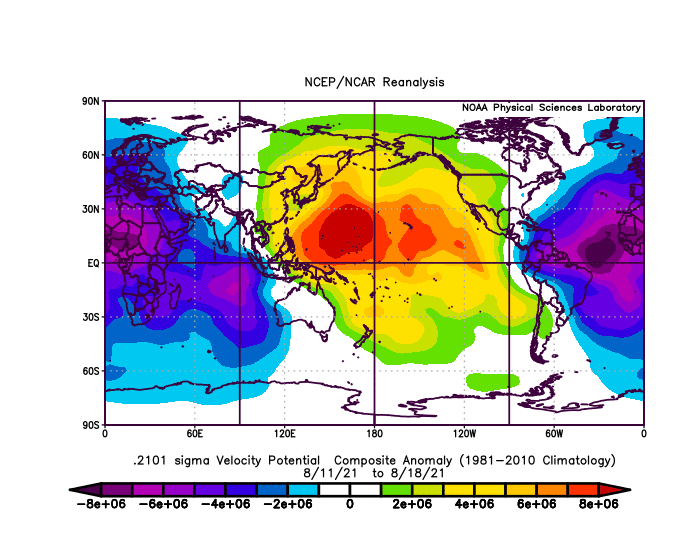
Look at that below-average MDR and sinking air over Africa and the Indian Ocean
Obviously a 1983 repeat
Obviously a 1983 repeat
5 likes
-
Yellow Evan

- Professional-Met

- Posts: 16240
- Age: 27
- Joined: Fri Jul 15, 2011 12:48 pm
- Location: Henderson, Nevada/Honolulu, HI
- Contact:
Re: 2021 Indicators: SST's / SAL / MSLP / Shear / Steering / Instability / Sat Images
Shell Mound wrote:Teban54 wrote:Shell Mound wrote:Most hyperactive seasons either had more activity earlier in August or featured a cluster of storms developing within a few days of 20 August (or both). The former:
.........Year............# TS 1–19 AugustThe latter:
- 1969............3
- 1886............2
- 1932............1
- 2003............1
- 2020............2
- 1887............2
- 1950............2
- 2017............3
- 2004............4
- 1995............2
- 1896............4
- 2005............2
- 1933............2
...
- 1906: 22 August
- 2010: 21 August
- 1996: 19 August
- 1964: 20 August
- 1999: 18 August
- 1878: 19 August
- 1998: 19 August
- 1926: 20 August
Only Grace has met or exceeded expectations to date. The other systems have mostly underperformed, including Henri. Lots of modelled Category-2+ hurricanes failed to verify in these and other cases. The basin remains too hostile for Category-2+ systems, especially in the deep tropics. So far there is no clear indication that the MDR will become sufficiently favourable to allow for a system to form and attain major-hurricane status between the islands and West Africa, much less become a long-tracking, high-ACE producer. I don’t really care about total NS, given that those numbers tend to be artificially inflated—many “questionable” systems being classified nowadays—and do not really reflect the “intensity” of a season as well as ACE does.
Which strong storms have failed to verify? Grace still has a shot at a major before landfall, and Herni once it encounters the right entrance region of a jet streak. And it's only August 20, a date right before activity really begin to ramp up. It's also very funny how you try to use named storms in August to suit your inactivty claim then later on pivot to saying it's not a useful metric by accusing the NHC of inflating named storm count.
13 likes
Re: 2021 Indicators: SST's / SAL / MSLP / Shear / Steering / Instability / Sat Images
Shell Mound wrote:Teban54 wrote:Shell Mound wrote:Most hyperactive seasons either had more activity earlier in August or featured a cluster of storms developing within a few days of 20 August (or both). The former:
.........Year............# TS 1–19 AugustThe latter:
- 1969............3
- 1886............2
- 1932............1
- 2003............1
- 2020............2
- 1887............2
- 1950............2
- 2017............3
- 2004............4
- 1995............2
- 1896............4
- 2005............2
- 1933............2
...
- 1906: 22 August
- 2010: 21 August
- 1996: 19 August
- 1964: 20 August
- 1999: 18 August
- 1878: 19 August
- 1998: 19 August
- 1926: 20 August
Only Grace has met or exceeded expectations to date. The other systems have mostly underperformed, including Henri. Lots of modelled Category-2+ hurricanes failed to verify in these and other cases. The basin remains too hostile for Category-2+ systems, especially in the deep tropics. So far there is no clear indication that the MDR will become sufficiently favourable to allow for a system to form and attain major-hurricane status between the islands and West Africa, much less become a long-tracking, high-ACE producer. I don’t really care about total NS, given that those numbers tend to be artificially inflated—many “questionable” systems being classified nowadays—and do not really reflect the “intensity” of a season as well as ACE does.
We don't need to have long tracking systems that form in the MDR to have major impacts. For example here is are some storms that didn't get their act together until they were close to landmasses Laura 2020, Sally 2020, Delta 2020, Zeta 2020, Harvey 2017, Rita 2005, and Katrina 2005. ACE is a good metric overall to gauge a season but not every storm has to be a massive ACE producer like Ivan or Irma to have just as bad impacts or worse.
5 likes

Re: 2021 Indicators: SST's / SAL / MSLP / Shear / Steering / Instability / Sat Images
Look at all of that OHC in the rest of the Gulf. If anything gets over the Loop Current, we’re in trouble. The possible CAG/Gulf system will need to be monitored closely.

5 likes
Irene '11 Sandy '12 Hermine '16 5/15/2018 Derecho Fay '20 Isaias '20 Elsa '21 Henri '21 Ida '21
I am only a meteorology enthusiast who knows a decent amount about tropical cyclones. Look to the professional mets, the NHC, or your local weather office for the best information.
I am only a meteorology enthusiast who knows a decent amount about tropical cyclones. Look to the professional mets, the NHC, or your local weather office for the best information.

Re: 2021 Indicators: SST's / SAL / MSLP / Shear / Steering / Instability / Sat Images
Shell Mound wrote:Teban54 wrote:Shell Mound wrote:Most hyperactive seasons either had more activity earlier in August or featured a cluster of storms developing within a few days of 20 August (or both). The former:
.........Year............# TS 1–19 AugustThe latter:
- 1969............3
- 1886............2
- 1932............1
- 2003............1
- 2020............2
- 1887............2
- 1950............2
- 2017............3
- 2004............4
- 1995............2
- 1896............4
- 2005............2
- 1933............2
...
- 1906: 22 August
- 2010: 21 August
- 1996: 19 August
- 1964: 20 August
- 1999: 18 August
- 1878: 19 August
- 1998: 19 August
- 1926: 20 August
Only Grace has met or exceeded expectations to date. The other systems have mostly underperformed, including Henri. Lots of modelled Category-2+ hurricanes failed to verify in these and other cases. The basin remains too hostile for Category-2+ systems, especially in the deep tropics. So far there is no clear indication that the MDR will become sufficiently favourable to allow for a system to form and attain major-hurricane status between the islands and West Africa, much less become a long-tracking, high-ACE producer. I don’t really care about total NS, given that those numbers tend to be artificially inflated—many “questionable” systems being classified nowadays—and do not really reflect the “intensity” of a season as well as ACE does.
What "expectations" are you talking about? Models? Forecasts? GFS overinflates every storm north of 30 so by your reasoning every hurricane will underperform. Henri has been even with, and if anything, ahead of NHC forecasts--it was originally forecast at 65mph through 120h. Fred exceeded most model output, which had increasingly had nothing but a wave or depression in the Gulf. Bill and Danny formed when they really weren't supposed to have in the first place. Elsa was continuously forecast to dissipate as well if I remember correctly.
And how favorable the MDR is is meaningless--just look at 2005 and 2020 for example. Or even years like 1985 where only a moderate intensity tropical storm occurred there in late September--which became Gloria once it entered the western basin.
3 likes
The above post is not official and should not be used as such. It is the opinion of the poster and may or may not be backed by sound meteorological data. It is not endorsed by any professional institution or storm2k.org. For official information, please refer to the NHC and NWS products.

Re: 2021 Indicators: SST's / SAL / MSLP / Shear / Steering / Instability / Sat Images
Shell Mound wrote:Only Grace has met or exceeded expectations to date. The other systems have mostly underperformed, including Henri. Lots of modelled Category-2+ hurricanes failed to verify in these and other cases. The basin remains too hostile for Category-2+ systems, especially in the deep tropics. So far there is no clear indication that the MDR will become sufficiently favourable to allow for a system to form and attain major-hurricane status between the islands and West Africa, much less become a long-tracking, high-ACE producer. I don’t really care about total NS, given that those numbers tend to be artificially inflated—many “questionable” systems being classified nowadays—and do not really reflect the “intensity” of a season as well as ACE does.
The notion that Henri has 'underperformed' is confusing. It was entirely missed by model guidance until well after undergoing TCG. The NHC has been very persistent in forecasting a leveling-off (~50-60kt) through the end of the week, which is exactly what has occurred. Henri has only been underperforming relative to hurricane models, which were extreme outliers to begin with. Eventually (likely in September) we will get a wave in the wrong place and wrong time.
If you only care about ACE, the Atlantic is currently over 150% of the climo normal thru today and slightly above 2020 at the same time.
11 likes
Kendall -> SLO -> PBC
Memorable Storms: Katrina (for its Florida landfall...) Wilma Matthew Irma
Memorable Storms: Katrina (for its Florida landfall...) Wilma Matthew Irma
-
cycloneye

- Admin

- Posts: 149508
- Age: 69
- Joined: Thu Oct 10, 2002 10:54 am
- Location: San Juan, Puerto Rico
Re: 2021 Indicators: SST's / SAL / MSLP / Shear / Steering / Instability / Sat Images
The average ACE for August 20 is 16.3 and 2021 as of 5 PM EDT has 25.9 ACE units.
4 likes
Visit the Caribbean-Central America Weather Thread where you can find at first post web cams,radars
and observations from Caribbean basin members Click Here
and observations from Caribbean basin members Click Here
-
AxaltaRacing24
- Category 5
- Posts: 1774
- Age: 25
- Joined: Wed Jul 27, 2016 11:14 am
- Location: Jupiter, FL
Re: 2021 Indicators: SST's / SAL / MSLP / Shear / Steering / Instability / Sat Images
Hammy wrote:Shell Mound wrote:Teban54 wrote:
Only Grace has met or exceeded expectations to date. The other systems have mostly underperformed, including Henri. Lots of modelled Category-2+ hurricanes failed to verify in these and other cases. The basin remains too hostile for Category-2+ systems, especially in the deep tropics. So far there is no clear indication that the MDR will become sufficiently favourable to allow for a system to form and attain major-hurricane status between the islands and West Africa, much less become a long-tracking, high-ACE producer. I don’t really care about total NS, given that those numbers tend to be artificially inflated—many “questionable” systems being classified nowadays—and do not really reflect the “intensity” of a season as well as ACE does.
What "expectations" are you talking about? Models? Forecasts? GFS overinflates every storm north of 30 so by your reasoning every hurricane will underperform. Henri has been even with, and if anything, ahead of NHC forecasts--it was originally forecast at 65mph through 120h. Fred exceeded most model output, which had increasingly had nothing but a wave or depression in the Gulf. Bill and Danny formed when they really weren't supposed to have in the first place. Elsa was continuously forecast to dissipate as well if I remember correctly.
And how favorable the MDR is is meaningless--just look at 2005 and 2020 for example. Or even years like 1985 where only a moderate intensity tropical storm occurred there in late September--which became Gloria once it entered the western basin.
The MDR is overrated IMO in terms of how crucial it is for an active season. Notice how the two most active seasons on record (2005 and 2020), did not produce many MDR "long-trackers".
4 likes
-
toad strangler

- S2K Supporter

- Posts: 4546
- Joined: Sun Jul 28, 2013 3:09 pm
- Location: Earth
- Contact:
Re: 2021 Indicators: SST's / SAL / MSLP / Shear / Steering / Instability / Sat Images
AxaltaRacing24 wrote:Hammy wrote:Shell Mound wrote:Only Grace has met or exceeded expectations to date. The other systems have mostly underperformed, including Henri. Lots of modelled Category-2+ hurricanes failed to verify in these and other cases. The basin remains too hostile for Category-2+ systems, especially in the deep tropics. So far there is no clear indication that the MDR will become sufficiently favourable to allow for a system to form and attain major-hurricane status between the islands and West Africa, much less become a long-tracking, high-ACE producer. I don’t really care about total NS, given that those numbers tend to be artificially inflated—many “questionable” systems being classified nowadays—and do not really reflect the “intensity” of a season as well as ACE does.
What "expectations" are you talking about? Models? Forecasts? GFS overinflates every storm north of 30 so by your reasoning every hurricane will underperform. Henri has been even with, and if anything, ahead of NHC forecasts--it was originally forecast at 65mph through 120h. Fred exceeded most model output, which had increasingly had nothing but a wave or depression in the Gulf. Bill and Danny formed when they really weren't supposed to have in the first place. Elsa was continuously forecast to dissipate as well if I remember correctly.
And how favorable the MDR is is meaningless--just look at 2005 and 2020 for example. Or even years like 1985 where only a moderate intensity tropical storm occurred there in late September--which became Gloria once it entered the western basin.
The MDR is overrated IMO in terms of how crucial it is for an active season. Notice how the two most active seasons on record (2005 and 2020), did not produce many MDR "long-trackers".
Shell Mound puts entirely too much emphasis on the MDR when talking about actual hurricanes. Yes, the MDR is THE breeding ground of Atlantic Basin cyclones but that doesn't mean that systems need to be hurricanes when inside the MDR. It's the average AEW or other entity that juices up a bit in this region that really matters. These "embryos" many times go on to blossom well outside the published borders of MDR. Whether this is the sub tropics or points much further west such as the GOM, Bahama region, etc.
12 likes
My Weather Station
https://www.wunderground.com/dashboard/pws/KFLPORTS603
https://www.wunderground.com/dashboard/pws/KFLPORTS603
-
CyclonicFury

- Category 5
- Posts: 2035
- Age: 27
- Joined: Sun Jul 02, 2017 12:32 pm
- Location: NC
- Contact:
Re: 2021 Indicators: SST's / SAL / MSLP / Shear / Steering / Instability / Sat Images
Shell Mound wrote:Teban54 wrote:Shell Mound wrote:Most hyperactive seasons either had more activity earlier in August or featured a cluster of storms developing within a few days of 20 August (or both). The former:
.........Year............# TS 1–19 AugustThe latter:
- 1969............3
- 1886............2
- 1932............1
- 2003............1
- 2020............2
- 1887............2
- 1950............2
- 2017............3
- 2004............4
- 1995............2
- 1896............4
- 2005............2
- 1933............2
...
- 1906: 22 August
- 2010: 21 August
- 1996: 19 August
- 1964: 20 August
- 1999: 18 August
- 1878: 19 August
- 1998: 19 August
- 1926: 20 August
Only Grace has met or exceeded expectations to date. The other systems have mostly underperformed, including Henri. Lots of modelled Category-2+ hurricanes failed to verify in these and other cases. The basin remains too hostile for Category-2+ systems, especially in the deep tropics. So far there is no clear indication that the MDR will become sufficiently favourable to allow for a system to form and attain major-hurricane status between the islands and West Africa, much less become a long-tracking, high-ACE producer. I don’t really care about total NS, given that those numbers tend to be artificially inflated—many “questionable” systems being classified nowadays—and do not really reflect the “intensity” of a season as well as ACE does.
BUMP
13 likes
NCSU B.S. in Meteorology Class of 2021. Tropical weather blogger at http://www.cyclonicfury.com. My forecasts and thoughts are NOT official, for official forecasts please consult the National Hurricane Center.
-
AlphaToOmega
- Category 5
- Posts: 1448
- Joined: Sat Jun 26, 2021 10:51 am
- Location: Somewhere in Massachusetts
Re: 2021 Indicators: SST's / SAL / MSLP / Shear / Steering / Instability / Sat Images
Here is some climatology from the NHC's website. I cannot emphasize enough that the early season is a terrible bellwether period, but we are way ahead of schedule. The first hurricane does not typically form until mid-August, and the first major hurricane does not typically form until early September.
Table 1. Progress of the average Atlantic season (1966-2009). Date upon which the following number of events would normally have occurred.
Number Named systems Hurricanes Category 3 or greater
1 July 9 Aug 10 Sep 4
2 Aug 1 Aug 28 Oct 3
3 Aug 13 Sep 9 -
4 Aug 23 Sep 21 -
5 Aug 31 Oct 7 -
6 Sep 8 Nov 23 -
7 Sep 16 - -
8 Sep 24 - -
9 Oct 4 - -
10 Oct 19 - -
11 Nov 23 - -
Number Named systems Hurricanes Category 3 or greater
1 July 9 Aug 10 Sep 4
2 Aug 1 Aug 28 Oct 3
3 Aug 13 Sep 9 -
4 Aug 23 Sep 21 -
5 Aug 31 Oct 7 -
6 Sep 8 Nov 23 -
7 Sep 16 - -
8 Sep 24 - -
9 Oct 4 - -
10 Oct 19 - -
11 Nov 23 - -
6 likes
-
MarioProtVI
- Category 5
- Posts: 1034
- Age: 24
- Joined: Sun Sep 29, 2019 7:33 pm
- Location: New Jersey
Re: 2021 Indicators: SST's / SAL / MSLP / Shear / Steering / Instability / Sat Images
And just like that we (most likely) have our first major with Grace. THE SWITCH HAS FLIPPED
8 likes
-
Stormybajan

- Category 1

- Posts: 453
- Joined: Thu May 20, 2021 3:21 pm
- Location: Windward Islands
Re: 2021 Indicators: SST's / SAL / MSLP / Shear / Steering / Instability / Sat Images
The August 20th switch has been flipped!!  Grace might be our first major hurricane of the season at 11!
Grace might be our first major hurricane of the season at 11!
9 likes
Sad West Indies and Manchester United fan ⚽️
Re: 2021 Indicators: SST's / SAL / MSLP / Shear / Steering / Instability / Sat Images
Right on cue 1st major of the season on August 20th and also this is a perfect example that a storm doesn't need to get its act together in the MDR to still be a deadly hurricane.
6 likes
-
hurricanes1234
- Category 5
- Posts: 2908
- Joined: Sat Jul 28, 2012 6:19 pm
- Location: Trinidad and Tobago
Re: 2021 Indicators: SST's / SAL / MSLP / Shear / Steering / Instability / Sat Images
Shell Mound wrote:Teban54 wrote:Shell Mound wrote:Most hyperactive seasons either had more activity earlier in August or featured a cluster of storms developing within a few days of 20 August (or both). The former:
.........Year............# TS 1–19 AugustThe latter:
- 1969............3
- 1886............2
- 1932............1
- 2003............1
- 2020............2
- 1887............2
- 1950............2
- 2017............3
- 2004............4
- 1995............2
- 1896............4
- 2005............2
- 1933............2
...
- 1906: 22 August
- 2010: 21 August
- 1996: 19 August
- 1964: 20 August
- 1999: 18 August
- 1878: 19 August
- 1998: 19 August
- 1926: 20 August
Only Grace has met or exceeded expectations to date. The other systems have mostly underperformed, including Henri. Lots of modelled Category-2+ hurricanes failed to verify in these and other cases. The basin remains too hostile for Category-2+ systems, especially in the deep tropics. So far there is no clear indication that the MDR will become sufficiently favourable to allow for a system to form and attain major-hurricane status between the islands and West Africa, much less become a long-tracking, high-ACE producer. I don’t really care about total NS, given that those numbers tend to be artificially inflated—many “questionable” systems being classified nowadays—and do not really reflect the “intensity” of a season as well as ACE does.
The Atlantic right now be like "hold my beer".
7 likes
PLEASE NOTE: With the exception of information from weather agencies that I may copy and paste here, my posts will NEVER be official, since I am NOT a meteorologist. They are solely my amateur opinion, and may or may not be accurate. Therefore, please DO NOT use them as official details, particularly when making important decisions. Thank you.
Who is online
Users browsing this forum: No registered users and 431 guests