
ATL: GRACE - Remnants - Discussion
Moderator: S2k Moderators
-
ElectricStorm

- Category 5

- Posts: 5147
- Age: 25
- Joined: Tue Aug 13, 2019 11:23 pm
- Location: Norman, OK
Re: ATL: GRACE - Hurricane - Discussion
Night vis
9 likes
B.S Meteorology, University of Oklahoma '25
Please refer to the NHC, NWS, or SPC for official information.
Please refer to the NHC, NWS, or SPC for official information.

Re: ATL: GRACE - Hurricane - Discussion
Now that we've bagged a major in August, getting 1 or 2 more in sept and 1 or 2 more in october makes that 3-5 total pretty manageable.
1 likes
-
supercane4867
- Category 5
- Posts: 4966
- Joined: Wed Nov 14, 2012 10:43 am
Re: ATL: GRACE - Hurricane - Discussion
Running out of time for the eye to fully clear, but won't make much difference in terms of strength at this point

1 likes
-
EquusStorm
- Category 5
- Posts: 1649
- Age: 35
- Joined: Thu Nov 07, 2013 1:04 pm
- Location: Jasper, AL
- Contact:
Re: ATL: GRACE - Hurricane - Discussion
Eye seems a bit more defined and overall more symmetrical, might pull off just a little more intensification before coming ashore.
0 likes
Colors of lost purpose on the canvas of irrelevance
Not a meteorologist, in fact more of an idiot than anything. You should probably check with the NHC or a local NWS office for official information.
Not a meteorologist, in fact more of an idiot than anything. You should probably check with the NHC or a local NWS office for official information.
-
skyline385

- Category 5
- Posts: 2728
- Age: 35
- Joined: Wed Aug 26, 2020 11:15 pm
- Location: Houston TX
Re: ATL: GRACE - Hurricane - Discussion
psyclone wrote:Now that we've bagged a major in August, getting 1 or 2 more in sept and 1 or 2 more in october makes that 3-5 total pretty manageable.
We will most likely see some by August as the Gulf is literally boiling along with the SW Caribbean as well. With the MJO moving over the Caribbean, the GFS has been hinting at a CAG for a while now.
Last edited by skyline385 on Fri Aug 20, 2021 11:46 pm, edited 2 times in total.
0 likes
Re: ATL: GRACE - Hurricane - Discussion
skyline385 wrote:psyclone wrote:Now that we've bagged a major in August, getting 1 or 2 more in sept and 1 or 2 more in october makes that 3-5 total pretty manageable.
We will most likely see some by August as the Gulf is literally boiling along with the SW Caribbean as well. With the MJO moving over the Caribbean, the GFS has been hinting at a CAG for a while now.
It's possible we get another major in August. As Grace has just demonstrated...things can escalate quickly
1 likes
-
skyline385
- Category 5
- Posts: 2728
- Age: 35
- Joined: Wed Aug 26, 2020 11:15 pm
- Location: Houston TX
Re: ATL: GRACE - Hurricane - Discussion
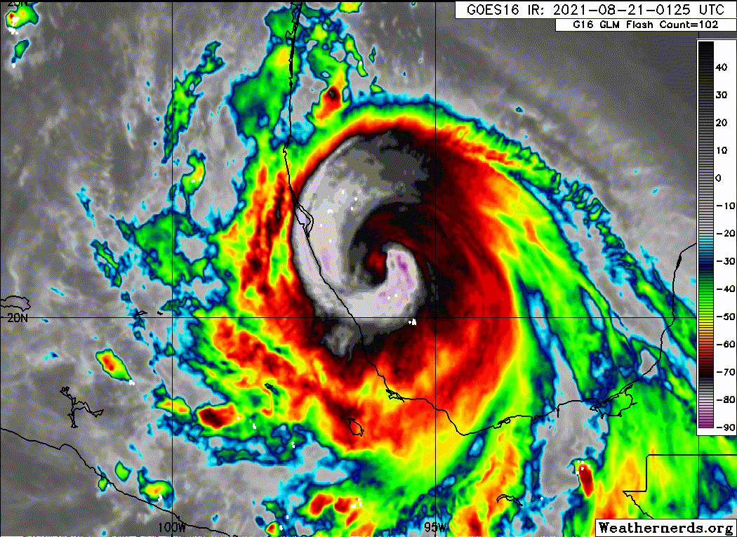
And there's the eye..

Last edited by skyline385 on Fri Aug 20, 2021 11:48 pm, edited 1 time in total.
2 likes
-
Sciencerocks
- Category 5
- Posts: 10186
- Age: 40
- Joined: Thu Jul 06, 2017 1:51 am

Re: ATL: GRACE - Hurricane - Discussion
skyline385 wrote:AxaltaRacing24 wrote:AtlanticWind wrote:We are about to have 3 hurricanes and 1 major by August 21st.
I dont think we will be hearing on a lot of season cancel posts
But I could be wrong
There is literally nothing to cancel anymore. This is quite the season so far.
People seem to be freaking out just because we had a Cat 3 in the BoC of all places in August but are forgetting that a hyperactive season like 2005 had a Cat 4 and Cat 5 in July. Even if we ignore 2005, there have been decent no. of Cat 3 and above hurricanes before August 20.
This season can get bad because of the SST in the Gulf but Grace is not an example of it. Fred had literally free time in the Gulf as well across 30-31C, and it barely managed Cat 1. Most storms this season so far have been tame compared to an actual hyperactive season. So let's just relax and be prepared, and let's not freak out because of a Cat 3 in the most favourable spots in the Gulf.
2005 was an anomaly as July was by and far the most intense on record. Since 1980 (40 years prior to this year) having a major hurricane on or prior to August 20 has only happened 10 times: 1980, 83, 91, 95, 96, 2000, 04, 05, 08, and 09. The last time was 12 years ago. Half of those were hyperactive (all ending August with at least 7 storms and three hurricanes)--none of the non-hyper years had more than four storms total by late August, and only one of them (1980, which was close to hyperactive) had more than two hurricanes by then.
Statistically, that this happened is in fact an indicator of a hyperactive or near-hyperactive season--especially given how increasingly late it's gotten to have a first major.
10 likes
The above post is not official and should not be used as such. It is the opinion of the poster and may or may not be backed by sound meteorological data. It is not endorsed by any professional institution or storm2k.org. For official information, please refer to the NHC and NWS products.
-
Hypercane_Kyle

- Category 5
- Posts: 3465
- Joined: Sat Mar 07, 2015 7:58 pm
- Location: Cape Canaveral, FL
Re: ATL: GRACE - Hurricane - Discussion
Recon finished right as Grace's IR presentation is looking its best. I think it's probably close to 115 knots right now considering the intense rate of intensification, but the NHC will probably maintain 105 knots.
0 likes
My posts are my own personal opinion, defer to the National Hurricane Center (NHC) and other NOAA products for decision making during hurricane season.
-
ElectricStorm
- Category 5
- Posts: 5147
- Age: 25
- Joined: Tue Aug 13, 2019 11:23 pm
- Location: Norman, OK
Re: ATL: GRACE - Hurricane - Discussion
Looks like landfall should be within the next hour, maybe even 30 minutes or so.
0 likes
B.S Meteorology, University of Oklahoma '25
Please refer to the NHC, NWS, or SPC for official information.
Please refer to the NHC, NWS, or SPC for official information.
-
CrazyC83
- Professional-Met

- Posts: 34315
- Joined: Tue Mar 07, 2006 11:57 pm
- Location: Deep South, for the first time!
Re: ATL: GRACE - Hurricane - Discussion
If things stay as is, I'd go with 110 kt for the landfall intensity, with a pressure of 962 mb.
0 likes
-
galaxy401

- Category 5
- Posts: 2446
- Age: 30
- Joined: Sat Aug 25, 2012 9:04 pm
- Location: Casa Grande, Arizona
Re: ATL: GRACE - Hurricane - Discussion
Considering the Pressure drop on that last pass and the still improving appearance, I would go with 125 mph for landfall. I won't rule out that it could be trying to reach for Cat 4 as well.
1 likes
Got my eyes on moving right into Hurricane Alley: Florida.
-
CrazyC83
- Professional-Met
- Posts: 34315
- Joined: Tue Mar 07, 2006 11:57 pm
- Location: Deep South, for the first time!
Re: ATL: GRACE - Hurricane - Discussion
galaxy401 wrote:Considering the Pressure drop on that last pass and the still improving appearance, I would go with 125 mph for landfall. I won't rule out that it could be trying to reach for Cat 4 as well.
Unless Josh captures a pressure in the 950s supporting a steep drop, I think that may be a bridge too far. But 110 kt seems reasonable.
0 likes
-
skyline385
- Category 5
- Posts: 2728
- Age: 35
- Joined: Wed Aug 26, 2020 11:15 pm
- Location: Houston TX
Re: ATL: GRACE - Hurricane - Discussion
Hammy wrote:skyline385 wrote:AxaltaRacing24 wrote:There is literally nothing to cancel anymore. This is quite the season so far.
People seem to be freaking out just because we had a Cat 3 in the BoC of all places in August but are forgetting that a hyperactive season like 2005 had a Cat 4 and Cat 5 in July. Even if we ignore 2005, there have been decent no. of Cat 3 and above hurricanes before August 20.
This season can get bad because of the SST in the Gulf but Grace is not an example of it. Fred had literally free time in the Gulf as well across 30-31C, and it barely managed Cat 1. Most storms this season so far have been tame compared to an actual hyperactive season. So let's just relax and be prepared, and let's not freak out because of a Cat 3 in the most favourable spots in the Gulf.
2005 was an anomaly as July was by and far the most intense on record. Since 1980 (40 years prior to this year) having a major hurricane on or prior to August 20 has only happened 10 times: 1980, 83, 91, 95, 96, 2000, 04, 05, 08, and 09. The last time was 12 years ago. Half of those were hyperactive (all ending August with at least 7 storms and three hurricanes)--none of the non-hyper years had more than four storms total by late August, and only one of them (1980, which was close to hyperactive) had more than two hurricanes by then.
Statistically, that this happened is in fact an indicator of a hyperactive or near-hyperactive season--especially given how increasingly late it's gotten to have a first major.
I mean, whoever read CSU's mid season report would already know that this season is going to be near hyper-active. However some people seemed to be suggesting that a Cat 3 in BoC implies another record breaking season as there were several comparisons to the 2020 season which is what I was referring to when I said to stop freaking out.
Here are the interesting parts from the CSU report which really stuck out to me


2 likes

Re: ATL: GRACE - Hurricane - Discussion
CrazyC83 wrote:galaxy401 wrote:Considering the Pressure drop on that last pass and the still improving appearance, I would go with 125 mph for landfall. I won't rule out that it could be trying to reach for Cat 4 as well.
Unless Josh captures a pressure in the 950s supporting a steep drop, I think that may be a bridge too far. But 110 kt seems reasonable.
Isn't 110kts about 126mph?
0 likes
-
CrazyC83
- Professional-Met
- Posts: 34315
- Joined: Tue Mar 07, 2006 11:57 pm
- Location: Deep South, for the first time!
Re: ATL: GRACE - Hurricane - Discussion
rsbIII wrote:CrazyC83 wrote:galaxy401 wrote:Considering the Pressure drop on that last pass and the still improving appearance, I would go with 125 mph for landfall. I won't rule out that it could be trying to reach for Cat 4 as well.
Unless Josh captures a pressure in the 950s supporting a steep drop, I think that may be a bridge too far. But 110 kt seems reasonable.
Isn't 110kts about 126mph?
That's 125 mph - strong category 3.
0 likes
-
Shell Mound
- Category 5
- Posts: 2432
- Age: 33
- Joined: Thu Sep 07, 2017 3:39 pm
- Location: St. Petersburg, FL → Scandinavia
Re: ATL: GRACE - Hurricane - Discussion
The eye is rapidly clearing out on IR and contracting on radar, so Grace is clearly making every effort to approach Category-4 intensity at landfall.
0 likes
CVW / MiamiensisWx / Shell Mound
The posts in this forum are NOT official forecasts and should not be used as such. They are just the opinion of the poster and may or may not be backed by sound meteorological data. They are NOT endorsed by any professional institution or STORM2K. For official information, please refer to products from the NHC and NWS.

Re: ATL: GRACE - Hurricane - Discussion
Reminds me of Michael, RI'ing till the end. That hot water sure makes miracles.
0 likes
Personal Forecast Disclaimer:
The posts in this forum are NOT official forecast and should not be used as such. They are just the opinion of the poster and may or may not be backed by sound meteorological data. For official information, please refer to the NHC and NWS products.
The posts in this forum are NOT official forecast and should not be used as such. They are just the opinion of the poster and may or may not be backed by sound meteorological data. For official information, please refer to the NHC and NWS products.
-
Shell Mound
- Category 5
- Posts: 2432
- Age: 33
- Joined: Thu Sep 07, 2017 3:39 pm
- Location: St. Petersburg, FL → Scandinavia
Re: ATL: GRACE - Hurricane - Discussion
https://twitter.com/pppapin/status/1428931590542045184
Radar imagery currently suggests that landfall is occurring just north of Gutiérrez Zamora in the Mexican state of Veracruz.
Radar imagery currently suggests that landfall is occurring just north of Gutiérrez Zamora in the Mexican state of Veracruz.
0 likes
CVW / MiamiensisWx / Shell Mound
The posts in this forum are NOT official forecasts and should not be used as such. They are just the opinion of the poster and may or may not be backed by sound meteorological data. They are NOT endorsed by any professional institution or STORM2K. For official information, please refer to products from the NHC and NWS.
Who is online
Users browsing this forum: No registered users and 47 guests