ATL: HENRI - Remnants - Discussion
Moderator: S2k Moderators

Re: ATL: HENRI - Tropical Storm - Discussion
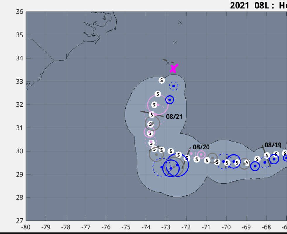
NOAA is out in the storm right now, and AF is headed out there currently as well. So far NOAA has found a lowest pressure of 992.4mb extrapolated. 57kt SFMR so far, although associated flight level winds lower. Rain rate was only 14mm/hr though and Henri was already at that intensity, so it seems valid. We’ll have to see if they find evidence for the hurricane upgrade.
0 likes
Solar Aquarian
Lunar Cancerian
 Sagittarian
Lunar Cancerian


Re: ATL: HENRI - Tropical Storm - Discussion
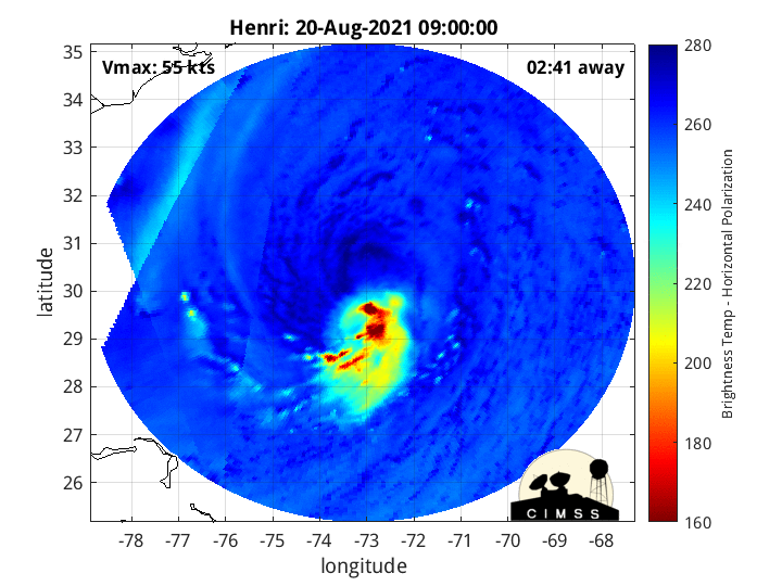
Looks like the warm core took a little beating since I last posted the AMSU thermal analysis.
On the other hand the cold pocket has deepened.
Need some strong convection to heat up the core.

On the other hand the cold pocket has deepened.
Need some strong convection to heat up the core.
0 likes

Re: ATL: HENRI - Tropical Storm - Discussion
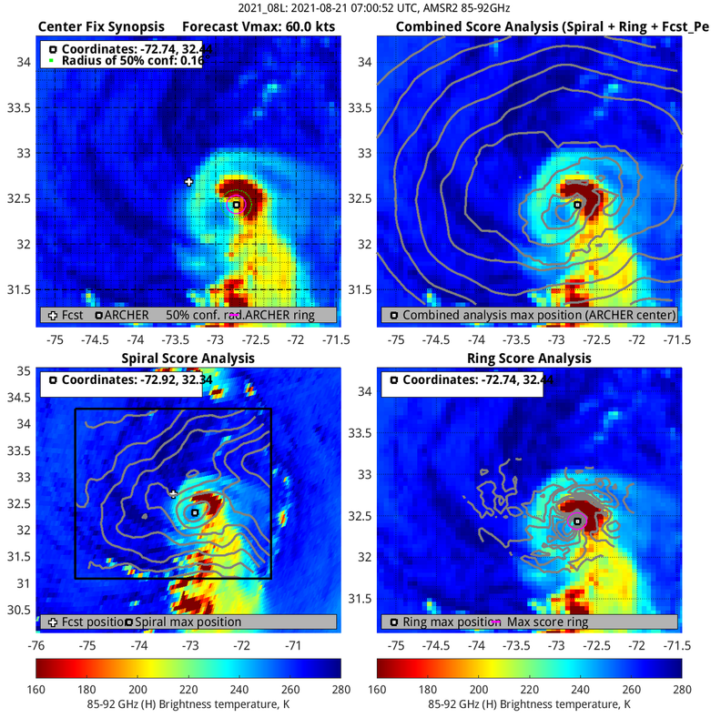
MLC and LLC still look somewhat displaced but not as much as yesterday, at least from 4 hrs ago.

0 likes

Re: ATL: HENRI - Tropical Storm - Discussion
GCANE wrote:[url]https://i.postimg.cc/J0cRNdBj/last24hrs.gif [/url]
Watching that was like sitting at a stop sign waiting to turn into traffic, then saying screw it and flooring it.
1 likes
Once I see the REDS and GREENS Converge on a Base Velocity. ... I'm There!!
This is NOT an Official Forecast....Just my Opinion. For official information, please refer to the NHC and NWS products.
HIGHLIGHTS : '13 El Reno Tornado : 2013 Storm Chaser Tour, Joaquin; SC flood event, Matthew '16, Lowcountry Snow storm Jan '18
This is NOT an Official Forecast....Just my Opinion. For official information, please refer to the NHC and NWS products.
HIGHLIGHTS : '13 El Reno Tornado : 2013 Storm Chaser Tour, Joaquin; SC flood event, Matthew '16, Lowcountry Snow storm Jan '18

Re: ATL: HENRI - Tropical Storm - Discussion
Good timing for Recon to be in there if that Microwave is showing what it is
0 likes
Once I see the REDS and GREENS Converge on a Base Velocity. ... I'm There!!
This is NOT an Official Forecast....Just my Opinion. For official information, please refer to the NHC and NWS products.
HIGHLIGHTS : '13 El Reno Tornado : 2013 Storm Chaser Tour, Joaquin; SC flood event, Matthew '16, Lowcountry Snow storm Jan '18
This is NOT an Official Forecast....Just my Opinion. For official information, please refer to the NHC and NWS products.
HIGHLIGHTS : '13 El Reno Tornado : 2013 Storm Chaser Tour, Joaquin; SC flood event, Matthew '16, Lowcountry Snow storm Jan '18
Re: ATL: HENRI - Tropical Storm - Discussion
The cooling of the core has reduced lapse rate and subsequently rain rate has diminished
 happiness is a journey not a destination poem
happiness is a journey not a destination poem
0 likes
Re: ATL: HENRI - Tropical Storm - Discussion
Feeding off a ridge of 4000 CAPE air coming off the Gulf Stream
0 likes
Re: ATL: HENRI - Tropical Storm - Discussion
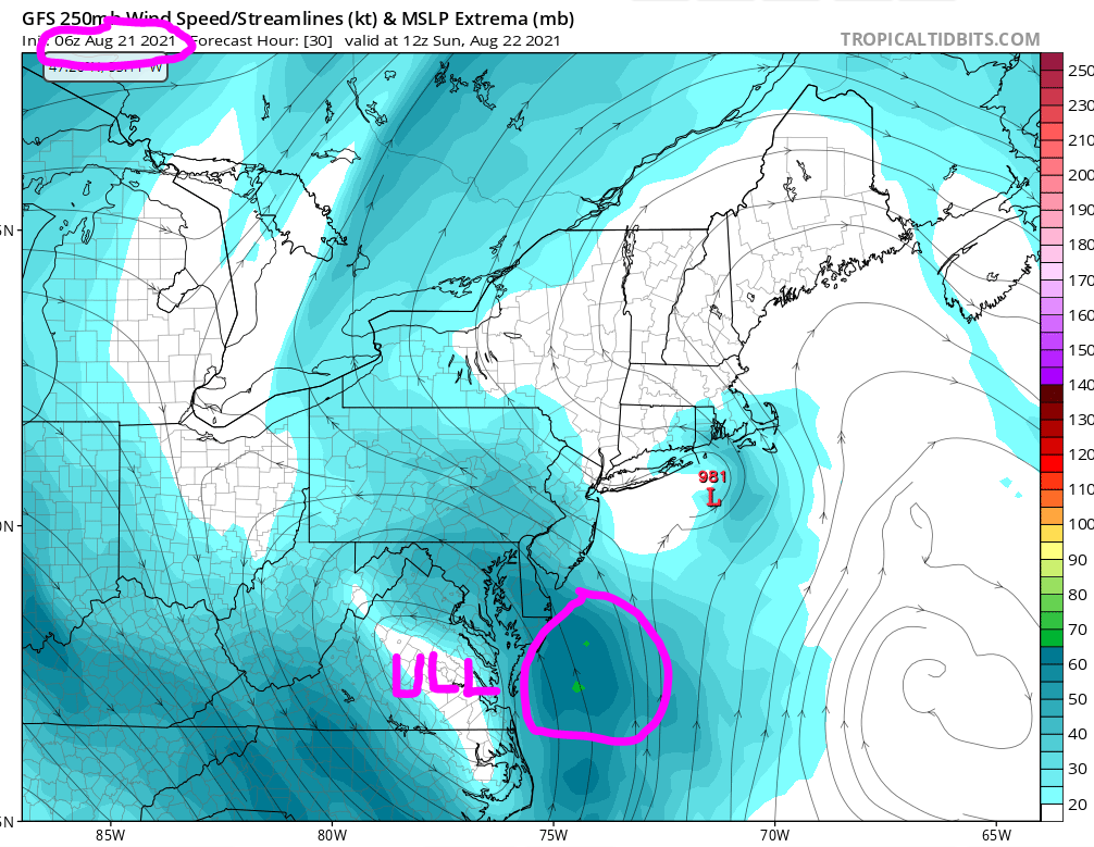
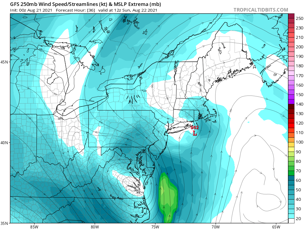
Latest GFS has the ULL weakening somewhat from the previous forecast.
Nudging Henri's forecast track back east a bit.
 how to screenshot on windows
Nudging Henri's forecast track back east a bit.
how to screenshot on windows
0 likes
Re: ATL: HENRI - Tropical Storm - Discussion
GCANE wrote:Latest GFS has the ULL weakening somewhat from the previous forecast.
Nudging Henri's forecast track back east a bit.
[url]https://i.postimg.cc/3x978JVh/G1.png [/url]
[url]https://i.postimg.cc/pLVb6MT6/gfs-uv250-neus-7.png [/url]how to screenshot on windows
Just a heads up, but your posts seem to be attaching extra links to the images you’re posting. A couple of your previous posts this morning had links to poems, and I thought “Hey, I guess he’s sneaking in poems he likes to his posts, that’s cool” but this post has a link to directions on how to screenshot for Windows and that doesn’t seem like you meant to do it.
0 likes
Solar Aquarian
Lunar Cancerian
Sagittarian
Lunar Cancerian

Re: ATL: HENRI - Tropical Storm - Discussion
Looks like the pressure is maybe around 992mb from recon.
0 likes
Personal Forecast Disclaimer:
The posts in this forum are NOT official forecast and should not be used as such. They are just the opinion of the poster and may or may not be backed by sound meteorological data. They are NOT endorsed by any professional institution or storm2k.org. For official information, please refer to the NHC and NWS products.
The posts in this forum are NOT official forecast and should not be used as such. They are just the opinion of the poster and may or may not be backed by sound meteorological data. They are NOT endorsed by any professional institution or storm2k.org. For official information, please refer to the NHC and NWS products.
Re: ATL: HENRI - Tropical Storm - Discussion
Looks like recon will tag it about 992mb, slightly east of forecast track.
Good thing for NYC.
Good thing for NYC.
0 likes
Re: ATL: HENRI - Tropical Storm - Discussion
Chris90 wrote:GCANE wrote:Latest GFS has the ULL weakening somewhat from the previous forecast.
Nudging Henri's forecast track back east a bit.
[url]https://i.postimg.cc/3x978JVh/G1.png [/url]
[url]https://i.postimg.cc/pLVb6MT6/gfs-uv250-neus-7.png [/url]how to screenshot on windows
Just a heads up, but your posts seem to be attaching extra links to the images you’re posting. A couple of your previous posts this morning had links to poems, and I thought “Hey, I guess he’s sneaking in poems he likes to his posts, that’s cool” but this post has a link to directions on how to screenshot for Windows and that doesn’t seem like you meant to do it.
Those links are auto generated from the image-hosting site I am using. It only happens when I link an image's URL directly. Sorry if this may be of offense.
0 likes

Re: ATL: HENRI - Tropical Storm - Discussion
GCANE wrote:Chris90 wrote:GCANE wrote:Latest GFS has the ULL weakening somewhat from the previous forecast.
Nudging Henri's forecast track back east a bit.
[url]https://i.postimg.cc/3x978JVh/G1.png [/url]
[url]https://i.postimg.cc/pLVb6MT6/gfs-uv250-neus-7.png [/url]how to screenshot on windows
Just a heads up, but your posts seem to be attaching extra links to the images you’re posting. A couple of your previous posts this morning had links to poems, and I thought “Hey, I guess he’s sneaking in poems he likes to his posts, that’s cool” but this post has a link to directions on how to screenshot for Windows and that doesn’t seem like you meant to do it.
Those links are auto generated from the image-hosting site I am using. It only happens when I link an image's URL directly. Sorry if this may be of offense.
Oh, no no, I wasn’t offended, I just didn’t know if you were aware your images had tag-a-long links, so I wanted to give you a heads up.
Anyways, back to Henri. Anyone have guesses for peak intensity? I’m thinking 85-90kts.
0 likes
Solar Aquarian
Lunar Cancerian
Sagittarian
Lunar Cancerian


Re: ATL: HENRI - Tropical Storm - Discussion
The center looks a bit more organized this morning than last night. The range of minimum pressures have contracted significantly, suggesting the vortexes are much closer to being stacked. However, the northern side is still lacking in winds and convection. Henri has like 24 hours left over 28-30C waters, so strengthening is likely, but this structure does not favor RI.
1 likes
Irene '11 Sandy '12 Hermine '16 5/15/2018 Derecho Fay '20 Isaias '20 Elsa '21 Henri '21 Ida '21
I am only a meteorology enthusiast who knows a decent amount about tropical cyclones. Look to the professional mets, the NHC, or your local weather office for the best information.
I am only a meteorology enthusiast who knows a decent amount about tropical cyclones. Look to the professional mets, the NHC, or your local weather office for the best information.
Re: ATL: HENRI - Tropical Storm - Discussion
Starting to stack now, next few hours will tell if he can take off.
G. Eye Shape: Elliptical (oval shaped)
G. Orientation of Major Axis in Elliptical Eye: 20° to 200° (NNE to SSW)
G. Length of Major Axis in Elliptical Eye: 20 nautical miles
G. Length of Minor Axis in Elliptical Eye: 10 nautical miles
G. Orientation of Major Axis in Elliptical Eye: 20° to 200° (NNE to SSW)
G. Length of Major Axis in Elliptical Eye: 20 nautical miles
G. Length of Minor Axis in Elliptical Eye: 10 nautical miles
0 likes
Who is online
Users browsing this forum: No registered users and 6 guests