EP, 12, 2021082200, , BEST, 0, 206N, 1497W, 40, 1004, LO
CPAC: LINDA - Post-Tropical
Moderator: S2k Moderators
-
cycloneye

- Admin

- Posts: 149514
- Age: 69
- Joined: Thu Oct 10, 2002 10:54 am
- Location: San Juan, Puerto Rico
Re: CPAC: LINDA - Post-Tropical
Up to 40 kts on Best Track.
2 likes
Visit the Caribbean-Central America Weather Thread where you can find at first post web cams,radars
and observations from Caribbean basin members Click Here
and observations from Caribbean basin members Click Here
-
Yellow Evan

- Professional-Met

- Posts: 16240
- Age: 27
- Joined: Fri Jul 15, 2011 12:48 pm
- Location: Henderson, Nevada/Honolulu, HI
- Contact:
-
Kingarabian

- S2K Supporter

- Posts: 16367
- Joined: Sat Aug 08, 2009 3:06 am
- Location: Honolulu, Hawaii
Re: CPAC: LINDA - Post-Tropical
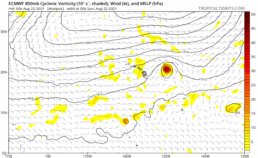
Shear is supposed to be out of the WSW/SW:

But on visible it looks like it's out of the ESE/SE: You can see the convection being pushed west and NW of the center.
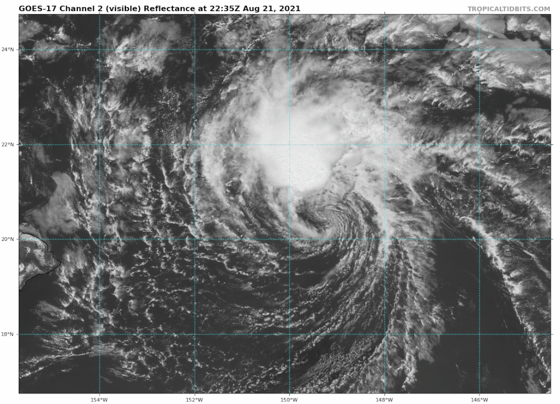
Weird.
That being said, it'll have a better chance at deeper convection in a few hours once its over 26C waters, and DMAX kicks in later on tonight.
But on visible it looks like it's out of the ESE/SE: You can see the convection being pushed west and NW of the center.
Weird.
That being said, it'll have a better chance at deeper convection in a few hours once its over 26C waters, and DMAX kicks in later on tonight.
1 likes
RIP Kobe Bryant
-
Sciencerocks
- Category 5

- Posts: 10186
- Age: 40
- Joined: Thu Jul 06, 2017 1:51 am
-
Kingarabian
- S2K Supporter
- Posts: 16367
- Joined: Sat Aug 08, 2009 3:06 am
- Location: Honolulu, Hawaii
Re: CPAC: LINDA - Post-Tropical
.DISCUSSION...
The flash flood watch for all Hawaiian islands remains in effect for
6am HST Sunday morning through 6am HST Tuesday morning. Overall
expectations remain largely unchanged. A general 2-4 inches, locally
6 inches is forecast over windward areas. Pockets up to 10 inches
will be possible if thunderstorms develop. The highest rain rates
are expected over interior Big Island during the day Sunday and
Monday and over the smaller islands on Monday. The center of
former TC Linda is churning away about 350 miles ENE of Hilo and
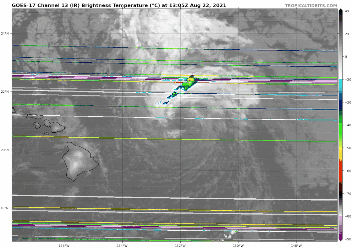
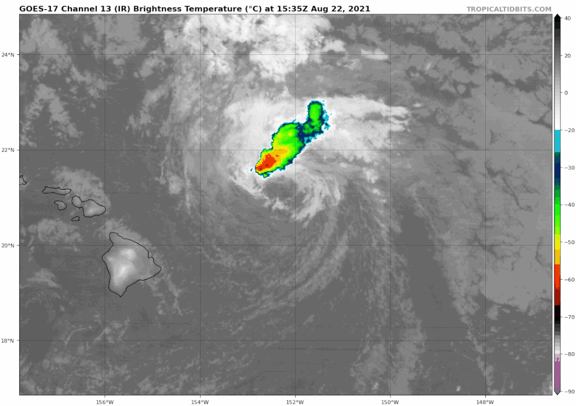
is slowly moving westward. Deep convection remains active along
its northern flank with convective tops on the order of 45-50kft
and persistent lightning activity within the more vigorous
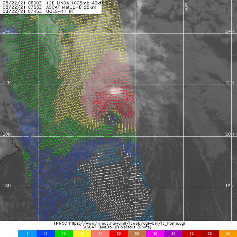
updrafts. A morning ASCAT pass showed sustained 25 kts encircling
the low with a solid corridor of sustained gales and near-gales
north of the center. All of this is to say the circulation remains
in tact and is demonstrating a very healthy appearance in all
available observations. The latest modeling continues to track the
low through the central part of the state and there is still the
expectation for a sharp gradient in impacts, the greatest
potential being within the northern and northwest sections of the
low. Given its proximity to the low itself, Oahu will be
particularly sensitive to further forecast adjustments.
The focus for tonight through late Sunday night will be on the
eastern half of the watch area, namely Big Island (particularly the
Hamakua Coast) and Maui. Cyclonic northeasterly flow around the
approaching low will funnel an increasing coverage of trade wind-
like showers onshore through tonight. Gradually increasing moisture
through the lowest 10kft will steadily erode the existing inversion
allowing windward showers to acquire greater coverage and intensity
during the latter half of the night and then persist through much of
Sunday. Although several inches of rain will be possible in these
areas during this time, the most intense rain rates will remain
offshore nearer the center of circulation. One possible exception
will be interior Big Island where diurnal convection will be capable
of producing heavy showers and a few thunderstorms during the peak
heating period both Sunday and Monday. Current modeling, with the
exception of the HRRR, confines the strongest portion of the wind
field well north of Maui and Big Island. Given the latest northward
nudge in track by the 18z GFS, confidence is moderate that a wind
advisory will not be needed for Maui County or Big Island. However,
it is worth noting that as wind backs to northwesterly on Sunday
afternoon, local effects may produce sustained northwest winds on
the order of 20-25 mph over portions of the Hamakua coastline.
Sunday night through Monday afternoon will feature a similar
evolution for Molokai through Kauai as trade wind showers increase in
coverage and intensity. Showers will penetrate leeward with
increasing efficiency as the column saturates through the lowest
15kft and PWATs increase to around 2 inches. It is during this time
that forecast soundings indicate opposing southwesterly flow in the
mid/upper levels around the eastern periphery of a broad upper-level
low. This raises the possibility for any deeper convection to become
anchored along windward terrain leading to locally increased flash
flood potential. Northeast wind along the lead edge of the
approaching low will also increase through the day Monday for Kauai
and possibly Oahu. The potential for a wind advisory on Monday will
be evaluated more closely as confidence increases in future forecast
packages.
Flash flood (and wind) potential will peak on Monday as mid-level
conditional instability increases over central and western portions
of the state coincident with the passage of the low. During this
time, the northern and northwestern sections of the low which are
presently supporting frequent thunderstorms well offshore, will move
through the area. Deep convection and isolated thunderstorms capable
of producing very high rain rates will be possible over the smaller
islands through the day Monday. At the same time, renewed diurnal
convection over the interior slopes of the Big Island will again b
The flash flood watch for all Hawaiian islands remains in effect for
6am HST Sunday morning through 6am HST Tuesday morning. Overall
expectations remain largely unchanged. A general 2-4 inches, locally
6 inches is forecast over windward areas. Pockets up to 10 inches
will be possible if thunderstorms develop. The highest rain rates
are expected over interior Big Island during the day Sunday and
Monday and over the smaller islands on Monday. The center of
former TC Linda is churning away about 350 miles ENE of Hilo and
is slowly moving westward. Deep convection remains active along
its northern flank with convective tops on the order of 45-50kft
and persistent lightning activity within the more vigorous
updrafts. A morning ASCAT pass showed sustained 25 kts encircling
the low with a solid corridor of sustained gales and near-gales
north of the center. All of this is to say the circulation remains
in tact and is demonstrating a very healthy appearance in all
available observations. The latest modeling continues to track the
low through the central part of the state and there is still the
expectation for a sharp gradient in impacts, the greatest
potential being within the northern and northwest sections of the
low. Given its proximity to the low itself, Oahu will be
particularly sensitive to further forecast adjustments.
The focus for tonight through late Sunday night will be on the
eastern half of the watch area, namely Big Island (particularly the
Hamakua Coast) and Maui. Cyclonic northeasterly flow around the
approaching low will funnel an increasing coverage of trade wind-
like showers onshore through tonight. Gradually increasing moisture
through the lowest 10kft will steadily erode the existing inversion
allowing windward showers to acquire greater coverage and intensity
during the latter half of the night and then persist through much of
Sunday. Although several inches of rain will be possible in these
areas during this time, the most intense rain rates will remain
offshore nearer the center of circulation. One possible exception
will be interior Big Island where diurnal convection will be capable
of producing heavy showers and a few thunderstorms during the peak
heating period both Sunday and Monday. Current modeling, with the
exception of the HRRR, confines the strongest portion of the wind
field well north of Maui and Big Island. Given the latest northward
nudge in track by the 18z GFS, confidence is moderate that a wind
advisory will not be needed for Maui County or Big Island. However,
it is worth noting that as wind backs to northwesterly on Sunday
afternoon, local effects may produce sustained northwest winds on
the order of 20-25 mph over portions of the Hamakua coastline.
Sunday night through Monday afternoon will feature a similar
evolution for Molokai through Kauai as trade wind showers increase in
coverage and intensity. Showers will penetrate leeward with
increasing efficiency as the column saturates through the lowest
15kft and PWATs increase to around 2 inches. It is during this time
that forecast soundings indicate opposing southwesterly flow in the
mid/upper levels around the eastern periphery of a broad upper-level
low. This raises the possibility for any deeper convection to become
anchored along windward terrain leading to locally increased flash
flood potential. Northeast wind along the lead edge of the
approaching low will also increase through the day Monday for Kauai
and possibly Oahu. The potential for a wind advisory on Monday will
be evaluated more closely as confidence increases in future forecast
packages.
Flash flood (and wind) potential will peak on Monday as mid-level
conditional instability increases over central and western portions
of the state coincident with the passage of the low. During this
time, the northern and northwestern sections of the low which are
presently supporting frequent thunderstorms well offshore, will move
through the area. Deep convection and isolated thunderstorms capable
of producing very high rain rates will be possible over the smaller
islands through the day Monday. At the same time, renewed diurnal
convection over the interior slopes of the Big Island will again b
0 likes
RIP Kobe Bryant
-
Kingarabian
- S2K Supporter
- Posts: 16367
- Joined: Sat Aug 08, 2009 3:06 am
- Location: Honolulu, Hawaii
Re: CPAC: LINDA - Post-Tropical
I wish they kept it up so we could see some HWRF and HMON runs...
0 likes
RIP Kobe Bryant
-
cycloneye
- Admin
- Posts: 149514
- Age: 69
- Joined: Thu Oct 10, 2002 10:54 am
- Location: San Juan, Puerto Rico
Re: CPAC: LINDA - Post-Tropical
Wow, in all that discussion, nothing about TS Linda as best track has.
0 likes
Visit the Caribbean-Central America Weather Thread where you can find at first post web cams,radars
and observations from Caribbean basin members Click Here
and observations from Caribbean basin members Click Here
-
EquusStorm
- Category 5
- Posts: 1649
- Age: 35
- Joined: Thu Nov 07, 2013 1:04 pm
- Location: Jasper, AL
- Contact:
Re: CPAC: LINDA - Post-Tropical
Between this and 16w being unclassified while it was in the basin, we're 0 for 2 this month there lol
2 likes
Colors of lost purpose on the canvas of irrelevance
Not a meteorologist, in fact more of an idiot than anything. You should probably check with the NHC or a local NWS office for official information.
Not a meteorologist, in fact more of an idiot than anything. You should probably check with the NHC or a local NWS office for official information.
-
Kingarabian
- S2K Supporter
- Posts: 16367
- Joined: Sat Aug 08, 2009 3:06 am
- Location: Honolulu, Hawaii
-
Kingarabian
- S2K Supporter
- Posts: 16367
- Joined: Sat Aug 08, 2009 3:06 am
- Location: Honolulu, Hawaii
Re: CPAC: LINDA - Post-Tropical
Last edited by Kingarabian on Sat Aug 21, 2021 10:15 pm, edited 1 time in total.
0 likes
RIP Kobe Bryant
-
cycloneye
- Admin
- Posts: 149514
- Age: 69
- Joined: Thu Oct 10, 2002 10:54 am
- Location: San Juan, Puerto Rico
Re: CPAC: LINDA - Post-Tropical
I would have changed the title of this thread to Tropical Storm Linda a while back but without oficial guideline I have to leave it as it is now.
4 likes
Visit the Caribbean-Central America Weather Thread where you can find at first post web cams,radars
and observations from Caribbean basin members Click Here
and observations from Caribbean basin members Click Here
-
Yellow Evan
- Professional-Met
- Posts: 16240
- Age: 27
- Joined: Fri Jul 15, 2011 12:48 pm
- Location: Henderson, Nevada/Honolulu, HI
- Contact:
-
Kingarabian
- S2K Supporter
- Posts: 16367
- Joined: Sat Aug 08, 2009 3:06 am
- Location: Honolulu, Hawaii
Re: CPAC: LINDA - Post-Tropical
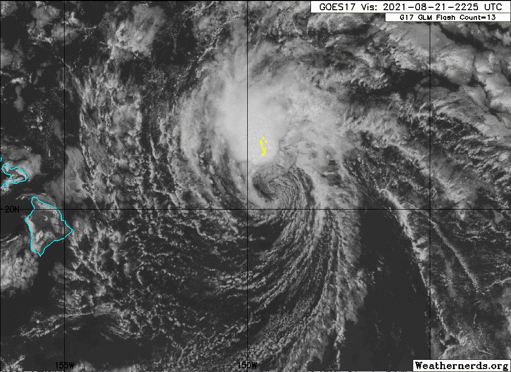
Convection waning. Still needs to get to 26C waters to see what it can or can't do.
0 likes
RIP Kobe Bryant
-
Kingarabian
- S2K Supporter
- Posts: 16367
- Joined: Sat Aug 08, 2009 3:06 am
- Location: Honolulu, Hawaii
Re: CPAC: LINDA - Post-Tropical
Center is finally over 26C waters. Will see what it's got tomorrow or if the upper level winds are gonna win out again.
That being said, latest ASCAT pass continues to show a healthy amount of TS force winds in the northern quads of the system. Even some 35kt barbs. This is still a 40kt system.
0 likes
RIP Kobe Bryant
-
Kingarabian
- S2K Supporter
- Posts: 16367
- Joined: Sat Aug 08, 2009 3:06 am
- Location: Honolulu, Hawaii
Re: CPAC: LINDA - Post-Tropical
This will have to hit the islands for any sort of TS impacts. Latest GFS and Euro shifted north and now show an Oahu hit. Any more shifts north and this thing will likely clear the islands. Though the Canadian/UKMET solutions are still south.

0 likes
RIP Kobe Bryant
-
Yellow Evan
- Professional-Met
- Posts: 16240
- Age: 27
- Joined: Fri Jul 15, 2011 12:48 pm
- Location: Henderson, Nevada/Honolulu, HI
- Contact:
-
Kingarabian
- S2K Supporter
- Posts: 16367
- Joined: Sat Aug 08, 2009 3:06 am
- Location: Honolulu, Hawaii
Re: CPAC: LINDA - Post-Tropical
Last edited by Kingarabian on Sun Aug 22, 2021 10:35 am, edited 1 time in total.
0 likes
RIP Kobe Bryant
-
Kingarabian
- S2K Supporter
- Posts: 16367
- Joined: Sat Aug 08, 2009 3:06 am
- Location: Honolulu, Hawaii
Re: CPAC: LINDA - Post-Tropical
Discussion
A flash flood watch remains in effect for all Hawaiian Islands through 6am HST Tuesday morning. The overall expectations remain largely unchanged, that is generally 2-4 inches, with locally higher amounts, to 6 inches is forecast for the windward areas. Locally up to 10 inches is possible should thunderstorms develop. The weather will be deteriorating east of Kauai today, particularly the Big Island and Maui later this morning, then the rest of Maui County this afternoon, followed by Oahu tonight. It could be an all day event for Oahu on Monday, while the weather spreads to Kauai Monday afternoon. Most of the unsettled weather should be west of Kauai by sunrise Tuesday, with a return to a more typical trade wind weather for the rest of the week.
The path of Linda's remnants is critical as far as winds are concern. Should Linda cuts across leeward Maui County, the islands will be on the windy side of the system. Should Linda stays slightly north of the smaller islands, it will not be so windy. The current wind grids have breezy east to northeast winds traversing islands and the windward waters. So, a Wind Advisory is not out of the question at this time.
The current forecast has Linda's circulation reaching Maui shortly after midnight tonight, and passing just south of Oahu Monday afternoon. From that point on, the circulation of Linda becomes a trough as it passes Kauai Monday night.
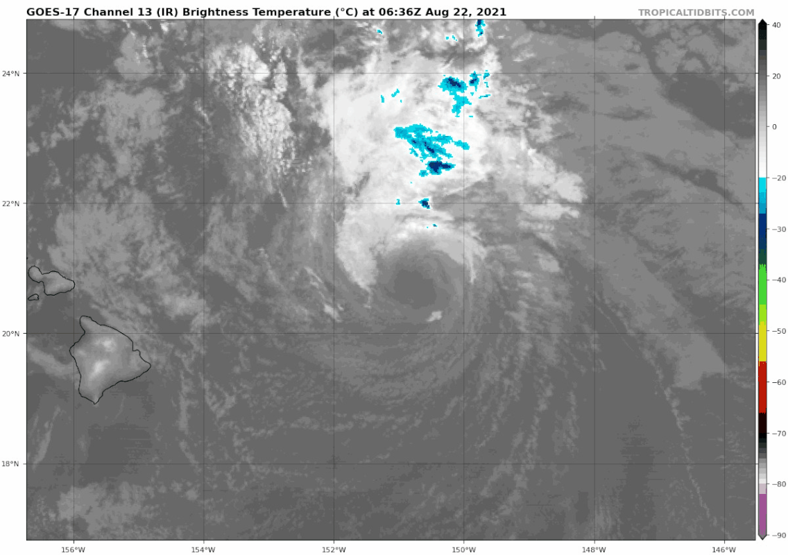
As of 200 am HST, satellite imagery shows the circulation of former TC Linda about 225 miles ENE of Hilo. It is moving west at 10 mph. The remnants of Linda has been voided of any deep convection since Saturday afternoon. So far, the trade showers have been scattered, with windward Big Island the wettest, and Oahu and Kauai, the driest, although radar is picking up a few trade showers just upwind of Oahu.
A flash flood watch remains in effect for all Hawaiian Islands through 6am HST Tuesday morning. The overall expectations remain largely unchanged, that is generally 2-4 inches, with locally higher amounts, to 6 inches is forecast for the windward areas. Locally up to 10 inches is possible should thunderstorms develop. The weather will be deteriorating east of Kauai today, particularly the Big Island and Maui later this morning, then the rest of Maui County this afternoon, followed by Oahu tonight. It could be an all day event for Oahu on Monday, while the weather spreads to Kauai Monday afternoon. Most of the unsettled weather should be west of Kauai by sunrise Tuesday, with a return to a more typical trade wind weather for the rest of the week.
The path of Linda's remnants is critical as far as winds are concern. Should Linda cuts across leeward Maui County, the islands will be on the windy side of the system. Should Linda stays slightly north of the smaller islands, it will not be so windy. The current wind grids have breezy east to northeast winds traversing islands and the windward waters. So, a Wind Advisory is not out of the question at this time.
The current forecast has Linda's circulation reaching Maui shortly after midnight tonight, and passing just south of Oahu Monday afternoon. From that point on, the circulation of Linda becomes a trough as it passes Kauai Monday night.
As of 200 am HST, satellite imagery shows the circulation of former TC Linda about 225 miles ENE of Hilo. It is moving west at 10 mph. The remnants of Linda has been voided of any deep convection since Saturday afternoon. So far, the trade showers have been scattered, with windward Big Island the wettest, and Oahu and Kauai, the driest, although radar is picking up a few trade showers just upwind of Oahu.
0 likes
RIP Kobe Bryant
-
Yellow Evan
- Professional-Met
- Posts: 16240
- Age: 27
- Joined: Fri Jul 15, 2011 12:48 pm
- Location: Henderson, Nevada/Honolulu, HI
- Contact:
-
Kingarabian
- S2K Supporter
- Posts: 16367
- Joined: Sat Aug 08, 2009 3:06 am
- Location: Honolulu, Hawaii
Who is online
Users browsing this forum: No registered users and 21 guests