Bahamas area of interest
Moderator: S2k Moderators
Forum rules

The posts in this forum are NOT official forecasts and should not be used as such. They are just the opinion of the poster and may or may not be backed by sound meteorological data. They are NOT endorsed by any professional institution or STORM2K. For official information, please refer to products from the National Hurricane Center and National Weather Service.


Bahamas area of interest
Not sure if its an ULL or an AEW that hasn't been mentioned, but it looks interesting on IR
1 likes

Re: Bahamas area of interest
I was just about to start a thread on this as well. Woke up this morning and saw the satellite. Looks like a broad area of cyclonic turning just east of the Bahamas.
https://www.star.nesdis.noaa.gov/GOES/c ... &length=24
https://www.star.nesdis.noaa.gov/GOES/c ... &length=24
2 likes
-
AlphaToOmega
- Category 5

- Posts: 1448
- Joined: Sat Jun 26, 2021 10:51 am
- Location: Somewhere in Massachusetts
Re: Bahamas area of interest
This does not seem to have ensemble support from either the GEFS or ECENS.
0 likes
Re: Bahamas area of interest
AlphaToOmega wrote:This does not seem to have ensemble support from either the GEFS or ECENS.
They have it moving onshore too quickly to develop it seems. Just something to keep an eye on waiting for the main show to start later this week.
0 likes
-
AutoPenalti
- Category 5
- Posts: 4091
- Age: 29
- Joined: Mon Aug 17, 2015 4:16 pm
- Location: Ft. Lauderdale, Florida
Re: Bahamas area of interest
It's puking out outflow boundaries so it's battling some dry air, otherwise this would probably be a marked area.
3 likes
The posts in this forum are NOT official forecasts and should not be used as such. They are just the opinion of the poster and may or may not be backed by sound meteorological data. They are NOT endorsed by any professional institution or STORM2K. For official information, please refer to products from the NHC and NWS.
Model Runs Cheat Sheet:
GFS (5:30 AM/PM, 11:30 AM/PM)
HWRF, GFDL, UKMET, NAVGEM (6:30-8:00 AM/PM, 12:30-2:00 AM/PM)
ECMWF (1:45 AM/PM)
TCVN is a weighted averaged
-
toad strangler

- S2K Supporter

- Posts: 4546
- Joined: Sun Jul 28, 2013 3:09 pm
- Location: Earth
- Contact:
Re: Bahamas area of interest
I saw this earlier but new it was a turd being nobody here was on it yet 
0 likes
My Weather Station
https://www.wunderground.com/dashboard/pws/KFLPORTS603
https://www.wunderground.com/dashboard/pws/KFLPORTS603
-
wxman22

- Category 5
- Posts: 2007
- Joined: Mon Jan 30, 2006 12:39 am
- Location: Wichita Falls, TX
- Contact:
Re: Bahamas area of interest
This is the inverted trough the models have been showing getting into the gulf later this week.
0 likes
-
AutoPenalti
- Category 5
- Posts: 4091
- Age: 29
- Joined: Mon Aug 17, 2015 4:16 pm
- Location: Ft. Lauderdale, Florida
Re: Bahamas area of interest
wxman22 wrote:This is the inverted trough the models have been showing getting into the gulf later this week.
Yes, this same wave may interact with future Ida.

0 likes
The posts in this forum are NOT official forecasts and should not be used as such. They are just the opinion of the poster and may or may not be backed by sound meteorological data. They are NOT endorsed by any professional institution or STORM2K. For official information, please refer to products from the NHC and NWS.
Model Runs Cheat Sheet:
GFS (5:30 AM/PM, 11:30 AM/PM)
HWRF, GFDL, UKMET, NAVGEM (6:30-8:00 AM/PM, 12:30-2:00 AM/PM)
ECMWF (1:45 AM/PM)
TCVN is a weighted averaged
-
AnnularCane

- S2K Supporter
- Posts: 2964
- Joined: Thu Jun 08, 2006 9:18 am
- Location: Wytheville, VA
Re: Bahamas area of interest
AutoPenalti wrote:It's puking out outflow boundaries so it's battling some dry air, otherwise this would probably be a marked area.
Maybe Pepto Bismol will help?
That does seem to bear a strong resemblance to an African wave. Satellite-wise anyway.
1 likes
"But it never rained rain. It never snowed snow. And it never blew just wind. It rained things like soup and juice. It snowed mashed potatoes and green peas. And sometimes the wind blew in storms of hamburgers." -- Judi Barrett, Cloudy with a Chance of Meatballs
Re: Bahamas area of interest
wxman22 wrote:This is the inverted trough the models have been showing getting into the gulf later this week.
Looks like the vorticity splits with part of it going NW inland and the rest heading into the gulf
0 likes
-
Category5Kaiju

- Category 5
- Posts: 4346
- Joined: Thu Dec 24, 2020 12:45 pm
- Location: Seattle during the summer, Phoenix during the winter
Re: Bahamas area of interest
Lots of deep layer shear around it currently; it would be surprising to me if it does form, but you never know..
0 likes
Unless explicitly stated, all information in my posts is based on my own opinions and observations. Tropical storms and hurricanes can be extremely dangerous. Refer to an accredited weather research agency or meteorologist if you need to make serious decisions regarding an approaching storm.

Re: Bahamas area of interest
Good looking ULL heading towards Florida the east coast can use the rain.
2 likes
-
toad strangler
- S2K Supporter
- Posts: 4546
- Joined: Sun Jul 28, 2013 3:09 pm
- Location: Earth
- Contact:
Re: Bahamas area of interest
boca wrote:Good looking ULL heading towards Florida the east coast can use the rain.
This will be our landfall from the East this year
1 likes
My Weather Station
https://www.wunderground.com/dashboard/pws/KFLPORTS603
https://www.wunderground.com/dashboard/pws/KFLPORTS603
Re: Bahamas area of interest
toad strangler wrote:boca wrote:Good looking ULL heading towards Florida the east coast can use the rain.
This will be our landfall from the East this year
I love that answer because either the storms go underneath us or the curve north in the Bahamas.
0 likes

Re: Bahamas area of interest
The evening convection converging towards an apparent center gives the illusion of a warm core developing.
Must be an illusion though since there is not much model support.
Must be an illusion though since there is not much model support.
0 likes

Re: Bahamas area of interest
Nimbus wrote:The evening convection converging towards an apparent center gives the illusion of a warm core developing.
Must be an illusion though since there is not much model support.
There does seem to be a wave axis there, the southern end of it is visible south of Aklins Island in the Bahamas.
0 likes
The above post is not official and should not be used as such. It is the opinion of the poster and may or may not be backed by sound meteorological data. It is not endorsed by any professional institution or storm2k.org. For official information, please refer to the NHC and NWS products.
-
Stormcenter
- S2K Supporter
- Posts: 6689
- Joined: Wed Sep 03, 2003 11:27 am
- Location: Houston, TX
Re: Bahamas area of interest
Forget the model support that Is a significant looking
whatever headed toward Florida and then the Gulf.
whatever headed toward Florida and then the Gulf.
1 likes
Re: Bahamas area of interest
Stormcenter wrote:Forget the model support that Is a significant looking
whatever headed toward Florida and then the Gulf.
Organized or not, looks like a lot of weather incoming for the Bahamas and SFLA
https://radars.bahamasweather.org.bs/
0 likes
-
AlphaToOmega
- Category 5
- Posts: 1448
- Joined: Sat Jun 26, 2021 10:51 am
- Location: Somewhere in Massachusetts
Re: Bahamas area of interest
For the forecast, a surface trough will move into the eastern
Gulf Wed night into Thu morning, bringing fresh E winds.
Otherwise, high pressure pressure will dominate the basin through
Fri, producing mainly gentle to moderate E to SE winds. Fresh
winds will pulse west of the Yucatan Peninsula tonight and again
Wed night.
Gulf Wed night into Thu morning, bringing fresh E winds.
Otherwise, high pressure pressure will dominate the basin through
Fri, producing mainly gentle to moderate E to SE winds. Fresh
winds will pulse west of the Yucatan Peninsula tonight and again
Wed night.
0 likes
-
AlphaToOmega
- Category 5
- Posts: 1448
- Joined: Sat Jun 26, 2021 10:51 am
- Location: Somewhere in Massachusetts
Re: Bahamas area of interest
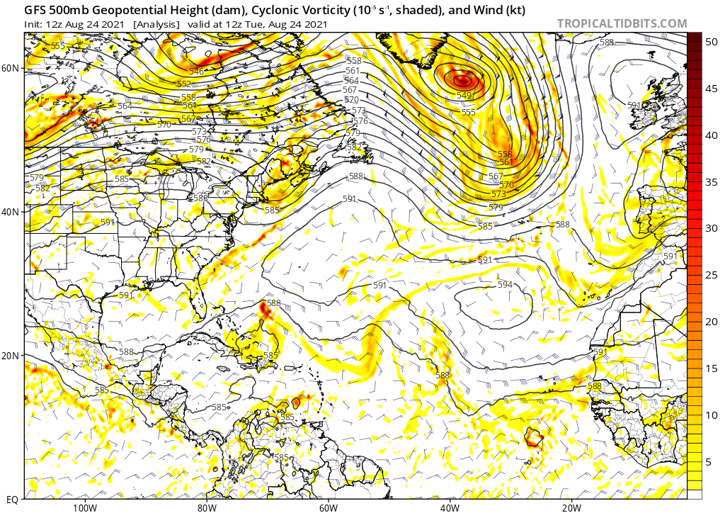
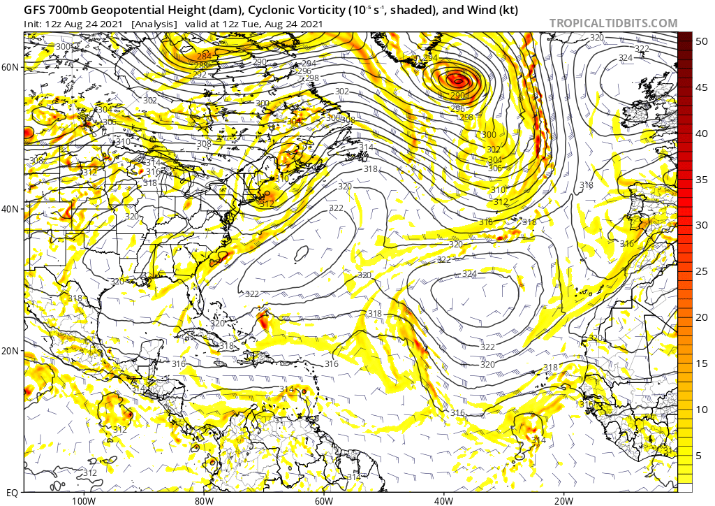
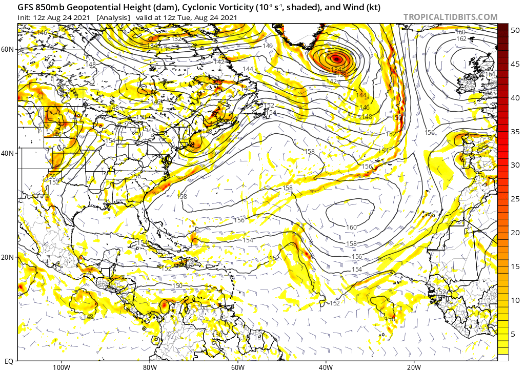
This system has a lot of upper level (500 mb) and mid level (700 mb) vorticity associated with it, but it does not have much lower level (850 mb) vorticity.
0 likes
Who is online
Users browsing this forum: mixedDanilo.E and 169 guests