

Tropical Wave over the Central Caribbean (Is Invest 99L)
Moderator: S2k Moderators
Forum rules

The posts in this forum are NOT official forecasts and should not be used as such. They are just the opinion of the poster and may or may not be backed by sound meteorological data. They are NOT endorsed by any professional institution or STORM2K. For official information, please refer to products from the National Hurricane Center and National Weather Service.
Re: Tropical Wave over the Eastern Caribbean
CMC is very close to the latest Euro in location, and would also dump a lot of rain over central Texas.
1 likes
Personal Forecast Disclaimer:
The posts in this forum are NOT official forecast and should not be used as such. They are just the opinion of the poster and may or may not be backed by sound meteorological data. They are NOT endorsed by any professional institution or storm2k.org. For official information, please refer to the NHC and NWS products.
The posts in this forum are NOT official forecast and should not be used as such. They are just the opinion of the poster and may or may not be backed by sound meteorological data. They are NOT endorsed by any professional institution or storm2k.org. For official information, please refer to the NHC and NWS products.

Re: Tropical Wave over the Eastern Caribbean
The 12z GFS, CMC, and ICON are all targeting the southern Texas coast. GFS has multiple competing vortices, while the CMC and ICON both quickly favor the northern lobe by the time it’s in the Yucatán Channel. The rate of organization and where the LLC tries to consolidate will mean the difference between a sloppy TS and a potent hurricane at landfall.
2 likes
Irene '11 Sandy '12 Hermine '16 5/15/2018 Derecho Fay '20 Isaias '20 Elsa '21 Henri '21 Ida '21
I am only a meteorology enthusiast who knows a decent amount about tropical cyclones. Look to the professional mets, the NHC, or your local weather office for the best information.
I am only a meteorology enthusiast who knows a decent amount about tropical cyclones. Look to the professional mets, the NHC, or your local weather office for the best information.
Re: Tropical Wave over the Eastern Caribbean
12Z CMC has a pretty large windfield power outages would be widespread even quite a bit to the east of where it makes landfall.
0 likes
Re: Tropical Wave over the Eastern Caribbean
aspen wrote:The 12z GFS, CMC, and ICON are all targeting the southern Texas coast. GFS has multiple competing vortices, while the CMC and ICON both quickly favor the northern lobe by the time it’s in the Yucatán Channel. The rate of organization and where the LLC tries to consolidate will mean the difference between a sloppy TS and a potent hurricane at landfall.
I think this is why wxman commented, somewhat cryptic, this morning about not ruling out Texas. That angle of approach too will determine whether Houston sees a bunch of rain versus San Antonio. Most of the recent runs favor a San Antonio rainfall event after landfall...for now.
2 likes
Personal Forecast Disclaimer:
The posts in this forum are NOT official forecast and should not be used as such. They are just the opinion of the poster and may or may not be backed by sound meteorological data. They are NOT endorsed by any professional institution or storm2k.org. For official information, please refer to the NHC and NWS products.
The posts in this forum are NOT official forecast and should not be used as such. They are just the opinion of the poster and may or may not be backed by sound meteorological data. They are NOT endorsed by any professional institution or storm2k.org. For official information, please refer to the NHC and NWS products.
-
Rgv20

- S2K Supporter

- Posts: 2466
- Age: 39
- Joined: Wed Jan 05, 2011 5:42 pm
- Location: Edinburg/McAllen Tx
Re: Tropical Wave over the Eastern Caribbean
12zUKMET Text Output...Has a TC South East of Brownsville by Monday morning. Looks like all the major models are increasing the odds of a TC making landfall in Texas early next week.
NEW TROPICAL STORM FORECAST TO DEVELOP AFTER 114 HOURS
FORECAST POSITION AT T+114 : 20.0N 91.8W
VERIFYING TIME POSITION STRENGTH TENDENCY
-------------- -------- -------- --------
12UTC 29.08.2021 20.8N 92.6W WEAK LITTLE CHANGE
00UTC 30.08.2021 22.8N 94.9W WEAK LITTLE CHANGE
12UTC 30.08.2021 23.9N 96.6W MODERATE INTENSIFYING SLIGHTLY
2 likes
The following post is NOT an official forecast and should not be used as such. It is just the opinion of the poster and may or may not be backed by sound meteorological data. It is NOT endorsed by any professional institution including storm2k.org For Official Information please refer to the NHC and NWS products.
Re: Tropical Wave over the Eastern Caribbean
Rgv20 wrote:12zUKMET Text Output...Has a TC South East of Brownsville by Monday morning. Looks like all the major models are increasing the odds of a TC making landfall in Texas early next week.
NEW TROPICAL STORM FORECAST TO DEVELOP AFTER 114 HOURS
FORECAST POSITION AT T+114 : 20.0N 91.8W
VERIFYING TIME POSITION STRENGTH TENDENCY
-------------- -------- -------- --------
12UTC 29.08.2021 20.8N 92.6W WEAK LITTLE CHANGE
00UTC 30.08.2021 22.8N 94.9W WEAK LITTLE CHANGE
12UTC 30.08.2021 23.9N 96.6W MODERATE INTENSIFYING SLIGHTLY
Yeah the entire Texas coast from Brownsville all the way to Port Arthur need to be paying attention to this.
1 likes
-
HoustonFrog
- Tropical Depression

- Posts: 98
- Joined: Thu Jun 04, 2020 1:49 pm
Re: Tropical Wave over the Eastern Caribbean
So when will this become an "active" storm/invest?
0 likes
-
ColdMiser123

- Professional-Met

- Posts: 905
- Age: 29
- Joined: Mon Sep 26, 2016 3:26 pm
- Location: Northeast US
Re: Tropical Wave over the Eastern Caribbean
Rgv20 wrote:12zUKMET Text Output...Has a TC South East of Brownsville by Monday morning. Looks like all the major models are increasing the odds of a TC making landfall in Texas early next week.
NEW TROPICAL STORM FORECAST TO DEVELOP AFTER 114 HOURS
FORECAST POSITION AT T+114 : 20.0N 91.8W
VERIFYING TIME POSITION STRENGTH TENDENCY
-------------- -------- -------- --------
12UTC 29.08.2021 20.8N 92.6W WEAK LITTLE CHANGE
00UTC 30.08.2021 22.8N 94.9W WEAK LITTLE CHANGE
12UTC 30.08.2021 23.9N 96.6W MODERATE INTENSIFYING SLIGHTLY
Looks to be the first time the UKMET is showing anything at all for this disturbance, a fluid situation with models still figuring out what will happen.
Last edited by ColdMiser123 on Tue Aug 24, 2021 12:10 pm, edited 1 time in total.
1 likes
B.S., M.S., Meteorology & Atmospheric Science
Re: Tropical Wave over the Eastern Caribbean
HoustonFrog wrote:So when will this become an "active" storm/invest?
Probably on either Wednesday or Thursday.
1 likes

Re: Tropical Wave over the Eastern Caribbean
I don’t think he was being cryptic lol but making sure it was known. Model runs trending up the MX TX coast. Harvey type storm minus the stall cannot be discounted. The 31C ssts would blow this up…that large wind field from the CMC is discomforting.
0 likes
Re: Tropical Wave over the Eastern Caribbean
IcyTundra wrote:HoustonFrog wrote:So when will this become an "active" storm/invest?
Probably on either Wednesday or Thursday.
Agree with that time frame.
0 likes
Re: Tropical Wave over the Eastern Caribbean
Y’all are leaving out the NAVGEM 06Z run north of matagorda!!  Got to give it some love also.
0 likes


Re: Tropical Wave over the Eastern Caribbean
Local TV mets in Houston are talking this up now. Lots of comparisons of American and European model runs during weather segments. Saying maybe even a possibility it could be a slow mover. We know plenty about slow moving systems and tons of rain and could certainly do without that.
0 likes

Re: Tropical Wave over the Eastern Caribbean
Well defined 700 mb wave signature.
Mid-level (500 mb) vort becoming defined.
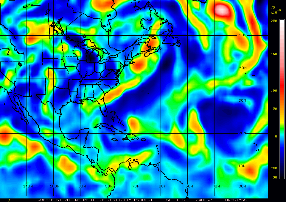
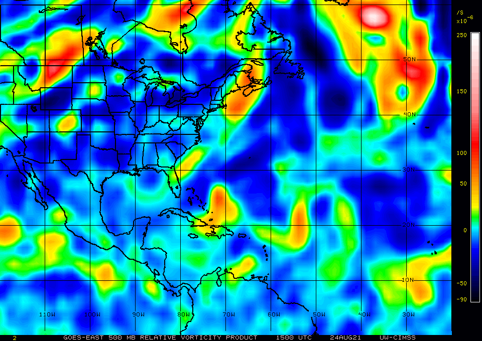
Mid-level (500 mb) vort becoming defined.
1 likes
-
Category5Kaiju

- Category 5

- Posts: 4346
- Joined: Thu Dec 24, 2020 12:45 pm
- Location: Seattle during the summer, Phoenix during the winter
Re: Tropical Wave over the Eastern Caribbean
Whatever happens in the end, I really hope Texas does not find itself facing a hurricane threat later next week, let alone a major. Texas has already been through a lot with Harvey, and another big hurricane landfall would simply add more misery and suffering.
0 likes
Unless explicitly stated, all information in my posts is based on my own opinions and observations. Tropical storms and hurricanes can be extremely dangerous. Refer to an accredited weather research agency or meteorologist if you need to make serious decisions regarding an approaching storm.
-
Frank P
- S2K Supporter
- Posts: 2779
- Joined: Fri Aug 29, 2003 10:52 am
- Location: Biloxi Beach, Ms
- Contact:
Re: Tropical Wave over the Eastern Caribbean
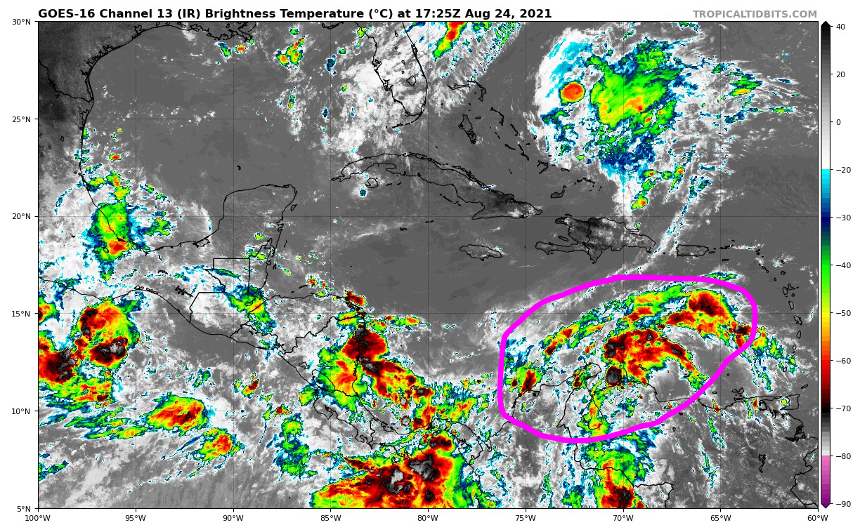
Sat presentation starting to slightly improve this afternoon… hints of broad banding evident on the loops.
1 likes
Re: Tropical Wave over the Eastern Caribbean
Strong and wide area of convection firing along a sharp shear axis.
This time of year, setups like this can create a multiple number of hot towers that can push vorticity down to the surface and expand the upper troposphere vertically.
 \]]
\]]
 keyboard asus error
This time of year, setups like this can create a multiple number of hot towers that can push vorticity down to the surface and expand the upper troposphere vertically.
\]]keyboard asus error
3 likes
-
cycloneye

- Admin

- Posts: 149719
- Age: 69
- Joined: Thu Oct 10, 2002 10:54 am
- Location: San Juan, Puerto Rico
Re: Tropical Wave over the Central Caribbean
A broad area of low pressure is expected to form over the
southwestern Caribbean Sea in a couple of days from a tropical wave
currently located over the central Caribbean Sea. Environmental
conditions are forecast to be conducive for development of the low
if it remains over water, and a tropical depression could form late
this week or this weekend while the system moves northwestward over
the northwestern Caribbean Sea, across the Yucatan Peninsula of
Mexico, and into the southwestern Gulf of Mexico by Sunday.
* Formation chance through 48 hours...low...10 percent.
* Formation chance through 5 days...medium...60 percent.
0 likes
Visit the Caribbean-Central America Weather Thread where you can find at first post web cams,radars
and observations from Caribbean basin members Click Here
and observations from Caribbean basin members Click Here
-
Clearcloudz

- Category 2

- Posts: 540
- Joined: Sun Jun 10, 2018 1:46 pm
- Location: Rosenberg TX
Re: Tropical Wave over the Central Caribbean
Wow very strong 12z CMC Run. I'm willing to predict EURO shows a major in to Texas on this run as well. CMC and euro tend to correlate a lot.
Last edited by Clearcloudz on Tue Aug 24, 2021 12:56 pm, edited 1 time in total.
0 likes
Who is online
Users browsing this forum: No registered users and 129 guests