SoupBone wrote:toad strangler wrote:SoupBone wrote:Where do I sign up for the paid version of the Euro? I want to see the 18Z.
Weatherbell??
I don't know if they have it or not.
Weather.us (cheapest) and weathermodels both have the 6/18z euro.
Moderator: S2k Moderators
SoupBone wrote:toad strangler wrote:SoupBone wrote:Where do I sign up for the paid version of the Euro? I want to see the 18Z.
Weatherbell??
I don't know if they have it or not.


Kingarabian wrote:cycloneye wrote:Fnmoc Is a good source from the Navy. ATCF comming shortly.
https://www.fnmoc.navy.mil/tcweb/cgi-bin/tc_home.cgi
Yeah they sometimes go ahead of ATCF but 99L should be in soon.

SoupBone wrote:
So is that where they will initialize models?


The long term forecast gets rather...complicated. We kick off the
extended with the upper ridge slowly shifting off to the northeast.
This will open the door for an inverted trough to slide across the
Gulf while bringing some deeper moisture into the region. Isolated
to scattered showers and thunderstorms will be possible daily as we
head into the weekend.
All eyes will be on the tropics over the course of the weekend. The
NHC is currently monitoring an area of potential development (60%
chance) over the Caribbean. This feature is expected to develop into
a low pressure system while heading into the SW Gulf by Sunday. The
aforementioned ridge looks to weaken Saturday and Sunday as an upper
level shortwave dips across the Northern Plains. This would provide
a window for this disturbance to move northwest across the Gulf.
Recent runs of the GFS/CMC/ICON are all steering this system towards
the Middle Texas coast. With that said, the recent ECMWF take it to
the Louisiana cost so there is still some spread with this system.
Track and intensity will be narrowed in over the next several days.
Regardless of the eventual track, deep tropical moisture will arrive
late this weekend with PWATs skyrocketing to the 2.7-2.9" range.
This will allow for widespread showers and thunderstorms with
locally heavy rainfall possible. As expected, models are trending
towards a heavy rainfall event but we can`t pin down any numbers at
this time as it will be heavily dependent on the track. In addition
to the heavy rainfall, we can expect an increase in our rip current
and coastal flooding threats as hazardous conditions develop over
our waters.
Taking a quick look at temperatures, we will stay warm through the
weekend with heat indices generally in the 105-109 range. Increasing
rain chances/cloud cover this weekend will result in temps a few
degrees cooler heading into early next week.
REMINDER: it is never too early to prepare as we head into the peak
of Hurricane Season. All are urged to stay alert and keep up with
the latest information in regards to the tropics at NHC.noaa.gov

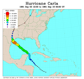
beoumont wrote:It's about time for another Carla, don't ya think?
[url]https://i.postimg.cc/XYVFLkLd/Carla.png [/url]free image sharing
grapealcoholic wrote:beoumont wrote:It's about time for another Carla, don't ya think?
[url]https://i.postimg.cc/XYVFLkLd/Carla.png [/url]free image sharing
Got a feeling Louisiana isn't quite out of the woods yet


SoupBone wrote:For those that are curious, the Yucatan Peninsula offers little to no elevation to disrupt an inner core.
https://i.imgur.com/7PetA8k.jpeg

Iceresistance wrote:SoupBone wrote:For those that are curious, the Yucatan Peninsula offers little to no elevation to disrupt an inner core.
https://i.imgur.com/7PetA8k.jpeg
Hurricane Grace just the week before demonstrated this . . .

SconnieCane wrote:Iceresistance wrote:SoupBone wrote:For those that are curious, the Yucatan Peninsula offers little to no elevation to disrupt an inner core.
https://i.imgur.com/7PetA8k.jpeg
Hurricane Grace just the week before demonstrated this . . .
I feel like Wilma 2005 weakened rather substantially over the Yucatan...but it slowed and meandered over land for some time, correct? It had also already come down quite a bit from its 882 mb peak by the time of landfall, and it was still able to re-intensify into a strong Cat. 3 for the Florida landfall, with some help from a favorable trough interaction.


Users browsing this forum: No registered users and 200 guests