

ATL: JULIAN - Post-Tropical
Moderator: S2k Moderators
Re: ATL: INVEST 97L - Discussion
An explosion of convection at the end... quite surprising since this wasn't expected to get going until later this week, and it was a naked swirl this morning.
0 likes
-
AlphaToOmega
- Category 5

- Posts: 1448
- Joined: Sat Jun 26, 2021 10:51 am
- Location: Somewhere in Massachusetts
-
Sciencerocks
- Category 5
- Posts: 10186
- Age: 40
- Joined: Thu Jul 06, 2017 1:51 am
-
AlphaToOmega
- Category 5
- Posts: 1448
- Joined: Sat Jun 26, 2021 10:51 am
- Location: Somewhere in Massachusetts
Re: ATL: INVEST 97L - Discussion
A trough of low pressure located over the central Atlantic about
600 miles east of Bermuda continues to produce disorganized showers
and thunderstorms. Environmental conditions are forecast to be
generally conducive for development, and a tropical depression
is likely to form late this week or this weekend while the system
moves slowly eastward at 5 to 10 mph.
* Formation chance through 48 hours...medium...40 percent.
* Formation chance through 5 days...high...70 percent.
0 likes
-
AlphaToOmega
- Category 5
- Posts: 1448
- Joined: Sat Jun 26, 2021 10:51 am
- Location: Somewhere in Massachusetts
Re: ATL: INVEST 97L - Discussion
I cannot believe how badly the models are performing with this system! First they show development; then they show no development. The ECMWF and ICON show development, but the GFS and CMC show no development. Have the models always been this awful, or is this a new thing?
0 likes
-
Sciencerocks
- Category 5
- Posts: 10186
- Age: 40
- Joined: Thu Jul 06, 2017 1:51 am
-
tolakram
- Admin

- Posts: 20186
- Age: 62
- Joined: Sun Aug 27, 2006 8:23 pm
- Location: Florence, KY (name is Mark)
Re: ATL: INVEST 97L - Discussion
AlphaToOmega wrote:I cannot believe how badly the models are performing with this system! First they show development; then they show no development. The ECMWF and ICON show development, but the GFS and CMC show no development. Have the models always been this awful, or is this a new thing?
What type of plots are you looking at? Vorticity is your friend here, rather than an MSLP plot. Take this to the model thread?
0 likes
M a r k
- - - - -
Join us in chat: Storm2K Chatroom Invite. Android and IOS apps also available.
The posts in this forum are NOT official forecasts and should not be used as such. Posts are NOT endorsed by any professional institution or STORM2K.org. For official information and forecasts, please refer to NHC and NWS products.
-
cycloneye

- Admin
- Posts: 149550
- Age: 69
- Joined: Thu Oct 10, 2002 10:54 am
- Location: San Juan, Puerto Rico
Re: ATL: INVEST 97L - Discussion
An elongated area of low pressure located over the central Atlantic
about 600 miles east of Bermuda continues to produce disorganized
showers and thunderstorms. Environmental conditions are forecast
to be generally conducive for development, and a tropical depression
is likely to form this weekend. The system is expected to move
slowly eastward during the next day or two, but a faster
northeastward motion is forecast to begin on Sunday.
* Formation chance through 48 hours...medium...50 percent.
* Formation chance through 5 days...high...70 percent.
0 likes
Visit the Caribbean-Central America Weather Thread where you can find at first post web cams,radars
and observations from Caribbean basin members Click Here
and observations from Caribbean basin members Click Here

Re: ATL: INVEST 97L - Discussion
AlphaToOmega wrote:I cannot believe how badly the models are performing with this system! First they show development; then they show no development. The ECMWF and ICON show development, but the GFS and CMC show no development. Have the models always been this awful, or is this a new thing?
It's a small system so its entirely possible they aren't resolving it properly.
0 likes
The above post is not official and should not be used as such. It is the opinion of the poster and may or may not be backed by sound meteorological data. It is not endorsed by any professional institution or storm2k.org. For official information, please refer to the NHC and NWS products.
-
Sciencerocks
- Category 5
- Posts: 10186
- Age: 40
- Joined: Thu Jul 06, 2017 1:51 am
-
cycloneye
- Admin
- Posts: 149550
- Age: 69
- Joined: Thu Oct 10, 2002 10:54 am
- Location: San Juan, Puerto Rico
Re: ATL: INVEST 97L - Discussion
An elongated area of low pressure located over the central Atlantic
about 650 miles east of Bermuda is producing disorganized showers
and thunderstorms. Environmental conditions are forecast to be
generally conducive for development, and a tropical depression is
likely to form over the weekend. The system is expected to move
slowly eastward during the next day or two, but a faster
northeastward motion is forecast to begin on Sunday.
* Formation chance through 48 hours...medium...50 percent.
* Formation chance through 5 days...high...70 percent.
0 likes
Visit the Caribbean-Central America Weather Thread where you can find at first post web cams,radars
and observations from Caribbean basin members Click Here
and observations from Caribbean basin members Click Here
-
Sciencerocks
- Category 5
- Posts: 10186
- Age: 40
- Joined: Thu Jul 06, 2017 1:51 am
-
AlphaToOmega
- Category 5
- Posts: 1448
- Joined: Sat Jun 26, 2021 10:51 am
- Location: Somewhere in Massachusetts
Re: ATL: INVEST 97L - Discussion
I would be extremely surprised if this does not develop. It was at code red for such a long time, and conditions still seem favorable for development.
An elongated area of low pressure located over the central Atlantic
about 650 miles east of Bermuda is producing disorganized showers
and thunderstorms. Environmental conditions are only forecast to be
marginally conducive for development, but a tropical depression
could still form over the weekend. The system is expected to move
slowly eastward during the next day or two, but a faster
northeastward motion is forecast to begin on Sunday.
* Formation chance through 48 hours...medium...50 percent.
* Formation chance through 5 days...medium...60 percent.
0 likes
-
AlphaToOmega
- Category 5
- Posts: 1448
- Joined: Sat Jun 26, 2021 10:51 am
- Location: Somewhere in Massachusetts
Re: ATL: INVEST 97L - Discussion
This is so close to having a closed circulation. All it needs is southeasterly flow.
4 likes
-
AlphaToOmega
- Category 5
- Posts: 1448
- Joined: Sat Jun 26, 2021 10:51 am
- Location: Somewhere in Massachusetts
Re: ATL: INVEST 97L - Discussion
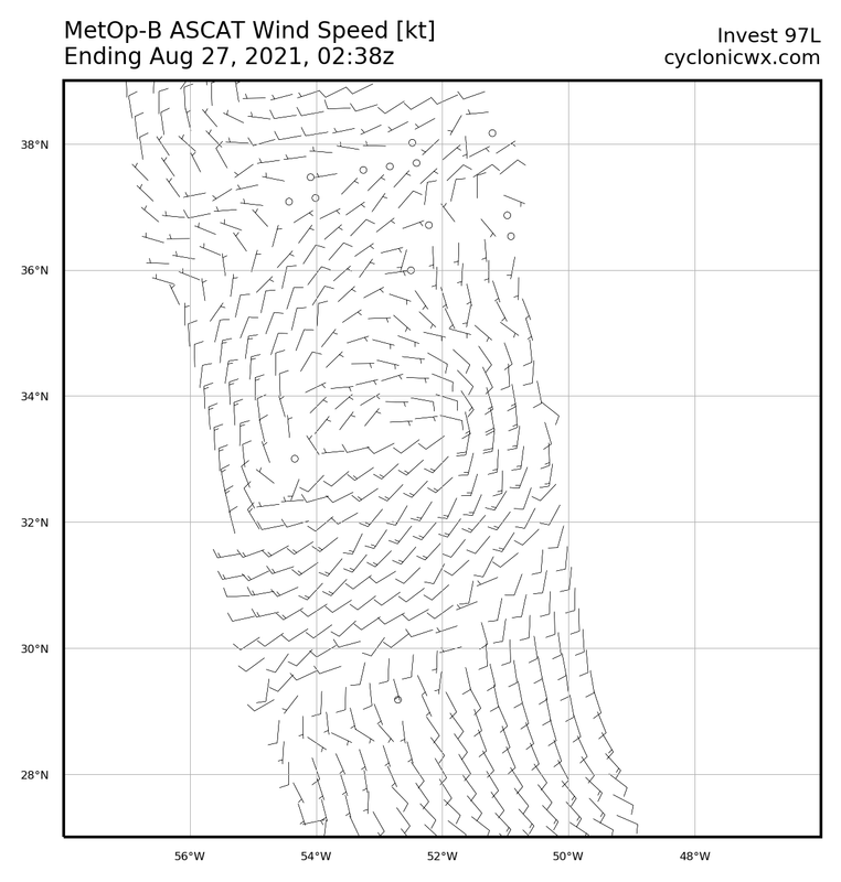
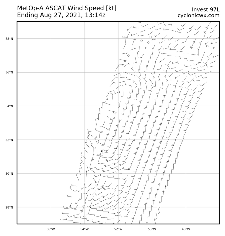
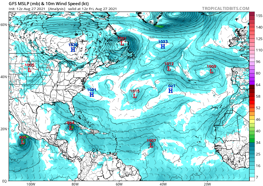
In my opinion, Invest 97L is classifiable. ASCAT shows a closed circulation. 12Z surface analysis shows a closed low. Moreover, 12Z GFS, CMC, and ICON surface analyses all show closed lows.


1 likes
-
CyclonicFury

- Category 5
- Posts: 2035
- Age: 27
- Joined: Sun Jul 02, 2017 12:32 pm
- Location: NC
- Contact:
Re: ATL: INVEST 97L - Discussion
AlphaToOmega wrote:In my opinion, Invest 97L is classifiable. ASCAT shows a closed circulation. 12Z surface analysis shows a closed low. Moreover, 12Z GFS, CMC, and ICON surface analyses all show closed lows.
https://i.postimg.cc/nhVqZP2R/ascat-97-L-barb-202108271314.png
https://i.postimg.cc/0N0gmrD2/USA-12Z.gif
https://i.postimg.cc/JnCNw42J/gfs-mslp-wind-atl-1.png
https://i.postimg.cc/8ctMrdPB/gem-mslp-wind-atl-1.png
https://i.postimg.cc/FsC0rx6h/icon-mslp-wind-atl-1.png
That looks very broad and elongated. Convection has also decreased since yesterday and is not well organized. Doesn't appear classifiable to me, at all.
4 likes
NCSU B.S. in Meteorology Class of 2021. Tropical weather blogger at http://www.cyclonicfury.com. My forecasts and thoughts are NOT official, for official forecasts please consult the National Hurricane Center.
-
Sciencerocks
- Category 5
- Posts: 10186
- Age: 40
- Joined: Thu Jul 06, 2017 1:51 am
-
Sciencerocks
- Category 5
- Posts: 10186
- Age: 40
- Joined: Thu Jul 06, 2017 1:51 am
-
Sciencerocks
- Category 5
- Posts: 10186
- Age: 40
- Joined: Thu Jul 06, 2017 1:51 am
-
AlphaToOmega
- Category 5
- Posts: 1448
- Joined: Sat Jun 26, 2021 10:51 am
- Location: Somewhere in Massachusetts
Re: ATL: INVEST 97L - Discussion
Invest 97L never ceases to confuse
Showers and thunderstorms associated with an elongated area of low
pressure located over the central Atlantic has become a little
better organized overnight. Environmental conditions are
expected to be only marginally conducive for further development.
However, a tropical depression could still form wtihin the next
couple of days. By midweek, the system is forecast to be absorbed
by a frontal system. The disturbance is expected to drift eastward
through today, then accelerate northeastward Sunday toward the
central north Atlantic.
* Formation chance through 48 hours...medium...60 percent.
* Formation chance through 5 days...medium...60 percent.
0 likes
Who is online
Users browsing this forum: No registered users and 11 guests