ATL: IDA - Models
Moderator: S2k Moderators
-
cheezyWXguy

- Category 5

- Posts: 6282
- Joined: Mon Feb 13, 2006 12:29 am
- Location: Dallas, TX
-
Keldeo1997
- Category 2

- Posts: 688
- Joined: Fri Oct 11, 2019 11:35 pm
-
grapealcoholic
- Category 2
- Posts: 703
- Joined: Tue Aug 10, 2021 3:26 pm

-
Shell Mound
- Category 5
- Posts: 2432
- Age: 33
- Joined: Thu Sep 07, 2017 3:39 pm
- Location: St. Petersburg, FL → Scandinavia
Re: ATL: INVEST 99L - Models
cheezyWXguy wrote:Man, the HWRF is like a Super-Ike
It’s no longer showing RI just before landfall, however, and for the first time suggests westerly shear could be an issue. Because 99L is now projected to be farther southwest, it is forecast to be closer to 95E’s PVS, hence the likelihood of stronger westerly shear. So 99L’s short-term intensity over the NW Caribbean will still prove critical to its future “ceiling” over the Gulf of Mexico. The past several cycles have trended toward a stronger 99L near or just south of the Yucatán Channel, which could help 99L contend with the PVS later on. Still, the large size is as concerning as the intensity.
1 likes
CVW / MiamiensisWx / Shell Mound
The posts in this forum are NOT official forecasts and should not be used as such. They are just the opinion of the poster and may or may not be backed by sound meteorological data. They are NOT endorsed by any professional institution or STORM2K. For official information, please refer to products from the NHC and NWS.

Re: ATL: INVEST 99L - Models
grapealcoholic wrote:This epic convective wrap as a 938mb storm
https://www.tropicaltidbits.com/analysis/models/hwrf/2021082600/hwrf_satIR_99L_19.png
evil looking clown sidewas
0 likes
-
Shell Mound
- Category 5
- Posts: 2432
- Age: 33
- Joined: Thu Sep 07, 2017 3:39 pm
- Location: St. Petersburg, FL → Scandinavia
Re: ATL: INVEST 99L - Models
grapealcoholic wrote:This epic convective wrap as a 938mb storm
https://www.tropicaltidbits.com/analysis/models/hwrf/2021082600/hwrf_satIR_99L_19.png
The northward turn just offshore of Galveston, TX, suggests an eventual landfall near or just east of Sabine Pass. By day five the MSLP is down to 931 mb.

2 likes
CVW / MiamiensisWx / Shell Mound
The posts in this forum are NOT official forecasts and should not be used as such. They are just the opinion of the poster and may or may not be backed by sound meteorological data. They are NOT endorsed by any professional institution or STORM2K. For official information, please refer to products from the NHC and NWS.

Re: ATL: INVEST 99L - Models
So not to completely dismiss the HWRF, but it just puts on the brakes, damn near stops, then hooks hard right then north before getting to Houston? Just looks unrealistic as a visual.
1 likes
Personal Forecast Disclaimer:
The posts in this forum are NOT official forecast and should not be used as such. They are just the opinion of the poster and may or may not be backed by sound meteorological data. They are NOT endorsed by any professional institution or storm2k.org. For official information, please refer to the NHC and NWS products.
The posts in this forum are NOT official forecast and should not be used as such. They are just the opinion of the poster and may or may not be backed by sound meteorological data. They are NOT endorsed by any professional institution or storm2k.org. For official information, please refer to the NHC and NWS products.
-
catskillfire51
- S2K Supporter

- Posts: 480
- Age: 39
- Joined: Sun Aug 26, 2012 5:40 pm
- Location: Lake Jackson, TX
Re: ATL: INVEST 99L - Models
HWRF has that north turn starting at 105 hours, looks to go to east Texas or the boarder as well.
0 likes
-
ConvergenceZone
.gif)
- Category 5
- Posts: 5241
- Joined: Fri Jul 29, 2005 1:40 am
- Location: Northern California
Re: ATL: INVEST 99L - Models
Shell Mound wrote:cheezyWXguy wrote:Man, the HWRF is like a Super-Ike
It’s no longer showing RI just before landfall, however, and for the first time suggests westerly shear could be an issue. Because 99L is now projected to be farther southwest, it is forecast to be closer to 95E’s PVS, hence the likelihood of stronger westerly shear. So 99L’s short-term intensity over the NW Caribbean will still prove critical to its future “ceiling” over the Gulf of Mexico. The past several cycles have trended toward a stronger 99L near or just south of the Yucatán Channel, which could help 99L contend with the PVS later on. Still, the large size is as concerning as the intensity.
Yet the EURO is moving EAST, the opposite direction....I don't put much faith at all in the HWRF. It's hit a few home runs in the past, but most of the time it's clueless and the outlier.....
1 likes
Re: ATL: INVEST 99L - Models
So at 102 Hours, the Euro is clipping Terrebonne Parish, much like the GFS run.
0 likes
Personal Forecast Disclaimer:
The posts in this forum are NOT official forecast and should not be used as such. They are just the opinion of the poster and may or may not be backed by sound meteorological data. They are NOT endorsed by any professional institution or storm2k.org. For official information, please refer to the NHC and NWS products.
The posts in this forum are NOT official forecast and should not be used as such. They are just the opinion of the poster and may or may not be backed by sound meteorological data. They are NOT endorsed by any professional institution or storm2k.org. For official information, please refer to the NHC and NWS products.
-
Shell Mound
- Category 5
- Posts: 2432
- Age: 33
- Joined: Thu Sep 07, 2017 3:39 pm
- Location: St. Petersburg, FL → Scandinavia
Re: ATL: INVEST 99L - Models
SoupBone wrote:So at 102 Hours, the Euro is clipping Terrebonne Parish, much like the GFS run.
The 00Z EC operational basically follows Andrew’s (1992) track through Franklin, New Iberia, and Lafayette. The run is also about 10 mb deeper vs. 12Z’s.
Last edited by Shell Mound on Thu Aug 26, 2021 1:23 am, edited 1 time in total.
2 likes
CVW / MiamiensisWx / Shell Mound
The posts in this forum are NOT official forecasts and should not be used as such. They are just the opinion of the poster and may or may not be backed by sound meteorological data. They are NOT endorsed by any professional institution or STORM2K. For official information, please refer to products from the NHC and NWS.
Re: ATL: INVEST 99L - Models
The Euro almost mirrors the GFS.

3 likes
Personal Forecast Disclaimer:
The posts in this forum are NOT official forecast and should not be used as such. They are just the opinion of the poster and may or may not be backed by sound meteorological data. They are NOT endorsed by any professional institution or storm2k.org. For official information, please refer to the NHC and NWS products.
The posts in this forum are NOT official forecast and should not be used as such. They are just the opinion of the poster and may or may not be backed by sound meteorological data. They are NOT endorsed by any professional institution or storm2k.org. For official information, please refer to the NHC and NWS products.
-
CrazyC83
- Professional-Met

- Posts: 34315
- Joined: Tue Mar 07, 2006 11:57 pm
- Location: Deep South, for the first time!
Re: ATL: INVEST 99L - Models
Shell Mound wrote:SoupBone wrote:So at 102 Hours, the Euro is clipping Terrebonne Parish, much like the GFS run.
The 00Z EC operational basically follows Andrew’s (1992) track through Franklin, New Iberia, and Lafayette. The run is also about 10 mb deeper vs. 12Z’s.
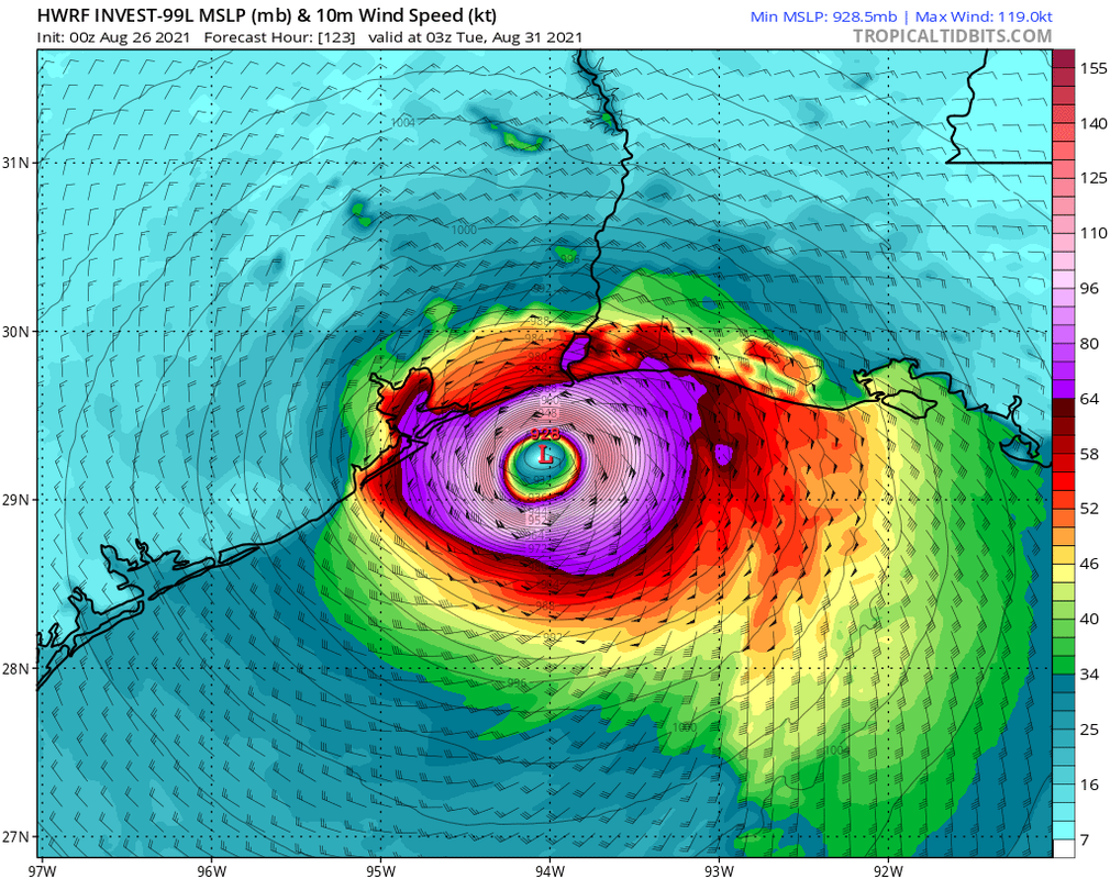
Slightly west of the Gustav track. HWRF brings it into Port Arthur at 931 mb (category 4).
0 likes
-
Shell Mound
- Category 5
- Posts: 2432
- Age: 33
- Joined: Thu Sep 07, 2017 3:39 pm
- Location: St. Petersburg, FL → Scandinavia
Re: ATL: INVEST 99L - Models
SoupBone wrote:The Euro almost mirrors the GFS.

Compared to yesterday’s 12Z, today’s 00Z EC operational is much farther east and also slightly deeper (958 vs. 964 mb) at landfall.
0 likes
CVW / MiamiensisWx / Shell Mound
The posts in this forum are NOT official forecasts and should not be used as such. They are just the opinion of the poster and may or may not be backed by sound meteorological data. They are NOT endorsed by any professional institution or STORM2K. For official information, please refer to products from the NHC and NWS.


-
grapealcoholic
- Category 2
- Posts: 703
- Joined: Tue Aug 10, 2021 3:26 pm

-
Nederlander
- S2K Supporter
- Posts: 1259
- Joined: Sat Jul 19, 2008 4:28 pm
- Location: Conroe, TX
Re: ATL: INVEST 99L - Models
No thanks… that would cripple a lot of the petrochemical industry. Hopefully it’s just another phantom monster the HWRF likes to spit out
0 likes
-
supercane4867
- Category 5
- Posts: 4966
- Joined: Wed Nov 14, 2012 10:43 am
Re: ATL: INVEST 99L - Models
The one thing HWRF initialed correctly is 32C SSTs

Also the slow down at the end is very reasonable given the predicted pattern

Also the slow down at the end is very reasonable given the predicted pattern
1 likes

Re: ATL: INVEST 99L - Models
EC hits the SC LA coast also with a western component at landfall. That's pretty much all the globals. Ridge protecting FL remains strong. We've all got a couple intense days ahead. Seems like someone's getting hit by at least a Cat 2.
1 likes

Re: ATL: INVEST 99L - Models
06z GFS landfalls quite far on Cuba, is this even a semi-realistic possibility or can we throw this one away?

0 likes
Who is online
Users browsing this forum: No registered users and 190 guests