2021 Global Model Runs Discussion (Out thru day 16)

This is the general tropical discussion area. Anyone can take their shot at predicting a storms path.

Moderator: S2k Moderators

Forum rules

The posts in this forum are NOT official forecasts and should not be used as such. They are just the opinion of the poster and may or may not be backed by sound meteorological data. They are NOT endorsed by any professional institution or STORM2K. For official information, please refer to products from the National Hurricane Center and National Weather Service.

Help Support Storm2K
Message
Author
User avatar
SFLcane
S2K Supporter
S2K Supporter
Posts: 10163
Age: 47
Joined: Sat Jun 05, 2010 1:44 pm
Location: Lake Worth Florida

Re: 2021 Global Model Runs Discussion (Out thru day 16)

#1081 Postby SFLcane » Thu Aug 26, 2021 4:15 am

SouthFLTropics wrote:Don’t speak too soon. Late in this GFS run it looks like the ridge may build back in. Of course this is out in lala land but I don’t think an OTS track is guaranteed with anything just yet.

Sent from my iPhone using Tapatalk


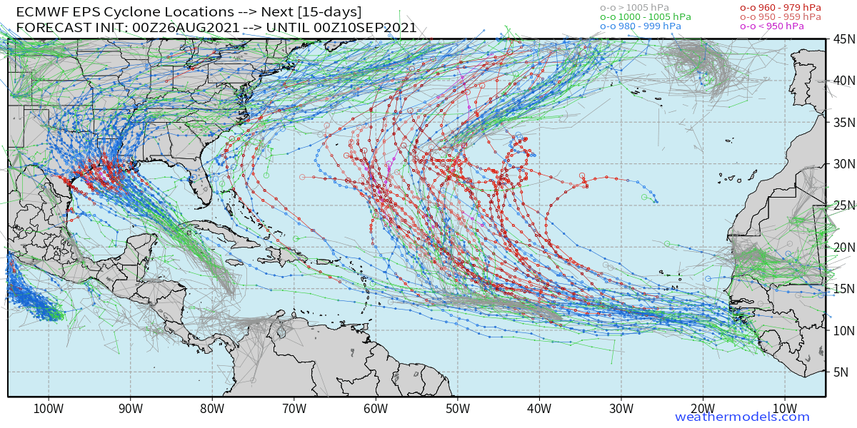
Recurve near 50-60w is still the most likely outcome on the European ensembles.

Image
3 likes   

jlauderdal
S2K Supporter
S2K Supporter
Posts: 7182
Joined: Wed May 19, 2004 5:46 am
Location: NE Fort Lauderdale
Contact:

Re: RE: Re: 2021 Global Model Runs Discussion (Out thru day 16)

#1082 Postby jlauderdal » Thu Aug 26, 2021 4:59 am

chaser1 wrote:
jlauderdal wrote:
emeraldislenc wrote:To be honest this is one reason I do not use storm 2 k like I use too. So many people say OTS or dry air or talk about the " shredder" with every storm. The site is not just as interesting to me like it used to be. Maybe I am being to honest.
Its a discussion board...we discuss various scenarios...always refer to the nhc for the best track forecast


However......... because this IS a discussion board, one need always "consider the source" as well. Any bobble-head can blurt out an opinion. If you take the time, you'll come to recognize some posters here to be less flippant and a bit more grounded in their analysis.

1. Consider a posters location: is the location dictating the opinion-"-removed-"
2. Number of posts: experience matters in the tropics, its not all about eye candy model runs like the hwrf but those runs can be right, the gulf is very favorable now so the hwrf intensity isn't crazy on 99L. However, a big post count can be from just posting maps, discos, etc so be careful
3. Longevity: length matters, the more rodeos one has seen the more likely they are to know what is really happening and going to happen but its the tropics so rarely is their a sure bet especially with the intensity
4. Post Style: Just because a post has technical terms and the poster seems to be "smarter" than others doesn't mean they are being used correctly in the post or the context is correct, seen many of those posters come and go over the last 17 years on this board.
5. Catch up on the last few hours of posts before starting to reply, you may have missed something important and your question was already answered.

If you don't like the tone of the board or its not interesting, you are free to not view the board. If you really enjoy the board, MAKE A DONATION. Think about the amount of time, entertainment, the knowledge you are getting.
8 likes   

Shell Mound
Category 5
Category 5
Posts: 2434
Age: 32
Joined: Thu Sep 07, 2017 3:39 pm
Location: St. Petersburg, FL → Scandinavia

Re: 2021 Global Model Runs Discussion (Out thru day 16)

#1083 Postby Shell Mound » Thu Aug 26, 2021 5:57 am

SFLcane wrote:
SouthFLTropics wrote:Don’t speak too soon. Late in this GFS run it looks like the ridge may build back in. Of course this is out in lala land but I don’t think an OTS track is guaranteed with anything just yet.

Sent from my iPhone using Tapatalk


Recurve near 50-60w is still the most likely outcome on the European ensembles.

https://i.postimg.cc/PqJ5vtdV/EDC3-F839-09-B6-43-D1-9031-610-ECDF8-A903.png

However, most members have trended weaker and farther southwest by day seven. A weaker, faster system would be likely to track farther W before turning.
0 likes   
CVW / MiamiensisWx / Shell Mound
The posts in this forum are NOT official forecasts and should not be used as such. They are just the opinion of the poster and may or may not be backed by sound meteorological data. They are NOT endorsed by any professional institution or STORM2K. For official information, please refer to products from the NHC and NWS.

User avatar
chris_fit
Category 5
Category 5
Posts: 3222
Age: 42
Joined: Wed Sep 10, 2003 11:58 pm
Location: Tampa Bay Area, FL

Re: 2021 Global Model Runs Discussion (Out thru day 16)

#1084 Postby chris_fit » Thu Aug 26, 2021 6:00 am

SFLcane wrote:
SouthFLTropics wrote:Don’t speak too soon. Late in this GFS run it looks like the ridge may build back in. Of course this is out in lala land but I don’t think an OTS track is guaranteed with anything just yet.

Sent from my iPhone using Tapatalk


Recurve near 50-60w is still the most likely outcome on the European ensembles.

https://i.postimg.cc/PqJ5vtdV/EDC3-F839-09-B6-43-D1-9031-610-ECDF8-A903.png


00Z Euro Oper Agrees ---> :flag: :fishing:

Image
0 likes   

User avatar
aspen
Category 5
Category 5
Posts: 8818
Joined: Sat Oct 12, 2019 7:10 pm
Location: Connecticut, USA

Re: 2021 Global Model Runs Discussion (Out thru day 16)

#1085 Postby aspen » Thu Aug 26, 2021 6:17 am

Quite a strong signal for a MDR major from the Euro. The current track of a recurve around 50-55W along with quick development should give the basin a massive boost in ACE. If neither 97L nor 98L develop, this will be Julian.
0 likes   
Irene '11 Sandy '12 Hermine '16 5/15/2018 Derecho Fay '20 Isaias '20 Elsa '21 Henri '21 Ida '21

I am only a meteorology enthusiast who knows a decent amount about tropical cyclones. Look to the professional mets, the NHC, or your local weather office for the best information.

User avatar
Blown Away
S2K Supporter
S2K Supporter
Posts: 10145
Joined: Wed May 26, 2004 6:17 am

Re: 2021 Global Model Runs Discussion (Out thru day 16)

#1086 Postby Blown Away » Thu Aug 26, 2021 6:46 am

chris_fit wrote:
SFLcane wrote:
SouthFLTropics wrote:Don’t speak too soon. Late in this GFS run it looks like the ridge may build back in. Of course this is out in lala land but I don’t think an OTS track is guaranteed with anything just yet.

Sent from my iPhone using Tapatalk


Recurve near 50-60w is still the most likely outcome on the European ensembles.

https://i.postimg.cc/PqJ5vtdV/EDC3-F839-09-B6-43-D1-9031-610-ECDF8-A903.png


00Z Euro Oper Agrees ---> :flag: :fishing:

https://i.imgur.com/dbyDrBu.gif


Image

00z EURO continues to show a strong low moving off Africa in a few days and becoming a strong system in the Central Atlantic. No way you can make a final "fish" call 7+ days out. Euro/GFS have been flopping by hundreds of miles in that 7-10 day window,
2 likes   
Hurricane Eye Experience: David 79, Irene 99, Frances 04, Jeanne 04, Wilma 05... EYE COMING MY WAY IN 2024…
Hurricane Brush Experience: Andrew 92, Erin 95, Floyd 99, Matthew 16, Irma 17, Ian 22, Nicole 22…

User avatar
Spacecoast
Category 2
Category 2
Posts: 758
Joined: Thu Aug 31, 2017 2:03 pm

Re: 2021 Global Model Runs Discussion (Out thru day 16)

#1087 Postby Spacecoast » Thu Aug 26, 2021 10:38 am

0z ECMF thick line is Operational, thin line is ens mean...

Image
0 likes   

User avatar
Kohlecane
Category 2
Category 2
Posts: 593
Age: 33
Joined: Sun Jul 31, 2011 11:03 pm
Location: Beaufort, SC

Re: 2021 Global Model Runs Discussion (Out thru day 16)

#1088 Postby Kohlecane » Thu Aug 26, 2021 11:30 am

12z GFS has future Ida's sibling coming through the same doorway :double:
0 likes   
Once I see the REDS and GREENS Converge on a Base Velocity. ... I'm There!!

This is NOT an Official Forecast....Just my Opinion. For official information, please refer to the NHC and NWS products.
HIGHLIGHTS : '13 El Reno Tornado : 2013 Storm Chaser Tour, Joaquin; SC flood event, Matthew '16, Lowcountry Snow storm Jan '18

IcyTundra
Category 5
Category 5
Posts: 1205
Joined: Mon Jun 07, 2021 9:32 pm
Location: Dickinson, Texas

Re: 2021 Global Model Runs Discussion (Out thru day 16)

#1089 Postby IcyTundra » Thu Aug 26, 2021 11:45 am

GFS has been insisting on another storm developing in the Carribean late next week... Ida 2.0? It has been consistent in showing development in that area late next week for over a week now kind of similar to how the GFS was consistently showing soon to be Ida forming for well over a week. The GFS' consistency with this potential development makes me think it could be on to something.

Image

Has a TD forming 6-7 days from now which is close enough out that the GFS may be on to something.
0 likes   

IcyTundra
Category 5
Category 5
Posts: 1205
Joined: Mon Jun 07, 2021 9:32 pm
Location: Dickinson, Texas

Re: 2021 Global Model Runs Discussion (Out thru day 16)

#1090 Postby IcyTundra » Thu Aug 26, 2021 11:47 am

Kohlecane wrote:12z GFS has future Ida's sibling coming through the same doorway :double:


GFS has been consistent in developing it for over a week now very consistent... Has a TD forming 6-7 days from now in the Carribean so it's not like this is fantasy land. With it only being about a week out from potential development and the GFS' consistency with developing it for over a week now I think the GFS may be on to something. I think the CMC also shows development in this area.
0 likes   

User avatar
Teban54
Category 5
Category 5
Posts: 3204
Joined: Sat May 19, 2018 1:19 pm

Re: 2021 Global Model Runs Discussion (Out thru day 16)

#1091 Postby Teban54 » Thu Aug 26, 2021 11:52 am

IcyTundra wrote:GFS has been insisting on another storm developing in the Carribean late next week... Ida 2.0? It has been consistent in showing development in that area late next week for over a week now kind of similar to how the GFS was consistently showing soon to be Ida forming for well over a week. The GFS' consistency with this potential development makes me think it could be on to something.

https://i.ibb.co/FX5SMR6/gfs-mslp-pcpn-watl-fh138-180.gif

Has a TD forming 6-7 days from now which is close enough out that the GFS may be on to something.

Hopefully the waters in the Caribbean and Gulf won't be nearly as warm as the ones TD9/Ida will tap into (should this storm develop), but that might be wishful thinking.
0 likes   

IcyTundra
Category 5
Category 5
Posts: 1205
Joined: Mon Jun 07, 2021 9:32 pm
Location: Dickinson, Texas

Re: 2021 Global Model Runs Discussion (Out thru day 16)

#1092 Postby IcyTundra » Thu Aug 26, 2021 11:54 am

Teban54 wrote:
IcyTundra wrote:GFS has been insisting on another storm developing in the Carribean late next week... Ida 2.0? It has been consistent in showing development in that area late next week for over a week now kind of similar to how the GFS was consistently showing soon to be Ida forming for well over a week. The GFS' consistency with this potential development makes me think it could be on to something.

https://i.ibb.co/FX5SMR6/gfs-mslp-pcpn-watl-fh138-180.gif

Has a TD forming 6-7 days from now which is close enough out that the GFS may be on to something.

Hopefully the waters in the Caribbean and Gulf won't be nearly as warm as the ones TD9/Ida will tap into (should this storm develop), but that might be wishful thinking.


Would really depend on the track this potential storm would take. If it takes a track further west than Ida then it would mostly miss the cooler waters left by Ida.
0 likes   

IcyTundra
Category 5
Category 5
Posts: 1205
Joined: Mon Jun 07, 2021 9:32 pm
Location: Dickinson, Texas

Re: 2021 Global Model Runs Discussion (Out thru day 16)

#1093 Postby IcyTundra » Thu Aug 26, 2021 11:56 am

Image

12Z CMC like the 12Z GFS shows a TD forming next Wednesday evening.
0 likes   

User avatar
Kohlecane
Category 2
Category 2
Posts: 593
Age: 33
Joined: Sun Jul 31, 2011 11:03 pm
Location: Beaufort, SC

Re: 2021 Global Model Runs Discussion (Out thru day 16)

#1094 Postby Kohlecane » Thu Aug 26, 2021 12:06 pm

Okay so GFS is just rude want's to take it to TX/LA border as a Cat 4, at this point and after and still currently dealing with soon to be IDA, if this plays out we shouldn't focus on a location but rather another potential CONUS impact
1 likes   
Once I see the REDS and GREENS Converge on a Base Velocity. ... I'm There!!

This is NOT an Official Forecast....Just my Opinion. For official information, please refer to the NHC and NWS products.
HIGHLIGHTS : '13 El Reno Tornado : 2013 Storm Chaser Tour, Joaquin; SC flood event, Matthew '16, Lowcountry Snow storm Jan '18

IcyTundra
Category 5
Category 5
Posts: 1205
Joined: Mon Jun 07, 2021 9:32 pm
Location: Dickinson, Texas

Re: 2021 Global Model Runs Discussion (Out thru day 16)

#1095 Postby IcyTundra » Thu Aug 26, 2021 12:12 pm

Kohlecane wrote:Okay so GFS is just rude want's to take it to TX/LA border as a Cat 4, at this point and after and still currently dealing with soon to be IDA, if this plays out we shouldn't focus on a location but rather another potential CONUS impact


Yeah we have 0 clue where this would potentially go but the GFS has consistently been showing something forming next week and getting into the gulf by Labor Day weekend.
0 likes   

User avatar
SoupBone
Category 5
Category 5
Posts: 3111
Joined: Tue Sep 20, 2005 5:24 pm

Re: 2021 Global Model Runs Discussion (Out thru day 16)

#1096 Postby SoupBone » Thu Aug 26, 2021 12:19 pm

GFS is known to spin up phantoms though, so even though I am obviously paying attention like the rest of you, when other models start seeing it, I'll start getting more concerned. I do think the CMC showed it too heading toward the panhandle. So it's not completely out there.
0 likes   
Personal Forecast Disclaimer:
The posts in this forum are NOT official forecast and should not be used as such. They are just the opinion of the poster and may or may not be backed by sound meteorological data. They are NOT endorsed by any professional institution or storm2k.org. For official information, please refer to the NHC and NWS products.

User avatar
InfernoFlameCat
Category 5
Category 5
Posts: 2102
Age: 22
Joined: Mon Dec 14, 2020 10:52 am
Location: Buford, GA

Re: 2021 Global Model Runs Discussion (Out thru day 16)

#1097 Postby InfernoFlameCat » Thu Aug 26, 2021 12:19 pm

Two majors in the span of a week. Very rare. Reminds me if it does occur of ETA and IOTA. lets hope this does not come to fruition. Louisiana may have angered Mother Nature significantly.
0 likes   
I am by no means a professional. DO NOT look at my forecasts for official information or make decisions based on what I post.

Goal: to become a registered expert over tropical and subtropical cyclones.

User avatar
SoupBone
Category 5
Category 5
Posts: 3111
Joined: Tue Sep 20, 2005 5:24 pm

Re: 2021 Global Model Runs Discussion (Out thru day 16)

#1098 Postby SoupBone » Thu Aug 26, 2021 12:21 pm

InfernoFlameCat wrote:Two majors in the span of a week. Very rare. Reminds me if it does occur of ETA and IOTA. lets hope this does not come to fruition. Louisiana may have angered Mother Nature significantly.


In my family, we laugh and say it's the LSU championship. It was just too perfect of a season, so someone made a deal. :lol:
1 likes   
Personal Forecast Disclaimer:
The posts in this forum are NOT official forecast and should not be used as such. They are just the opinion of the poster and may or may not be backed by sound meteorological data. They are NOT endorsed by any professional institution or storm2k.org. For official information, please refer to the NHC and NWS products.

User avatar
aspen
Category 5
Category 5
Posts: 8818
Joined: Sat Oct 12, 2019 7:10 pm
Location: Connecticut, USA

Re: 2021 Global Model Runs Discussion (Out thru day 16)

#1099 Postby aspen » Thu Aug 26, 2021 12:38 pm

GFS recurves the 8/31 wave earlier than pretty much every model run before it, but that is due to 98L wandering around the Azores for a while and continuing to weaken the ridge, instead of quickly being ejected into colder waters and dying.
0 likes   
Irene '11 Sandy '12 Hermine '16 5/15/2018 Derecho Fay '20 Isaias '20 Elsa '21 Henri '21 Ida '21

I am only a meteorology enthusiast who knows a decent amount about tropical cyclones. Look to the professional mets, the NHC, or your local weather office for the best information.

User avatar
SoupBone
Category 5
Category 5
Posts: 3111
Joined: Tue Sep 20, 2005 5:24 pm

Re: 2021 Global Model Runs Discussion (Out thru day 16)

#1100 Postby SoupBone » Thu Aug 26, 2021 12:47 pm

aspen wrote:GFS recurves the 8/31 wave earlier than pretty much every model run before it, but that is due to 98L wandering around the Azores for a while and continuing to weaken the ridge, instead of quickly being ejected into colder waters and dying.


CMC takes it to the panhandle of Florida again.
0 likes   
Personal Forecast Disclaimer:
The posts in this forum are NOT official forecast and should not be used as such. They are just the opinion of the poster and may or may not be backed by sound meteorological data. They are NOT endorsed by any professional institution or storm2k.org. For official information, please refer to the NHC and NWS products.


Return to “Talkin' Tropics”

Who is online

Users browsing this forum: No registered users and 30 guests