2021 Indicators: SST's / SAL / MSLP / Shear / Steering / Instability / Sat Images
Moderator: S2k Moderators
Forum rules

The posts in this forum are NOT official forecasts and should not be used as such. They are just the opinion of the poster and may or may not be backed by sound meteorological data. They are NOT endorsed by any professional institution or STORM2K. For official information, please refer to products from the National Hurricane Center and National Weather Service.
-
AutoPenalti
- Category 5

- Posts: 4091
- Age: 29
- Joined: Mon Aug 17, 2015 4:16 pm
- Location: Ft. Lauderdale, Florida
Re: 2021 Indicators: SST's / SAL / MSLP / Shear / Steering / Instability / Sat Images
Ridge seems to build back in tandem with the Euro wave coming off Africa on the 30th.
0 likes
The posts in this forum are NOT official forecasts and should not be used as such. They are just the opinion of the poster and may or may not be backed by sound meteorological data. They are NOT endorsed by any professional institution or STORM2K. For official information, please refer to products from the NHC and NWS.
Model Runs Cheat Sheet:
GFS (5:30 AM/PM, 11:30 AM/PM)
HWRF, GFDL, UKMET, NAVGEM (6:30-8:00 AM/PM, 12:30-2:00 AM/PM)
ECMWF (1:45 AM/PM)
TCVN is a weighted averaged
-
SFLcane

- S2K Supporter

- Posts: 10281
- Age: 48
- Joined: Sat Jun 05, 2010 1:44 pm
- Location: Lake Worth Florida
Re: 2021 Indicators: SST's / SAL / MSLP / Shear / Steering / Instability / Sat Images
NDG wrote:SFLcane wrote:NDG wrote:The pattern since the NAO went negative around Aug 10th, the PNA went negative which pumped up ridging across the western Atlantic Basin and SE Canada.
I don't see a +PNA returning any time soon.
https://i.imgur.com/DuBjX7x.gif
What’s your take on the over 500mb steering long range?
The pattern is already set, what we’ve been seeing is what we will continue to see through at least October.
NDG, Everything on the euro guidance screams quick recurve. Numerous trofs waiting to pick it up and a thin ridge. Correct me if I am wrong
2 likes

Re: 2021 Indicators: SST's / SAL / MSLP / Shear / Steering / Instability / Sat Images
SFLcane wrote:NDG wrote:SFLcane wrote:
What’s your take on the over 500mb steering long range?
The pattern is already set, what we’ve been seeing is what we will continue to see through at least October.
NDG, Everything on the euro guidance screams quick recurve. Numerous trofs waiting to pick it up and a thin ridge. Correct me if I am wrong
Anything that doesn't develop that far east will have a chance to make it to the western basin, they have all been in fairly low latitude which has been the pattern so far this season.
Look at 99L, it mostly came out of the ITCZ, I wouldn't be paying too much attention at anything that tries to develop out that far in the eastern basin, it has been hostile any way but I am sure we will see a few develop and go out to sea like a majority of them do later in September.
5 likes


Re: 2021 Indicators: SST's / SAL / MSLP / Shear / Steering / Instability / Sat Images
Here comes the big bad wolf 
Rough couple of weeks ahead
https://twitter.com/MJVentrice/status/1430903123120295944
Rough couple of weeks ahead
https://twitter.com/MJVentrice/status/1430903123120295944
4 likes

Re: 2021 Indicators: SST's / SAL / MSLP / Shear / Steering / Instability / Sat Images
In case anyone was wondering about the MJO, you probably guessed right.
https://www.cpc.ncep.noaa.gov/products/ ... r_wh.shtml
And here's the Kelvin Wave moving in:
http://mikeventrice.weebly.com/cckwmjo.html
https://www.cpc.ncep.noaa.gov/products/ ... r_wh.shtml
And here's the Kelvin Wave moving in:
http://mikeventrice.weebly.com/cckwmjo.html
1 likes
-
Blown Away

- S2K Supporter
- Posts: 10253
- Joined: Wed May 26, 2004 6:17 am
Re: 2021 Indicators: SST's / SAL / MSLP / Shear / Steering / Instability / Sat Images
Strange pattern with troughing everywhere. Systems making sharp right turns from low latitudes in Central Atlantic and unfortunately for NW Caribbean & NGOM systems in that area like Ida will go Northerly.
0 likes
Hurricane Eye Experience: David 79, Irene 99, Frances 04, Jeanne 04, Wilma 05… Hurricane Brush Experience: Andrew 92, Erin 95, Floyd 99, Matthew 16, Irma 17, Ian 22, Nicole 22…
-
SFLcane
- S2K Supporter
- Posts: 10281
- Age: 48
- Joined: Sat Jun 05, 2010 1:44 pm
- Location: Lake Worth Florida
Re: 2021 Indicators: SST's / SAL / MSLP / Shear / Steering / Instability / Sat Images
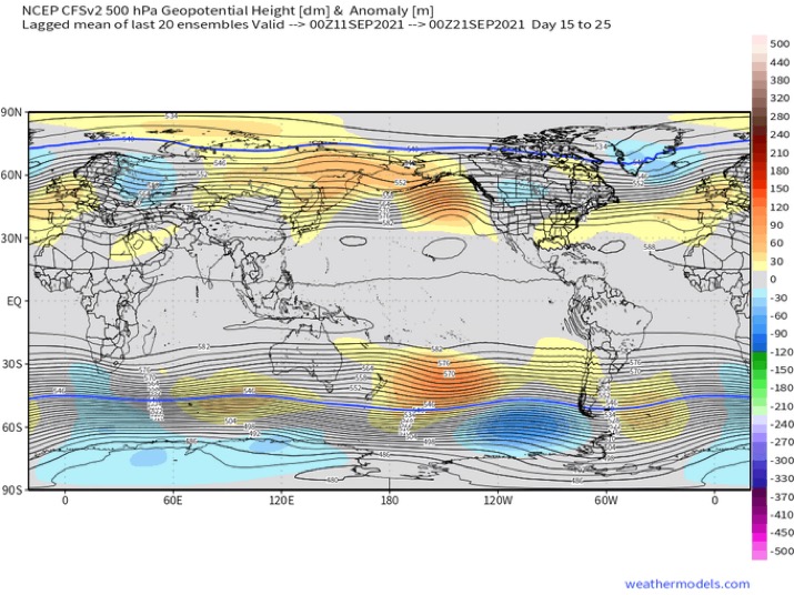
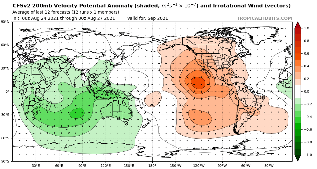
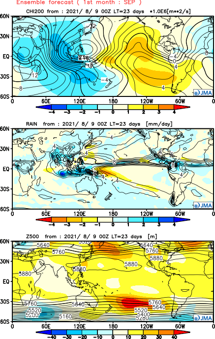
Pattern change potentially coming showing up on the cfs ensembles with more ridging established.
5 likes
-
SFLcane
- S2K Supporter
- Posts: 10281
- Age: 48
- Joined: Sat Jun 05, 2010 1:44 pm
- Location: Lake Worth Florida
Re: 2021 Indicators: SST's / SAL / MSLP / Shear / Steering / Instability / Sat Images
I am beginning to think this year is like 2020 Where we get one big CV storm (teddy) that curves. CV seasons have been lame recently Other then 2017. I am very concerned for Florida this late September especially into October. I think with La Niña around it’s going to be an all out assault coming from there. Also I would be surprised if Caribbean stuff tracks like in 2020 (towards Louisiana) as the Ridge isn't as strong this year. We are just getting started and it would not surprise me one bit to see 50+ ace just in the month of October alone.
0 likes
-
AlphaToOmega
- Category 5
- Posts: 1448
- Joined: Sat Jun 26, 2021 10:51 am
- Location: Somewhere in Massachusetts
Re: 2021 Indicators: SST's / SAL / MSLP / Shear / Steering / Instability / Sat Images
Hurricane Ida is on track to become a major hurricane. Invests 97L and 98L both seem promising for development. Should this happen, it would end off August 2021 with 11 storms, 4 hurricanes, and 2 major hurricanes. Because this hurricane season is expected to be back-loaded with an impending La Nina and because September seems quite favorable for development, it would not take much to exhaust the current naming list. This season may be a very historic hurricane season, rivalling 1933, 2005, and 2020.
0 likes
-
AlphaToOmega
- Category 5
- Posts: 1448
- Joined: Sat Jun 26, 2021 10:51 am
- Location: Somewhere in Massachusetts
Re: 2021 Indicators: SST's / SAL / MSLP / Shear / Steering / Instability / Sat Images
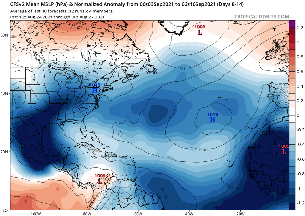
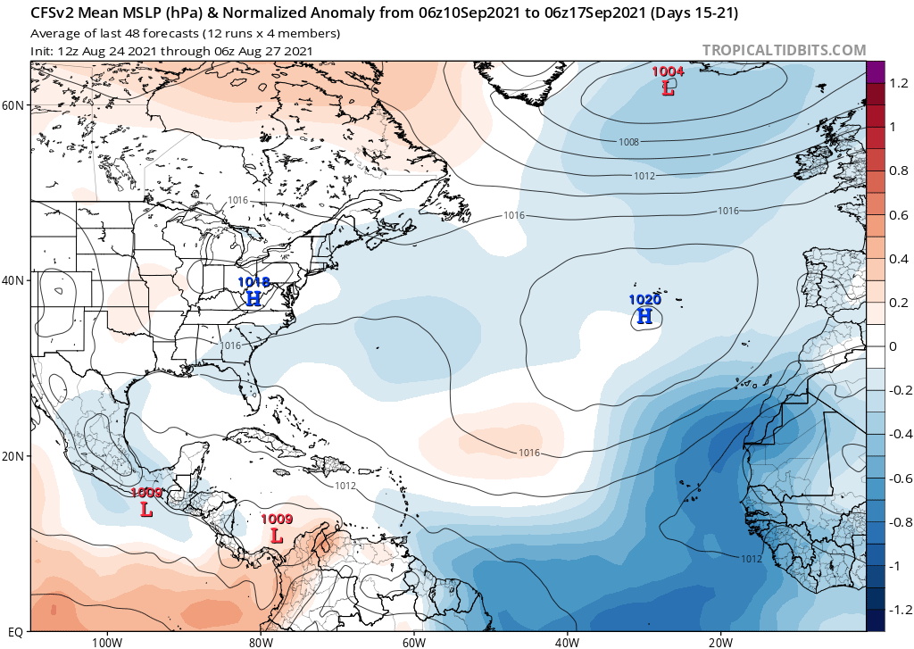
Below-average MSLPs throughout the entire Atlantic forecasted for early and mid September
0 likes
-
AlphaToOmega
- Category 5
- Posts: 1448
- Joined: Sat Jun 26, 2021 10:51 am
- Location: Somewhere in Massachusetts
Re: 2021 Indicators: SST's / SAL / MSLP / Shear / Steering / Instability / Sat Images
September is going to be a critical month for this hurricane season. If September is really active (8 or more storms), it would mean 2021 is on track with seasons such as 2020 and 2005. If September is not really active, it would mean 2021 is on track with seasons such as 1995 and 2011. As of now, September seems to be really favorable for tropical development, and it would not surprise me if 2021 ends up rivaling 2020 and 2005. Rising air over Africa and the Indian Ocean would support very strong tropical waves, and sinking air over the Pacific Ocean and the Americas would support a suppressed East Pacific season.
3 likes


Re: 2021 Indicators: SST's / SAL / MSLP / Shear / Steering / Instability / Sat Images
IcyTundra wrote:https://twitter.com/webberweather/status/1431679649004679168
One of the EPS models show another strong system taking a similar track to Ida.
0 likes
-
toad strangler

- S2K Supporter
- Posts: 4546
- Joined: Sun Jul 28, 2013 3:09 pm
- Location: Earth
- Contact:
-
tolakram
- Admin

- Posts: 20186
- Age: 62
- Joined: Sun Aug 27, 2006 8:23 pm
- Location: Florence, KY (name is Mark)
Re: 2021 Indicators: SST's / SAL / MSLP / Shear / Steering / Instability / Sat Images
Yes, we beat 2013 
15 likes
M a r k
- - - - -
Join us in chat: Storm2K Chatroom Invite. Android and IOS apps also available.
The posts in this forum are NOT official forecasts and should not be used as such. Posts are NOT endorsed by any professional institution or STORM2K.org. For official information and forecasts, please refer to NHC and NWS products.
-
weeniepatrol

- Category 5
- Posts: 1343
- Joined: Sat Aug 22, 2020 5:30 pm
- Location: WA State
Re: 2021 Indicators: SST's / SAL / MSLP / Shear / Steering / Instability / Sat Images
tolakram wrote:Yes, we beat 2013
Hallelujah!

0 likes
-
weeniepatrol
- Category 5
- Posts: 1343
- Joined: Sat Aug 22, 2020 5:30 pm
- Location: WA State
Re: 2021 Indicators: SST's / SAL / MSLP / Shear / Steering / Instability / Sat Images
Death, taxes, and the climatological peak of the Atlantic hurricane season

6 likes

Re: 2021 Indicators: SST's / SAL / MSLP / Shear / Steering / Instability / Sat Images
Already at 9/4/2, and it’s only August 29th. No other season in this current active streak has had two majors before September; the last was 2010. August will probably finish off at 11/4/2 with the two depressions becoming Julian and Kate, but it’s possible TD10 becomes a hurricane in the subtropics if it survives the next few days. We’ll see a massive ACE boost from future Larry, which could be a long-tracking MDR major and stay away from land. By September 5th, we might be at 12/6/3.
Yeah the season for season cancel posts is pretty much done now.
Yeah the season for season cancel posts is pretty much done now.
7 likes
Irene '11 Sandy '12 Hermine '16 5/15/2018 Derecho Fay '20 Isaias '20 Elsa '21 Henri '21 Ida '21
I am only a meteorology enthusiast who knows a decent amount about tropical cyclones. Look to the professional mets, the NHC, or your local weather office for the best information.
I am only a meteorology enthusiast who knows a decent amount about tropical cyclones. Look to the professional mets, the NHC, or your local weather office for the best information.
-
toad strangler
- S2K Supporter
- Posts: 4546
- Joined: Sun Jul 28, 2013 3:09 pm
- Location: Earth
- Contact:
Re: 2021 Indicators: SST's / SAL / MSLP / Shear / Steering / Instability / Sat Images
aspen wrote:Already at 9/4/2, and it’s only August 29th. No other season in this current active streak has had two majors before September; the last was 2010. August will probably finish off at 11/4/2 with the two depressions becoming Julian and Kate, but it’s possible TD10 becomes a hurricane in the subtropics if it survives the next few days. We’ll see a massive ACE boost from future Larry, which could be a long-tracking MDR major and stay away from land. By September 5th, we might be at 12/6/3.
Yeah the season for season cancel posts is pretty much done now.
That was done two weeks ago
0 likes
My Weather Station
https://www.wunderground.com/dashboard/pws/KFLPORTS603
https://www.wunderground.com/dashboard/pws/KFLPORTS603
Who is online
Users browsing this forum: Ulf and 222 guests