ATL: IDA - Remnants - Discussion

Moderator: S2k Moderators

Message
Author
otowntiger
Category 5
Category 5
Posts: 1921
Joined: Tue Aug 31, 2004 7:06 pm

Re: ATL: NINE - Tropical Depression - Discussion Update= Recon is flying

#541 Postby otowntiger » Thu Aug 26, 2021 1:00 pm

IcyTundra wrote:Thinking this could take a Gustav like track (probably slighty further east) but be slightly stronger.

the latest NHC track and intensity is exactly the same as Gustav in '08. Came in at that angle around Grand Isle and if I recall correctly the intensity at landfall was 110 mph.
0 likes   

User avatar
Steve
S2K Supporter
S2K Supporter
Posts: 9621
Joined: Sat Apr 05, 2003 11:41 pm
Location: Not a state-caster

Re: ATL: NINE - Tropical Depression - Discussion

#542 Postby Steve » Thu Aug 26, 2021 1:02 pm

wxman57 wrote:Not much time to post. I have Cat 3 landfall south of Morgan City around 6pm Sunday. I'm east of TVCN (consensus) and a little faster, thinking consensus is shifting east of Vermilion Bay. Need to get this one inland before the big Labor Day Hurricane hits Louisiana the Tuesday after Labor Day (GFS).


Yay 2021.
5 likes   

User avatar
Tireman4
S2K Supporter
S2K Supporter
Posts: 5853
Age: 59
Joined: Fri Jun 30, 2006 1:08 pm
Location: Humble, Texas
Contact:

Re: ATL: NINE - Tropical Depression - Discussion

#543 Postby Tireman4 » Thu Aug 26, 2021 1:02 pm

SoupBone wrote:
wxman57 wrote:Not much time to post. I have Cat 3 landfall south of Morgan City around 6pm Sunday. I'm east of TVCN (consensus) and a little faster, thinking consensus is shifting east of Vermilion Bay. Need to get this one inland before the big Labor Day Hurricane hits Louisiana the Tuesday after Labor Day (GFS).


I know this is your jokey side, but you just had people pee their pants a little. :lol:


He is full of levity during this busy time, that Wxman 57 is... ( he secretly likes the cold..shh..dont tell anyone..LOL)
3 likes   

Javlin
Category 5
Category 5
Posts: 1620
Age: 64
Joined: Fri Jul 09, 2004 7:58 pm
Location: ms gulf coast

Re: ATL: NINE - Tropical Depression - Discussion

#544 Postby Javlin » Thu Aug 26, 2021 1:04 pm

SoupBone wrote:
wxman57 wrote:Not much time to post. I have Cat 3 landfall south of Morgan City around 6pm Sunday. I'm east of TVCN (consensus) and a little faster, thinking consensus is shifting east of Vermilion Bay. Need to get this one inland before the big Labor Day Hurricane hits Louisiana the Tuesday after Labor Day (GFS).


I know this is your jokey side, but you just had people pee their pants a little. :lol:


He's not Joking according to the models. ;)
3 likes   

User avatar
skyline385
Category 5
Category 5
Posts: 2728
Age: 35
Joined: Wed Aug 26, 2020 11:15 pm
Location: Houston TX

Re: ATL: NINE - Tropical Depression - Discussion

#545 Postby skyline385 » Thu Aug 26, 2021 1:07 pm

Javlin wrote:
SoupBone wrote:
wxman57 wrote:Not much time to post. I have Cat 3 landfall south of Morgan City around 6pm Sunday. I'm east of TVCN (consensus) and a little faster, thinking consensus is shifting east of Vermilion Bay. Need to get this one inland before the big Labor Day Hurricane hits Louisiana the Tuesday after Labor Day (GFS).


I know this is your jokey side, but you just had people pee their pants a little. :lol:


He's not Joking according to the models. ;)

Ensembles are not showing much so it is probably a classic GFS ghost storm
0 likes   

Senobia
Category 1
Category 1
Posts: 278
Joined: Sat Aug 05, 2006 2:59 pm
Location: Somewhere over the rainbow

Re: ATL: NINE - Tropical Depression - Discussion

#546 Postby Senobia » Thu Aug 26, 2021 1:08 pm

SoupBone wrote:
wxman57 wrote:Not much time to post. I have Cat 3 landfall south of Morgan City around 6pm Sunday. I'm east of TVCN (consensus) and a little faster, thinking consensus is shifting east of Vermilion Bay. Need to get this one inland before the big Labor Day Hurricane hits Louisiana the Tuesday after Labor Day (GFS).


I know this is your jokey side, but you just had people pee their pants a little. :lol:


Uh, I'm in SE Texas and, reading this, I may or may not have peed my pants a lot. :oops:
6 likes   

User avatar
SoupBone
Category 5
Category 5
Posts: 3111
Joined: Tue Sep 20, 2005 5:24 pm

Re: ATL: NINE - Tropical Depression - Discussion

#547 Postby SoupBone » Thu Aug 26, 2021 1:09 pm

Javlin wrote:
SoupBone wrote:
wxman57 wrote:Not much time to post. I have Cat 3 landfall south of Morgan City around 6pm Sunday. I'm east of TVCN (consensus) and a little faster, thinking consensus is shifting east of Vermilion Bay. Need to get this one inland before the big Labor Day Hurricane hits Louisiana the Tuesday after Labor Day (GFS).


I know this is your jokey side, but you just had people pee their pants a little. :lol:


He's not Joking according to the models. ;)


He's 100% joking. The GEFS doesn't show anything yet, and the GFS is known for this. I don't like seeing it either, but I'm taking it with a fraction of a grain of salt...for the time being. :lol:
1 likes   
Personal Forecast Disclaimer:
The posts in this forum are NOT official forecast and should not be used as such. They are just the opinion of the poster and may or may not be backed by sound meteorological data. They are NOT endorsed by any professional institution or storm2k.org. For official information, please refer to the NHC and NWS products.

User avatar
aspen
Category 5
Category 5
Posts: 8818
Joined: Sat Oct 12, 2019 7:10 pm
Location: Connecticut, USA

Re: ATL: NINE - Tropical Depression - Discussion

#548 Postby aspen » Thu Aug 26, 2021 1:12 pm

Lol this is pretending to have an eye already.
0 likes   
Irene '11 Sandy '12 Hermine '16 5/15/2018 Derecho Fay '20 Isaias '20 Elsa '21 Henri '21 Ida '21

I am only a meteorology enthusiast who knows a decent amount about tropical cyclones. Look to the professional mets, the NHC, or your local weather office for the best information.

Javlin
Category 5
Category 5
Posts: 1620
Age: 64
Joined: Fri Jul 09, 2004 7:58 pm
Location: ms gulf coast

Re: ATL: NINE - Tropical Depression - Discussion

#549 Postby Javlin » Thu Aug 26, 2021 1:12 pm

For us along the MGC where it crosses Cuba will be important more to E like maybe Havana may not bode well
1 likes   

User avatar
Hypercane_Kyle
Category 5
Category 5
Posts: 3352
Joined: Sat Mar 07, 2015 7:58 pm
Location: Cape Canaveral, FL

Re: ATL: NINE - Tropical Depression - Discussion

#550 Postby Hypercane_Kyle » Thu Aug 26, 2021 1:13 pm

SoupBone wrote:
wxman57 wrote:Not much time to post. I have Cat 3 landfall south of Morgan City around 6pm Sunday. I'm east of TVCN (consensus) and a little faster, thinking consensus is shifting east of Vermilion Bay. Need to get this one inland before the big Labor Day Hurricane hits Louisiana the Tuesday after Labor Day (GFS).


I know this is your jokey side, but you just had people pee their pants a little. :lol:


What makes you think they're joking? A little far out to say "big Labor Day Hurricane" certainly, but there is growing model support for another system in the Caribbean after 09L.
1 likes   
My posts are my own personal opinion, defer to the National Hurricane Center (NHC) and other NOAA products for decision making during hurricane season.

User avatar
Steve
S2K Supporter
S2K Supporter
Posts: 9621
Joined: Sat Apr 05, 2003 11:41 pm
Location: Not a state-caster

Re: ATL: NINE - Tropical Depression - Discussion

#551 Postby Steve » Thu Aug 26, 2021 1:15 pm

Not a joke though slightly extended time frame. Same processes that produced 9 look to be in place. Run the GFS and CMC at Western Atlantic:

GFS
https://www.tropicaltidbits.com/analysi ... 82612&fh=6

Canadian
https://www.tropicaltidbits.com/analysi ... 82612&fh=6
1 likes   

User avatar
skyline385
Category 5
Category 5
Posts: 2728
Age: 35
Joined: Wed Aug 26, 2020 11:15 pm
Location: Houston TX

Re: ATL: NINE - Tropical Depression - Discussion

#552 Postby skyline385 » Thu Aug 26, 2021 1:16 pm

Hypercane_Kyle wrote:
SoupBone wrote:
wxman57 wrote:Not much time to post. I have Cat 3 landfall south of Morgan City around 6pm Sunday. I'm east of TVCN (consensus) and a little faster, thinking consensus is shifting east of Vermilion Bay. Need to get this one inland before the big Labor Day Hurricane hits Louisiana the Tuesday after Labor Day (GFS).


I know this is your jokey side, but you just had people pee their pants a little. :lol:


What makes you think they're joking? A little far out to say "big Labor Day Hurricane" certainly, but there is growing model support for another system in the Caribbean after 09L.

Neither the GEFS or EPS are showing it. It's just a ghost storm popping up on the GFS for the last few runs. I would be more worried about the MDR runner coming up next...
0 likes   

Javlin
Category 5
Category 5
Posts: 1620
Age: 64
Joined: Fri Jul 09, 2004 7:58 pm
Location: ms gulf coast

Re: ATL: NINE - Tropical Depression - Discussion

#553 Postby Javlin » Thu Aug 26, 2021 1:17 pm

SoupBone wrote:
Javlin wrote:
SoupBone wrote:
I know this is your jokey side, but you just had people pee their pants a little. :lol:


He's not Joking according to the models. ;)


He's 100% joking. The GEFS doesn't show anything yet, and the GFS is known for this. I don't like seeing it either, but I'm taking it with a fraction of a grain of salt...for the time being. :lol:


9/7/21

GFS https://www.tropicaltidbits.com/analysi ... 82612&fh=6
0 likes   

User avatar
Hypercane_Kyle
Category 5
Category 5
Posts: 3352
Joined: Sat Mar 07, 2015 7:58 pm
Location: Cape Canaveral, FL

Re: ATL: NINE - Tropical Depression - Discussion

#554 Postby Hypercane_Kyle » Thu Aug 26, 2021 1:17 pm

skyline385 wrote:
Hypercane_Kyle wrote:
SoupBone wrote:
I know this is your jokey side, but you just had people pee their pants a little. :lol:


What makes you think they're joking? A little far out to say "big Labor Day Hurricane" certainly, but there is growing model support for another system in the Caribbean after 09L.

Neither the GEFS or EPS are showing it. It's just a ghost storm popping up on the GFS for the last few runs. I would be more worried about the MDR runner coming up next...


You might want to check out the global model thread. Doesn't appear to be a ghost storm to me, as there as Canadian support too. Ensemble support is always going to be light this far out.

 https://twitter.com/DerekOrtt/status/1430952371883020288


Anyways, were' straying off topic from 09L here.
2 likes   
My posts are my own personal opinion, defer to the National Hurricane Center (NHC) and other NOAA products for decision making during hurricane season.

User avatar
Stormgodess
Category 1
Category 1
Posts: 301
Joined: Mon Sep 14, 2020 1:31 am

Re: ATL: NINE - Tropical Depression - Discussion

#555 Postby Stormgodess » Thu Aug 26, 2021 1:20 pm

Just a heads up for anyone else who faces this. We have unlimited data, but it gets throttled if we use over a certain amount. I just got on Twitter and begged Verizon to please unthrottle my data until this storm passes, so I can load weather maps and watch vids from forecasters. They not only unthrottled me, but boosted the signal to me because we live in pretty much a dead zone. So now I can look at the REAL MAPS instead of depending on what people post on Twitter!


:notworthy:
14 likes   

User avatar
ROCK
Category 5
Category 5
Posts: 9484
Age: 54
Joined: Tue Aug 17, 2004 7:30 am
Location: Kemah, Texas

Re: ATL: NINE - Tropical Depression - Discussion

#556 Postby ROCK » Thu Aug 26, 2021 1:21 pm

Steve wrote:Not a joke though slightly extended time frame. Same processes that produced 9 look to be in place. Run the GFS and CMC at Western Atlantic:

GFS
https://www.tropicaltidbits.com/analysi ... 82612&fh=6

Canadian
https://www.tropicaltidbits.com/analysi ... 82612&fh=6


Reminds of the same set up as Kat and Rita in a way, Not the same birth place of course. If the CMC and GFS are sniffing it at 180hrs then i am onboard. Thanks Steve
0 likes   

User avatar
gatorcane
S2K Supporter
S2K Supporter
Posts: 23691
Age: 47
Joined: Sun Mar 13, 2005 3:54 pm
Location: Boca Raton, FL

Re: ATL: NINE - Tropical Depression - Discussion

#557 Postby gatorcane » Thu Aug 26, 2021 1:30 pm

Looks like this is going to be a problem for somebody along the northern Gulf coast. LA cannot catch a break it seems though still time for some shifts:

Image
0 likes   

User avatar
Nimbus
Category 5
Category 5
Posts: 5300
Joined: Mon Jul 19, 2004 10:54 am

Re: ATL: NINE - Tropical Depression - Discussion

#558 Postby Nimbus » Thu Aug 26, 2021 1:30 pm

Javlin wrote:For us along the MGC where it crosses Cuba will be important more to E like maybe Havana may not bode well


I've been following a mid level rotation since yesterday when it looked like it was going to cross near the Isle of Youth. There is the warm loop current and possibility of shear from the Pacific storm in one model run, but a stronger high pressure dome often builds with strong hurricanes and the models have been flirting with some major hurricane projections. If the high pressure dome builds and centers closer to Ida it will track more to the north rather than around a distant high pressure ridge periphery. At northern gulf latitudes they recurve to the east on their own in light steering environments. Recon might find at least a weak low level center, Jamaica radar is looking at a circulation about 5-10,000 feet.
1 likes   

User avatar
Stormgodess
Category 1
Category 1
Posts: 301
Joined: Mon Sep 14, 2020 1:31 am

Re: ATL: NINE - Tropical Depression - Discussion

#559 Postby Stormgodess » Thu Aug 26, 2021 1:35 pm

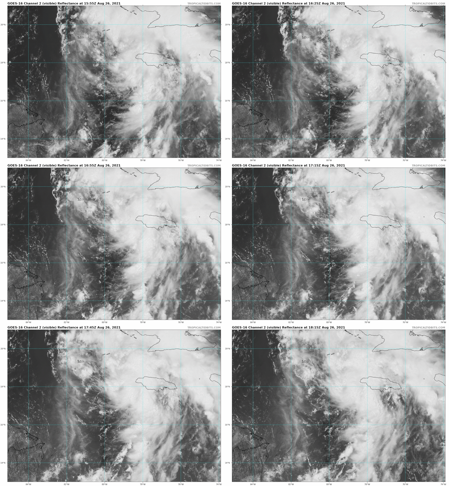
gatorcane wrote:Looks like this is going to be a problem for somebody along the northern Gulf coast. LA cannot catch a break it seems though still time for some shifts:

https://i.postimg.cc/QMNLtWXh/goes16-vis-09-L-202108261555.gif


WTH? is that an eye forming????
0 likes   

User avatar
cycloneye
Admin
Admin
Posts: 145307
Age: 68
Joined: Thu Oct 10, 2002 10:54 am
Location: San Juan, Puerto Rico

Re: ATL: NINE - Tropical Depression - Discussion

#560 Postby cycloneye » Thu Aug 26, 2021 1:36 pm

A. 09L (NONAME)

B. 26/1730Z

C. 17.6N

D. 78.9W

E. FIVE/GOES-E

F. T2.5/2.5

G. IR/EIR/VIS

H. REMARKS...SYSTEM HAS CIRCULARLY DEFINED CLOUD LINES AROUND AN LLCC
THAT IS NEAR THE LARGE ACTIVE COLD OVERCAST RESULTING IN A SHEAR PATTERN
DT OF 2.0. ADDITIONALLY, ON VISIBLE SATELLITE IMAGERY THE DEEP ACTIVE
COLD CONVECTION CAN BE SEEN WRAPPING AROUND THE LLCC IN THE NW QUADRANT
INDICATING THE CORE HOLDING STRONG IN THE SHEAR ENVIRONMENT ALLOWING
AN OPPORTUNITY FOR FURTHER DEVELOPMENT. THE 24 HR TREND IS DEVELOPING
RESULTING MET TO BE 2.0 AND PT TO BE 2.5. FT IS BASED ON PT DUE TO CLOUD
FEATURES NOT BEING CLEAR CUT.

I. ADDL POSITIONS

NIL


...PATEL
0 likes   
Visit the Caribbean-Central America Weather Thread where you can find at first post web cams,radars
and observations from Caribbean basin members Click Here


Return to “2021”

Who is online

Users browsing this forum: No registered users and 5 guests