ATL: IDA - Remnants - Discussion
Moderator: S2k Moderators
-
MississippiWx

- S2K Supporter

- Posts: 1720
- Joined: Sat Aug 14, 2010 1:44 pm
- Location: Hattiesburg, Mississippi
Re: ATL: NINE - Tropical Depression - Discussion
That persistent mid-level circulation has won out it seems. It takes a couple of days for mid-level circulations to make it to the surface and it seems like it has done so with TD9. I would put the real center right at 18N 79.4W. This position is still .5 degrees north of the NHC 2PM position. All of this matters for eventual USA landfall position.
1 likes
This post is not an official forecast and should not be used as such. It is just the opinion of MississippiWx and may or may not be backed by sound meteorological data. It is not endorsed by any professional institution including storm2k.org. For Official Information please refer to the NHC and NWS products.
-
FormerNewtotex
- Tropical Low

- Posts: 27
- Joined: Tue Mar 16, 2021 11:41 am
Re: ATL: NINE - Tropical Depression - Discussion
The track seems somewhat similar to Ivan from 2004. Though Ivan did not his Louisiana the track past Jamaica and over the western tip of Cuba seems familiar though Ivan ended up hitting the Alabama coast
1 likes
Old account "Newtotex"
Most memorable tornadoes: 1997 & 2000 Tuscaloosa Tornadoes, 1998 Oak Grove Tornado
Hurricane Opal/Ivan/Katrina
Most memorable tornadoes: 1997 & 2000 Tuscaloosa Tornadoes, 1998 Oak Grove Tornado
Hurricane Opal/Ivan/Katrina
-
jaguars_22
- Category 2

- Posts: 629
- Joined: Tue Jun 20, 2017 2:26 pm
- Location: Victoria TX
Re: ATL: NINE - Tropical Depression - Discussion
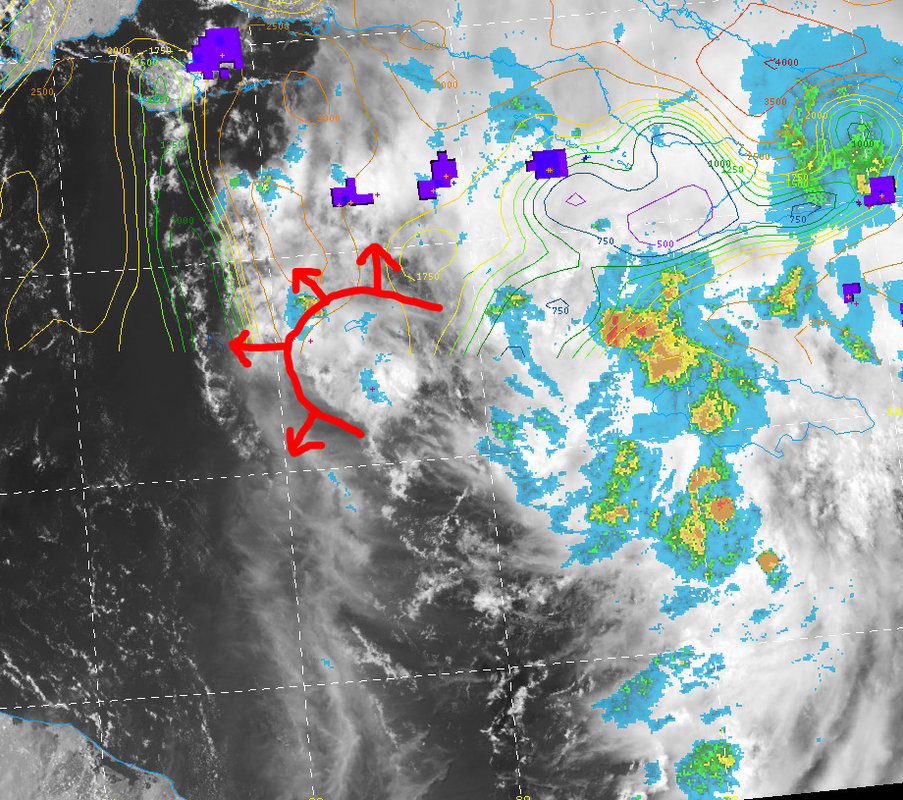
This thing does not look like it’s consolidating quick at all. It looks like it’s flowing south to north and spreading out? Is the upper low causing shear or what is?
0 likes

Re: ATL: NINE - Tropical Depression - Discussion
FormerNewtotex wrote:The track seems somewhat similar to Ivan from 2004. Though Ivan did not his Louisiana the track past Jamaica and over the western tip of Cuba seems familiar though Ivan ended up hitting the Alabama coast
Please no loopty loops and circle back to form a fujiwara effect with the 'GFS' Labor Day set up
0 likes
Once I see the REDS and GREENS Converge on a Base Velocity. ... I'm There!!
This is NOT an Official Forecast....Just my Opinion. For official information, please refer to the NHC and NWS products.
HIGHLIGHTS : '13 El Reno Tornado : 2013 Storm Chaser Tour, Joaquin; SC flood event, Matthew '16, Lowcountry Snow storm Jan '18
This is NOT an Official Forecast....Just my Opinion. For official information, please refer to the NHC and NWS products.
HIGHLIGHTS : '13 El Reno Tornado : 2013 Storm Chaser Tour, Joaquin; SC flood event, Matthew '16, Lowcountry Snow storm Jan '18
-
MississippiWx
- S2K Supporter
- Posts: 1720
- Joined: Sat Aug 14, 2010 1:44 pm
- Location: Hattiesburg, Mississippi
Re: ATL: NINE - Tropical Depression - Discussion
jaguars_22 wrote:This thing does not look like it’s consolidating quick at all. It looks like it’s flowing south to north and spreading out? Is the upper low causing shear or what is?
Looks like it's consolidating very well just off the Western tip of Jamaica. Shear is impacting the western side of the system a bit as the TUTT continues to fill and move out of the way. Outflow has slowly but surely expanded since yesterday. Upper level ridging should become well-established by tomorrow.
2 likes
This post is not an official forecast and should not be used as such. It is just the opinion of MississippiWx and may or may not be backed by sound meteorological data. It is not endorsed by any professional institution including storm2k.org. For Official Information please refer to the NHC and NWS products.
Re: ATL: NINE - Tropical Depression - Discussion
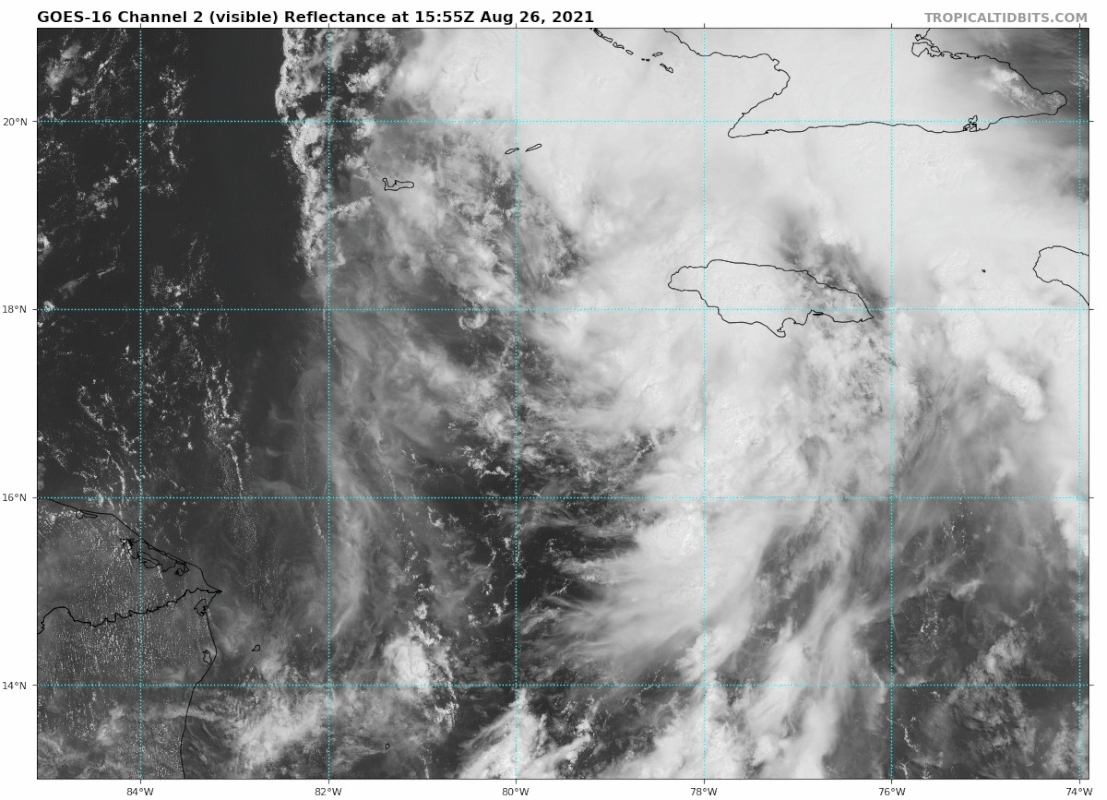
Stormgodess wrote:gatorcane wrote:Looks like this is going to be a problem for somebody along the northern Gulf coast. LA cannot catch a break it seems though still time for some shifts:
https://i.postimg.cc/QMNLtWXh/goes16-vis-09-L-202108261555.gif
WTH? is that an eye forming????
Don't believe so
1 likes

Re: ATL: NINE - Tropical Depression - Discussion
Stormgodess wrote:Category5Kaiju wrote:Jr0d wrote:...quotes from model thread...but did not want to clutter the forum with non model discussion...
I get that and meant to put a disclaimer in my post addressing the issue. That said, a direct hit on New Orleans would be worse from the overall humanitarian perspective. Other places can take along the gulf coast can take a direct hit much better and with a limited risk of lost lives, however it is still devastating for those who lose their homes.
With the vulnerable population and potential of levees failing, the storm missing New Orleans is a better scenario. Ideally the best outcome(besides a weak storm) would be for it to hit in sparsely populated areas, but again it is still bad for those who get hit.
Yeah, New Orleans is still visibly scarred from Katrina, so a major hurricane (let alone a 3 or 4) hitting the still-recovering city directly would be unbelievably devastating. And a 5? Yeah, I would rather not think about that.
And another thing... If evacuations from New Orleans start.... Its going to be hard for any of us to get anywhere unless we leave early.
That is the hardest part of all this every year for me. We live in an area that isnt on the coast but in the area north of lake maurepas typically far enough off coast to be safe, unless the conditions just right then we can get hit pretty bad. For us we never know until last minute if its bad enough to leave. Is it coming in at high tide? Our issue is river flooding. If the lakes have storm surge and the rivers cant drain we get flooding. Then whether or not it will be strong enough inland to do serious wind damage. We had trees down during both Katrina and Gustav. Flooding from Isaac and Major flooding in 2016. Even having all the info, I nevver know until last minute what to do and that kills me. Plus right now my daughter is about to have a baby any day now, and she also has a two yr old. Being stuck in a storm OR in evacuation traffic could be a serious situation
WXman57 called his sister in prairieville last night.
Many people don't know about the flood issues south of Baton Rouge.
Melancon's Café in Morganza is on higher ground.
https://www.youtube.com/watch?v=vZuFq4CfRR8
1 likes
-
FLpanhandle91

- Category 5

- Posts: 1039
- Age: 34
- Joined: Mon Sep 13, 2010 3:50 pm
- Location: Fort Walton Beach, FL
Re: ATL: NINE - Tropical Depression - Discussion
Just a quick tip for all of you. These formative stages of a TC are often a royal pain in the ass to decipher, pinpoint LLC, etc. You will see 5 differing opinions on these topics on one page alone. This is why recon is so unbelievably important in these types of scenarios. Just sit back and let the hurricane hunters decipher everything for you. Lol.
8 likes
Re: ATL: NINE - Tropical Depression - Discussion
Recon should be coming into it in another hour or so, currently in the Yucatan channel.
0 likes

Re: ATL: NINE - Tropical Depression - Discussion
This thing hasn't done anything all day.
Seeing small outflow boundaries from dry-air intrusion.
Seeing small outflow boundaries from dry-air intrusion.
1 likes
-
grapealcoholic
- Category 2
- Posts: 703
- Joined: Tue Aug 10, 2021 3:26 pm
Re: ATL: NINE - Tropical Depression - Discussion
wx98 wrote:Stormgodess wrote:gatorcane wrote:Looks like this is going to be a problem for somebody along the northern Gulf coast. LA cannot catch a break it seems though still time for some shifts:
https://i.postimg.cc/QMNLtWXh/goes16-vis-09-L-202108261555.gif
WTH? is that an eye forming????
Don't believe so
That's the LLC
0 likes
Re: ATL: NINE - Tropical Depression - Discussion
jaguars_22 wrote:This thing does not look like it’s consolidating quick at all. It looks like it’s flowing south to north and spreading out? Is the upper low causing shear or what is?
Not sure what you are seeing, but it looks like a TD with a nice structure building convection. Pretty much text book.
3 likes
Re: ATL: NINE - Tropical Depression - Discussion
GCANE wrote:This thing hasn't done anything all day.
Seeing small outflow boundaries from dry-air intrusion.
[url]https://i.postimg.cc/mDv3t4Kw/99L1.png [/url]
Those storms are right on the edge of the mid level dry air to the west. They suck some in, collapse and then puke out outflows.
0 likes
-
Stormgodess

- Category 1

- Posts: 316
- Joined: Mon Sep 14, 2020 1:31 am
Re: ATL: NINE - Tropical Depression - Discussion
Any one have link to a good SST Sea Surface temp map for the gulf handy??
0 likes
-
cycloneye

- Admin

- Posts: 149515
- Age: 69
- Joined: Thu Oct 10, 2002 10:54 am
- Location: San Juan, Puerto Rico
Re: ATL: NINE - Tropical Depression - Discussion
Breaking News
18z Best Track up to TS IDA.
AL, 09, 2021082618, BEST, 0, 177N, 794W, 35, 1004, TS
18z Best Track up to TS IDA.
AL, 09, 2021082618, BEST, 0, 177N, 794W, 35, 1004, TS
13 likes
Visit the Caribbean-Central America Weather Thread where you can find at first post web cams,radars
and observations from Caribbean basin members Click Here
and observations from Caribbean basin members Click Here
-
galaxy401

- Category 5
- Posts: 2446
- Age: 30
- Joined: Sat Aug 25, 2012 9:04 pm
- Location: Casa Grande, Arizona
Re: ATL: NINE - Tropical Depression - Discussion
Welcome to this year's I name. Looks like its reputation is going to continue...
3 likes
Got my eyes on moving right into Hurricane Alley: Florida.
Re: ATL: NINE - Tropical Depression - Discussion
To me, the west side of it looks pretty rough, with outflow boundaries being laid down as GCANE was pointing out and an appearance of dry air. I expect this to fix itself with time and organization. The big thing now is it appears the MLC is moving with a more easterly northward component and thus tugging the LLC with it, to the right of short term model guidance. Let's see if the 18z runs correct for this.
1 likes

Re: ATL: NINE - Tropical Depression - Discussion
FLpanhandle91 wrote:Just a quick tip for all of you. These formative stages of a TC are often a royal pain in the ass to decipher, pinpoint LLC, etc. You will see 5 differing opinions on these topics on one page alone. This is why recon is so unbelievably important in these types of scenarios. Just sit back and let the hurricane hunters decipher everything for you. Lol.
Well stated! Thank you.
1 likes
Houston, Texas. Allison '01, Rita '05, Dolly '08, Ike '08, Issac '12, Harvey '17
-
grapealcoholic
- Category 2
- Posts: 703
- Joined: Tue Aug 10, 2021 3:26 pm
Re: ATL: NINE - Tropical Depression - Discussion
wx98 wrote:To me, the west side of it looks pretty rough, with outflow boundaries being laid down as GCANE was pointing out and an appearance of dry air. I expect this to fix itself with time and organization. The big thing now is it appears the MLC is moving with a more easterly northward component and thus tugging the LLC with it, to the right of short term model guidance. Let's see if the 18z runs correct for this.
Looks stacked
0 likes
-
Stormgodess
- Category 1
- Posts: 316
- Joined: Mon Sep 14, 2020 1:31 am
Re: ATL: NINE - Tropical Depression - Discussion
cycloneye wrote:Breaking News
18z Best Track up to TS IDA.
AL, 09, 2021082618, BEST, 0, 177N, 794W, 35, 1004, TS
You might as well be speaking madarin
0 likes
Who is online
Users browsing this forum: No registered users and 19 guests