
Was feeling a tad better about Mississippi but given that this may be a bit stronger than models have it by the time it reaches cuba, and the fact that we are still 60-72 out from landfall a lot can happen. As stated ad nauseam in the board, if you are in the 72 hr cone prepare. Ultimately seems like a lock this will hit LA but a Houma landfall VS going up over Morgan city, New Iberia, and atchafalaya basin will have big impact New Orleans effects as well as Mississippi surge. And right side of the cone op should never feel safe with storms in that region.
Some indications that she may be a larger size storm…not really sure how we tell those things until it’s there, but that will also have an effect on how large a surge we see east of landfall, not to mention intensity. It’s worth noting that pretty much every cat 3+ to strike southeast La from the S or SE has carried a large surge. South central LA along the bays is obviously very surge prone too but dynamics are different and there is more marsh to protect some of the vulnerable communities. Only time will tell, but will be watching for any small adjustments today.
ATL: IDA - Remnants - Discussion
Moderator: S2k Moderators

-
tolakram
- Admin

- Posts: 20186
- Age: 62
- Joined: Sun Aug 27, 2006 8:23 pm
- Location: Florence, KY (name is Mark)
Re: ATL: IDA - Tropical Storm - Discussion
Next center pass soon

0 likes
M a r k
- - - - -
Join us in chat: Storm2K Chatroom Invite. Android and IOS apps also available.
The posts in this forum are NOT official forecasts and should not be used as such. Posts are NOT endorsed by any professional institution or STORM2K.org. For official information and forecasts, please refer to NHC and NWS products.
-
beoumont

- Category 1

- Posts: 473
- Joined: Sun Jul 10, 2011 4:13 pm
- Location: East Central Florida
- Contact:
Re: ATL: IDA - Tropical Storm - Discussion
A lot of Pine cones about to fall on the youth of the isle.

5 likes
List of 79 tropical cyclones intercepted by Richard Horodner:
http://www.canebeard.com/page/page/572246.htm
http://www.canebeard.com/page/page/572246.htm
-
ElectricStorm

- Category 5

- Posts: 5147
- Age: 25
- Joined: Tue Aug 13, 2019 11:23 pm
- Location: Norman, OK
Re: ATL: IDA - Tropical Storm - Discussion
Unfortunately it looks like none of the models really disrupt it much while crossing Cuba, and since it's already much better than anticipated, I don't really think Cuba will have much of an effect on it. I'm starting to get that pit in the stomach feeling and I'm not liking it one bit.
Probably a good chance this could be the storm of the season in the Atlantic.
Probably a good chance this could be the storm of the season in the Atlantic.
14 likes
B.S Meteorology, University of Oklahoma '25
Please refer to the NHC, NWS, or SPC for official information.
Please refer to the NHC, NWS, or SPC for official information.
-
PTrackerLA

- Category 5
- Posts: 5281
- Age: 42
- Joined: Thu Oct 10, 2002 8:40 pm
- Location: Lafayette, LA
Re: ATL: IDA - Tropical Storm - Discussion
Checking in from Lafayette, I hope everyone in my area and points east are taking Ida seriously. I'm afraid intensity forecasts will start ramping up given Ida's current appearance.
3 likes
-
TallyTracker
- Category 2

- Posts: 787
- Joined: Thu Oct 11, 2018 2:46 pm
Re: ATL: IDA - Tropical Storm - Discussion
I’m really concerned about Ida’s impacts in Louisiana. I have some cousins in Westwego I’m gonna check in with. This one has appears to have the makings of a big one unfortunately. 
2 likes
Fran '96, Georges '98, Gordon '00, Gabrielle '01, Charley '04, Frances '04, Jeanne '04, Barry '07, Fay '08, Debby '12, Matthew '16, Emily '17, Irma '17, Michael ‘18, Elsa ‘21, Fred ‘21, Mindy ‘21, Nicole ‘22, Idalia ‘23, Debby ‘24, Helene ‘24
-
BensonTCwatcher

- Category 5
- Posts: 1050
- Joined: Sat Aug 28, 2004 10:11 pm
- Location: Southport NC
Re: ATL: IDA - Tropical Storm - Discussion
Might see the center pulled a tad N based on the strong convection on this next pass. Lot of energy there
1 likes
-
SunnyThoughts
- Category 5
- Posts: 2263
- Joined: Wed Jul 09, 2003 12:42 pm
- Location: Pensacola, Florida
Re: ATL: IDA - Tropical Storm - Discussion
Wouldn't surprise me at all should they find hurricane force winds on this pass through the center.
0 likes

Re: ATL: IDA - Tropical Storm - Discussion
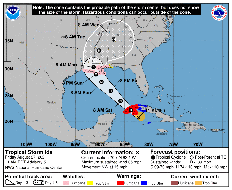
...IDA CONTINUES TO STRENGTHEN...
...HURRICANE WARNING ISSUED FOR THE ISLE OF YOUTH AND WESTERN
CUBA...
SUMMARY OF 1100 AM EDT...1500 UTC...INFORMATION
-----------------------------------------------
LOCATION...20.7N 82.1W
ABOUT 75 MI...125 KM SE OF THE ISLE OF YOUTH
ABOUT 200 MI...320 KM ESE OF THE WESTERN TIP OF CUBA
MAXIMUM SUSTAINED WINDS...65 MPH...100 KM/H
PRESENT MOVEMENT...NW OR 320 DEGREES AT 15 MPH...24 KM/H
MINIMUM CENTRAL PRESSURE...996 MB...29.42 INCHES
1 likes
-
catskillfire51
- S2K Supporter

- Posts: 480
- Age: 39
- Joined: Sun Aug 26, 2012 5:40 pm
- Location: Lake Jackson, TX
Re: ATL: IDA - Tropical Storm - Discussion
Curious how low the pressure is going to be, seems it’s already much lower on approach.
0 likes
-
Hypercane_Kyle

- Category 5
- Posts: 3465
- Joined: Sat Mar 07, 2015 7:58 pm
- Location: Cape Canaveral, FL
Re: ATL: IDA - Tropical Storm - Discussion
Now expected to be a hurricane upon reaching Cuba, peak intensity bumped to 105 knots.
6 likes
My posts are my own personal opinion, defer to the National Hurricane Center (NHC) and other NOAA products for decision making during hurricane season.
-
tolakram
- Admin
- Posts: 20186
- Age: 62
- Joined: Sun Aug 27, 2006 8:23 pm
- Location: Florence, KY (name is Mark)
Re: ATL: IDA - Tropical Storm - Discussion
000
WTNT44 KNHC 271449
TCDAT4
Tropical Storm Ida Discussion Number 5
NWS National Hurricane Center Miami FL AL092021
1100 AM EDT Fri Aug 27 2021
Radar imagery from Grand Cayman and Cuba as well as satellite data
continue to show an improvement in Ida's overall structure this
morning, with an increase in banding, the development of a small
central dense overcast, and more recently an improved inner-core
feature. Both the NOAA and Air Force reconnaissance aircraft
reported that the pressure has fallen to around 996 mb, and the Air
Force plane has measured flight-level and SFMR winds that support
an initial intensity of 55 kt.
Although there is still some southwesterly shear over Ida, the
outflow has begun to expand over the northeastern and southeastern
portions of the circulation. The upper-level trough near the
Yucatan peninsula that has been imparting the shear over Ida is
forecast to weaken and move westward during the next 12 to 24
hours, which should result in a more favorable upper-level
wind pattern. This, in combination with warm sea surface
temperatures and a moist environment along the forecast track of
the storm are expected to result in steady to rapid strengthening.
Ida is now foreast to become a hurricane when it is near western
Cuba and once it moves over the southeastern Gulf of Mexico a period
of rapid strengthening is likely to begin, with the NHC intensity
forecast explicitly calling for rapid intensification to major
hurricane strength between 24 and 48 hours. The official intensity
forecast is on the higher side of the intensity guidance but not
quite as high as the slightly more aggressive CTCI, HWRF, and HCCA
models. In addition to the increase in strength, the dynamical
model guidance indicates that Ida's wind field will grow larger as
it moves over the Gulf of Mexico and this is reflected in the NHC
wind radii forecast. In summary, there is a higher-than-normal
confidence that a significant hurricane will impact a large portion
of the northern Gulf coast by late this weekend and early next week.
Ida is moving northwestward or 320/13 kt. The track forecast
reasoning is unchanged from before. A mid-level ridge over the
western Atlantic is forecast to move westward and this should keep
Ida on a general northwestward heading during the next 48-60 hours.
This track will bring the storm across western Cuba later today,
over the southeastern and central Gulf of Mexico on Saturday and
Saturday night, to the coast of Louisiana by late Sunday. The
track guidance is in remarkably good agreement with very little
cross-track spread during the first 60 hours or so of the forecast
period. After that time, Ida is forecast to reach the western
portion of the ridge, which is expected to cause the storm to slow
down and turn northward and then northeastward over the
southeastern United States. The NHC track forecast is near or
just east of the various consensus aids, in best agreement with the
GFS ensemble mean. Although the small spread in the guidance
through landfall increases the overall confidence in the track
forecast, users are reminded to not focus on the exact details of
the forecast track as storm surge, wind, and rainfall impacts will
extend far from the center.
Key Messages:
1. Life-threatening storm surge and hurricane conditions are
expected later today and tonight in portions of western Cuba,
including the Isle of Youth, where a Hurricane Warning is in effect.
Life-threatening heavy rains, flash flooding and mudslides are
expected across Jamaica, the Cayman Islands, and western Cuba,
including the Isle of Youth.
2. The risk of life-threatening storm surge inundation is increasing
along the coasts of Louisiana, Mississippi, and Alabama. Inundation
of 7 to 11 feet above ground level is possible within the area from
Morgan City, Louisiana, to Ocean Springs, Mississippi, including
Lake Borgne. Interests in these areas should follow any advice given
by local officials.
3. Ida is expected to be a dangerous major hurricane when it reaches
the northern Gulf Coast on Sunday, and the risk of hurricane-force
winds continues to increase, especially along portions of the
Louisiana coast, including metropolitan New Orleans. Potentially
devastating wind damage could occur where the core of Ida moves
onshore.
4. Ida is likely to produce heavy rainfall later Sunday into Monday
across the central Gulf Coast from southeast Louisiana to coastal
Mississippi and Alabama, as well as the Lower Mississippi Valley,
resulting in considerable flash, urban, small stream, and riverine
flooding.
FORECAST POSITIONS AND MAX WINDS
INIT 27/1500Z 20.7N 82.1W 55 KT 65 MPH
12H 28/0000Z 22.2N 83.7W 65 KT 75 MPH...OVER WESTERN CUBA
24H 28/1200Z 24.0N 85.8W 75 KT 85 MPH...OVER WATER
36H 29/0000Z 25.9N 87.8W 90 KT 105 MPH
48H 29/1200Z 27.6N 89.7W 105 KT 120 MPH
60H 30/0000Z 29.0N 90.8W 105 KT 120 MPH
72H 30/1200Z 30.3N 91.3W 60 KT 70 MPH...INLAND
96H 31/1200Z 33.3N 90.2W 30 KT 35 MPH...INLAND
120H 01/1200Z 35.2N 87.1W 20 KT 25 MPH...POST-TROP/REMNT LOW
$$
Forecaster Brown
4 likes
M a r k
- - - - -
Join us in chat: Storm2K Chatroom Invite. Android and IOS apps also available.
The posts in this forum are NOT official forecasts and should not be used as such. Posts are NOT endorsed by any professional institution or STORM2K.org. For official information and forecasts, please refer to NHC and NWS products.
- - - - -
Join us in chat: Storm2K Chatroom Invite. Android and IOS apps also available.
The posts in this forum are NOT official forecasts and should not be used as such. Posts are NOT endorsed by any professional institution or STORM2K.org. For official information and forecasts, please refer to NHC and NWS products.
Re: ATL: IDA - Tropical Storm - Discussion
Do they really think it’s going to stay at 105 kts for 12 hours?
3 likes
-
FormerNewtotex
- Tropical Low

- Posts: 27
- Joined: Tue Mar 16, 2021 11:41 am
Re: ATL: IDA - Tropical Storm - Discussion
I'm curious what the terrain of SC/SE Louisiana will have on post-landfall intensity. I'm sure most people are aware that this area is shallow marshland, then add in Lake Pontchartrain & Lake Maurepas, there really isn't the same land interaction to weaken the storm quickly like you would have in coastal MS/AL/nw FL. This is more like far south Florida & the Everglades.
1 likes
Old account "Newtotex"
Most memorable tornadoes: 1997 & 2000 Tuscaloosa Tornadoes, 1998 Oak Grove Tornado
Hurricane Opal/Ivan/Katrina
Most memorable tornadoes: 1997 & 2000 Tuscaloosa Tornadoes, 1998 Oak Grove Tornado
Hurricane Opal/Ivan/Katrina
-
FLpanhandle91

- Category 5
- Posts: 1039
- Age: 34
- Joined: Mon Sep 13, 2010 3:50 pm
- Location: Fort Walton Beach, FL
-
Shell Mound
- Category 5
- Posts: 2432
- Age: 33
- Joined: Thu Sep 07, 2017 3:39 pm
- Location: St. Petersburg, FL → Scandinavia
Re: ATL: IDA - Tropical Storm - Discussion
Hypercane_Kyle wrote:Now expected to be a hurricane upon reaching Cuba, peak intensity bumped to 105 knots.
I’m a little surprised that the MSW don’t change between the 48h and 60h positions, given that the most recent global models suggest deepening up until LF. On the other hand, the HWRF shows some hints of southwesterly mid-level shear around the time of landfall, with an IR presentation similar to Laura’s: restricted outflow in the western hemisphere (half) and weaker convective returns in the southeastern quadrant. Beginning just after 48h, the HWRF shows Ida’s structure becoming increasingly asymmetric, its MSLP gradually deepening at a slower pace than earlier and eventually becoming steady-state around the time of LF.
Fancy1001 wrote:Do they really think it’s going to stay at 105 kts for 12 hours?

Westerly shear?
4 likes
CVW / MiamiensisWx / Shell Mound
The posts in this forum are NOT official forecasts and should not be used as such. They are just the opinion of the poster and may or may not be backed by sound meteorological data. They are NOT endorsed by any professional institution or STORM2K. For official information, please refer to products from the NHC and NWS.
-
weeniepatrol

- Category 5
- Posts: 1343
- Joined: Sat Aug 22, 2020 5:30 pm
- Location: WA State
Re: ATL: IDA - Tropical Storm - Discussion
So um, recon is extrapolating 999mb with 50kt FL winds 
1 likes
Who is online
Users browsing this forum: No registered users and 29 guests