ATL: IDA - Remnants - Discussion
Moderator: S2k Moderators
-
AlabamaDave
- Tropical Storm

- Posts: 169
- Joined: Wed Aug 11, 2004 6:44 pm
Re: ATL: IDA - Tropical Storm - Discussion
Are there any good analogs for a major hurricane on this track as far as impacts on the New Orleans area? I was kind of thinking Betsy, but she was on a sharper NW trajectory with no curve around to the north when she hit SE Louisiana, and also the center passed closer to the city. Then I thought about Andrew, and the angle of approach is pretty similar, but he made landfall a bit west of current projections. I don't recall Andrew causing dramatic impacts for NOLA. Certainly not trying to downplay, but am wondering whether the current track, with the center crossing over Baton Rouge, would likely spare NOLA from much beyond Cat-1 winds and storm surge outside the levees and sea walls. IF it follows the exact NHC track forecast right now. I know flooding in the city from excessive rainfall will also be a major problem no matter where this lands.
Last edited by AlabamaDave on Fri Aug 27, 2021 10:30 am, edited 1 time in total.
2 likes

Re: ATL: IDA - Tropical Storm - Discussion
PavelGaborik wrote:What is the terrain like where she's going over in Cuba? Is it possible she could take slightly longer to reorganize her core when she enters the gulf later today since she's ahead of schedule organization wise or is that wishful thinking?
While not impossible, I'm afraid it's most likely wishful thinking. Western Cuba is known to do pretty much nothing to disrupt TCs. Of all the TCs to pass over this section of Cuba from south to north (55 since 1851), only Isbell and unnamed hurricanes in 1915, 1886 and 1882 went down a category. The others survived this section of Cuba without a lot of trouble and maintained intensity (examples are Lili, Ike, 1917 Nueva Gerona). Multiple hurricanes such as the 1948 Miami hurricane even intensified over land.

Last edited by kevin on Fri Aug 27, 2021 10:31 am, edited 1 time in total.
7 likes

Re: ATL: IDA - Tropical Storm - Discussion
wxman57 wrote:PTPatrick wrote:Was feeling a tad better about Mississippi but given that this may be a bit stronger than models have it by the time it reaches cuba, and the fact that we are still 60-72 out from landfall a lot can happen. As stated ad nauseam in the board, if you are in the 72 hr cone prepare. Ultimately seems like a lock this will hit LA but a Houma landfall VS going up over Morgan city, New Iberia, and atchafalaya basin will have big impact New Orleans effects as well as Mississippi surge. And right side of the cone op should never feel safe with storms in that region.
Some indications that she may be a larger size storm…not really sure how we tell those things until it’s there, but that will also have an effect on how large a surge we see east of landfall, not to mention intensity. It’s worth noting that pretty much every cat 3+ to strike southeast La from the S or SE has carried a large surge. South central LA along the bays is obviously very surge prone too but dynamics are different and there is more marsh to protect some of the vulnerable communities. Only time will tell, but will be watching for any small adjustments today.
Ignore the cone, it's completely meaningless as far as impacts (just average track error past 5 yrs). Where are you in MS? I expect maybe 5-7 ft tides into the coast Sunday pm, putting water over Highway 90. TS winds east to BIloxi Sunday pm. Rainfall 5-10 inches on the coast. As for size, looks average in size. Hurricane force winds only maybe 35-40 miles from center vs. about 125 for Katrina. TS winds out to about 150 miles from center = about average or very slightly above average.
I understand the cone is not effects…didn’t mean to imply otherwise. Yeah that’s about what I’d expect as far as Mississippi effects as well. Haven’t delved into the forecast radii though so thanks for that info…glad it’s not as large as I was thinking they meant. I am not in Mississippi but family all through the area from Gulfport to Mobile, many along the water/bayous so surge is something I have watched closely over the years. My gut feeling is that current track and intensity holds, 7 is about right around Biloxi , but any wiggle east and it could get into the 10 ft range quickly over there. My ancestral homeland near the bayous on the MS/AL state line goes under water around 6-8 feet(depending on where you are in the yard). So feeling good with current forecast 4-7, Family is currently hatching their evac plan just in case though. This one could be close if it hugs right side of guidance.
Last edited by PTPatrick on Fri Aug 27, 2021 10:33 am, edited 2 times in total.
2 likes
-
Shell Mound
- Category 5

- Posts: 2432
- Age: 33
- Joined: Thu Sep 07, 2017 3:39 pm
- Location: St. Petersburg, FL → Scandinavia
Re: ATL: IDA - Tropical Storm - Discussion
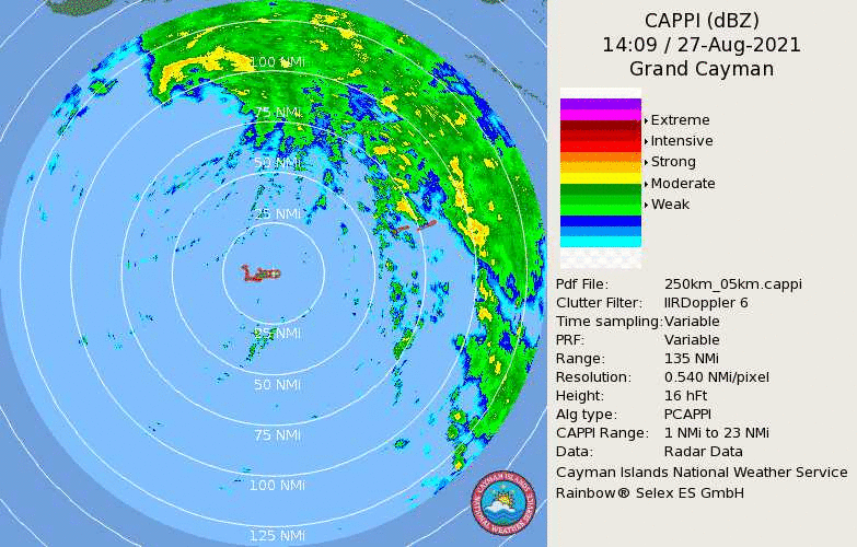
RL3AO wrote:Shell Mound wrote:Owasso wrote:https://i.postimg.cc/BZxQWWxc/250km-cappi.gif
Looks to be rapidly closing up
It also looks to be tracking significantly farther east than even the HWRF. At this rate the formative eye could just “scrape” the easternmost Isla de la Juventud.
Does seem like the island may catch the weaker side of the storm.
https://i.imgur.com/A24tSdS.png

Source (bold red dot indicates estimated position of centre based on recon and Cuban radar, white dotted line[s] past and extrapolated movement)
1 likes
CVW / MiamiensisWx / Shell Mound
The posts in this forum are NOT official forecasts and should not be used as such. They are just the opinion of the poster and may or may not be backed by sound meteorological data. They are NOT endorsed by any professional institution or STORM2K. For official information, please refer to products from the NHC and NWS.
-
skyline385

- Category 5
- Posts: 2728
- Age: 35
- Joined: Wed Aug 26, 2020 11:15 pm
- Location: Houston TX
Re: ATL: IDA - Tropical Storm - Discussion
Wow when you have ICON showing a landfall of 950mb, that's bad
2 likes

Re: ATL: IDA - Tropical Storm - Discussion
Pressure looks to be down to 991mb where the LLC has seemingly finally aligned with the MLC, 5mb lower than the NHC’s 11am advisory pressure. I didn’t expect it to get this well organized this fast before the Gulf. Since it’ll likely be in the 980-990mb range upon entering the Gulf, the maximum possible intensity only got higher.
0 likes
Irene '11 Sandy '12 Hermine '16 5/15/2018 Derecho Fay '20 Isaias '20 Elsa '21 Henri '21 Ida '21
I am only a meteorology enthusiast who knows a decent amount about tropical cyclones. Look to the professional mets, the NHC, or your local weather office for the best information.
I am only a meteorology enthusiast who knows a decent amount about tropical cyclones. Look to the professional mets, the NHC, or your local weather office for the best information.
-
grapealcoholic
- Category 2

- Posts: 703
- Joined: Tue Aug 10, 2021 3:26 pm
Re: ATL: IDA - Tropical Storm - Discussion
AlabamaDave wrote:Are there any good analogs for a major hurricane on this track as far as impacts on the New Orleans area? I was kind of thinking Betsy, but she was on a sharper NW trajectory with no curve around to the north when she hit SE Louisiana, and also the center passed closer to the city. Then I thought about Andrew, and the angle of approach is pretty similar, but he made landfall a bit west of current projections. I don't recall Andrew causing dramatic impacts for NOLA. Certainly not trying to downplay, but am wondering whether the current track, with the center crossing over Baton Rouge, would likely spare NOLA from much beyond Cat-1 winds and storm surge outside the levees and sea walls. IF it follows the exact NHC track forecast right now. I know flooding in the city from excessive rainfall will also be a major problem no matter where this lands.
Camille
0 likes


Re: ATL: IDA - Tropical Storm - Discussion
Seeing rotating lightning strikes.
Looks like eyewall building.
Looks like eyewall building.
0 likes
Re: ATL: IDA - Tropical Storm - Discussion
Shell Mound wrote:Owasso wrote:https://i.postimg.cc/BZxQWWxc/250km-cappi.gif
Looks to be rapidly closing up
It also looks to be tracking significantly farther east than even the HWRF. At this rate the formative eye could just “scrape” the easternmost Isla de la Juventud.
Definitely seems like there was a bit of a reformation/snap of the center towards the deeper convection, which was (and still is) mostly on the northern side.
1 likes
I'm a busy grad student, not a professional forecaster. Please refer to the NHC and NWS for official forecasts.


-
AlabamaDave
- Tropical Storm
- Posts: 169
- Joined: Wed Aug 11, 2004 6:44 pm
Re: ATL: IDA - Tropical Storm - Discussion
kevin wrote:While not impossible, I'm afraid it's most likely wishful thinking. Western Cuba is known to do pretty much nothing to disrupt TCs. Of all the TCs to pass over this section of Cuba from south to north (55 since 1851), only Isbell and unnamed hurricanes in 1915, 1886 and 1882 went down a category. The others survived this section of Cuba without a lot of trouble and maintained intensity (examples are Lili, Ike, 1917 Nueva Gerona). Multiple hurricanes such as the 1948 Miami hurricane even intensified over land.
Yep, if you pull up a terrain map of western Cuba on Google Maps, the highest mountains in that part of Cuba top out around 1,500 feet. Really just big hills.
0 likes
Re: ATL: IDA - Tropical Storm - Discussion
PavelGaborik wrote:What is the terrain like where she's going over in Cuba? Is it possible she could take slightly longer to reorganize her core when she enters the gulf later today since she's ahead of schedule organization wise or is that wishful thinking?
West Cuba never seems to matter, the hills aren't that high and it is maybe 40 miles across. It will probably flatten out the wind field a bit and make the ts strength winds expand into the gulf.
1 likes

Re: ATL: IDA - Tropical Storm - Discussion
cheezyWXguy wrote:psyclone wrote:26% odds of hurricane force winds in the big easy on the latest advisory. Those wind probs are going up fast as confidence increases in a big impact
Agreed. Icon just ran and shifted east with a stronger landfall, and it still initialized 14mb too weak, meaning this may be slightly too far west. Not good for the city.
Hello, City of New Orleans? Might be a good time to order pump parts same day delivery via Amazon Prime
12 likes
Andy D
(For official information, please refer to the NHC and NWS products.)
(For official information, please refer to the NHC and NWS products.)
-
grapealcoholic
- Category 2
- Posts: 703
- Joined: Tue Aug 10, 2021 3:26 pm
Re: ATL: IDA - Tropical Storm - Discussion
ThetaE wrote:Shell Mound wrote:Owasso wrote:https://i.postimg.cc/BZxQWWxc/250km-cappi.gif
Looks to be rapidly closing up
It also looks to be tracking significantly farther east than even the HWRF. At this rate the formative eye could just “scrape” the easternmost Isla de la Juventud.
Definitely seems like there was a bit of a reformation/snap of the center towards the deeper convection, which was (and still is) mostly on the northern side.
It's right at the gfs predicted spot though
1 likes
-
AlabamaDave
- Tropical Storm
- Posts: 169
- Joined: Wed Aug 11, 2004 6:44 pm
Re: ATL: IDA - Tropical Storm - Discussion
grapealcoholic wrote:AlabamaDave wrote:Are there any good analogs for a major hurricane on this track as far as impacts on the New Orleans area? I was kind of thinking Betsy, but she was on a sharper NW trajectory with no curve around to the north when she hit SE Louisiana, and also the center passed closer to the city. Then I thought about Andrew, and the angle of approach is pretty similar, but he made landfall a bit west of current projections. I don't recall Andrew causing dramatic impacts for NOLA. Certainly not trying to downplay, but am wondering whether the current track, with the center crossing over Baton Rouge, would likely spare NOLA from much beyond Cat-1 winds and storm surge outside the levees and sea walls. IF it follows the exact NHC track forecast right now. I know flooding in the city from excessive rainfall will also be a major problem no matter where this lands.
Camille
But Camille went east of New Orleans, although wow. The track is eerily similar other than that!
0 likes

Re: ATL: IDA - Tropical Storm - Discussion

 :
:MississippiWx wrote:One different (and concerning) thing about Ida than hurricanes from last season is that some models seem to slow it down after landfall. Flooding could be a very major problem in Louisiana and Mississippi.
I noticed that on a model I was watching. It looked like Ida
decided to come ashore and sit a spell. MS/NO.
0 likes
Re: ATL: IDA - Tropical Storm - Discussion
Partial eyewall visible on Key west radar.
2 likes
Personal Forecast Disclaimer:
The posts in this forum are NOT official forecast and should not be used as such. They are just the opinion of the poster and may or may not be backed by sound meteorological data. For official information, please refer to the NHC and NWS products.
The posts in this forum are NOT official forecast and should not be used as such. They are just the opinion of the poster and may or may not be backed by sound meteorological data. For official information, please refer to the NHC and NWS products.
-
Shell Mound
- Category 5
- Posts: 2432
- Age: 33
- Joined: Thu Sep 07, 2017 3:39 pm
- Location: St. Petersburg, FL → Scandinavia
Re: ATL: IDA - Tropical Storm - Discussion
ThetaE wrote:Shell Mound wrote:Owasso wrote:https://i.postimg.cc/BZxQWWxc/250km-cappi.gif
Looks to be rapidly closing up
It also looks to be tracking significantly farther east than even the HWRF. At this rate the formative eye could just “scrape” the easternmost Isla de la Juventud.
Definitely seems like there was a bit of a reformation/snap of the center towards the deeper convection, which was (and still is) mostly on the northern side.
Given the current rate of intensification Ida could conceivably approach MH status at LF on western Cuba. I think 80–90 kt/970–975 mb seems quite likely, given the observed rate of deepening and organisation observed by radar, satellite, and reconnaissance. Ida’s current track, along with its relocated centre, would minimise interaction with the Isla de la Juventud and would maximise the storm’s time over the Gulf of Batabanó prior to landfall on the Cuban mainland. If I recall correctly, the most aggressive model run to date only suggested that Ida would approach ~70 kt/~985 mb at landfall on western Cuba. Ida currently looks to be at least 10 kt/mb stronger than that by the time it impacts western Cuba.
AlabamaDave wrote:grapealcoholic wrote:AlabamaDave wrote:Are there any good analogs for a major hurricane on this track as far as impacts on the New Orleans area? I was kind of thinking Betsy, but she was on a sharper NW trajectory with no curve around to the north when she hit SE Louisiana, and also the center passed closer to the city. Then I thought about Andrew, and the angle of approach is pretty similar, but he made landfall a bit west of current projections. I don't recall Andrew causing dramatic impacts for NOLA. Certainly not trying to downplay, but am wondering whether the current track, with the center crossing over Baton Rouge, would likely spare NOLA from much beyond Cat-1 winds and storm surge outside the levees and sea walls. IF it follows the exact NHC track forecast right now. I know flooding in the city from excessive rainfall will also be a major problem no matter where this lands.
Camille
But Camille went east of New Orleans, although wow. The track is eerily similar other than that!
I am growing increasingly concerned that Ida could take a track similar to the 1947 hurricane or Betsy but feature a LF intensity comparable to Michael’s.
2 likes
CVW / MiamiensisWx / Shell Mound
The posts in this forum are NOT official forecasts and should not be used as such. They are just the opinion of the poster and may or may not be backed by sound meteorological data. They are NOT endorsed by any professional institution or STORM2K. For official information, please refer to products from the NHC and NWS.
-
grapealcoholic
- Category 2
- Posts: 703
- Joined: Tue Aug 10, 2021 3:26 pm
Re: ATL: IDA - Tropical Storm - Discussion
Adios recon. Hopefully we have another plane arrive in time to provide data for the 5pm advisory.
1 likes
Irene '11 Sandy '12 Hermine '16 5/15/2018 Derecho Fay '20 Isaias '20 Elsa '21 Henri '21 Ida '21
I am only a meteorology enthusiast who knows a decent amount about tropical cyclones. Look to the professional mets, the NHC, or your local weather office for the best information.
I am only a meteorology enthusiast who knows a decent amount about tropical cyclones. Look to the professional mets, the NHC, or your local weather office for the best information.
Who is online
Users browsing this forum: No registered users and 23 guests