ATL: IDA - Remnants - Discussion
Moderator: S2k Moderators
-
grapealcoholic
- Category 2

- Posts: 703
- Joined: Tue Aug 10, 2021 3:26 pm
Re: ATL: IDA - Hurricane - Discussion
With the inner core now being closed, that secondary band is going to get squeezed for momentum. Might see it slide away
0 likes

Re: ATL: IDA - Hurricane - Discussion
Clearcloudz wrote:Evcauation Traffic on I 10
https://i.imgur.com/9COQhvL.jpg
https://i.imgur.com/rGT38RA.jpg
https://i.imgur.com/wFFQCwC.jpg
https://i.imgur.com/3uH3kHd.jpg
https://i.imgur.com/gULkEXu.jpg
Just another day down in Red Stick when it comes to traffic
5 likes

Re: ATL: IDA - Hurricane - Discussion
panamatropicwatch wrote:Station 42039 (LLNR 115) - PENSACOLA - 115NM SSE of Pensacola, FL and 188 miles north of Ida reporting sustained winds of 31kts gusts to 38.9kts.
That’s scary hopefully just in a small area and not a large area that would pile up the surge. Yeah traffic is always bad during rush hour but that a little worse and it’s Saturday. I really wish people learn to take more of the surface streets. We don’t have a lot of ways out but if know your area you can avoid some of this.
Last edited by tailgater on Sat Aug 28, 2021 4:57 pm, edited 1 time in total.
1 likes
The following post is NOT an official forecast and should not be used as such. It is just the opinion of the poster and may or may not be backed by sound meteorological data. It is NOT endorsed by any professional institution including storm2k.org For Official Information please refer to the NHC and NWS products.
-
jasons2k

- Storm2k Executive

- Posts: 8290
- Age: 52
- Joined: Wed Jul 06, 2005 12:32 pm
- Location: The Woodlands, TX
Re: ATL: IDA - Hurricane - Discussion
I just can't underplay how dangerous this storm is going to be. I have been concerned about the NOLA metro area all along and I'm very concerned about the levees. I haven't changed my thinking since Thursday evening. This slight rightward/poleward-of-forecast path while undergoing deepening and moving across the gulf is what I expected to see.
The storm has spent the day strengthening at a pretty good clip, and now we are about to hit nighttime with a trek across the loop current. I see nothing to keep Ida from undergoing a sustained period of RI right up to landfall. The only inhibiting factors I see are time and the possibility of an ERC. The recon reports during the overnight are going to stun some folks.
The storm has spent the day strengthening at a pretty good clip, and now we are about to hit nighttime with a trek across the loop current. I see nothing to keep Ida from undergoing a sustained period of RI right up to landfall. The only inhibiting factors I see are time and the possibility of an ERC. The recon reports during the overnight are going to stun some folks.
20 likes
-
Craters
- Category 1

- Posts: 428
- Joined: Sat Aug 24, 2013 2:34 pm
- Location: Alvin, TX (south of Houston)
Re: ATL: IDA - Hurricane - Discussion Update= 5 PM =105 mph
tolakram wrote:Outflow boundary firing in the eye a few minutes ago. These loops from SLIDER, which has been having issues but still the best for some of these loops.
https://i.imgur.com/TpeD5w6.gif
Was Nora supposed to go inland?
https://imgur.com/CLlXZNf
Well, by the looks of that loop, Nora and Ida should end up colliding somewhere near the panhandle of Texas.
3 likes
Nothing that I post here should ever be treated as a forecast or anything resembling one. Please check with your local NWS office or the NHC for forecasts, watches, and warnings.
-
Hurrilurker

- Category 2
- Posts: 738
- Joined: Mon Jun 09, 2003 3:32 pm
- Location: San Francisco, CA
-
ElectricStorm

- Category 5

- Posts: 5147
- Age: 25
- Joined: Tue Aug 13, 2019 11:23 pm
- Location: Norman, OK
Re: ATL: IDA - Hurricane - Discussion
jasons2k wrote:I just can't underplay how dangerous this storm is going to be. I have been concerned about the NOLA metro area all along and I'm very concerned about the levees. I haven't changed my thinking since Thursday evening. This slight rightward/poleward-of-forecast path while undergoing deepening and moving across the gulf is what I expected to see.
The storm has spent the day strengthening at a pretty good clip, and now we are about to hit nighttime with a trek across the loop current. I see nothing to keep Ida from undergoing a sustained period of RI right up to landfall. The only inhibiting factors I see are time and the possibility of an ERC. The recon reports during the overnight are going to stun some folks.
Exactly what I'm thinking pretty much word for word
2 likes
B.S Meteorology, University of Oklahoma '25
Please refer to the NHC, NWS, or SPC for official information.
Please refer to the NHC, NWS, or SPC for official information.

Re: ATL: IDA - Hurricane - Discussion
Product: NOAA Vortex Message (URNT12 KWBC)
Transmitted: 28th day of the month at 21:40Z
Agency: National Oceanic and Atmospheric Administration (NOAA)
Aircraft: Lockheed WP-3D Orion (Reg. Num. N42RF)
Storm Name: Ida
Storm Number & Year: 09 in 2021 (flight in the North Atlantic basin)
Mission Number: 10
Observation Number: 05
A. Time of Center Fix: 28th day of the month at 21:13:29Z
B. Center Fix Coordinates: 26.13N 87.08W
B. Center Fix Location: 298 statute miles (480 km) to the S (178°) from Pensacola, FL, USA.
C. Minimum Height at Standard Level: 2,867m (9,406ft) at 700mb
D. Minimum Sea Level Pressure: 974mb (28.77 inHg)
E. Dropsonde Surface Wind at Center: From 225° at 10kts (From the SW at 12mph)
F. Eye Character: Closed
G. Eye Shape & Diameter: Circular with a diameter of 25 nautical miles (29 statute miles)
H. Estimated (by SFMR or visually) Maximum Surface Wind Inbound: 79kts (90.9mph)
I. Location & Time of the Estimated Maximum Surface Wind Inbound: 23 nautical miles (26 statute miles) to the ENE (57°) of center fix at 21:07:15Z
J. Maximum Flight Level Wind Inbound: From 145° at 91kts (From the SE at 104.7mph)
K. Location & Time of the Maximum Flight Level Wind Inbound: 26 nautical miles (30 statute miles) to the NE (54°) of center fix at 21:06:07Z
L. Estimated (by SFMR or visually) Maximum Surface Wind Outbound: 70kts (80.6mph)
M. Location & Time of the Estimated Maximum Surface Wind Outbound: 19 nautical miles (22 statute miles) to the SW (219°) of center fix at 21:18:16Z
N. Maximum Flight Level Wind Outbound: From 297° at 63kts (From the WNW at 72.5mph)
O. Location & Time of the Maximum Flight Level Wind Outbound: 17 nautical miles (20 statute miles) to the SW (219°) of center fix at 21:17:45Z
P. Maximum Flight Level Temp & Pressure Altitude Outside Eye: 10°C (50°F) at a pressure alt. of 3,053m (10,016ft)
Q. Maximum Flight Level Temp & Pressure Altitude Inside Eye: 15°C (59°F) at a pressure alt. of 3,062m (10,046ft)
R. Dewpoint Temp (collected at same location as temp inside eye): 10°C (50°F)
R. Sea Surface Temp (collected at same location as temp inside eye): Not Available
S. Fix Determined By: Penetration, Radar, Wind, Pressure and Temperature
S. Fix Level: 700mb
T. Navigational Fix Accuracy: 0.01 nautical miles
T. Meteorological Accuracy: 1 nautical mile
Remarks Section - Remarks That Were Decoded...
Maximum Flight Level Wind: 91kts (~ 104.7mph) which was observed 26 nautical miles (30 statute miles) to the NE (54°) from the flight level center at 21:06:07Z
Remarks Section - Additional Remarks...
SEC MAX FL WIND 75 KT BRNG:042 deg RNG:67 nm
General Note About Vortex Messages:
- SFMR and flight level winds are usually averaged over a 10 second period. (The National Hurricane Center's advisory wind speeds are the highest expected winds averaged over a 1 minute period.)
0 likes
-
PavelGaborik
- Tropical Depression

- Posts: 81
- Joined: Thu Oct 06, 2016 11:13 pm
Re: ATL: IDA - Hurricane - Discussion
Hurrilurker wrote:That eye just refuses to clear out.
To be fair it's likely just a low end Hurricane based on the recon data, no winds even supporting low end category 2 at the moment.
2 likes
-
Hypercane_Kyle

- Category 5
- Posts: 3465
- Joined: Sat Mar 07, 2015 7:58 pm
- Location: Cape Canaveral, FL
Re: ATL: IDA - Hurricane - Discussion
CDO cloudtops are definitely starting to cool over the last few frames.
1 likes
My posts are my own personal opinion, defer to the National Hurricane Center (NHC) and other NOAA products for decision making during hurricane season.
-
HurryKane

- Category 5
- Posts: 1941
- Joined: Sun Sep 12, 2004 8:08 pm
- Location: Diamondhead, Mississippi
Re: ATL: IDA - Hurricane - Discussion
Clearcloudz wrote:https://twitter.com/mattlanza/status/1431711014203047939
So, it’s easy to point fingers and get fired up when the NOLA mayor says that the required 72 hours to pull off a mandatory evacuation meant they didn’t have time to do it…
…just note that the first advisory from the NHC on then-TD9 was issued just *55 HOURS* ago at 1100 EDT on Thursday. That’s how short the lifetime of this storm has been for the majority of the public and for what public safety planners can work with in terms of getting the public to take them seriously. 72 hours before the first impacts would have meant issuing a mandatory evacuation for that first NHC advisory…i.e. for a tropical depression.
Last edited by HurryKane on Sat Aug 28, 2021 5:01 pm, edited 1 time in total.
6 likes
-
PavelGaborik
- Tropical Depression
- Posts: 81
- Joined: Thu Oct 06, 2016 11:13 pm
Re: ATL: IDA - Hurricane - Discussion
Hypercane_Kyle wrote:CDO cloudtops are definitely starting to cool over the last few frames.
It's been trying this all day, we'll see if it manages to keep them for an extended period of time now.
It's over very warm waters now, let's see what happens.
0 likes

Re: ATL: IDA - Hurricane - Discussion
That leading edge tower on the SW eyewall looks good, but not really seeing any type of cirrus stacking or gravity waves.
I am seeing 3000 CAPE in the core. Last drop in the eye showed it was highly saturated.
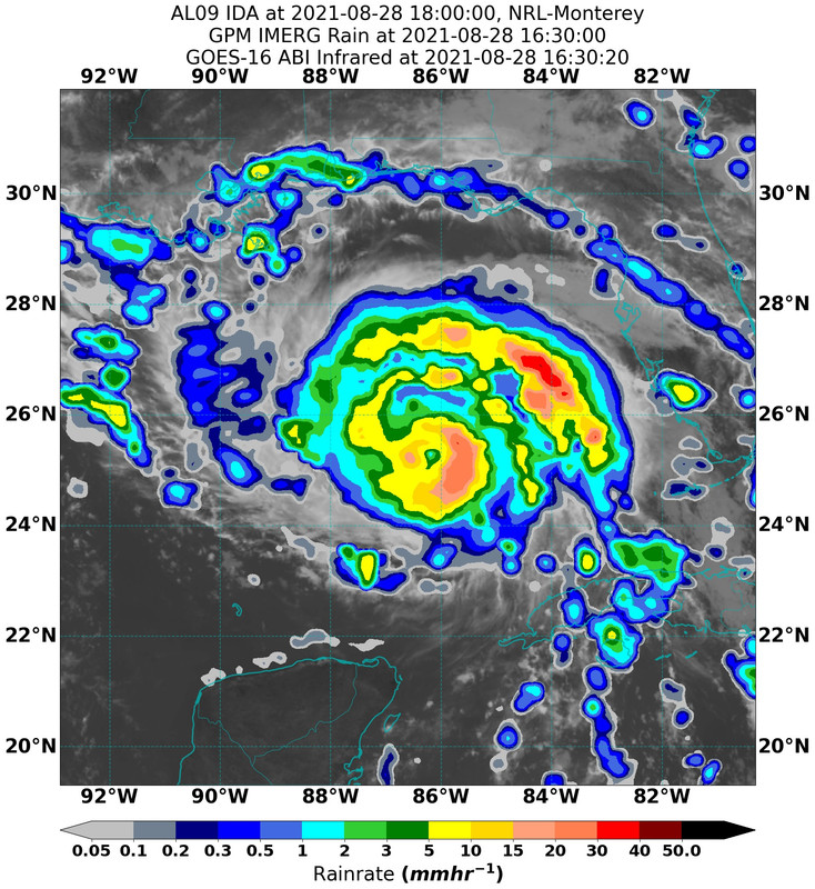
Rain rate was 28 mm/hr in the eyewall.
AMSU thermal profile shows a very long vertical warm core with hardly any cold pool beneath it.
It needs to take advantage of the cooling upper troposphere tonight to create a high lapse rate for any chance of RI to occur.
Maybe 50/50, let's see.
I am seeing 3000 CAPE in the core. Last drop in the eye showed it was highly saturated.
Rain rate was 28 mm/hr in the eyewall.
AMSU thermal profile shows a very long vertical warm core with hardly any cold pool beneath it.
It needs to take advantage of the cooling upper troposphere tonight to create a high lapse rate for any chance of RI to occur.
Maybe 50/50, let's see.
3 likes
-
PavelGaborik
- Tropical Depression
- Posts: 81
- Joined: Thu Oct 06, 2016 11:13 pm

Re: ATL: IDA - Hurricane - Discussion

0 likes
Once I see the REDS and GREENS Converge on a Base Velocity. ... I'm There!!
This is NOT an Official Forecast....Just my Opinion. For official information, please refer to the NHC and NWS products.
HIGHLIGHTS : '13 El Reno Tornado : 2013 Storm Chaser Tour, Joaquin; SC flood event, Matthew '16, Lowcountry Snow storm Jan '18
This is NOT an Official Forecast....Just my Opinion. For official information, please refer to the NHC and NWS products.
HIGHLIGHTS : '13 El Reno Tornado : 2013 Storm Chaser Tour, Joaquin; SC flood event, Matthew '16, Lowcountry Snow storm Jan '18
Re: ATL: IDA - Hurricane - Discussion
Still just moderate rain rate. Nothing approaching high end.
It is struggling to warm up the core.
 ebay image hosting
It is struggling to warm up the core.
ebay image hosting
1 likes
-
grapealcoholic
- Category 2
- Posts: 703
- Joined: Tue Aug 10, 2021 3:26 pm
Re: ATL: IDA - Hurricane - Discussion
PavelGaborik wrote:Is that a large dry slot to the NW?
Yes, moat between banding features
0 likes
-
MGC

- S2K Supporter

- Posts: 5940
- Joined: Sun Mar 23, 2003 9:05 pm
- Location: Pass Christian MS, or what is left.
Re: ATL: IDA - Hurricane - Discussion
Ida investing its energy in expanding it wind field. Katrina did the same thing before RI. Surge forecast likely to increase. Risk increasing for NOLA to be in eyewall. Another Betsy for SE LA.....MGC
2 likes
-
CrazyC83
- Professional-Met

- Posts: 34315
- Joined: Tue Mar 07, 2006 11:57 pm
- Location: Deep South, for the first time!
Re: ATL: IDA - Hurricane - Discussion
If this somehow fails to intensify as much as forecast, I can guarantee you that there will be scientific studies on it. However, it's just over the maximum Loop Current now. The next 12 hours are critical.
Also, if it starts to ramp up, it will probably be rapidly intensifying right up to landfall.
Also, if it starts to ramp up, it will probably be rapidly intensifying right up to landfall.
11 likes
Who is online
Users browsing this forum: No registered users and 37 guests