ATL: IDA - Remnants - Discussion
Moderator: S2k Moderators
-
grapealcoholic
- Category 2

- Posts: 703
- Joined: Tue Aug 10, 2021 3:26 pm


Re: ATL: IDA - Hurricane - Discussion
GCANE wrote:Still just moderate rain rate. Nothing approaching high end.
It is struggling to warm up the core.
[url]https://i.postimg.cc/V6Wgwbp6/20210828-163000-AL092021-imerg-GPM-Rain-90kts-39p4-1p0.jpg [/url]ebay image hosting
Still, I will be quite surprised if this fails to exceed 110 kt with a combo of a now closed eyewall, 30-31C SSTs, low shear, and entering the Loop Current as diurnal warming weakens.
4 likes
Irene '11 Sandy '12 Hermine '16 5/15/2018 Derecho Fay '20 Isaias '20 Elsa '21 Henri '21 Ida '21
I am only a meteorology enthusiast who knows a decent amount about tropical cyclones. Look to the professional mets, the NHC, or your local weather office for the best information.
I am only a meteorology enthusiast who knows a decent amount about tropical cyclones. Look to the professional mets, the NHC, or your local weather office for the best information.
-
PavelGaborik
- Tropical Depression

- Posts: 81
- Joined: Thu Oct 06, 2016 11:13 pm
Re: ATL: IDA - Hurricane - Discussion
grapealcoholic wrote:Bombing.
Looks like more slow, steady intensification to me.
0 likes

Re: ATL: IDA - Hurricane - Discussion
FWIW 18z GFS drops it 13 mb's at LF compared to 12z
0 likes
Once I see the REDS and GREENS Converge on a Base Velocity. ... I'm There!!
This is NOT an Official Forecast....Just my Opinion. For official information, please refer to the NHC and NWS products.
HIGHLIGHTS : '13 El Reno Tornado : 2013 Storm Chaser Tour, Joaquin; SC flood event, Matthew '16, Lowcountry Snow storm Jan '18
This is NOT an Official Forecast....Just my Opinion. For official information, please refer to the NHC and NWS products.
HIGHLIGHTS : '13 El Reno Tornado : 2013 Storm Chaser Tour, Joaquin; SC flood event, Matthew '16, Lowcountry Snow storm Jan '18
-
Category5Kaiju

- Category 5

- Posts: 4335
- Joined: Thu Dec 24, 2020 12:45 pm
- Location: Seattle and Phoenix
Re: ATL: IDA - Hurricane - Discussion
aspen wrote:GCANE wrote:Still just moderate rain rate. Nothing approaching high end.
It is struggling to warm up the core.
[url]https://i.postimg.cc/V6Wgwbp6/20210828-163000-AL092021-imerg-GPM-Rain-90kts-39p4-1p0.jpg [/url]ebay image hosting
Still, I will be quite surprised if this fails to exceed 110 kt with a combo of a now closed eyewall, 30-31C SSTs, low shear, and entering the Loop Current as diurnal warming weakens.
Me too; if it does not intensify like that then I am pretty sure extensive research will need to be done in the future to figure out why nearly every known factor was favorable but still resulted in a sluggish storm. Factor X that caused the storm to not intensify and struggle would need to be solved for. Although I am willing to bet that in the end we will be looking at a powerful Hurricane.
2 likes
Unless explicitly stated, all info in my posts is based on my own opinions and observations. Tropical storms and hurricanes can be extremely dangerous. Refer to an accredited weather research agency or meteorologist if you need to make serious decisions regarding an approaching storm.

Re: ATL: IDA - Hurricane - Discussion
That dry slot may inhibit RI over the next couple of hours. It will.be interesting to see how much a pressure drop we will see between center passed.
0 likes
Re: ATL: IDA - Hurricane - Discussion

minus that moat to the w looking stout
Last edited by Kohlecane on Sat Aug 28, 2021 5:22 pm, edited 1 time in total.
1 likes
Once I see the REDS and GREENS Converge on a Base Velocity. ... I'm There!!
This is NOT an Official Forecast....Just my Opinion. For official information, please refer to the NHC and NWS products.
HIGHLIGHTS : '13 El Reno Tornado : 2013 Storm Chaser Tour, Joaquin; SC flood event, Matthew '16, Lowcountry Snow storm Jan '18
This is NOT an Official Forecast....Just my Opinion. For official information, please refer to the NHC and NWS products.
HIGHLIGHTS : '13 El Reno Tornado : 2013 Storm Chaser Tour, Joaquin; SC flood event, Matthew '16, Lowcountry Snow storm Jan '18
-
grapealcoholic
- Category 2
- Posts: 703
- Joined: Tue Aug 10, 2021 3:26 pm

Re: ATL: IDA - Hurricane - Discussion
Craters wrote:If you're lurking and reading this thread to help you decide whether to stay in a location that could feel strong effects from Hurricane Ida, please allow me to bring up a few things that might help you make up your mind.
Don't forget the utter fun of a week without power in August in Louisiana!
3 likes
Baton Rouge area cyclone dilettante, PSWAGGER* tropical weather & hydrology model developer
(* Pseudo-Scientific Wild-A** Guesses Generally Expressed Ridiculously)
The GFDL would've had all this figured out by now.
(* Pseudo-Scientific Wild-A** Guesses Generally Expressed Ridiculously)
The GFDL would've had all this figured out by now.
-
Category5Kaiju
- Category 5
- Posts: 4335
- Joined: Thu Dec 24, 2020 12:45 pm
- Location: Seattle and Phoenix
Re: ATL: IDA - Hurricane - Discussion
Jr0d wrote:That dry slot may inhibit RI over the next couple of hours. It will.be interesting to see how much a pressure drop we will see between center passed.
Idk, at least imho that dry spot may be extremely transient given the otherwise very solid and robust overall structure of the storm, and I just don’t know how much of an impact in the grand scheme of things that would have, doesn’t seem like it will make or break Ida
1 likes
Unless explicitly stated, all info in my posts is based on my own opinions and observations. Tropical storms and hurricanes can be extremely dangerous. Refer to an accredited weather research agency or meteorologist if you need to make serious decisions regarding an approaching storm.
Re: ATL: IDA - Hurricane - Discussion
GCANE wrote:CAPE has increased now to 3500 in the core.
shrug off that other poster nullifying your CAPE interpretations.
I have learned over the years that there is indeed a correlation between RI and CAPE values.
and I thank you for bringing that correlation to the board.
17 likes
-
Shell Mound
- Category 5
- Posts: 2432
- Age: 33
- Joined: Thu Sep 07, 2017 3:39 pm
- Location: St. Petersburg, FL → Scandinavia
Re: ATL: IDA - Hurricane - Discussion
So far FL winds and SFMR do not support MSW higher than ~80 kt in the NE quadrant. If the winds don’t “catch up” and/or mix down, surge could be reduced a bit.
0 likes
CVW / MiamiensisWx / Shell Mound
The posts in this forum are NOT official forecasts and should not be used as such. They are just the opinion of the poster and may or may not be backed by sound meteorological data. They are NOT endorsed by any professional institution or STORM2K. For official information, please refer to products from the NHC and NWS.
-
StormTracker

- S2K Supporter

- Posts: 2909
- Age: 59
- Joined: Thu Jun 29, 2006 6:06 am
- Location: Quail Heights(Redlands), FL.
Re: ATL: IDA - Hurricane - Discussion
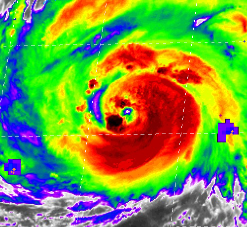
Hurrilurker wrote:That eye just refuses to clear out.
But when it does...
0 likes
Something's wrong when you regret, things that haven't happened yet!

Re: ATL: IDA - Hurricane - Discussion
Clearcloudz wrote:Evcauation Traffic on I 10
https://i.imgur.com/9COQhvL.jpg
https://i.imgur.com/rGT38RA.jpg
https://i.imgur.com/wFFQCwC.jpg
https://i.imgur.com/3uH3kHd.jpg
https://i.imgur.com/gULkEXu.jpg
Near my home. These are all looking westbound.
0 likes
-
PavelGaborik
- Tropical Depression
- Posts: 81
- Joined: Thu Oct 06, 2016 11:13 pm
Re: ATL: IDA - Hurricane - Discussion
Anyone else beginning to get vibes from another storm from 2008?
Conditions aren't going to get much better than they are right now.
Conditions aren't going to get much better than they are right now.
1 likes
Re: ATL: IDA - Hurricane - Discussion
jdjaguar wrote:GCANE wrote:CAPE has increased now to 3500 in the core.
shrug off that other poster nullifying your CAPE interpretations.
I have learned over the years that there is indeed a correlation between RI and CAPE values.
and I thank you for bringing that correlation to the board.
Yeah much appreciated, never correlated it with TC's doing analysis, I use it all the time for set up's when doing my Skywarn spotting
0 likes
Once I see the REDS and GREENS Converge on a Base Velocity. ... I'm There!!
This is NOT an Official Forecast....Just my Opinion. For official information, please refer to the NHC and NWS products.
HIGHLIGHTS : '13 El Reno Tornado : 2013 Storm Chaser Tour, Joaquin; SC flood event, Matthew '16, Lowcountry Snow storm Jan '18
This is NOT an Official Forecast....Just my Opinion. For official information, please refer to the NHC and NWS products.
HIGHLIGHTS : '13 El Reno Tornado : 2013 Storm Chaser Tour, Joaquin; SC flood event, Matthew '16, Lowcountry Snow storm Jan '18
-
ElectricStorm

- Category 5
- Posts: 5147
- Age: 25
- Joined: Tue Aug 13, 2019 11:23 pm
- Location: Norman, OK
Re: ATL: IDA - Hurricane - Discussion
PavelGaborik wrote:Anyone else beginning to get vibes from another storm from 2008?
Conditions aren't going to get much better than they are right now.
It's been over the loop current for maybe an hour max. It's not like it's going to bomb to Cat 4 as soon as it touches it lol
1 likes
B.S Meteorology, University of Oklahoma '25
Please refer to the NHC, NWS, or SPC for official information.
Please refer to the NHC, NWS, or SPC for official information.
-
tropicwatch

- Category 5
- Posts: 3426
- Age: 62
- Joined: Sat Jun 02, 2007 10:01 am
- Location: The Villages, Florida
- Contact:
Re: ATL: IDA - Hurricane - Discussion
Looks like Ida is about done with the dry air intrusion. Let the games begin 

4 likes
Tropicwatch
Agnes 72', Eloise 75, Elena 85', Kate 85', Charley 86', Florence 88', Beryl 94', Dean 95', Erin 95', Opal 95', Earl 98', Georges 98', Ivan 2004', Arlene 2005', Dennis 2005', Ida 2009' Debby 2012' Irma 2017' Michael 2018'
Agnes 72', Eloise 75, Elena 85', Kate 85', Charley 86', Florence 88', Beryl 94', Dean 95', Erin 95', Opal 95', Earl 98', Georges 98', Ivan 2004', Arlene 2005', Dennis 2005', Ida 2009' Debby 2012' Irma 2017' Michael 2018'
Who is online
Users browsing this forum: No registered users and 33 guests