ATL: IDA - Remnants - Discussion

Moderator: S2k Moderators

Message
Author
User avatar
johngaltfla
Category 5
Category 5
Posts: 2065
Joined: Sun Jul 10, 2005 9:17 pm
Location: Sarasota County, FL
Contact:

Re: ATL: IDA - Hurricane - Discussion

#2701 Postby johngaltfla » Sat Aug 28, 2021 7:05 pm

SEASON_CANCELED wrote:
johngaltfla wrote:
Shell Mound wrote:https://twitter.com/NowItsMidnight/status/1431764768168333313

Disclaimer: this may or may not be true, but if the latter...how did this end up happening?


Which of course is where our barges full of gasoline come from for Western Florida. I sincerely hope for the crew's sake they get out and haul some arse out of there soon!


I wouldn't worry those ships move at 20kts. They will get out of there soon enough im sure


We don't need any environmental disasters on top of the nightmare of Ida's hit either.
5 likes   

User avatar
aspen
Category 5
Category 5
Posts: 8812
Joined: Sat Oct 12, 2019 7:10 pm
Location: Connecticut, USA

Re: ATL: IDA - Hurricane - Discussion

#2702 Postby aspen » Sat Aug 28, 2021 7:07 pm

I’m starting to get doubtful that Ida will make it to Category 4 intensity. Its current structure seems primed for an EWRC or just other competing bands to slow down intensification, with the exception of short bursts.

That does NOT mean it isn’t a huge threat. The very large radius of hurricane-force FL winds (and TS-H surface winds) in the NE quadrant means places on the east side of landfall, like New Orleans, are at risk for lots of storm surge. 7-11 feet is really bad. Hopefully the post-Katrina leeve improvements do their job well.
5 likes   
Irene '11 Sandy '12 Hermine '16 5/15/2018 Derecho Fay '20 Isaias '20 Elsa '21 Henri '21 Ida '21

I am only a meteorology enthusiast who knows a decent amount about tropical cyclones. Look to the professional mets, the NHC, or your local weather office for the best information.

User avatar
ScottNAtlanta
Category 5
Category 5
Posts: 2360
Joined: Sat May 25, 2013 3:11 pm
Location: Atlanta, GA

Re: ATL: IDA - Hurricane - Discussion

#2703 Postby ScottNAtlanta » Sat Aug 28, 2021 7:07 pm

Kermit looks to have dropped back to 10,000 feet so I doubt they are headed back if they dropped to operational altitude.
2 likes   
The posts in this forum are NOT official forecast and should not be used as such. They are just the opinion of the poster and may or may not be backed by sound meteorological data. They are NOT endorsed by any professional institution or storm2k.org. For official information, please refer to the NHC and NWS products.

caneseddy
Category 5
Category 5
Posts: 1172
Joined: Fri Sep 03, 2004 9:31 pm
Location: Plantation, FL

Re: ATL: IDA - Hurricane - Discussion

#2704 Postby caneseddy » Sat Aug 28, 2021 7:09 pm

Dave Bernard on Fox 8 just had a frustrated rant about the reconnaissance planes having to abort twice today which he says has been happening since last year and that it is not acceptable that with such a major storm heading towards land the planes are having to abort the missions
6 likes   

User avatar
robbielyn
Category 5
Category 5
Posts: 1298
Joined: Wed May 07, 2003 9:45 am
Location: brooksville, fl

Re: ATL: IDA - Hurricane - Discussion

#2705 Postby robbielyn » Sat Aug 28, 2021 7:09 pm

SEASON_CANCELED wrote:
catskillfire51 wrote:
StormPyrate wrote:
Agreed, the mute button is quite effective


I'm sorry this could be the most important piece of information, how do you mute people?


Add Foe in their profile should mute them

never knew i could do this. i’ve been here for 18 years!! thank you!! Ida sure worrisome for LA. I wish for everyone’s safety. be careful with generators. watch out for gators and venomous snakes and downed power lines and drive safe!!!
2 likes   
Robbielyn McCrary
I know just about enough to sound like I know what I'm talking about sometimes. But for your safety please follow the nhc for truly professional forecasting. :D

PandaCitrus
Category 1
Category 1
Posts: 424
Joined: Mon Sep 04, 2017 2:44 pm

Re: ATL: IDA - Hurricane - Discussion

#2706 Postby PandaCitrus » Sat Aug 28, 2021 7:09 pm

1 likes   

tolakram
Admin
Admin
Posts: 19990
Age: 61
Joined: Sun Aug 27, 2006 8:23 pm
Location: Florence, KY (name is Mark)

Re: ATL: IDA - Hurricane - Discussion

#2707 Postby tolakram » Sat Aug 28, 2021 7:10 pm

Everyone,

STAY ON TOPIC PLEASE. Thanks to all of those who reported posts, much appreciated!
7 likes   
M a r k
- - - - -
Join us in chat: Storm2K Chatroom Invite. Android and IOS apps also available.

The posts in this forum are NOT official forecasts and should not be used as such. Posts are NOT endorsed by any professional institution or STORM2K.org. For official information and forecasts, please refer to NHC and NWS products.

User avatar
gatorcane
S2K Supporter
S2K Supporter
Posts: 23689
Age: 47
Joined: Sun Mar 13, 2005 3:54 pm
Location: Boca Raton, FL

Re: ATL: IDA - Hurricane - Discussion

#2708 Postby gatorcane » Sat Aug 28, 2021 7:14 pm


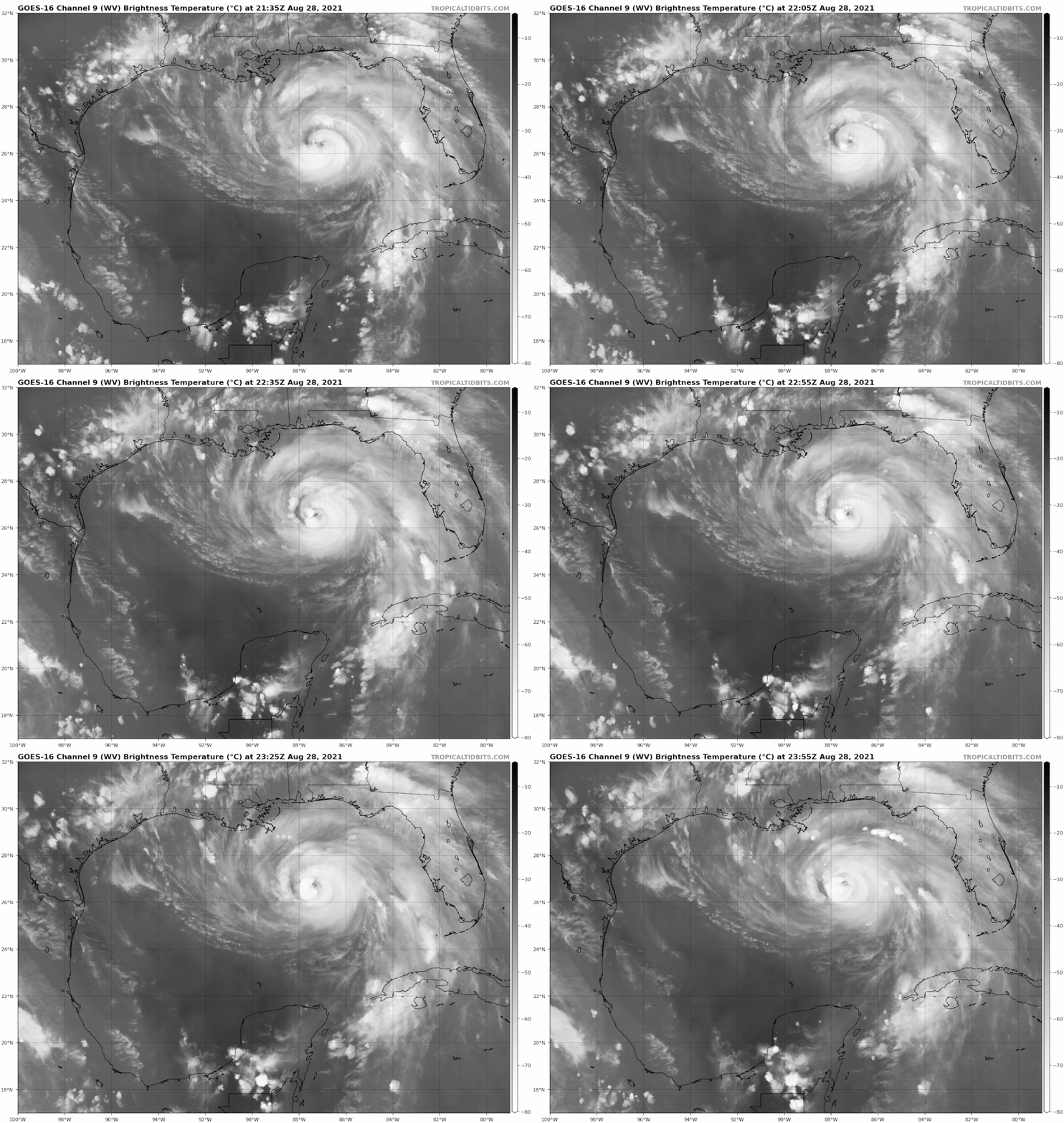
You can see the upper-level low spinning in the Western Gulf (25N, 95W) in this water vapor loop. Look for the counter-clockwise spin:

Image
Last edited by gatorcane on Sat Aug 28, 2021 7:16 pm, edited 1 time in total.
4 likes   

User avatar
SEASON_CANCELED
Category 3
Category 3
Posts: 887
Joined: Mon Jul 06, 2009 5:17 am
Location: 8 Bit Charlie Sheen

Re: ATL: IDA - Hurricane - Discussion

#2709 Postby SEASON_CANCELED » Sat Aug 28, 2021 7:16 pm

gatorcane wrote:


You can see the upper-level low spinning in the Western Gulf in this water vapor loop. Look for the counter-clockwise spin:

https://i.postimg.cc/NMRd2BG6/goes16-wv-mid-gom.gif


look at the towers on bands rising

I think this is gonna be rough tommorrow in terms of intensity
1 likes   
i am a big stupid ugly moron with an ugly face and a big butt and my butt stinks and i like to kiss my own butt

User avatar
ElectricStorm
Category 5
Category 5
Posts: 5017
Age: 24
Joined: Tue Aug 13, 2019 11:23 pm
Location: Skiatook, OK / Norman, OK

Re: ATL: IDA - Hurricane - Discussion

#2710 Postby ElectricStorm » Sat Aug 28, 2021 7:20 pm

aspen wrote:I’m starting to get doubtful that Ida will make it to Category 4 intensity. Its current structure seems primed for an EWRC or just other competing bands to slow down intensification, with the exception of short bursts.

That does NOT mean it isn’t a huge threat. The very large radius of hurricane-force FL winds (and TS-H surface winds) in the NE quadrant means places on the east side of landfall, like New Orleans, are at risk for lots of storm surge. 7-11 feet is really bad. Hopefully the post-Katrina leeve improvements do their job well.

I still think Cat 4 is still possible but it looks like my 130kt+ prediction from yesterday is going to bust pretty bad. Still looks to be pretty close to the NHC forecast but if it doesn't reach major status before the next advisory it's going to be falling behind a bit. That certainly doesn't change the fact it's going to be awful though and I'm definitely praying for everyone involved. Heck even if it landfalled at it's current intensity it would still be a nightmare.

I really hope I'm wrong and this doesn't get much stronger than it does now.
1 likes   
I am in no way a professional. Take what I say with a grain of salt as I could be totally wrong. Please refer to the NHC, NWS, or SPC for official information.

Boomer Sooner!

tolakram
Admin
Admin
Posts: 19990
Age: 61
Joined: Sun Aug 27, 2006 8:23 pm
Location: Florence, KY (name is Mark)

Re: ATL: IDA - Hurricane - Discussion

#2711 Postby tolakram » Sat Aug 28, 2021 7:20 pm

Everything you read on the internet is true!

In the meantime, NOAA plane heading for another center pass.

Image

 https://twitter.com/michaelmbell/status/1431767318493728772


9 likes   
M a r k
- - - - -
Join us in chat: Storm2K Chatroom Invite. Android and IOS apps also available.

The posts in this forum are NOT official forecasts and should not be used as such. Posts are NOT endorsed by any professional institution or STORM2K.org. For official information and forecasts, please refer to NHC and NWS products.

User avatar
Highteeld
Category 5
Category 5
Posts: 2139
Age: 41
Joined: Tue Jan 30, 2018 9:10 pm
Location: Chicago

Re: ATL: IDA - Hurricane - Discussion

#2712 Postby Highteeld » Sat Aug 28, 2021 7:22 pm

Looks pretty ugly on satellite. that said, it's probably getting stronger still. this storm seems to have an inverse relationship with aesthetic appeal and observed intensity.
5 likes   
Very useful information on the Dvorak Technique --

https://severe.worldweather.wmo.int/TCF ... kBeven.pdf

User avatar
Kohlecane
Category 2
Category 2
Posts: 591
Age: 33
Joined: Sun Jul 31, 2011 11:03 pm
Location: Beaufort, SC

Re: ATL: IDA - Hurricane - Discussion

#2713 Postby Kohlecane » Sat Aug 28, 2021 7:23 pm


Kohlecane wrote:Sorry images are easy loops I can never figure out lol
https://weather.cod.edu/satrad/?parms=r ... =undefined
ULWV the ULL over the W.GOM does not to be moving much at all IMO, and the Ridge over the SE doesn't seem incredibly strong ATM IMAO :lol:
With a potential RI incoming I can see why a potential E shift.
Also might have missed this in other posts but does the Poleward and horizontal rule just not as likely with this set up :?:

Im gonna start doing my own tweets :D
1 likes   
Once I see the REDS and GREENS Converge on a Base Velocity. ... I'm There!!

This is NOT an Official Forecast....Just my Opinion. For official information, please refer to the NHC and NWS products.
HIGHLIGHTS : '13 El Reno Tornado : 2013 Storm Chaser Tour, Joaquin; SC flood event, Matthew '16, Lowcountry Snow storm Jan '18

User avatar
CronkPSU
S2K Supporter
S2K Supporter
Posts: 2014
Joined: Sun Aug 07, 2005 10:44 pm
Location: Avalon Park, FL

Re: ATL: IDA - Hurricane - Discussion

#2714 Postby CronkPSU » Sat Aug 28, 2021 7:23 pm

2 likes   
Just like Jon Snow..."I know nothing" except what I know, and most of what I know is gathered by the fine people of the NHC

User avatar
KimmieLa
S2K Supporter
S2K Supporter
Posts: 99
Joined: Fri May 25, 2012 10:38 pm
Location: Baton Rouge, LA

Re: ATL: IDA - Hurricane - Discussion

#2715 Postby KimmieLa » Sat Aug 28, 2021 7:24 pm

facemane wrote:
hipshot wrote:
KimmieLa wrote:
Near my home. These are all looking westbound.

Looks like some headed east and some west, I think I would head west, at least get on the easier side of the storm if you don't get far enough.


yeah, the traffic is definitely eastbound at the I-10 and I-12 split.


Thanks y'all. I should have said the heavy traffic is heading west. Some cameras are pointing east and some west.
0 likes   

User avatar
GeneratorPower
S2K Supporter
S2K Supporter
Posts: 1648
Age: 45
Joined: Sun Dec 18, 2005 11:48 pm
Location: Huntsville, AL

Re: ATL: IDA - Hurricane - Discussion

#2716 Postby GeneratorPower » Sat Aug 28, 2021 7:24 pm

aspen wrote:I’m starting to get doubtful that Ida will make it to Category 4 intensity. Its current structure seems primed for an EWRC or just other competing bands to slow down intensification, with the exception of short bursts.

That does NOT mean it isn’t a huge threat. The very large radius of hurricane-force FL winds (and TS-H surface winds) in the NE quadrant means places on the east side of landfall, like New Orleans, are at risk for lots of storm surge. 7-11 feet is really bad. Hopefully the post-Katrina leeve improvements do their job well.


It’s on track for at least Cat 4 status.
0 likes   

User avatar
SEASON_CANCELED
Category 3
Category 3
Posts: 887
Joined: Mon Jul 06, 2009 5:17 am
Location: 8 Bit Charlie Sheen

Re: ATL: IDA - Hurricane - Discussion

#2717 Postby SEASON_CANCELED » Sat Aug 28, 2021 7:26 pm

GeneratorPower wrote:
aspen wrote:I’m starting to get doubtful that Ida will make it to Category 4 intensity. Its current structure seems primed for an EWRC or just other competing bands to slow down intensification, with the exception of short bursts.

That does NOT mean it isn’t a huge threat. The very large radius of hurricane-force FL winds (and TS-H surface winds) in the NE quadrant means places on the east side of landfall, like New Orleans, are at risk for lots of storm surge. 7-11 feet is really bad. Hopefully the post-Katrina leeve improvements do their job well.


It’s on track for at least Cat 4 status.


Yes it is. People saying its not looking good, consider that its moving in favorable waters and an intensification cycle is currently underway

There are 30 hours between the eyewall and land, plenty of time to blow up
1 likes   
i am a big stupid ugly moron with an ugly face and a big butt and my butt stinks and i like to kiss my own butt

User avatar
Steve
S2K Supporter
S2K Supporter
Posts: 9591
Joined: Sat Apr 05, 2003 11:41 pm
Location: Not a state-caster

Re: ATL: IDA - Hurricane - Discussion

#2718 Postby Steve » Sat Aug 28, 2021 7:26 pm

SEASON_CANCELED wrote:
Maryellen46 wrote:I went on the New Orleans subreddit…so many are staying :double: :(


Everyones got Covid fatigue and like i was saying, most of the Katrina generation left the city ages ago so the tragedy is not really much more than a footnote in history. Most of the memories are in Houston Texas and Birgmi


Word. Were it not for my family having to evacuate, I might have ridden it out. Jason Kelly - wxman007 (RIP brother) sent me a PM during Katrina pleading me to get out when I was undecided. But as long as Ida only brings 1 or 2 conditions to the city, id do it. But any hogs East and levee failures can kiss my ass. Glad to be in Pensacola any time I can be since my house is here.
5 likes   

floridasun78
Category 5
Category 5
Posts: 3755
Joined: Sun May 17, 2009 10:16 pm
Location: miami fl

Re: ATL: IDA - Hurricane - Discussion

#2719 Postby floridasun78 » Sat Aug 28, 2021 7:26 pm

let hope wind dont higher and 130mph
0 likes   

User avatar
Category5Kaiju
Category 5
Category 5
Posts: 4051
Joined: Thu Dec 24, 2020 12:45 pm
Location: Seattle

Re: ATL: IDA - Hurricane - Discussion

#2720 Postby Category5Kaiju » Sat Aug 28, 2021 7:27 pm

Idk, the way I see it it still looks quite healthy for an intensifying cyclone, and if it fails to achieve at least Cat 4 status then I would be very curious to know what factor caused this given the forecasts saw light shear, high RH, a path over the Loop Current, and all of these factors strongly suggest a powerful cyclone.
4 likes   
Unless explicitly stated, all info in my posts is based on my own opinions and observations. Tropical storms and hurricanes can be extremely dangerous. Do not think you can beat Mother Nature. Refer to an accredited weather research agency or meteorologist if you need to make serious decisions regarding an approaching storm.


Return to “2021”

Who is online

Users browsing this forum: No registered users and 36 guests