ATL: IDA - Remnants - Discussion

Moderator: S2k Moderators

Message
Author
User avatar
johngaltfla
Category 5
Category 5
Posts: 2069
Joined: Sun Jul 10, 2005 9:17 pm
Location: Sarasota County, FL
Contact:

Re: ATL: IDA - Hurricane - Discussion

#2941 Postby johngaltfla » Sat Aug 28, 2021 9:51 pm

jasons2k wrote:Checking-in after a Saturday high school football game. We had a nice easterly breeze and it was pleasantly mild - especially for an August football game.

As for Ida this trend is what I was expecting. I don’t really have much new to add. The Grand Isle area still looks like a good call to me. It’s sickening though - I love the city of New Orleans and have lots of ties there. I’m very concerned about the people who chose to leave or don’t have the means to get out. Get ready folks, unfortunately we are seeing a terrible disaster unfold.


Sadly, not just the loss of human life that is possible, but that entire region is loaded with chemical and petroleum industry facilities (from the nola.com):

Almost 600 Louisiana sites with toxic chemicals lie in Hurricane Ida's path

https://www.nola.com/news/environment/a ... db24b.html
4 likes   

User avatar
Steve
S2K Supporter
S2K Supporter
Posts: 9621
Joined: Sat Apr 05, 2003 11:41 pm
Location: Not a state-caster

Re: ATL: IDA - Hurricane - Discussion - RECON in route

#2942 Postby Steve » Sat Aug 28, 2021 9:51 pm

Slight East shift in the track
0 likes   

User avatar
cheezyWXguy
Category 5
Category 5
Posts: 6108
Joined: Mon Feb 13, 2006 12:29 am
Location: Dallas, TX

Re: ATL: IDA - Hurricane - Discussion - RECON in route

#2943 Postby cheezyWXguy » Sat Aug 28, 2021 9:52 pm

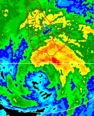
Radar out of New Orleans shows new towers going up in the S and SE eyewall. We are about to see dual hot towers again
0 likes   

User avatar
Stormybajan
Category 1
Category 1
Posts: 448
Joined: Thu May 20, 2021 3:21 pm
Location: Windward Islands

Re: ATL: IDA - Hurricane - Discussion

#2944 Postby Stormybajan » Sat Aug 28, 2021 9:53 pm

panamatropicwatch wrote:
SunnyThoughts wrote:Im hearing rumors that TEAL72 is in the air...can anyone confirm?

AF303 has taken off from San Antonio, Mission 12 into Ida. There goes my nap 8-)

Not sure how many times I've seen the words emergency recon thrown around :eek: but good on them for still attempting to get data from this Hurricane. Its badly needed.
2 likes   
Sad West Indies and Manchester United fan ⚽️

supercane4867
Category 5
Category 5
Posts: 4966
Joined: Wed Nov 14, 2012 10:43 am

Re: ATL: IDA - Hurricane - Discussion - RECON in route

#2945 Postby supercane4867 » Sat Aug 28, 2021 9:53 pm

A 25kt jump by 12hr forecast point. NHC must be really confident that Ida will reach CAT4

INIT 29/0300Z 27.2N 88.0W 90 KT 105 MPH
12H 29/1200Z 28.4N 89.4W 115 KT 130 MPH
1 likes   

Comradez
Tropical Low
Tropical Low
Posts: 32
Joined: Mon Aug 22, 2011 10:21 pm

Re: ATL: IDA - Hurricane - Discussion - RECON in route

#2946 Postby Comradez » Sat Aug 28, 2021 9:53 pm

No stadium effect yet with the eye. It probably needs that in order to reach cat 4. The CDO is also not fully symmetrical, although it has much better wrapping and cold cloud tops than before. Probably low 950s right now.
0 likes   

User avatar
Hypercane_Kyle
Category 5
Category 5
Posts: 3352
Joined: Sat Mar 07, 2015 7:58 pm
Location: Cape Canaveral, FL

Re: ATL: IDA - Hurricane - Discussion - RECON in route

#2947 Postby Hypercane_Kyle » Sat Aug 28, 2021 9:54 pm

Figured they might hold at 90 knots with a recon enroute. Ida has been playing "gotcha" with its sat presentation all day.
1 likes   
My posts are my own personal opinion, defer to the National Hurricane Center (NHC) and other NOAA products for decision making during hurricane season.

Fancy1001
Category 1
Category 1
Posts: 452
Joined: Thu Jul 16, 2020 10:16 pm

Re: ATL: IDA - Hurricane - Discussion - RECON in route

#2948 Postby Fancy1001 » Sat Aug 28, 2021 9:54 pm

supercane4867 wrote:A 25kt jump by 12hr forecast point. NHC must be really confident that Ida will reach CAT4

INIT 29/0300Z 27.2N 88.0W 90 KT 105 MPH
12H 29/1200Z 28.4N 89.4W 115 KT 130 MPH

She’s just taking her sweet little time getting there.
0 likes   

User avatar
Stormgodess
Category 1
Category 1
Posts: 301
Joined: Mon Sep 14, 2020 1:31 am

Re: ATL: IDA - Hurricane - Discussion - RECON in route

#2949 Postby Stormgodess » Sat Aug 28, 2021 9:54 pm

Hey guys. Hope all is safe or hunkered down that are in the path of this storm
Im having bad issues with my internet again. And cant get any maps to load. Can someone please let me konw about what time we'll be getting bands coming into around the I-12 corridor Between Baton Rouge and Hammond?
0 likes   

User avatar
galaxy401
Category 5
Category 5
Posts: 2419
Age: 30
Joined: Sat Aug 25, 2012 9:04 pm
Location: Casa Grande, Arizona

Re: ATL: IDA - Hurricane - Discussion - RECON in route

#2950 Postby galaxy401 » Sat Aug 28, 2021 9:55 pm

Glad to see the Recon plane back. Hopefully no incident happens. See if the pressure is still quickly dropping.

Also that track has it going very close to New Orleans. With its fast speed, it could still be very powerful when it gets there.
0 likes   
Got my eyes on moving right into Hurricane Alley: Florida.

bella_may
Category 4
Category 4
Posts: 908
Joined: Wed Dec 22, 2010 2:13 pm
Location: SE Mississippi coast

Re: ATL: IDA - Hurricane - Discussion - RECON in route

#2951 Postby bella_may » Sat Aug 28, 2021 9:55 pm

NOLA needs to prepare for a direct hit
1 likes   

Smurfwicked
Tropical Storm
Tropical Storm
Posts: 164
Age: 40
Joined: Mon Sep 03, 2007 7:47 pm
Location: SETX

Re: ATL: IDA - Hurricane - Discussion - RECON in route

#2952 Postby Smurfwicked » Sat Aug 28, 2021 9:56 pm

I haven't seen it mentioned here yet but according to this Ida will make landfall very close to the time of high tide.
https://www.tide-forecast.com/locations ... des/latest
0 likes   

User avatar
gatorcane
S2K Supporter
S2K Supporter
Posts: 23691
Age: 47
Joined: Sun Mar 13, 2005 3:54 pm
Location: Boca Raton, FL

Re: ATL: IDA - Hurricane - Discussion - RECON in route

#2953 Postby gatorcane » Sat Aug 28, 2021 9:57 pm

NHC stuck with recon data from an hour or two ago with an extrapolation of 2mb decrease an hour to arrive at 964MB. I do believe the winds are stronger than 105mph at this point but since recon is on the way, they decided to wait.
0 likes   

RL3AO
Moderator-Pro Met
Moderator-Pro Met
Posts: 16308
Joined: Thu Jun 14, 2007 10:03 pm
Location: NC

Re: ATL: IDA - Hurricane - Discussion - RECON in route

#2954 Postby RL3AO » Sat Aug 28, 2021 9:58 pm

Smurfwicked wrote:I haven't seen it mentioned here yet but according to this Ida will make landfall very close to the time of high tide.
https://www.tide-forecast.com/locations ... des/latest


The Gulf coast has extremely small tidal ranges, so it won't make much of an impact.
1 likes   

User avatar
Blown Away
S2K Supporter
S2K Supporter
Posts: 10146
Joined: Wed May 26, 2004 6:17 am

Re: ATL: IDA - Hurricane - Discussion - RECON in route

#2955 Postby Blown Away » Sat Aug 28, 2021 10:00 pm

bella_may wrote:NOLA needs to prepare for a direct hit


NOLA looks to be just on the edge of TS/H force winds after landfall. Hurricane force winds only 35 miles from center, so current track may keep NOLA just on the edge. Every slight adjustment E likely puts NOLA in H force winds.
0 likes   
Hurricane Eye Experience: David 79, Irene 99, Frances 04, Jeanne 04, Wilma 05... EYE COMING MY WAY IN 2024…
Hurricane Brush Experience: Andrew 92, Erin 95, Floyd 99, Matthew 16, Irma 17, Ian 22, Nicole 22…

User avatar
Hammy
Category 5
Category 5
Posts: 5849
Age: 41
Joined: Fri May 25, 2012 5:25 pm
Contact:

Re: ATL: IDA - Hurricane - Discussion - RECON in route

#2956 Postby Hammy » Sat Aug 28, 2021 10:00 pm

galaxy401 wrote:Glad to see the Recon plane back. Hopefully no incident happens. See if the pressure is still quickly dropping.

Also that track has it going very close to New Orleans. With its fast speed, it could still be very powerful when it gets there.


When's the plane expected to arrive?
0 likes   
The above post is not official and should not be used as such. It is the opinion of the poster and may or may not be backed by sound meteorological data. It is not endorsed by any professional institution or storm2k.org. For official information, please refer to the NHC and NWS products.

supercane4867
Category 5
Category 5
Posts: 4966
Joined: Wed Nov 14, 2012 10:43 am

Re: ATL: IDA - Hurricane - Discussion - RECON in route

#2957 Postby supercane4867 » Sat Aug 28, 2021 10:00 pm

New hot towers popping up in the eyewall
0 likes   

User avatar
jasons2k
Storm2k Executive
Storm2k Executive
Posts: 8245
Age: 51
Joined: Wed Jul 06, 2005 12:32 pm
Location: The Woodlands, TX

Re: ATL: IDA - Hurricane - Discussion - RECON in route

#2958 Postby jasons2k » Sat Aug 28, 2021 10:02 pm

Steve wrote:Slight East shift in the track

Told you Thu Night it was Grand Isle. Hope you are safe Steve.
3 likes   

tolakram
Admin
Admin
Posts: 20009
Age: 62
Joined: Sun Aug 27, 2006 8:23 pm
Location: Florence, KY (name is Mark)

Re: ATL: IDA - Hurricane - Discussion - RECON in route

#2959 Postby tolakram » Sat Aug 28, 2021 10:05 pm

000
WTNT44 KNHC 290250
TCDAT4

Hurricane Ida Discussion Number 11
NWS National Hurricane Center Miami FL AL092021
1000 PM CDT Sat Aug 28 2021

The NOAA Hurricane Hunters investigated Ida earlier this evening and
found that the maximum winds were still around 90 kt. Although the
peak winds appear to have leveled off for now, the minimum pressure
has continued to fall and was down to 966 mb at the last pass
through the center an hour or two ago. In fact, the pressure has
been dropping by about 2 mb per hour based on the aircraft data. In
addition, tail Doppler Radar data from the aircraft indicate that
the vortex has become more symmetric and that the inner core has
contracted from the mission earlier today. These are signals that
Ida is poised to strengthen further, and based on recent satellite
images it appears that strengthening is imminent. Flight-level and
SFMR observations also indicate that Ida's wind field has expanded
and there is some indication of a double-wind maximum. The
tropical-storm-force winds now extend outward up to 120 n mi from
the center and hurricane-force winds up to 35 n mi from the eye.

Ida continues to move steadily to the northwest at about 14 kt.
There has been little change to the track forecast rationale. A
subtropical ridge situated near the southeast U.S. coast is expected
to shift westward during the next day or two. This feature should
continue to steer Ida northwestward toward the Louisiana coast. The
latest runs of the numerical models bring the center of Ida to
southeast or south-central Louisiana Sunday afternoon. Although
landfall is not expected for about 18 hours, impacts will begin well
before that time. Tropical-storm-force winds are likely to begin
overnight, therefore, all preparations to protect life and property
must be rushed to completion. The new track forecast is just a
little to the east of the previous one through landfall. After Ida
moves inland, a turn to the north and then the northeast is expected
as the storm moves in the flow on the northwest and north sides of
the ridge.

Ida remains over waters with high oceanic heat content, and in an
atmospheric environment of low wind shear and abundant moisture.
These conditions, combined with the improved structure of the
hurricane, should allow Ida to rapidly intensify until it makes
landfall. The models remain in fairly good agreement, and the NHC
forecast holds steady and brings Ida to a dangerous major hurricane
prior to landfall. After the storm moves inland on Sunday, rapid
weakening is forecast due to a combination of land interaction,
drier air and some increase in wind shear.

Users are again reminded to not focus on the exact details of the
track forecast as storm surge, wind, and rainfall impacts will
extend far from the center. Rainfall impacts will also spread
inland across the Lower Mississippi and Tennessee Valleys through
early next week.

Key Messages:

1. There is a danger of life-threatening storm surge inundation
Sunday along the coasts of Louisiana, Mississippi, and Alabama
within the Storm Surge Warning area. Extremely life-threatening
inundation of 9 feet or greater above ground level is possible
somewhere within the area from Morgan City, Louisiana, to the coast
of Mississippi. Overtopping of local levees outside of the Hurricane
and Storm Damage Risk Reduction System is possible where local
inundation values may be higher. Interests throughout the warning
area should follow any advice given by local officials.

2. Ida is expected to be an extremely dangerous major hurricane when
it reaches the coast of Louisiana. Hurricane-force winds are
expected Sunday in portions of the Hurricane Warning area along the
Louisiana coast, including metropolitan New Orleans, with
potentially catastrophic wind damage possible where the core of Ida
moves onshore. Actions to protect life and property should be rushed
to completion in the warning area.

3. Damaging winds, especially in gusts, will spread inland near the
track of the center of Ida across portions of southeastern Louisiana
and southwestern Mississippi Sunday night and early Monday. These
winds will likely lead to widespread tree damage and power outages.

4. Ida is likely to produce heavy rainfall Sunday into Monday across
the central Gulf Coast from southeast Louisiana, coastal
Mississippi, and far southwestern Alabama, resulting in considerable
to life-threatening flash and urban flooding and significant river
flooding impacts. As Ida moves inland, significant flooding impacts
are possible across portions of the Lower Mississippi, Tennessee,
and Ohio Valleys through Wednesday.


FORECAST POSITIONS AND MAX WINDS

INIT 29/0300Z 27.2N 88.0W 90 KT 105 MPH
12H 29/1200Z 28.4N 89.4W 115 KT 130 MPH
24H 30/0000Z 29.9N 90.7W 85 KT 100 MPH...INLAND
36H 30/1200Z 31.4N 91.2W 45 KT 50 MPH...INLAND
48H 31/0000Z 33.1N 90.6W 30 KT 35 MPH...INLAND
60H 31/1200Z 34.8N 89.1W 25 KT 30 MPH...INLAND
72H 01/0000Z 36.3N 86.7W 20 KT 25 MPH...INLAND
96H 02/0000Z 38.6N 80.6W 20 KT 25 MPH...POST-TROP/INLAND
120H 03/0000Z...DISSIPATED

$$
Forecaster Cangialosi
0 likes   
M a r k
- - - - -
Join us in chat: Storm2K Chatroom Invite. Android and IOS apps also available.

The posts in this forum are NOT official forecasts and should not be used as such. Posts are NOT endorsed by any professional institution or STORM2K.org. For official information and forecasts, please refer to NHC and NWS products.

supercane4867
Category 5
Category 5
Posts: 4966
Joined: Wed Nov 14, 2012 10:43 am

Re: ATL: IDA - Hurricane - Discussion - RECON in route

#2960 Postby supercane4867 » Sat Aug 28, 2021 10:07 pm

Should see stadium effect by sunrise

Image
7 likes   


Return to “2021”

Who is online

Users browsing this forum: No registered users and 15 guests