BULLETIN
Hurricane Nora Advisory Number 13
NWS National Hurricane Center Miami FL EP142021
400 PM CDT Sat Aug 28 2021
...NORA'S CENTER GRAZING THE COAST OF JALISCO MEXICO...
...HURRICANE WARNINGS EXTENDED NORTHWARD ALONG THE NAYARIT AND
SINALOA COASTS...
SUMMARY OF 400 PM CDT...2100 UTC...INFORMATION
----------------------------------------------
LOCATION...19.7N 105.4W
ABOUT 65 MI...100 KM SSW OF PUERTO VALLARTA MEXICO
ABOUT 365 MI...585 KM SE OF CABO SAN LUCAS MEXICO
MAXIMUM SUSTAINED WINDS...85 MPH...140 KM/H
PRESENT MOVEMENT...N OR 350 DEGREES AT 14 MPH...22 KM/H
MINIMUM CENTRAL PRESSURE...977 MB...28.85 INCHES
WATCHES AND WARNINGS
--------------------
CHANGES WITH THIS ADVISORY:
The government of Mexico has upgraded the Tropical Storm Warning
and Hurricane Watch north of San Blas to Altata, Mexico, to a
Hurricane Warning.
SUMMARY OF WATCHES AND WARNINGS IN EFFECT:
A Hurricane Warning is in effect for...
* Manzanillo to Altata Mexico
A Hurricane Watch is in effect for...
* North of Altata to Topolobampo Mexico
A Tropical Storm Warning is in effect for...
* South of Manzanillo to Lazaro Cardenas Mexico
A Tropical Storm Watch is in effect for...
* Cabo San Lucas to La Paz Mexico
A Hurricane Warning means that hurricane conditions are expected
somewhere within the warning area. A warning is typically issued
36 hours before the anticipated first occurrence of
tropical-storm-force winds, conditions that make outside
preparations difficult or dangerous. Preparations to protect life
and property should be rushed to completion.
A Hurricane Watch means that hurricane conditions are possible
within the watch area. A watch is typically issued 48 hours
before the anticipated first occurrence of tropical-storm-force
winds, conditions that make outside preparations difficult or
dangerous.
A Tropical Storm Warning means that tropical storm conditions are
expected somewhere within the warning area within 36 hours.
A Tropical Storm Watch means that tropical storm conditions are
possible within the watch area, generally within 48 hours.
Interests elsewhere along the coasts of Sinaloa, Sonora, and Baja
California Sur should monitor the progress of Nora. Additional
watches and warnings may be required for portions of these areas
tonight or on Sunday.
For storm information specific to your area, please monitor
products issued by your national meteorological service.
DISCUSSION AND OUTLOOK
----------------------
At 400 PM CDT (2100 UTC), the center of Hurricane Nora was located
near latitude 19.7 North, longitude 105.4 West. Nora is moving
toward the north near 14 mph (22 km/h). A turn toward the
north-northwest is expected tonight and on Sunday, followed by a
slower northwestward motion Sunday night through Tuesday. On the
forecast track, the center of Nora will move near or over western
Jalisco during the next few hours, and then move over the Gulf
of California near or along the coasts of Nayarit and Sinaloa
tonight through Tuesday.
Maximum sustained winds are near 85 mph (140 km/h) with higher
gusts. Little change in strength is forecast during the next few
days if Nora's center remains over the waters of the Gulf of
California. However, weakening would likely occur if the center
moves inland.
Hurricane-force winds extend outward up to 35 miles (55 km) from the
center and tropical-storm-force winds extend outward up to 160 miles
(260 km). A sustained wind of 77 mph (124 km/h) was recently
reported at Chamela-Cuixmala, Jalisco.
The estimated minimum central pressure is 977 mb (28.85 inches).
HAZARDS AFFECTING LAND
----------------------
Key messages for Nora can be found in the Tropical Cyclone
Discussion under AWIPS header MIATCDEP4, WMO header WTPZ44 KNHC,
and on the web at hurricanes.gov/graphics_ep4.shtml?key_messages.
WIND: Hurricane conditions are occurring within the southern
portion of the hurricane warning area and are likely to spread
northward within hurricane warning area through Monday. Hurricane
conditions are also possible within the hurricane watch area late
Monday. Tropical storm conditions will continue over the tropical
storm warning area through tonight. Tropical storm conditions are
possible within the tropical storm watch area in Baja California
Sur on Monday.
RAINFALL: Nora is expected to produce rainfall totals of 8 to 12
inches with maximum amounts of 20 inches this weekend into early
next week along the west coast of Mexico from the Mexican states of
Guerrero northward to southern Sonora, including Baja California
Sur. This rainfall will produce life-threatening flash flooding and
mudslides.
Toward the middle and latter part of next week, moisture associated
with Nora may bring heavy rainfall to portions of the southwestern
U.S. and central Rockies.
STORM SURGE: Storm surge is expected to produce significant
coastal flooding in areas of onshore winds. Near the coast, the
surge will be accompanied by large and destructive waves.
SURF: Swells generated by Nora are affecting the southern and
southwestern coast of Mexico and will spread northward to the coast
of Baja California Sur and into the Gulf of California into early
next week. These swells are likely to cause life-threatening surf
and rip current conditions. Please consult products from your
local weather office.
NEXT ADVISORY
-------------
Next intermediate advisory at 700 PM CDT.
Next complete advisory at 1000 PM CDT.
$$
Forecaster Berg
Hurricane Nora Discussion Number 13
NWS National Hurricane Center Miami FL EP142021
400 PM CDT Sat Aug 28 2021
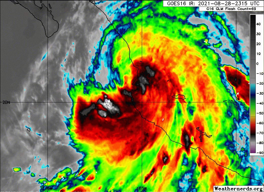
Nora developed a cloud-filled eye during the past few hours, with
the center now grazing the coast and the eyewall moving across
western Jalisco, Mexico. An Air Force Reserve Hurricane Hunter
aircraft has been investigating the hurricane, but unfortunately
the storm is now too close to the mountainous coastline for the
plane to safely locate the surface center or sample the
likely-stronger wind field on the eastern side of the circulation.
Based mainly on T4.5/77 kt Dvorak estimates from TAFB and SAB, the
initial intensity is estimated to be 75 kt.
The center has been moving a little faster to the west of due
north, or 350/12 kt. The track models are in agreement that Nora
should turn toward the north-northwest and northwest during the next
few days, generally keeping the center of the hurricane over the
waters of the Gulf of California. However, due to the complex
geography and mountainous topography of the region, the track
forecast is challenging, and it's almost impossible to know if
Nora's center will remain over water or graze the coastlines of
Nayarit and Sinaloa over the next few days. By days 4 and 5, Nora's
center is forecast to move inland over Sonora after traversing a
significant length of the Gulf of California.
Assuming a path that keeps Nora just offshore, low shear and very
warm sea surface temperatures in the Gulf of California should be
sufficient to at least maintain hurricane intensity for the next 3
days. However, any slight deviations of the track could cause Nora
to weaken and fall below hurricane intensity sooner than is
indicated in the official forecast. Given the uncertainties,
however, the government of Mexico has extended the hurricane
warning farther north along the coasts of Nayarit and Sinaloa out
of an abundance of caution. Weakening will become more likely the
farther north Nora gets up the Gulf of California, both due to
possible land interaction and ingestion of drier air off the Mexican
plateau.
Key Messages:
1. Nora is forecast to be a hurricane while it moves near or
along the coasts of the Mexican states of Jalisco, Nayarit, and
Sinaloa through Monday, and hurricane warnings are in effect for
portions of that coastline. Interests in these areas should closely
monitor the progress of Nora and subsequent updates to the forecast.
2. Heavy rain associated with Nora is expected across the west coast
of Mexico from the Mexican states of Guerrero, northward to southern
Sonora, including Baja California Sur. This rain will likely
result in life-threatening flash flooding and mudslides across these
regions. Rainfall from Nora may spread into the southwestern U.S.
and central Rockies during the middle to latter portion of next
week.
3. Nora is forecast to continue moving northward over the Gulf of
California Tuesday and Wednesday, bringing a risk of wind impacts to
portions of the Mexican states of Baja California Sur, northern
Sinaloa, and Sonora. Given the above-average uncertainty in the
forecast intensity, confidence is not high enough to determine the
magnitude and location of these potential impacts.
FORECAST POSITIONS AND MAX WINDS
INIT 28/2100Z 19.7N 105.4W 75 KT 85 MPH...ON THE COAST
12H 29/0600Z 21.5N 105.9W 75 KT 85 MPH
24H 29/1800Z 22.9N 106.7W 75 KT 85 MPH
36H 30/0600Z 23.5N 107.4W 75 KT 85 MPH
48H 30/1800Z 24.2N 108.1W 75 KT 85 MPH
60H 31/0600Z 24.8N 108.9W 70 KT 80 MPH
72H 31/1800Z 25.6N 109.5W 70 KT 80 MPH
96H 01/1800Z 27.6N 110.4W 55 KT 65 MPH...INLAND
120H 02/1800Z 29.4N 110.6W 30 KT 35 MPH...INLAND
$$
Forecaster Berg
Hurricane Nora Advisory Number 13
NWS National Hurricane Center Miami FL EP142021
400 PM CDT Sat Aug 28 2021
...NORA'S CENTER GRAZING THE COAST OF JALISCO MEXICO...
...HURRICANE WARNINGS EXTENDED NORTHWARD ALONG THE NAYARIT AND
SINALOA COASTS...
SUMMARY OF 400 PM CDT...2100 UTC...INFORMATION
----------------------------------------------
LOCATION...19.7N 105.4W
ABOUT 65 MI...100 KM SSW OF PUERTO VALLARTA MEXICO
ABOUT 365 MI...585 KM SE OF CABO SAN LUCAS MEXICO
MAXIMUM SUSTAINED WINDS...85 MPH...140 KM/H
PRESENT MOVEMENT...N OR 350 DEGREES AT 14 MPH...22 KM/H
MINIMUM CENTRAL PRESSURE...977 MB...28.85 INCHES
WATCHES AND WARNINGS
--------------------
CHANGES WITH THIS ADVISORY:
The government of Mexico has upgraded the Tropical Storm Warning
and Hurricane Watch north of San Blas to Altata, Mexico, to a
Hurricane Warning.
SUMMARY OF WATCHES AND WARNINGS IN EFFECT:
A Hurricane Warning is in effect for...
* Manzanillo to Altata Mexico
A Hurricane Watch is in effect for...
* North of Altata to Topolobampo Mexico
A Tropical Storm Warning is in effect for...
* South of Manzanillo to Lazaro Cardenas Mexico
A Tropical Storm Watch is in effect for...
* Cabo San Lucas to La Paz Mexico
A Hurricane Warning means that hurricane conditions are expected
somewhere within the warning area. A warning is typically issued
36 hours before the anticipated first occurrence of
tropical-storm-force winds, conditions that make outside
preparations difficult or dangerous. Preparations to protect life
and property should be rushed to completion.
A Hurricane Watch means that hurricane conditions are possible
within the watch area. A watch is typically issued 48 hours
before the anticipated first occurrence of tropical-storm-force
winds, conditions that make outside preparations difficult or
dangerous.
A Tropical Storm Warning means that tropical storm conditions are
expected somewhere within the warning area within 36 hours.
A Tropical Storm Watch means that tropical storm conditions are
possible within the watch area, generally within 48 hours.
Interests elsewhere along the coasts of Sinaloa, Sonora, and Baja
California Sur should monitor the progress of Nora. Additional
watches and warnings may be required for portions of these areas
tonight or on Sunday.
For storm information specific to your area, please monitor
products issued by your national meteorological service.
DISCUSSION AND OUTLOOK
----------------------
At 400 PM CDT (2100 UTC), the center of Hurricane Nora was located
near latitude 19.7 North, longitude 105.4 West. Nora is moving
toward the north near 14 mph (22 km/h). A turn toward the
north-northwest is expected tonight and on Sunday, followed by a
slower northwestward motion Sunday night through Tuesday. On the
forecast track, the center of Nora will move near or over western
Jalisco during the next few hours, and then move over the Gulf
of California near or along the coasts of Nayarit and Sinaloa
tonight through Tuesday.
Maximum sustained winds are near 85 mph (140 km/h) with higher
gusts. Little change in strength is forecast during the next few
days if Nora's center remains over the waters of the Gulf of
California. However, weakening would likely occur if the center
moves inland.
Hurricane-force winds extend outward up to 35 miles (55 km) from the
center and tropical-storm-force winds extend outward up to 160 miles
(260 km). A sustained wind of 77 mph (124 km/h) was recently
reported at Chamela-Cuixmala, Jalisco.
The estimated minimum central pressure is 977 mb (28.85 inches).
HAZARDS AFFECTING LAND
----------------------
Key messages for Nora can be found in the Tropical Cyclone
Discussion under AWIPS header MIATCDEP4, WMO header WTPZ44 KNHC,
and on the web at hurricanes.gov/graphics_ep4.shtml?key_messages.
WIND: Hurricane conditions are occurring within the southern
portion of the hurricane warning area and are likely to spread
northward within hurricane warning area through Monday. Hurricane
conditions are also possible within the hurricane watch area late
Monday. Tropical storm conditions will continue over the tropical
storm warning area through tonight. Tropical storm conditions are
possible within the tropical storm watch area in Baja California
Sur on Monday.
RAINFALL: Nora is expected to produce rainfall totals of 8 to 12
inches with maximum amounts of 20 inches this weekend into early
next week along the west coast of Mexico from the Mexican states of
Guerrero northward to southern Sonora, including Baja California
Sur. This rainfall will produce life-threatening flash flooding and
mudslides.
Toward the middle and latter part of next week, moisture associated
with Nora may bring heavy rainfall to portions of the southwestern
U.S. and central Rockies.
STORM SURGE: Storm surge is expected to produce significant
coastal flooding in areas of onshore winds. Near the coast, the
surge will be accompanied by large and destructive waves.
SURF: Swells generated by Nora are affecting the southern and
southwestern coast of Mexico and will spread northward to the coast
of Baja California Sur and into the Gulf of California into early
next week. These swells are likely to cause life-threatening surf
and rip current conditions. Please consult products from your
local weather office.
NEXT ADVISORY
-------------
Next intermediate advisory at 700 PM CDT.
Next complete advisory at 1000 PM CDT.
$$
Forecaster Berg
Hurricane Nora Discussion Number 13
NWS National Hurricane Center Miami FL EP142021
400 PM CDT Sat Aug 28 2021
Nora developed a cloud-filled eye during the past few hours, with
the center now grazing the coast and the eyewall moving across
western Jalisco, Mexico. An Air Force Reserve Hurricane Hunter
aircraft has been investigating the hurricane, but unfortunately
the storm is now too close to the mountainous coastline for the
plane to safely locate the surface center or sample the
likely-stronger wind field on the eastern side of the circulation.
Based mainly on T4.5/77 kt Dvorak estimates from TAFB and SAB, the
initial intensity is estimated to be 75 kt.
The center has been moving a little faster to the west of due
north, or 350/12 kt. The track models are in agreement that Nora
should turn toward the north-northwest and northwest during the next
few days, generally keeping the center of the hurricane over the
waters of the Gulf of California. However, due to the complex
geography and mountainous topography of the region, the track
forecast is challenging, and it's almost impossible to know if
Nora's center will remain over water or graze the coastlines of
Nayarit and Sinaloa over the next few days. By days 4 and 5, Nora's
center is forecast to move inland over Sonora after traversing a
significant length of the Gulf of California.
Assuming a path that keeps Nora just offshore, low shear and very
warm sea surface temperatures in the Gulf of California should be
sufficient to at least maintain hurricane intensity for the next 3
days. However, any slight deviations of the track could cause Nora
to weaken and fall below hurricane intensity sooner than is
indicated in the official forecast. Given the uncertainties,
however, the government of Mexico has extended the hurricane
warning farther north along the coasts of Nayarit and Sinaloa out
of an abundance of caution. Weakening will become more likely the
farther north Nora gets up the Gulf of California, both due to
possible land interaction and ingestion of drier air off the Mexican
plateau.
Key Messages:
1. Nora is forecast to be a hurricane while it moves near or
along the coasts of the Mexican states of Jalisco, Nayarit, and
Sinaloa through Monday, and hurricane warnings are in effect for
portions of that coastline. Interests in these areas should closely
monitor the progress of Nora and subsequent updates to the forecast.
2. Heavy rain associated with Nora is expected across the west coast
of Mexico from the Mexican states of Guerrero, northward to southern
Sonora, including Baja California Sur. This rain will likely
result in life-threatening flash flooding and mudslides across these
regions. Rainfall from Nora may spread into the southwestern U.S.
and central Rockies during the middle to latter portion of next
week.
3. Nora is forecast to continue moving northward over the Gulf of
California Tuesday and Wednesday, bringing a risk of wind impacts to
portions of the Mexican states of Baja California Sur, northern
Sinaloa, and Sonora. Given the above-average uncertainty in the
forecast intensity, confidence is not high enough to determine the
magnitude and location of these potential impacts.
FORECAST POSITIONS AND MAX WINDS
INIT 28/2100Z 19.7N 105.4W 75 KT 85 MPH...ON THE COAST
12H 29/0600Z 21.5N 105.9W 75 KT 85 MPH
24H 29/1800Z 22.9N 106.7W 75 KT 85 MPH
36H 30/0600Z 23.5N 107.4W 75 KT 85 MPH
48H 30/1800Z 24.2N 108.1W 75 KT 85 MPH
60H 31/0600Z 24.8N 108.9W 70 KT 80 MPH
72H 31/1800Z 25.6N 109.5W 70 KT 80 MPH
96H 01/1800Z 27.6N 110.4W 55 KT 65 MPH...INLAND
120H 02/1800Z 29.4N 110.6W 30 KT 35 MPH...INLAND
$$
Forecaster Berg