ATL: IDA - Remnants - Discussion

Moderator: S2k Moderators

Message
Author
supercane4867
Category 5
Category 5
Posts: 4966
Joined: Wed Nov 14, 2012 10:43 am

Re: ATL: IDA - Hurricane - Discussion

#3341 Postby supercane4867 » Sun Aug 29, 2021 1:51 am

Ida's central pressure has fallen 6 millibars during the past hour.

Even Stewart is shocked at the rate of deepening lol
8 likes   

User avatar
ElectricStorm
Category 5
Category 5
Posts: 5048
Age: 24
Joined: Tue Aug 13, 2019 11:23 pm
Location: Skiatook, OK / Norman, OK

Re: ATL: IDA - Hurricane - Discussion

#3342 Postby ElectricStorm » Sun Aug 29, 2021 1:52 am

Raw T's up to 6.8 :eek:
0 likes   
B.S Meteorology, University of Oklahoma '25

Please refer to the NHC, NWS, or SPC for official information.

User avatar
skyline385
Category 5
Category 5
Posts: 2728
Age: 35
Joined: Wed Aug 26, 2020 11:15 pm
Location: Houston TX

Re: ATL: IDA - Hurricane - Discussion

#3343 Postby skyline385 » Sun Aug 29, 2021 1:52 am

skyline385 wrote:
wx98 wrote:
Highteeld wrote:With the 133 kt FL winds, the 115 SFMR, despite being flagged, is probably correct.


I was thinking that as well.


The NHC might decide that its correct looking at the FL winds, lets see what their update brings.


NHC actually went with 115 kt SFMR for the update...
0 likes   

TallahasseeMan
Tropical Storm
Tropical Storm
Posts: 120
Joined: Sat Aug 01, 2020 1:49 pm

Re: ATL: IDA - Hurricane - Discussion

#3344 Postby TallahasseeMan » Sun Aug 29, 2021 1:53 am

Going by NHC advisories, Ida made the jump from CAT 3 to Cat 4 in about an hour...
3 likes   
Direct hit: Francis '04, Jeanne '04, Wilma '05 Hermine '16 Michael '18

Outer bands: Katrina '05 Irma '17

Dean4Storms
S2K Supporter
S2K Supporter
Posts: 6358
Age: 62
Joined: Sun Aug 31, 2003 1:01 pm
Location: Miramar Bch. FL

Re: ATL: IDA - Hurricane - Discussion

#3345 Postby Dean4Storms » Sun Aug 29, 2021 1:53 am

Getting that buzz saw look.
1 likes   

User avatar
kevin
Category 5
Category 5
Posts: 2586
Age: 26
Joined: Wed Aug 28, 2019 4:35 am

Re: ATL: IDA - Hurricane - Discussion

#3346 Postby kevin » Sun Aug 29, 2021 1:53 am

Raw Ts up to 6.8, if that holds for CI later today that would mean ADT thinks 135kt is definitely on the table.
0 likes   

Comradez
Tropical Low
Tropical Low
Posts: 32
Joined: Mon Aug 22, 2011 10:21 pm

Re: ATL: IDA - Hurricane - Discussion

#3347 Postby Comradez » Sun Aug 29, 2021 1:54 am

What's weird is, the eye is looking a little ragged, and yet the cold convection around the eyewall is looking more vicious than ever. Could that just be some overshooting cloudtops from the eyewall obscuring the true eye on infrared satellite?
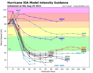
1 likes   

KyleEverett
Tropical Low
Tropical Low
Posts: 39
Joined: Sun Jun 27, 2010 9:13 pm

Re: ATL: IDA - Hurricane - Discussion

#3348 Postby KyleEverett » Sun Aug 29, 2021 1:55 am

Comradez wrote:What's weird is, the eye is looking a little ragged, and yet the cold convection around the eyewall is looking more vicious than ever. Could that just be some overshooting cloudtops from the eyewall obscuring the true eye on infrared satellite?


Indeed. You'll often see that with intensifying hurricanes.
5 likes   

LARanger
Tropical Storm
Tropical Storm
Posts: 131
Joined: Wed Oct 07, 2020 12:45 pm

Re: ATL: IDA - Hurricane - Discussion

#3349 Postby LARanger » Sun Aug 29, 2021 1:55 am

If she keeps this up I am going to reconsider my location. I may be a fair bit inland but the NHC line is drawn onto my roof.

As for aging like fine milk, at least folks were in august company. The NHC kept it at 4 despite the models.

Image
Last edited by LARanger on Sun Aug 29, 2021 1:57 am, edited 1 time in total.
8 likes   
Baton Rouge area cyclone dilettante, PSWAGGER* tropical weather & hydrology model developer
(* Pseudo-Scientific Wild-A** Guesses Generally Expressed Ridiculously)
The GFDL would've had all this figured out by now.

User avatar
Teban54
Category 5
Category 5
Posts: 3207
Joined: Sat May 19, 2018 1:19 pm

Re: ATL: IDA - Hurricane - Discussion

#3350 Postby Teban54 » Sun Aug 29, 2021 1:56 am

Comradez wrote:What's weird is, the eye is looking a little ragged, and yet the cold convection around the eyewall is looking more vicious than ever. Could that just be some overshooting cloudtops from the eyewall obscuring the true eye on infrared satellite?

To my amateur eyes, the eye seems slightly tilted and is being rotated to the NE now.
0 likes   

caneseddy
Category 5
Category 5
Posts: 1172
Joined: Fri Sep 03, 2004 9:31 pm
Location: Plantation, FL

Re: ATL: IDA - Hurricane - Discussion

#3351 Postby caneseddy » Sun Aug 29, 2021 1:56 am

Hopefully everyone has evacuated from Grand Isle, Port Fouchon, Golden Meadow, Galliano, and Cut Off. I shudder how those areas will look like after this passes..
Last edited by caneseddy on Sun Aug 29, 2021 1:57 am, edited 1 time in total.
0 likes   

fendie
S2K Supporter
S2K Supporter
Posts: 151
Joined: Sun Aug 26, 2012 10:33 am
Location: Austin, TX

Re: ATL: IDA - Hurricane - Discussion

#3352 Postby fendie » Sun Aug 29, 2021 1:57 am

Saved radar loop

Image
0 likes   

User avatar
drezee
S2K Supporter
S2K Supporter
Posts: 3664
Joined: Mon Jun 09, 2003 12:49 pm
Location: FL

Re: ATL: IDA - Hurricane - Discussion

#3353 Postby drezee » Sun Aug 29, 2021 1:57 am

1 likes   

drewschmaltz
S2K Supporter
S2K Supporter
Posts: 350
Joined: Thu Aug 27, 2015 8:19 pm

Re: ATL: IDA - Hurricane - Discussion

#3354 Postby drewschmaltz » Sun Aug 29, 2021 1:58 am

Anyone familiar with LA? Forecasted landfall vs Katrina. How is it potentially different (for better or worse)?
0 likes   
I HAVE ABSOLUTELY NO IDEA WHAT I'M TALKING ABOUT. PLEASE CONSULT SOMEONE WHO DOES. START WITH THE NHC. ALL POSTS ARE FOR ENTERTAINMENT PURPOSES ONLY.

wx98
Category 5
Category 5
Posts: 1383
Joined: Sat Aug 25, 2018 9:24 pm

Re: ATL: IDA - Hurricane - Discussion

#3355 Postby wx98 » Sun Aug 29, 2021 1:58 am

skyline385 wrote:
skyline385 wrote:
wx98 wrote:
I was thinking that as well.


The NHC might decide that its correct looking at the FL winds, lets see what their update brings.


NHC actually went with 115 kt SFMR for the update...


At this rate, it was probably necessary to keep up with the intensification rate while waiting for the next plane.
0 likes   

USTropics
Professional-Met
Professional-Met
Posts: 2653
Joined: Sun Aug 12, 2007 3:45 am
Location: Florida State University

Re: ATL: IDA - Hurricane - Discussion

#3356 Postby USTropics » Sun Aug 29, 2021 1:59 am

Comradez wrote:What's weird is, the eye is looking a little ragged, and yet the cold convection around the eyewall is looking more vicious than ever. Could that just be some overshooting cloudtops from the eyewall obscuring the true eye on infrared satellite?
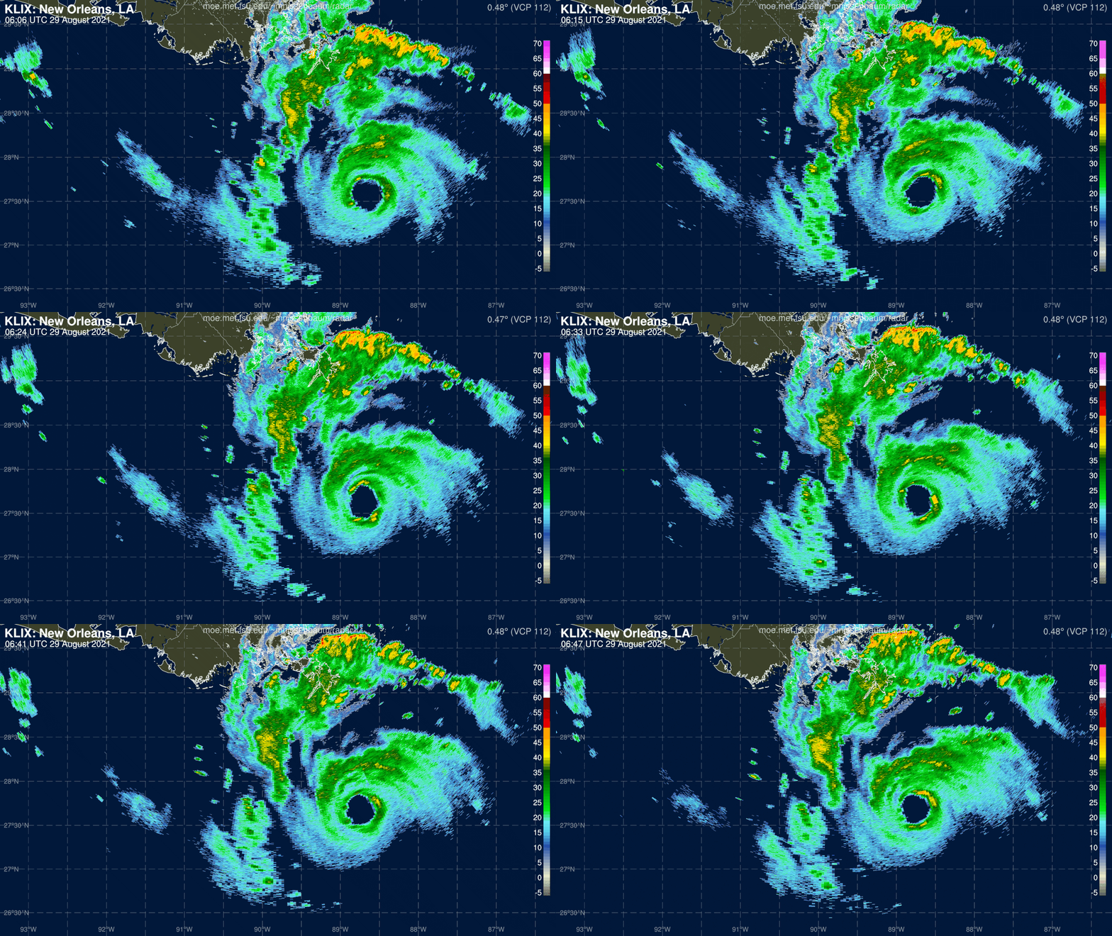

There are multiple mesovortices rotating within the eyewall's diameter (common feature for intense tropical systems), which creates the illusion the center is ragged or elongated. This is far from the case though, and if we look underneath the upper-levels (i.e., using radar imagery) we can see these mesovortices features. Impressive, even with radar attenuation.

Image
10 likes   

wx98
Category 5
Category 5
Posts: 1383
Joined: Sat Aug 25, 2018 9:24 pm

Re: ATL: IDA - Hurricane - Discussion

#3357 Postby wx98 » Sun Aug 29, 2021 1:59 am

TallahasseeMan wrote:Going by NHC advisories, Ida made the jump from CAT 3 to Cat 4 in about an hour...

Isn’t this like a Charley-level explosion?
1 likes   

User avatar
Hurrilurker
Category 2
Category 2
Posts: 719
Joined: Mon Jun 09, 2003 3:32 pm
Location: San Francisco, CA

Re: ATL: IDA - Hurricane - Discussion

#3358 Postby Hurrilurker » Sun Aug 29, 2021 1:59 am

When's the next recon? Right now if it's 3 hours, they're going to miss a lot.
0 likes   

User avatar
Stormgodess
Category 1
Category 1
Posts: 301
Joined: Mon Sep 14, 2020 1:31 am

Re: ATL: IDA - Hurricane - Discussion

#3359 Postby Stormgodess » Sun Aug 29, 2021 2:00 am

HDGator wrote:
Stormgodess wrote:
Teban54 wrote:Note that water near the coast has lower OHC despite higher surface temperatures. Likely won't be too much of an issue for the fast-moving Ida, but when it struggled to RI earlier in the day, some people pointed to the low OHC (despite high SSTs) as one possible cause.


How fast is she moving, its something I keep meaning to check on, but with prepping , and LITERALLY I slipped off a wet ladder today and got hit in the head by a 2x4... I keep forgetting to check! :double: :D

She's moving NW at 15mph per the 1 am CDT NHC update.
The NHC forecast has her slowing down as the center gets closer to you (not a good thing, I know).
I've had the radar on screen with the NHC forecast tracks and she just hit her forecast point for 06z almost dead on from the 5pm forecast yesterday.

If I were you, I'd focus on the NHC forecast and also look at your local NWS forecast discussions for more details on your area.

As a lifelong resident of South FL (until last year), I've been through the stress too many times to count. You're ahead of the game on preps and knowledge; get some rest before tomorrow.


Yall really need a hug emoji... I'm a hugger.

Thank you. Thank you all actually. *hugs*
6 likes   

User avatar
kevin
Category 5
Category 5
Posts: 2586
Age: 26
Joined: Wed Aug 28, 2019 4:35 am

Re: ATL: IDA - Hurricane - Discussion

#3360 Postby kevin » Sun Aug 29, 2021 2:01 am

drewschmaltz wrote:Anyone familiar with LA? Forecasted landfall vs Katrina. How is it potentially different (for better or worse)?


Due to the long time that Katrina sustained MH winds its storm surge was pretty much unparalleled with anything else in the history of the Atlantic so it's near-impossible for any other storm to reach those values. However, don't get me wrong when the only storm you can somewhat compare values to is Katrina then you know that something bad is gonna happen. Many areas along the coast will probably see 10 - 15 ft surge. This will probably have stronger LF winds than Katrina.
3 likes   


Return to “2021”

Who is online

Users browsing this forum: No registered users and 2 guests