https://twitter.com/Randy_SELAwxwrn/status/1431916365921898499
ATL: IDA - Remnants - Discussion
Moderator: S2k Moderators
-
Shell Mound
- Category 5

- Posts: 2432
- Age: 33
- Joined: Thu Sep 07, 2017 3:39 pm
- Location: St. Petersburg, FL → Scandinavia
Re: ATL: IDA - Hurricane - Discussion
2 likes
CVW / MiamiensisWx / Shell Mound
The posts in this forum are NOT official forecasts and should not be used as such. They are just the opinion of the poster and may or may not be backed by sound meteorological data. They are NOT endorsed by any professional institution or STORM2K. For official information, please refer to products from the NHC and NWS.

Re: ATL: IDA - Hurricane - Discussion
That has to be one of the most ominous hurricane pictures I've seen.
0 likes
-
Chris_in_Tampa
- Category 5
- Posts: 5101
- Age: 42
- Joined: Thu Jun 21, 2007 11:06 pm
- Location: Tampa, Florida, USA
- Contact:
Re: ATL: IDA - Hurricane - Discussion
Deleted post about extrapolated sonde pressure because it is likely a bad sonde.
Last edited by Chris_in_Tampa on Sun Aug 29, 2021 4:56 am, edited 3 times in total.
0 likes

Re: ATL: IDA - Hurricane - Discussion
This is the time every wobble takes on exaggerated meaning. I've been safely west for a while now, but any drift West is disconcerting to me while any drift East is disconcerting to New Orleans. Could you pick a worse possible time (overnight) for Extra Rapid Intensification? There really is no time to evacuate safely if you haven't already done it or are a night owl. NO-ONE wants to be caught out in a traffic jam in the middle of a major hurricane.
0 likes
Living at the intersection of Rita and Humberto and Ike and Harvey and Laura and Delta!
This post is NOT an official forecast and should not be used as such. It is just my opinion and may or may not be backed by sound meteorological products.
This post is NOT an official forecast and should not be used as such. It is just my opinion and may or may not be backed by sound meteorological products.
-
KBBOCA
- S2K Supporter

- Posts: 1559
- Joined: Fri Sep 05, 2003 5:27 am
- Location: Formerly Boca Raton, often West Africa. Currently Charlotte NC
Re: ATL: IDA - Hurricane - Discussion
Catching up on twitter after a brief nap... saw this. Apologies if already posted.
https://twitter.com/CraigSetzer/status/1431872350732042246
https://twitter.com/CraigSetzer/status/1431872350732042246
1 likes
Re: ATL: IDA - Hurricane - Discussion
NOAA3 found hurricane level FL winds (so 72+ kt with a 0.9 reduction factor) up to 80 miles away from the center in the NE quadrant.
Last edited by kevin on Sun Aug 29, 2021 4:56 am, edited 1 time in total.
2 likes
-
dexterlabio
- Category 5
- Posts: 3509
- Joined: Sat Oct 24, 2009 11:50 pm
Re: ATL: IDA - Hurricane - Discussion
Im getting a vibe that there would be no more recon flight when Ida has cleared the eye. 4 to 6 hours before landfall, I think there is still ample time left for a fully clear eye.
0 likes
Personal Forecast Disclaimer:
The posts in this forum are NOT official forecast and should not be used as such. They are just the opinion of the poster and may or may not be backed by sound meteorological data. They are NOT endorsed by any professional institution or storm2k.org. For official information, please refer to the NHC and NWS products.
The posts in this forum are NOT official forecast and should not be used as such. They are just the opinion of the poster and may or may not be backed by sound meteorological data. They are NOT endorsed by any professional institution or storm2k.org. For official information, please refer to the NHC and NWS products.


Re: ATL: IDA - Hurricane - Discussion
145 mph per nhc
0 likes
Very useful information on the Dvorak Technique --
https://severe.worldweather.wmo.int/TCF ... kBeven.pdf
https://severe.worldweather.wmo.int/TCF ... kBeven.pdf
-
Texashawk

- Category 2

- Posts: 579
- Joined: Tue Aug 14, 2007 1:50 am
- Location: Missouri City, TX (Houston)
Re: ATL: IDA - Hurricane - Discussion
Shell Mound wrote:https://twitter.com/Randy_SELAwxwrn/status/1431916365921898499
This is already 3 feet higher than Katrina's peak surge at this location.
0 likes
Re: ATL: IDA - Hurricane - Discussion
Up to 125 knots  .
.
WTNT64 KNHC 290951
TCUAT4
Hurricane Ida Tropical Cyclone Update
NWS National Hurricane Center Miami FL AL092021
500 AM CDT Sun Aug 29 2021
...NOAA HURRICANE HUNTERS FIND IDA HAS CONTINUED TO STRENGTHEN...
...EXTREMELY DANGEROUS CATEGORY 4 HURRICANE IDA EXPECTED TO MAKE
LANDFALL IN SOUTHEASTERN LOUISIANA LATER TODAY...
Reports from a NOAA Hurricane Hunter aircraft indicate that maximum
sustained winds have increased to 145 mph (230 km/h).
A NOAA C-MAN station at Southwest Pass, Louisiana, recently reported
a sustained wind of 60 mph (96 km/h) and a gust to 74 mph (118
km/h).
SUMMARY OF 500 AM CDT...1000 UTC...INFORMATION
----------------------------------------------
LOCATION...28.2N 89.3W
ABOUT 80 MI...130 KM SSE OF GRAND ISLE LOUISIANA
ABOUT 65 MI...100 KM S OF THE MOUTH OF THE MISSISSIPPI RIVER
MAXIMUM SUSTAINED WINDS...145 MPH...230 KM/H
PRESENT MOVEMENT...NW OR 315 DEGREES AT 15 MPH...24 KM/H
MINIMUM CENTRAL PRESSURE...946 MB...27.93 INCHES
$$
Forecaster Stewart/Papin
0 likes
Re: ATL: IDA - Hurricane - Discussion
Eye trying to clear again... let's see if it can
0 likes
Very useful information on the Dvorak Technique --
https://severe.worldweather.wmo.int/TCF ... kBeven.pdf
https://severe.worldweather.wmo.int/TCF ... kBeven.pdf

Re: ATL: IDA - Hurricane - Discussion
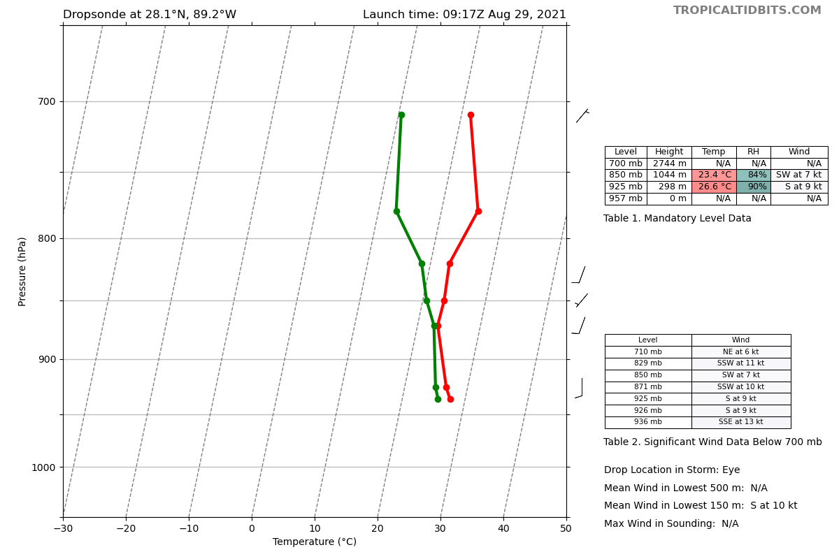
936mb
Very dry at 700mb
Usually an early indication an EWRC maybe starting soon.
 how to check if my keyboard is working
Very dry at 700mb
Usually an early indication an EWRC maybe starting soon.
how to check if my keyboard is working
1 likes
-
jlauderdal
- S2K Supporter
- Posts: 7240
- Joined: Wed May 19, 2004 5:46 am
- Location: NE Fort Lauderdale
- Contact:
Re: ATL: IDA - Hurricane - Discussion
Highteeld wrote:145 mph per nhc
Those posts from yesterday downcasting the system didn't age well.
6 likes
Re: ATL: IDA - Hurricane - Discussion
Surface and Standard Isobaric Surfaces
Level Geo. Height Air Temp. Dew Point Wind Direction Wind Speed
1000mb This level does not exist in this area of the storm above the surface level.
949mb (28.03 inHg) Surface (Sea Level) 26.2°C (79.2°F) 25.4°C (78°F) 75° (from the ENE) 103 knots (119 mph)
925mb 229m (751 ft) 24.4°C (75.9°F) 24.0°C (75°F) 90° (from the E) 142 knots (163 mph)
850mb 972m (3,189 ft) 22.4°C (72.3°F) 21.9°C (71°F) 125° (from the SE) 109 knots (125 mph)
700mb 2,651m (8,698 ft) 15.4°C (59.7°F) 15.2°C (59°F) 150° (from the SSE) 120 knots (138 mph)
0 likes
Personal Forecast Disclaimer:
The posts in this forum are NOT official forecast and should not be used as such. They are just the opinion of the poster and may or may not be backed by sound meteorological data. They are NOT endorsed by any professional institution or storm2k.org. For official information, please refer to the NHC and NWS products.
The posts in this forum are NOT official forecast and should not be used as such. They are just the opinion of the poster and may or may not be backed by sound meteorological data. They are NOT endorsed by any professional institution or storm2k.org. For official information, please refer to the NHC and NWS products.
Re: ATL: IDA - Hurricane - Discussion

0 likes
Very useful information on the Dvorak Technique --
https://severe.worldweather.wmo.int/TCF ... kBeven.pdf
https://severe.worldweather.wmo.int/TCF ... kBeven.pdf
-
weeniepatrol

- Category 5
- Posts: 1343
- Joined: Sat Aug 22, 2020 5:30 pm
- Location: WA State

-
Shell Mound
- Category 5
- Posts: 2432
- Age: 33
- Joined: Thu Sep 07, 2017 3:39 pm
- Location: St. Petersburg, FL → Scandinavia
Re: ATL: IDA - Hurricane - Discussion
GCANE wrote:936mb
Very dry at 700mb
Usually an early indication an EWRC maybe starting soon.
[url]https://i.postimg.cc/rwVgt4wL/recon-NOAA3-WB09-A-IDA-dropsonde7-20210829-0917.png [/url]how to check if my keyboard is working
NEXRAD indicates that convection in the inner core is still strengthening and the eye is contracting, so I would expect some further intensification till LF.
1 likes
CVW / MiamiensisWx / Shell Mound
The posts in this forum are NOT official forecasts and should not be used as such. They are just the opinion of the poster and may or may not be backed by sound meteorological data. They are NOT endorsed by any professional institution or STORM2K. For official information, please refer to products from the NHC and NWS.

Re: ATL: IDA - Hurricane - Discussion
Oh my god this has bombed out way more than I could’ve expected…this is awful for Louisiana. Ida could possibly be up to 135 kt at landfall.
0 likes
Irene '11 Sandy '12 Hermine '16 5/15/2018 Derecho Fay '20 Isaias '20 Elsa '21 Henri '21 Ida '21
I am only a meteorology enthusiast who knows a decent amount about tropical cyclones. Look to the professional mets, the NHC, or your local weather office for the best information.
I am only a meteorology enthusiast who knows a decent amount about tropical cyclones. Look to the professional mets, the NHC, or your local weather office for the best information.
Who is online
Users browsing this forum: No registered users and 40 guests