
https://twitter.com/news_fuentes/status/1431946901729988610
ATL: IDA - Remnants - Discussion
Moderator: S2k Moderators
Re: ATL: IDA - Hurricane - Discussion
4 likes
Personal Forecast Disclaimer:
The posts in this forum are NOT official forecast and should not be used as such. They are just the opinion of the poster and may or may not be backed by sound meteorological data. They are NOT endorsed by any professional institution or storm2k.org. For official information, please refer to the NHC and NWS products.
The posts in this forum are NOT official forecast and should not be used as such. They are just the opinion of the poster and may or may not be backed by sound meteorological data. They are NOT endorsed by any professional institution or storm2k.org. For official information, please refer to the NHC and NWS products.
-
cheezyWXguy

- Category 5

- Posts: 6282
- Joined: Mon Feb 13, 2006 12:29 am
- Location: Dallas, TX
Re: ATL: IDA - Hurricane - Discussion
Well, it looks like my guess of “as strong as Laura, plus or minus 5kt and 2mb” panned out, though at this rate it might be a tad low. Insane disaster unfolding, hopefully the track is just west enough to keep New Orleans out of the eyewall.
0 likes
-
skyline385

- Category 5
- Posts: 2728
- Age: 35
- Joined: Wed Aug 26, 2020 11:15 pm
- Location: Houston TX
-
Do_For_Love
- Category 1

- Posts: 271
- Age: 35
- Joined: Sat May 09, 2015 7:47 am
- Location: Delaware
Re: ATL: IDA - Hurricane - Discussion
StormPyrate wrote:Normally over the top intensity HWRF was not far off on this one
When I was initially following hurricanes and such I was also informed that the HWRF was a cartoon...honestly though, I feel like in the last couple of years that the HWRF was been pretty good in terms of storm structure and intensity. Not saying it still doesn't overshoot at times, but it's a predictive tool with value IMO
4 likes
Irene '11, Sandy '12, Fay '20, Isaias '20, Ida '21

Re: ATL: IDA - Hurricane - Discussion
937 mbar with 60 kt surface winds, this is probably in the upper 920s now.

0 likes

Re: ATL: IDA - Hurricane - Discussion
Special advisory issued
ESTIMATED MINIMUM CENTRAL PRESSURE 933 MB
EYE DIAMETER 15 NM
MAX SUSTAINED WINDS 130 KT WITH GUSTS TO 160 KT.
64 KT....... 45NE 35SE 20SW 30NW.
50 KT....... 70NE 60SE 40SW 60NW.
34 KT.......120NE 100SE 80SW 110NW.
12 FT SEAS..180NE 180SE 150SW 120NW.
WINDS AND SEAS VARY GREATLY IN EACH QUADRANT. RADII IN NAUTICAL
MILES ARE THE LARGEST RADII EXPECTED ANYWHERE IN THAT QUADRANT.
REPEAT...CENTER LOCATED NEAR 28.5N 89.6W AT 29/1200Z
AT 29/0600Z CENTER WAS LOCATED NEAR 27.6N 88.7W
FORECAST VALID 29/1800Z 29.2N 90.4W...ON THE COAST
MAX WIND 135 KT...GUSTS 165 KT.
64 KT... 45NE 35SE 20SW 30NW.
50 KT... 70NE 60SE 40SW 60NW.
34 KT...130NE 110SE 90SW 100NW.
0 likes


Re: ATL: IDA - Hurricane - Discussion
Do_For_Love wrote:StormPyrate wrote:Normally over the top intensity HWRF was not far off on this one
When I was initially following hurricanes and such I was also informed that the HWRF was a cartoon...honestly though, I feel like in the last couple of years that the HWRF was been pretty good in terms of storm structure and intensity. Not saying it still doesn't overshoot at times, but it's a predictive tool with value IMO
As mentioned earlier, it does good with stronger storms and overall good for short term track and strength
4 likes
Once I see the REDS and GREENS Converge on a Base Velocity. ... I'm There!!
This is NOT an Official Forecast....Just my Opinion. For official information, please refer to the NHC and NWS products.
HIGHLIGHTS : '13 El Reno Tornado : 2013 Storm Chaser Tour, Joaquin; SC flood event, Matthew '16, Lowcountry Snow storm Jan '18
This is NOT an Official Forecast....Just my Opinion. For official information, please refer to the NHC and NWS products.
HIGHLIGHTS : '13 El Reno Tornado : 2013 Storm Chaser Tour, Joaquin; SC flood event, Matthew '16, Lowcountry Snow storm Jan '18


Re: ATL: IDA - Hurricane - Discussion
Winds look to be holding steady at 130 kt. Let’s see if the AF plane finds a deepening pressure.
0 likes
Irene '11 Sandy '12 Hermine '16 5/15/2018 Derecho Fay '20 Isaias '20 Elsa '21 Henri '21 Ida '21
I am only a meteorology enthusiast who knows a decent amount about tropical cyclones. Look to the professional mets, the NHC, or your local weather office for the best information.
I am only a meteorology enthusiast who knows a decent amount about tropical cyclones. Look to the professional mets, the NHC, or your local weather office for the best information.
-
Clearcloudz

- Category 2

- Posts: 540
- Joined: Sun Jun 10, 2018 1:46 pm
- Location: Rosenberg TX


-
weeniepatrol

- Category 5
- Posts: 1343
- Joined: Sat Aug 22, 2020 5:30 pm
- Location: WA State
Re: ATL: IDA - Hurricane - Discussion
Recent reports from both NOAA and Air Force Reserve Hurricane Hunter
aircraft indicate that Ida has continued to strengthen since the
0900 UTC advisory and the maximum winds are estimated to be 130
kt. This intensity is based on peak 700-mb flight-level winds of
146 kt that have been reported by both aircraft and believable SFMR
winds of around 130 kt. The NOAA aircraft very recently reported
that the minimum pressure has fallen to around 933 mb. This special
advisory is issued to raise the 12-hour forecast intensity to 135
kt, but it is possible that Ida could peak slightly above that
before landfall occurs.
Wtf.
5 likes
-
tolakram
- Admin

- Posts: 20186
- Age: 62
- Joined: Sun Aug 27, 2006 8:23 pm
- Location: Florence, KY (name is Mark)
Re: ATL: IDA - Hurricane - Discussion
saved loop

8 likes
M a r k
- - - - -
Join us in chat: Storm2K Chatroom Invite. Android and IOS apps also available.
The posts in this forum are NOT official forecasts and should not be used as such. Posts are NOT endorsed by any professional institution or STORM2K.org. For official information and forecasts, please refer to NHC and NWS products.
-
AlabamaDave
- Tropical Storm

- Posts: 169
- Joined: Wed Aug 11, 2004 6:44 pm
Re: ATL: IDA - Hurricane - Discussion
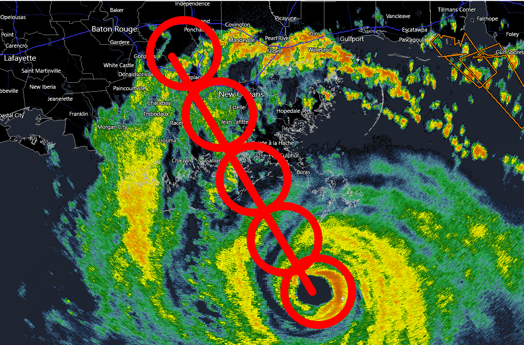
Unless I'm missing something, doesn't it look like there is a good chance a big chunk of the New Orleans metro will catch the eyewall?
2 likes

Re: ATL: IDA - Hurricane - Discussion
Kazmit wrote:Going to bed now. If current deepening rates continue, I’ll wake up to a ~935 mb cat 4.
Just woke up. Holy **** I was right.
8 likes
Igor 2010, Sandy 2012, Fay 2014, Gonzalo 2014, Joaquin 2015, Nicole 2016, Humberto 2019, Imelda 2025
I am only a tropical weather enthusiast. My predictions are not official and may or may not be backed by sound meteorological data. For official information, please refer to the NHC and NWS products.
I am only a tropical weather enthusiast. My predictions are not official and may or may not be backed by sound meteorological data. For official information, please refer to the NHC and NWS products.
-
Bad_Hurricane
- Tropical Depression

- Posts: 93
- Joined: Fri Jun 25, 2010 4:45 pm
- Location: Zagreb, Croatia
- Contact:
Re: ATL: IDA - Hurricane - Discussion
9 likes
The following post is NOT an official forecast and should NOT be used as such. It is just the my opinion and may or may not be backed by sound meteorological data. It is NOT endorsed by any professional institution including storm2k.org. For Official Information please refer to the NHC, NWS products and Donald Trump twitter account.
Re: ATL: IDA - Hurricane - Discussion
weeniepatrol wrote:Recent reports from both NOAA and Air Force Reserve Hurricane Hunter
aircraft indicate that Ida has continued to strengthen since the
0900 UTC advisory and the maximum winds are estimated to be 130
kt. This intensity is based on peak 700-mb flight-level winds of
146 kt that have been reported by both aircraft and believable SFMR
winds of around 130 kt. The NOAA aircraft very recently reported
that the minimum pressure has fallen to around 933 mb. This special
advisory is issued to raise the 12-hour forecast intensity to 135
kt, but it is possible that Ida could peak slightly above that
before landfall occurs.
Wtf.
STILL 12 hours before landfall?! Oh my god this is gonna be a Cat 5 by then, isn’t it…
0 likes
Irene '11 Sandy '12 Hermine '16 5/15/2018 Derecho Fay '20 Isaias '20 Elsa '21 Henri '21 Ida '21
I am only a meteorology enthusiast who knows a decent amount about tropical cyclones. Look to the professional mets, the NHC, or your local weather office for the best information.
I am only a meteorology enthusiast who knows a decent amount about tropical cyclones. Look to the professional mets, the NHC, or your local weather office for the best information.
-
Shell Mound
- Category 5
- Posts: 2432
- Age: 33
- Joined: Thu Sep 07, 2017 3:39 pm
- Location: St. Petersburg, FL → Scandinavia
Re: ATL: IDA - Hurricane - Discussion

0 likes
CVW / MiamiensisWx / Shell Mound
The posts in this forum are NOT official forecasts and should not be used as such. They are just the opinion of the poster and may or may not be backed by sound meteorological data. They are NOT endorsed by any professional institution or STORM2K. For official information, please refer to products from the NHC and NWS.
Who is online
Users browsing this forum: No registered users and 34 guests