https://twitter.com/watkinstrack/status/1431952585519505412
ATL: IDA - Remnants - Discussion
Moderator: S2k Moderators
-
Hypercane_Kyle

- Category 5

- Posts: 3465
- Joined: Sat Mar 07, 2015 7:58 pm
- Location: Cape Canaveral, FL
Re: ATL: IDA - Hurricane - Discussion
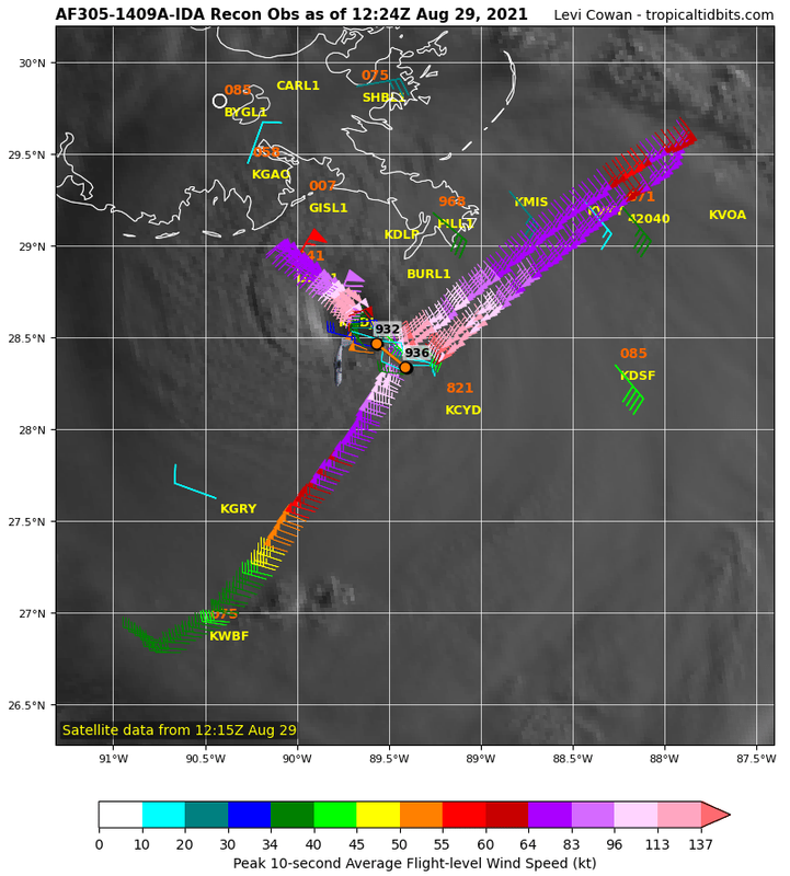
skyline385 wrote:Drop got 932mb at 32kt
That puts the pressure ~930mb. Still deepening at a decent clip.
Fancy1001 wrote:I was disappointed when Laura didn’t make it to a cat five, but I will be absolutely astonished if ida doesn’t make it to a cat five
"Disappointed" is not the term I'd use to describe that.
Last edited by Hypercane_Kyle on Sun Aug 29, 2021 7:23 am, edited 1 time in total.
7 likes
My posts are my own personal opinion, defer to the National Hurricane Center (NHC) and other NOAA products for decision making during hurricane season.
-
Shell Mound
- Category 5
- Posts: 2432
- Age: 33
- Joined: Thu Sep 07, 2017 3:39 pm
- Location: St. Petersburg, FL → Scandinavia
Re: ATL: IDA - Hurricane - Discussion

8 likes
CVW / MiamiensisWx / Shell Mound
The posts in this forum are NOT official forecasts and should not be used as such. They are just the opinion of the poster and may or may not be backed by sound meteorological data. They are NOT endorsed by any professional institution or STORM2K. For official information, please refer to products from the NHC and NWS.

Re: ATL: IDA - Hurricane - Discussion
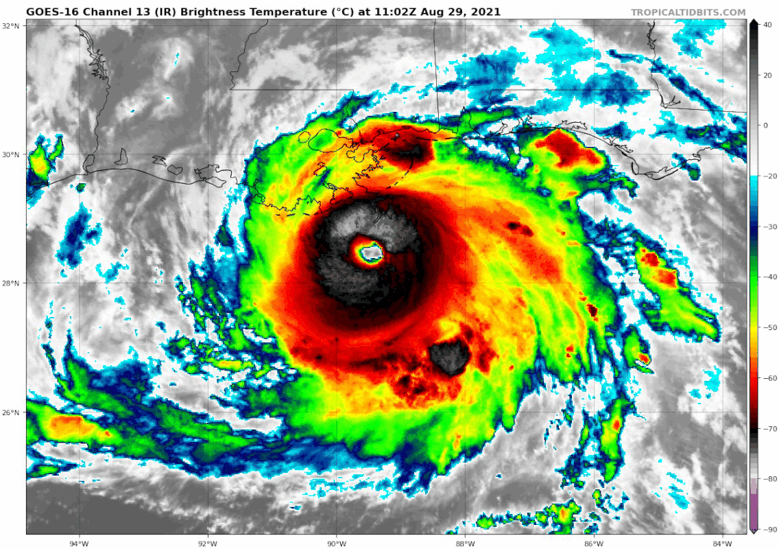
Shell Mound wrote:Is Ida entering somewhat higher shear? Latest IR and Dvorak frames show a warmer SE quadrant and a sharper demarcation between light/heavy in the NW.
Is it starting to encounter southwesterly flow on the flank of its ULAC as it begins to encounter the westernmost axis of ML ridging and enter westerlies?
Don't see the feature in the NW. The SE quadrant has been a little warm for a few hours now, but it's been firing convection in the eyewall the whole time. And immediately before that the eye had yet to circularize. What was the shear forecast yesterday?
2 likes
-
Stangfriik
- Tropical Storm

- Posts: 114
- Joined: Tue Jul 26, 2005 2:25 pm
- Location: Daytona Beach, Florida
- Contact:
Re: ATL: IDA - Hurricane - Discussion
What's happening on the eastern side just outside the eyewall?
0 likes
-
skyline385

- Category 5
- Posts: 2728
- Age: 35
- Joined: Wed Aug 26, 2020 11:15 pm
- Location: Houston TX
Re: ATL: IDA - Hurricane - Discussion
Fancy1001 wrote:I was disappointed when Laura didn’t make it to a cat five, but I will be absolutely astonished if ida doesn’t make it to a cat five
Atleast Laura was headed for a relatively low pop area, Ida isn't
1 likes

Re: ATL: IDA - Hurricane - Discussion
tolakram wrote:Jr0d wrote:kevin wrote:AF305 confirms that Ida is still rapidly intensifying in terms of pressure, 928.1 mbar now.
Extrapolated pressure is not official and often lower than the actual pressure, the dropsonde data should be in any second. Regardless, Ida has not peaked.
Here's that reading, not sure how it will be interpreted.
115530 2830N 08932W 6964 02566 9281 +226 +039 129016 023 033 002 00
I saw that. Its been a good 30 minutes since the last dropsonde from the eye.
I know from watching the data from past storms that the NHC official report is always a couple MBs higher than the extrapolated pressure we get above.
Regardless, that shows that Ida is likely below 930mb now and yet to show any signs she has peaked.
Edit:
Just saw the dropsonde with 932mb and 34kts of wind.... definitely supports a pressure of 929-930mb.
Last edited by Jr0d on Sun Aug 29, 2021 7:26 am, edited 1 time in total.
0 likes
-
skyline385
- Category 5
- Posts: 2728
- Age: 35
- Joined: Wed Aug 26, 2020 11:15 pm
- Location: Houston TX
Re: ATL: IDA - Hurricane - Discussion
Stangfriik wrote:
What's happening on the eastern side just outside the eyewall?
Are you taking about the eyewall elongating? Those are mesovotices
0 likes
-
Iceresistance

- Category 5
- Posts: 9592
- Age: 22
- Joined: Sat Oct 10, 2020 9:45 am
- Location: Tecumseh, OK/Norman, OK
Re: ATL: IDA - Hurricane - Discussion
I just woke up to this! I went to bed when Ida was at 105 mph, now she's at 150 mph! And still getting stronger! 
3 likes
Bill 2015 & Beta 2020
Winter 2020-2021
All observations are in Tecumseh, OK unless otherwise noted.
Winter posts are focused mainly for Oklahoma & Texas.
Take any of my forecasts with a grain of salt, refer to the NWS, SPC, and NHC for official information
Never say Never with weather! Because ANYTHING is possible!
Winter 2020-2021
All observations are in Tecumseh, OK unless otherwise noted.
Winter posts are focused mainly for Oklahoma & Texas.
Take any of my forecasts with a grain of salt, refer to the NWS, SPC, and NHC for official information
Never say Never with weather! Because ANYTHING is possible!
-
Shell Mound
- Category 5
- Posts: 2432
- Age: 33
- Joined: Thu Sep 07, 2017 3:39 pm
- Location: St. Petersburg, FL → Scandinavia
Re: ATL: IDA - Hurricane - Discussion
kronotsky wrote:Shell Mound wrote:Is Ida entering somewhat higher shear? Latest IR and Dvorak frames show a warmer SE quadrant and a sharper demarcation between light/heavy in the NW.
Is it starting to encounter southwesterly flow on the flank of its ULAC as it begins to encounter the westernmost axis of ML ridging and enter westerlies?
Don't see the feature in the NW. The SE quadrant has been a little warm for a few hours now, but it's been firing convection in the eyewall the whole time. And immediately before that the eye had yet to circularize. What was the shear forecast yesterday?
I was referring to the sharp, thin boundary between intense convection and light convection in the NW quadrant, near the edge of the CDO.
1 likes
CVW / MiamiensisWx / Shell Mound
The posts in this forum are NOT official forecasts and should not be used as such. They are just the opinion of the poster and may or may not be backed by sound meteorological data. They are NOT endorsed by any professional institution or STORM2K. For official information, please refer to products from the NHC and NWS.
-
Category5Kaiju

- Category 5
- Posts: 4336
- Joined: Thu Dec 24, 2020 12:45 pm
- Location: Seattle during the summer, Phoenix during the winter
Re: ATL: IDA - Hurricane - Discussion
What's particularly unique about Ida imho among the many horrific storms that have occurred in the recent stretch of active years is how it is trying its best to fit the idea of a "Cat 5 hits major US metro area." Andrew came pretty close in 1992, but Ida is doing its best to unleash its own level of horror on New Orleans sadly.
6 likes
Unless explicitly stated, all information in my posts is based on my own opinions and observations. Tropical storms and hurricanes can be extremely dangerous. Refer to an accredited weather research agency or meteorologist if you need to make serious decisions regarding an approaching storm.

Re: ATL: IDA - Hurricane - Discussion
Getting close to 135 kt especially with the falling pressure.
4 likes
-
Stangfriik
- Tropical Storm
- Posts: 114
- Joined: Tue Jul 26, 2005 2:25 pm
- Location: Daytona Beach, Florida
- Contact:
Re: ATL: IDA - Hurricane - Discussion
skyline385 wrote:Stangfriik wrote:
What's happening on the eastern side just outside the eyewall?
Are you taking about the eyewall elongating? Those are mesovotices
Yea where it has become more red rather than black and white. Thanks!
0 likes
-
StormPyrate
- Category 1

- Posts: 286
- Joined: Sun May 27, 2018 8:41 pm
- Location: Clearwater, FL
Re: ATL: IDA - Hurricane - Discussion
Interesting band building on the north west side, but not able to wrap around yet
1 likes
St Petersburg Florida
-
skyline385
- Category 5
- Posts: 2728
- Age: 35
- Joined: Wed Aug 26, 2020 11:15 pm
- Location: Houston TX
Re: ATL: IDA - Hurricane - Discussion
Stangfriik wrote:skyline385 wrote:Stangfriik wrote:
What's happening on the eastern side just outside the eyewall?
Are you taking about the eyewall elongating? Those are mesovotices
Yea where it has become more red rather than black and white. Thanks!

4 likes

Re: ATL: IDA - Hurricane - Discussion
This is turning in to a very unfortunate catastrophic deadly event unfolding and those that didn't evacuate from the barrier islands or South of Hwy 90, I-10 hopefully they did the permanent marker instructions so there is something for family members can mourn over. Sorry for such negative stuff, but there will be nothing left of most of the structures there and the shape of Louisiana will be redefined again.
6 likes
Personal Forecast Disclaimer:
The posts in this forum are NOT official forecast and should not be used as such. They are just the opinion of the poster and may or may not be backed by sound meteorological data. They are NOT endorsed by any professional institution or storm2k.org. For official information, please refer to the NHC and NWS products.
The posts in this forum are NOT official forecast and should not be used as such. They are just the opinion of the poster and may or may not be backed by sound meteorological data. They are NOT endorsed by any professional institution or storm2k.org. For official information, please refer to the NHC and NWS products.
-
Do_For_Love
- Category 1
- Posts: 271
- Age: 35
- Joined: Sat May 09, 2015 7:47 am
- Location: Delaware
Re: ATL: IDA - Hurricane - Discussion
Seems plausible to me that Ida could go sub-920 IF she continues to strengthen into landfall. She was ~935 at 6 this morning, probably 930 or so now, still deepening at ~2 mb an hour with 4-5 to go until landfall.
3 likes
Irene '11, Sandy '12, Fay '20, Isaias '20, Ida '21

-
KBBOCA
- S2K Supporter

- Posts: 1559
- Joined: Fri Sep 05, 2003 5:27 am
- Location: Formerly Boca Raton, often West Africa. Currently Charlotte NC
Re: ATL: IDA - Hurricane - Discussion
I'm not any kind of expert. Try to post tweets from only reliable sources... This caught my eye, but I'm not sure how to interpret.
https://twitter.com/hwind/status/1431956291698704391
https://twitter.com/hwind/status/1431956291698704391
1 likes
Who is online
Users browsing this forum: No registered users and 32 guests